No need to duplicate transit on Comm Ave

NB: This got picked up on Universal Hub and there are a bunch of comments there. I’ll respond to comments in both forums, but probably here more. One note of clarification: I’m not saying that this should be the plan, but that it should be considered. Like much of the Commonwealth Avenue project, the planning process has been opaque and has had no public input. Also, this comment is a great illustration of what you could have.

The Boston Globe recently ran a story about proposed changes to Commonwealth Avenue. Of issue is that while Comm Ave is wide, it is not infinitely wide, and the changes will widen the transit reservation (mainly for safety for track workers, presumably this would also allow for wider stations), narrowing the rest of the road enough that the city is reticent to add cycle tracks, because it would narrow bus stops, and stopped buses would delay vehicles. (I’m just going to touch on the fact that there really shouldn’t be an issue with delaying traffic in favor of buses, bicyclists and pedestrians, but that’s not the scope of this post.)

What I am going to point out is that all of these issues could be mitigated by moving the 57 bus route and the BU buses to the center reservation of Comm Ave with the trolley tracks. This would result in the removal of bus infrastructure from the sides of the street—buses could instead stop at the same stations as Green Line trains. While this would be novel for Boston, it has been used in other cities, and while it could result in delays for transit riders, with better stations and transit signal priority, it would result in a better experience for all customers.

There are a variety of benefits from such a plan:

  •  Buses would move out of mixed traffic, resulting in fewer traffic delays for buses (especially at the busy BU Bridge intersection) and fewer conflicts between buses and traffic.
  • The duplicative infrastructure of having parallel bus and trolley stops would be eliminated. In their place, larger, more substantial stations could be built in the center transit median.
  • Instead of waiting for either a bus or a trolley, riders could board “whatever comes first” for short trips between Packards Corner and Kenmore Square, and riders wishing to go further east than Kenmore could take a bus to Kenmore and transfer down to a B, C or D car.
  • Removing bus stops would eliminate the conflict with buses pulling across the bike lanes when entering and exiting stops.
  • Removing bus stops would allow for more parking spaces to be added to the street. The number would be small—probably in the 12 to 18 range—but not negligible, and would assuage the (dubious) constant calls for more parking in the area.
  • In addition, there would no longer be issues with cars and taxicabs blocking bus stops, requiring buses to stop in the travel lanes.
  • Wider stations would better serve disabled users, with higher platforms better allowing wheelchairs and other disabled users to board and alight transit vehicles.
  • Narrower side lanes (parked cars are narrower than buses) would allow for more bicycle and sidewalk space, including the possibility of cycle tracks.
  • Without bus stops, there would be no need for bus passengers to get off of buses and cross a cycling facility.
  • With signal priority implemented, transit travel times through the corridor could be improved for bus and trolley riders.

The main reason to not to do this is that it hasn’t been done before. The cost to pave the trackbed—and to pave it well—wouldn’t be negligible, but since the entire corridor is under construction, it would be feasible. There would have to be some study to see if the number of vehicles would cause congestion in the transit reservation.

Additionally, there would have to be a specific signal to allow buses to enter and leave the corridor at each end of the corridor—especially the east end where they would have to merge back in to traffic. However, the 57 bus would only have to merge in to and out of the left lane since it then accesses the busway at Kenmore, which is in the center of the roadway. This could be attained with a signal activated by the approaching vehicle—again, a novelty in Boston, but by no means a procedure without global precedent.

The B line has 26,000 surface boardings, most of which travel to Boston University or through the campus and in to the tunnel. The 57 bus adds 10,000 more, and the BU Bus serves countless others. There are tens of thousands of pedestrians in the corridor, and thousands of bicyclists—it is one of the most heavily-traveled bicycle corridors in the city. Yet we are planning for cars—minority users of the corridor—first, when we should be planning for transit first (by far the largest user of the corridor by the number of passengers carried), then bicyclists and pedestrians. Cars should be an afterthought, put in to the plans after other users have been accommodated, not before. Of course, had the old A line never been converted to buses, Commonwealth Avenue would not host any MBTA services, and wouldn’t need any bus infrastructure. But that battle was lost 45 years ago.

Personal data collection: Hubway

Back in 2011, as part of a convoluted New Year’s resolution, I started tracking my personal travel daily. Each day, I record how many miles I travel, by what mode, and whether I am traveling for transportation or exercise/pleasure. Why did I start collecting these data? Because I figured that there was the chance that some day it would be useful.

And that day is … today!

I realized recently that I had a pretty good comparative data set between the April to July portion of 2012 and 2013. Not too much in my life changed in that time frame. Most days I woke up, went to work, came home and went for a run. Probably the biggest difference, transportation-wise, was that in 2012 there were no Hubway stations in Cambridge, and in 2013 there were. In addition, since Hubway keeps track of every trip, I can pretty easily see how many trips I take, and how many days I use each mode.

To the spreadsheets!

The question I want to test is, essentially, does the presence of bike sharing cause me to walk and bike more frequently, less frequently or about the same? Also, do I travel more miles, fewer or about the same? A few notes on the data. First, I am using April 6 (my first Hubway ride in 2012) to July 9 (in 2012 I had a bike accident on the 10th and my travel habits changed; Hubway launched in Cambridge at the end of the month, anyway). Second, I collect these data in 0.5 mile increments, and I don’t log each and every trip (maybe next year) but it’s a pretty good snapshot.

The results? With Hubway available, I ride somewhat more mileage, but bicycle significantly more often. In addition, my transit use has declined (but I generally use transit at peak times, so it takes strain off the system) and I walk about the same amount.

Here are the data in a bit more detail for the 95 days between April 6 and July 9, inclusive:

Foot travel. In 2012 I walked 84 days in the period a total of 190.5 miles. In 2013, the numbers 83/180. (Note that I do not tally very short distances in these data.)

Bicycle travel. In 2012, I biked 66 and, believe it or not, in 2013 I actually biked fewer days, only 64. As for the distance traveled, I biked 466.5 miles in 2012, and 544.5 miles in 2013. So despite riding slightly fewer, I biked nearly 20% more distance. This can be partially explained by my participation in 30 Days of Biking in 2012, when I took many short trips in April.

In addition, in 2013 I began keeping track of my non bike-share cycling trips. I only rode my own bike 14 days during the period, tallying 44 trips on those days. But there were many days where I rode my own bike and a Hubway; I took 29 Hubway trips on days I rode my own bike; on 8 of the days I rode my own bike, I rode a Hubway as well.

Bike share trips. In 2012 I rode Hubway on 39 days, totaling 71 rides, an average of 1.8 Hubway rides per day riding Hubway. In 2013, I rode Hubway on 58 days, but tallied 185 rides, an average of 3.2! So having Hubway nearby means that I ride it more days, and more often on the days I ride.

Transit. In 2012, I took transit almost as frequently as bicycling, 61 days. I frequently rode the Red Line to Charles Circle and rode Hubway from there to my office. In 2013, my transit use dropped by nearly half, to just 31 days, as I could make the commute by Hubway the whole way without having to worry about evening showers or carrying a lock.

We might look for the mode shift here. My walking mode shift has not changed dramatically. My bicycling mode shift hasn’t appreciably increased, although the number of total rides likely has. My transit mode shift has decreased, as I shift shorter transit rides to Hubway.

Now, if they ever put a station near my house, I’ll get to see how those data would stack up. My hypothesis: I’d never walk anywhere, ever.

Site/app idea: Citizen Summons

I just almost got killed by taxicab. Again.

This is an exaggeration (I was able to brake in plenty of time after the cab cut in front of me, and then called me and the female coworker I was biking with faggots, because yeah that makes sense), but not much of one. I’ve found that taxicabs in Boston are frequently the ones hurling invective at cyclists, blocking bike lanes, dooring cyclists (oh, no, wait, the City found that), failing to yield to pedestrians, driving with their lights off at night, and generally driving in ways that endanger the public, and especially vulnerable road users.

And while every car has a license plate, cabs are particularly well-adorned with identifying markings: they have the medallion number on the front and rear, and frequently on top of the cab, and their license plate also frequently matches the medallion. In addition, taxicabs have (or at least should have) more scrutiny regarding their driving habits, as they are on the road constantly, and have more of an opportunity to be the cause of accidents (or conversely, by driving well, part of the solution). Driving a taxicab is certainly a difficult and low-paying job, but that is no reason that taxicab drivers should not be safe and courteous. With thousands of taxicabs hurtling around the area, there are certainly dozens of near-misses a day, where dangerous, reckless and even malicious behavior by a taxicab driver results in a situation where a vulnerable user is put at risk. Yet there seems to be no easy way to report these behaviors, and therefore there is little accountability.

In other words, there is certainly not an app for that.

Yet.

So here’s the idea: a website and app that would allow for the collection of data by bicyclists, pedestrians and other standers-by about the driving behavior of taxicabs. This would include a variety of features and the data could be used in several ways:

  • The data from this could be used to match poor behavior to certain cabs or operating companies, as well as to find particularly problematic locations. 
  • The program could easily send reports to the various taxi licensing agencies in local cities and towns, and to the appropriate police contacts. 
  • It would allow citizens—the ones who are almost bumped when cabs pull in to crosswalks at red lights, or the ones who see cabs lined up neatly in bike lanes awaiting fares or nearly mow down pedestrians because they can’t be bothered to turn their lights on at night—to easily send a report to the right authorities. 
  • It would allow anyone interested to view reports and find dangerous areas or medallions with particularly abhorrent safety records. 
  • It could be scaled in to a full-scale reporting system based on license plates, and focused on dangerous urban driving habits. It’s one thing to yell at the guy who honks at you and then cuts you off. It’s another to publicly shame him.

Cabs in particular seem to operate with some amount of impunity from police enforcement, but that’s no reason we shouldn’t try to gather data and hold them accountable. Plus, such a site could also allow bicyclists, pedestrians and even cab passengers to laud good driving in cabs which were courteous to bicyclists and yielded right-of-way to pedestrians in crosswalks. If nothing else, we—people who walk and bike—account for much of their customer base. We should demand accountability.

If anyone is interested in helping set this up, let me know. I’ve created some simple user-generated content sites (this and this), but this might be a bit beyond my technical expertise.

The one rule I always follow on a bike: Yield to Pedestrians

It’s big bike time, with Bike Days/Weeks/Months sprouting up across the land (some are in June; Minnesota moved theirs after we all froze our behinds off in 2009). And it’s time for bellyaching about bike sharing in New York, apparently. Oh, and for arguing about whether or not cyclists should have traffic laws enforced to the same degree as motorists.

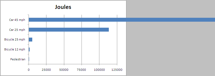
I fall in to the “not” camp, with several exceptions. This is mainly because bicyclists and motorists are orders of magnitude apart in terms of kinetic energy, and thereby damage. Consider:

Bicycle:
Average weight (rider, bicycle, accessories): 180 pounds
Average speed (in city riding): 12 mph
Top speed (in city riding): 25 mph
Average potential energy: 1175 joules
Top potential energy: 5099 joules

Automobile:
Average weight: 4000 pounds
Average speed (in city traffic): 25 mph
Top speed (in city driving): 45 mph
Average potential energy: 113310 joules
Top potential energy: 367120 joules


In other words, the average vehicle has—give or take—100 times more kinetic energy than the average bicycle. I think we’d all agree that if the fines fit the potential kinetic energy (they’d be akin to jaywalking fines, which are $1 in Boston and $2 in New York) they’d be tolerable, if laughable. (And this page is on the record as being opposed to the concept of jaywalking being illegal.) But increasingly, policies towards bikers are moving in to the “fine first, ask questions later” camp.

When it comes to red lights and stop signs, the only person a bicyclist is really endangering is him or herself. No one has ever heard about a bicyclist running in to a vehicle and injuring the occupants inside. If I go through a red light (I should say “when …”), you can be sure I’ve checked the intersection to assure that it is clear of all traffic. And much of the time in such situations I am going through so that I can get on to the next stretch of roadway ahead of—and visible to—traffic behind me.

But the one traffic rule I always do my best to follow? Yielding right-of-way to pedestrians. First, it sets a really good example. Drivers have a tough time being all high-and-mighty when they blow by a cyclist who’s stopped to yield to a pedestrian (especially when said cyclists then meets them at a red light and chastises them for their behavior, but I digress). But it’s also important because pedestrians are, in relation to cyclists, orders of magnitude less energetic. In the vulnerability hierarchy, they have much less ability to cause damage:

Pedestrian:
Average weight: 150 pounds
Average speed: 3 mph
Average potential energy: 61 joules

Here’s a simple Excel chart to illustrate (Except that the top blue bar should be about half-again as long, it broke Excel. Well not really, but it’s illustrative.):

It’s not the same differential: a bicyclists only have one order of magnitude more energy than a pedestrian; vehicles have two more than bicycles (and three more—more than 1000 times more—energy than a walker). And while it’s rare, bicyclists have killed pedestrians. (To be fair, the cyclists are generally injured in such accidents, which rarely happens when a car does something like plowing through people on to a crowded sidewalk.) But when I’m cycling, I always try to stop for pedestrians.

Am I successful? Most of the time. There are times when I’m paying too much attention to traffic and don’t see the pedestrian waiting to cross. There area few times—and I feel bad about this—when I’ve had a close call with a pedestrian walking through stopped traffic as I passed on a shoulder or a bike lane (I usually try to apologize, something difficult to do from a vehicle). But much more often, I slow down, and wave a pedestrian across. Quite often, they are surprised at the courtesy, even though they have full right of way. I often extend my arm out to warn passing cars to slow down, and have more than once weaved in front of a car to get them to slow down.

From a practical standpoint, I can usually keep enough momentum that I don’t come to dead stop, since once the pedestrian clears my bike I can start moving again (and since I can bob and weave around the pedestrian with more ease than, say, a six-foot-wide car). From a bike advocacy standpoint, it shows courtesy amongst bicyclists to more vulnerable users. (When I see a guy in a full kit on a $4000 carbon frame whipping by pedestrians in Cambridge, I get upset; I’ll defer to the inimitable Colin on this.) And from a safety standpoint, it is safer for cyclists and much safer for pedestrians.

So for red lights for me? Stopping is optional. But crosswalks? It’s mandatory.

Dear Mr. McGrory: stop the anti-bike/ped snark

Brian McGrory is a columnist for the Boston Globe, and someone told me he’s a good one. However, he has it out for anyone not driving their own car, I think, unless he is being very coy and sarcastic. When Hubway was launching last July, he proposed banning bikes altogether. It’s pretty tongue-in-cheek. Obviously he doesn’t want to ban bikes, but he wants cyclists to do a better job of obeying the rules. Sure, he posits that all cyclists are lycra-clad speedsters who run red lights with abandon. (We’re not.) I get the point; but there was probably a better way to say it.


But was that an isolated incident of non-driving hate? Apparently not. Today, after last year endorsing a war against bikes, McGrory rails against the war against cars. Apparently—and believe you me, I have not noticed this—Mayor Tom Menino, in declaring his support of bikes and walkers, has actually declared war on the automobile. So “the car is no longer king” is a battle cry. Right.


McGrory’s latest column is pure rubbish. It turns out Menino wants to convert some parking spaces to “pop-up parks” or “parklets.” This sent McGrory in to a rage. The mayor is crazy! he writes. And he needs to be committed.


Apparently, the lack of vehicular traffic is to blame for every problem in the Downtown Crossing area:

The car is still banned from Downtown Crossing, even while it’s painfully obvious that the hard luck neighborhood would benefit enormously from vehicular traffic. Cities around the country have turned their tired pedestrian malls back into real streets with great success.

Oh, where to begin? First of all, many of the country’s de-pedestrianized malls have been in places like Buffalo and Kalamazoo, not the most vibrant of metropolises. Pedestrian malls are going strong in cities like Denver, Burlington, Minneapolis and Boulder, and New York has cordoned off main streets in its retail core to widespread praise. Second, it’s quite possible that a lot of the issues in the area are due to a massive hole, and the mayor has been instrumental going as far as to threaten eminent domain takings (nothing says blight like an abandoned building) to speed reconstruction forwards. Third, it’s not like the retail district there is dead. While it might not hop at night, during the day the area is filled with thousands (by some counts, a quarter million) of pedestrians daily. Adding a few hundred car trips would be to the detriment of these hordes.


And it’s painfully obvious that cars along the currently-pedestrian streets would help? Apparently McGrory hasn’t ever been to Filene’s or Jordan Marsh (or Macy’s). The streets in Downtown Crossing are one-way, one-lane streets. They are busy with pedestrians, cyclists and deliveries, and trafficked streets nearby usually feature stalled vehicles waiting for lights. I’m not sure how a few extra vehicles in the area—and no on-street parking, assuredly—would be a panacea for the woes. A Wegmans or Target and 500 units of housing, on the other hand, might help.


McGrory concludes, after positing not an iota of actual data, that “the mayor is at war with the car, and the drivers are the collateral damage.” He, as we have seen, believes everyone drives, or at least, everyone ought to. I would contend that the mayor is simply fulfilling the wishes of the majority of voters who elected him. (Yes, believe it or not, Hizzoner still stands for elections.) 51% of Bostonians don’t drive to work, and only 44% drive (it was 51% ten years ago). Yet most of the real estate of our rights of way is given over to cars, even if they are a smaller fraction of the users on a stretch of road.


Maybe, Mr. McGrory, the mayor is simply acting in the best interests of his constituency. Or, at least, the constituency who has actually gotten out of their cars in the top walking city n the country. If you’d like, I’d be glad to take you on a walk and bike ride to some of the places you’d like to have teeming with cars instead of vehicles. Let me know.

Road Width vs Road use

When I was researching information about the new green housing development in Brighton I found some interesting numbers regarding the traffic on Commonwealth Avenue. As part of their permitting with the Boston Redevelopment Agency, a big PDF details the traffic patterns in the neighborhood, for both pedestrians and vehicles. Looking at the traffic numbers, I got the feeling that Commonwealth Avenue in Brighton is not equitably sized. In other words: the width of the road is not proportional to the number of users for each segment.

Here’s how the roadway in question breaks down (I measured it online):

The unlabeled gray sections are medians. Here it is simplified by use:

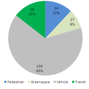
And here’s a pie chart of how many feet (the total width is 200 feet) are used for each use:

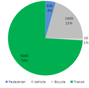
About two thirds of the street is taken up by traffic lanes, parking or medians which separate traffic lanes and parking (and provide no refuge to pedestrians and no landscaping). But of people traveling along Comm Av, fewer than two thirds are traveling by car. Many fewer. According to the study, there are, at the peak PM rush hour between 5 and 6 p.m., 1343 vehicles traveling along Commonwealth or turning on to or off of Harvard. Of these, 785 go through, and the rest turn. Counting each turner as half a trip, there are 1064 road users along this stretch of Commonwealth Avenue. Assuming some carpooling, this probably equates to about 1400 people per hour.

There was no count for cyclists. This is a frequented stretch of road by bikes, but it is certainly not bike-friendly. I’d guess that there are 50 bikes per hour in total at rush hour. (There are no marked lanes for cyclists and they have to choose between the trafficked main travel lanes or the carriage/parking lanes which have parked car hazards and more stop signs. Most choose the former.)

For pedestrians the counting is easier: there are about 300 walkers per hour.

As for transit users: the T maintains a six-minute headway along this stretch of street during rush hours. In recent years, they’ve moved from two-car trains to three-car trains, and about half the rush-hour consists along this line have three cars. That’s 25 vehicles per hour in each direction. In the peak direction, the T operates at or near crush capacity in this section, with 150 to 200 passengers per car (specs here). The non-peak direction probably operates at about one third that capacity, with 50 passengers per car (around all-seated capacity). This estimate gives us, conservatively, 5000 people per hour.

So, compare the chart above to this one:

The vehicle right-of-way, which uses the lion’s share of the street’s real estate, sees fewer than a quarter of the street’s users. Transit, with less than a sixth of the street width, carries more than triple that number. Per linear foot, the roadway and the sidewalk come out about the same. By passengers per foot of right-of-way per hour (ppfph) the numbers break down as:

  • Vehicle ROW: 11.1
  • Sidewalk: 12.5
  • Transit: 172.0

Note where the decimal is for the transit. It’s 15 times more efficient for each unit of real estate.

This can be documented for many other streets. Take the main cross street here, Harvard Street. It sees about 900 cars (1200 passengers) at peak hour, 350 pedestrians and (I’m guessing here) 60 cyclists (it was not counted in the bike count database since 1976). The street right-of-way is 78 feet wide, with 22 feet of sidewalk, 10 of bike lane and 46 for vehicles (travel and parking). Of course, the MBTA’s route 66 bus runs every 9 minutes at crush capacity (60 passengers per bus) in both directions, carrying about 800 passengers.

On Harvard, the sidewalks carry 15.9 pedestrians per foot per hour, the bike lanes 6 and the vehicle lanes 43.5. (Not terribly surprisingly, Harvard Street is usually gridlocked between 5 and 6 p.m.) This neglects to account for the efficiency of the buses. Buses demand some real estate, namely a 10-foot-by-50-foot bus stop every 1000 feet or so. That breaks down to one half of one linear foot, but for good measure we’ll assume the buses use that much street real estate during travel, and assign two of the vehicle feet to the buses. That changes the numbers:

  • Vehicle ROW: 27.3
  • Bike lanes: 6.0
  • Sidewalk: 15.9
  • Transit: 400
Does that mean that the 66 bus is more efficient than the Green Line? Certainly not. With 800 passengers per hour, the 66 is stretched to capacity: it gets bogged down in traffic, it frequently runs late or in bunches, and it crawls along its route. To add many more passengers, it would need its own lane. Even still, if, as a bus rapid transit, it took over the parking lanes (note: this won’t happen any time soon) and doubled its ridership (likely, considering how many people take it even despite its slothly pace, it would still be more efficient than the adjacent roadway.
(And one more note: we’ll look at the Red Line on the Longfellow Bridge soon, but the back of the envelope calculation is 15 trains each way carrying an average of 750 passengers each per hour in 30 feet of right of way, giving a ppfph of 750. A New York Subway line running every three minutes with 1000 passengers per train would yield a ppfph of 1333. A highway at peak capacity might be able to attain 2700 passengers per lane per mile—or a bit more with a lot of buses—for a ppfph of 225, but adding any more vehicles quickly decreases the speed and capacity.)

Will a Midtown pedestrian mall kill Midtown?

In a word, no.

The Next American City had a post regarding pedestrian malls which, in some cases, are having cars reintroduced. They were originally a reaction to suburban shopping malls, and an attempt to retain retail in former downtowns. Their success has been decidedly mixed. The pedestrian movement is moving towards complete streets, which makes more sense. Streets were once rather democratic places, but were completely turned over to automobiles (with things like jaywalking statutes). A few were further segregated, with pedestrian malls.

There seem to be two types of pedestrian mall—those where nearly everyone arrives by car, and those where the pedestrian mall is at the center of an already-pedestrian-friendly area. The former are generally small and medium cities, the latter larger cities with decent transit or college towns. Then there’s Manhattan.

Manhattan is not trying to boost a lagging retail sector. Times Square, Herald Square and 34th Street is probably the most bustling area in the whole country. And while downtown retail has suffered in nearly every city in the country, New York has a large enough transit-centric population that Midtown has no trouble even with tight, very expensive parking. New York’s attempts at pedestrianization are reactions to having given too much space away to cars—five lanes of traffic with narrow, crowded sidewalks. In addition, the diagonal crossing of Broadway caused traffic havoc, and with the box often blocked, gridlock ensued. (Well, it still ensues.) With traffic stalled and thousands of pedestrians, Times and Herald Squares resemble pedestrian malls more often than not—with a bunch of cars blocking the way.

The New York Times asked a bunch of folks (it’s a good read) if they thought that the pedestrianization of Midtown was a good idea, and everyone said yes. Well, everyone except the token nay-sayer. (Actually they had a guy from Reason who was able to say that “pedestrian malls could be viable in Manhattan.”) They had to find someone to say that the pedestrian improvements were bad for the city, and they found one Randall O’Toole.

Usually Randall expounds on a laughable, oil- and car-lobby-funded blog where he argues time and again that if we all drove everywhere it’d be great. I choose not to spend my time debunking every one of his articles (for instance: New York would do better with buses than subways) and the straw men and red herrings and use of irrelevant data (in the New York case, he argues that buses cost less per passenger mile to operate, which is true in many cities, but not in New York). But this is not a blog, it’s the paper of record (or a blog on the PoR’s website). In any case, he makes some very interesting assertions regarding the street closings in Midtown. Here are some choice quotes:

Closing Broadway to auto traffic may reduce congestion on cross streets and avenues, but limiting auto access could also turn Broadway itself into a deserted wasteland.

In 1959, Kalamazoo, Mich., tried to help its downtown compete with suburban shopping malls by closing a street to auto traffic and turning it into a pedestrian mall. Over the next 30 years, more than 200 American and Canadian cities created similar malls.

Far from helping retail districts, most of these pedestrian malls killed them. Vacancy rates soared, and any pedestrians using the malls found themselves walking among boarded up shops or former department stores that had been downgraded to thrift shops or other low-rent operations.

That’s his opening. He’s comparing Midtown Manhattan to Kalamazoo. Uh, Randall, I think there are some minor density differences going on there. And some minor land use and land value differences. Tell me, did Kalamazoo in 1959 have one of the worlds largest subway systems and two of the worlds largest train stations? Was Kalamazoo’s pedestrian mall anchored by the largest store in the world (and the flagship of the largest nationwide department store chain) at one end and the largest theater district in the country at the other?

Then, in a study of fallacies, he goes on:

In most situations, automobiles drive retail. Pedestrian malls don’t create pedestrians; they only work on streets that are already dominated by pedestrian traffic.

Where to start. “In most situations” does not, quite specifically, apply to all situations. “Pedestrian malls don’t create pedestrians.” That’s a bit of a straw man, since there’s no need to create more pedestrians in Midtown Manhattan, is there? And as for working on streets dominated by pedestrian traffic—anyone who’s ever walked in Manhattan would probably agree that that would be a fair description of the streets there.

And if you naïvely think that’s all, you’d be wrong:

Broadway might have sufficient pedestrians to maintain retail businesses — but it might not. It may be that many of the pedestrians originally arrived by taxi or in other automobiles. And given the current economy, any change for the worse could put already teetering shops out of business.

Broadway might not have sufficient pedestrians to maintain retail businesses? Seriously? If you took a poll of New Yorkers to see if they thought Broadway didn’t have enough pedestrians to support retail business I believe those answering in the affirmative would be pretty darned close to 100 percent. It might be no—from every hundredth person. And are most people arriving by taxi or car? Well, not by car. The few people who do arrive by car are paying enough in parking fees and the time cost of driving in to Midtown that an extra few minutes of gridlock won’t make any difference. Those in taxis aren’t about to drive to Passaic if the ride was a few minutes longer.

And the teetering shops? Well, I’m pretty sure Macy’s isn’t going anywhere real soon.

In any case, it’s pretty obvious Randall O’Toole hasn’t been to Manhattan, or if he did he didn’t open his eyes. If he wants to keep a blog where he proffers fabrications, fine. But if he is going to write swill like this, the Times shouldn’t give him the time of day.

But perhaps a Times commenter said it best: “Comparing Buffalo to Manhattan is like comparing Randall O’Toole to an actual scholar.”

The rise of jaywalking

As an East Coaster in the Midwest, one thing I can’t stand are people who refuse to jaywalk. In college, I’d look both ways, see no traffic and cross against the light, and my friends would stand stationary on the sidewalk. I had more than one conversation imploring them to cross—as I stood in the middle of the street. And the drivers? Well, they’re oblivious—there’s trouble crossing streets even in crosswalks.

So I’m all for jaywalking. I know the statute, and choose to ignore it at will. I was here first (i.e. pedestrians were here before cars. If there is no good reason I shouldn’t cross a street (generally an oncoming vehicle), I’ll cross the street.

And it turns out, jaywalking is good for cities. A Slate article and two blog posts discuss something interesting: streets before cars were relatively safe. Here’s Market Street in San Francisco in 1906—utterly chaotic, but nothing moving fast enough to be dangerous (it’s a cool video). Cars made them dangerous, and something had to be done.

In the early days, there were some who argued that cars should be limited or governed to low speeds. Sadly, these folks lost out to an all-out assault from auto and road interests. And the term “jaywalking”? It was foisted on to the unwitting American public. Instead of cars being a danger to pedestrians, pedestrians were now a danger to cars. And in may cases, pedestrians have gone danger, to nuisance, to, well, gone, or so marginalized on the side of eight lane arterials that they’ve all but disappeared.

Webster says jaywalking originated in 1915. Google news seems to agree. But what’s interest is how it blossomed in usage in the early 1920s and has been used to stigmatize pedestrians ever since. Google News’ archives can be very useful here, showing its use in news articles from the dawn of time. Or in this case, 1910:

Apparently, it all started in 1919. You can search each decade and various themes appear:
1920s: Debate over whether to have laws and whether laws work. Jaywalking is generally an evil. And, yes, boy scouts were deputized to warn of the dangers of evil jay walking.

1930s: Okay, we’ve decided that jaywalking is bad. Very bad. Jaywalkers will kill Main Street. And a study showed that jaywalkers actually lose time. (It was commissioned by the Elks.) New York plans to put up walk/wait signs (yeah that worked out real well, patient New Yorkers never jaywalk).
1940s: Laws get crazy. Judges get crazier. Pedestrians begin to fight back. And fines will work? Ha. (These articles are all gems.)
1950s: New York begins enforcing jaywalking rules (oh, and the paper of record says the term dates to 1917). New Yorkers don’t care. Cops in Chicago don’t care. And a few people fight back.
1960s: Laws continue. Public continues to ignore them. Or protest.
1970s: Jaywalking continues. Ordinances continue. As to people standing up to silly rules. Regionality begins. People in New York jaywalk, while those in Seattle and LA don’t.
1980s: Tickets keep coming, and believe it or not, people keep jaywalking. New York seems to give up, issuing 25 jaywalking tickets in 1989. LA issued 132,000.
1990s: New Yorkers don’t care. Bostonians really don’t care (and the fine? $1). Rudy Giuliani tries to raise fines and enforcement. New Yorkers are not happy. Cops think it is silly. And the first ticket written is dismissed. Rudy is laughed off. By 1999, the whole charade is just that. New Yorkers call jaywalking “logical.”
2000s: New Yorkers ridicule Seattle. New Yorkers use statistics, and Rudy has given up. (Jaywalking while flipping off and cussing out a cop may get you disorderly conduct, though.) Bostonians don’t care. Saint Paul doesn’t really care. Atlanta, apparently, does. Gadgets become the new menace to pedestrians. And the crusade moves to ticketing bicyclists who don’t wait for lights to change.
The tide has turned. Jaywalk, my friends. Jaywalk proudly. If, you know, it gets you where you are going a little faster.

When streets were streets

About a week ago, Infrastructurist posted about the various materials used for sidewalks. The consensus is that concrete is cheap and functional if not very environmentally friendly (both in its construction and its low permeability). Of course, in Paris, the streets are cobbled, which is beautiful, if a bit jarring to drivers and cyclists (although perhaps better than potholed asphalt).
Now, in America, except in a few instances (historic districts, or places where rich people gather, or both), streets are pavement. In some cases, concrete. Pavement is good when it’s good, but when it’s bad, it’s real bad. In other words, asphalt seems to have a wide range of conditions: new asphalt is silky smooth, but it doesn’t last in good shape. For a while it’s tolerable, until there’s a year with a lot of freeze-thaw cycles and gaps, gashes, frost heaves and, yes, potholes take over.
And that’s where we are in the Twin Cities. We’ve had an about-normal winter, but it’s been marked by a decent amount of warmer and colder temperatures. And snow. And plows. Minneapolis had enough snow accumulated that they had to ban parking on one side of narrow streets to allow traffic to flow, and all over there are huge gaping holes in the streets. And that’s meant we get to see what lies beneath.
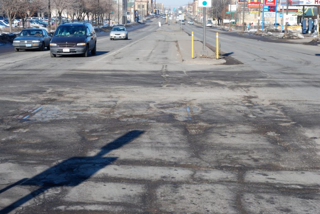
Here’s the middle of the intersection of University Avenue and Vandalia Street in Saint Paul. University was once the main thoroughfare between Saint Paul and Minneapolis, and while most traffic now takes the paralleling I-94, it is home to buses and will, in a few years, be home to the Central Corridor Light Rail. Of course, University had a streetcar line, which was very well patronized (the buses still run at 10-plus minute headways, with limited service at rush hours) until it was closed in favor of buses in the early 1950s. 
But 55 years later, the streetcar tracks, at least, are making a (re)appearance. The Google Street View from a couple years ago shows solid pavement at the corner of Vandalia and University. However, Vandalia is the route to the interstate for many trucks serving the nearby industrial area, as well as going to a large BNSF multi-modal facility, and the corner sees a lot of heavy traffic. So with the current winter, the pavement has been torn up pretty well.
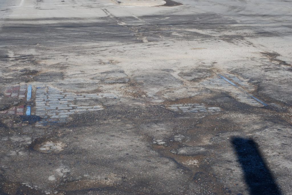
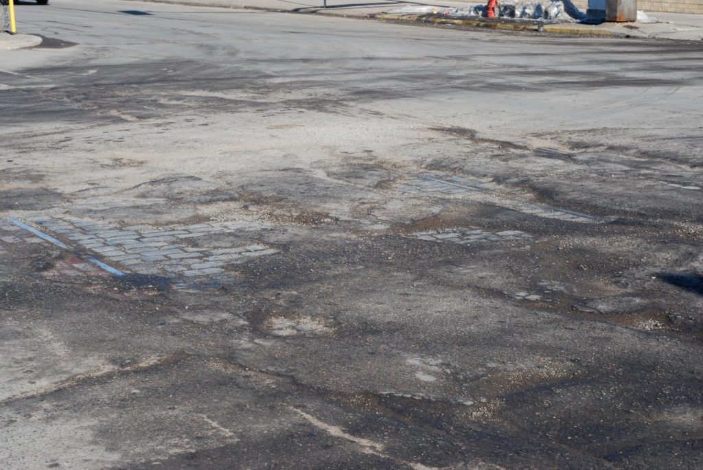
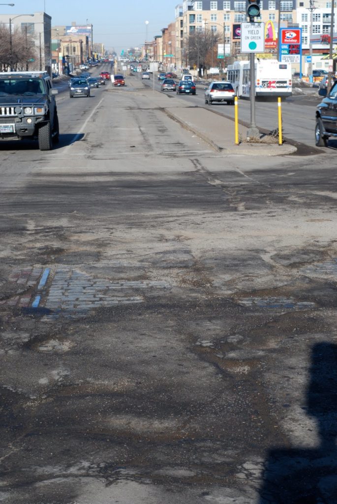
It’s actually not bad to drive on—the holes are wide enough that they aren’t all that deep (the sides generally slope) but so much pavement is gone that you can see the streetcar tracks as well as the pavement. And it’s really quite interesting. First of all, for such a wide road, the streetcar tracks really take up a small amount of room. The image above shows that the tracks are contained in a lane-and-a-half of a turn lane and median (no comment on how ugly the University streetscape is), and there are two lanes of traffic and a wide parking lane on either side.
But second, it gives us a really good idea of what streets used to look like. Here’s a closer-up look at the exposed section. The rail on the left is the southern rail of the eastbound track, the rail visible to the right is the southern rail of the westbound track. So, between the tracks were (are) gray cobblestones, and on the outside red brick. There isn’t much color film from the time, but it seems that University, with red and gray stone and silver, steel rails would be almost elegant (some trees would be nice as well). Now, with gray, gray and more gray, it’s quite drab.
Apparently bricks and cobbles don’t hold up well to heavy truck traffic, although this section seems to be doing just fine. Apparently bricks and cobbles were used along streetcar routes because they could be more easily picked up and laid down when track work was necessary. Of course, there’s a possibly apocryphal tale that Melbourne, Australia’s trams were saved when, in the ’50s, the tracks were set in concrete, so that ripping them up would be prohibitive (in the US they were mostly just paved over). The union’s intransigence there—they required two-man operation on buses, and streetcars had conductors until the 1990s, when their removal caused a crippling strike (long story short: government says “one person tram operation”, union says “no” and runs trams without collecting fares, government plans to cut power to the system, union drives trams on to streets in city center, where they sit for a month)—was probably more to blame.
When Lake Street was rebuilt in Minneapolis in 2005, the street below was in similar shape—shoddy asphalt over a firm streetcar base. Since it was not just repaved, it was dug up completely, and Twin Citians flocked to scavenge bricks from below. University, which is wider and longer than Lake Street, should be a field day for anyone who wants a new, free patio or walk—it will be fully rebuilt for the light rail line (yes, they’ve studied it, and they can’t just reuse the tracks already there).
But, why not build streets out of these materials again? The upside to pavement is that, for a while, you have a really nice road. But in the long run? You have ruts, dips and potholes. Another layer of pavement is a panacea; cracks almost always form where there were cracks before (it’s easy to find old streetcar tracks—they’re wherever there are parallel cracks running down the road). Bricks and cobbles are attractive and permeable. Water filters through, which is better for the environment. As long as there’s no heavy truck or bus traffic, they’re fine. If something goes wrong, it’s easy to make small repairs which actually last (as opposed to patches which tear out during the next thaw). And for cyclists, constant cobbles are almost better than old pavement with huge potholes and ruts, even if you have a good bunny hop.
I’m not saying it’s the way to go for every street, but in certain cases—especially if there are streetcars involved, red bricks and granite pavers may be the way to go. And in many cases, they may be lurking just below the surface already.

The saga of the Snelling Median

Over several years, a median has been proposed on Snelling Avenue in Saint Paul, to calm traffic and aide pedestrians. A long saga may soon be coming to fruition, although the local city councilmember is holding up the process. In several parts, here is the story.

A. An anecdote
B. Background and history
C. Current conditions
D. Crossing the street
E. The Grand Avenue median
F. Bring the median to Snelling
G. Project status.
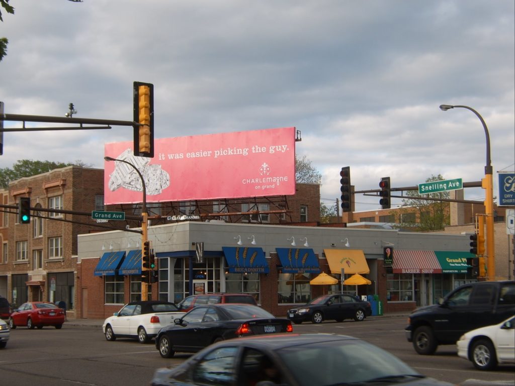
Snelling and Grand, the north end of the proposed median.

A. An anecdote

Last August, I walked from my house two blocks east, planning to attend the opening of a new athletic facility at my alma mater. There is one barrier between my house and the college, a quarter of a mile west: Snelling Avenue.

I walked down to Snelling, and—well—I’ll let my archived chat (cleaned up a bit) from that evening tell the story:

… I got to Snelling, which is four lanes wide and I did my usual walk out in the crosswalk and start waving my arms and pointing at the crosswalk as the idiotic traffic goes by completely neglecting crosswalks (I swear people are worse about stopping at crosswalks here than in Boston).

Finally, a guy in a minivan in the nearest lane stops and I slowly walk out in front of him as he glares at me. Then the car in the next lane slows down, honks at me, and speeds up.

I cross behind it and go on my way, but these cars aren’t done. The guy in the van flips me off, and then goes to bang an U-ey to come back and yell at me (Minnesotans bottle up their anger and let it out when they are driving.)—Except, the other car was in his blind spot, so he turned RIGHT IN TO IT!

No one was hurt, but the drivers were mad at me (even though the accident happened 100 feet down the road from the crosswalk). The woman in the car ran across four lanes of traffic—not in a crosswalk, mind you— and started screaming at me. I told her that it was a crosswalk and I had right of way.

Her response: “But it’s rush hour. You can’t go walking across busy streets at Rush Hour” and then claims that her mother, who was driving, is from Arizona, where the laws are different (they aren’t). The other guy also told me that, sure, maybe there is a law about pedestrians having the right of way, but it’s rush hour—they had conferred and this was their best defense. Obviously it is okay to break the law at certain times of day. (“I’m sorry officer, but I’m allowed to carry around half a kilo of cocaine at night, right?”)

The woman wanted me to stay until the cops came so they could give me a ticket … I said I highly doubted that I’d get a ticket. The cop came, and they rushed up to him. “And a pedestrian—” they stammered, but he cut them off.

“Someone was struck? Where are they.”

“I’m right here, officer, I’m fine,” I said. He sort of told them to go away and then told me that I certainly do have the right of way, rush hour or not.
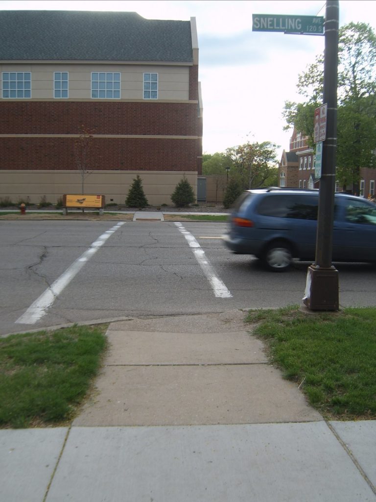
The Goodrich crosswalk where the above incident was triggered. The cars actually collided about 100 feet to the north (right) of this picture.

B. Background and history

Snelling Avenue is a main north-south road in Saint Paul, and lies about three miles west of Downtown and a mile and a half east of the Mississippi, running down the center of a lobe of land around which the river curves. It was undeveloped until the early 1900s when several streetcar lines running from downtown ran west, and one of two “crosstown” lines (the other being on Lake Street in Minneapolis) was built on Snelling. Because of its location and streetcar history, it was built relatively wide—sixty to seventy-five feet—for its entire length from Ford Parkway to Como Avenue, plus parking in most areas. When the streetcar tracks came out, Snelling became a major north-south artery—it is designated as Minnesota State Highway 51—and given four lanes of traffic plus parking.

However, it was never designed to be a freeway and serves neighborhoods which, despite the Twin Cities’ reliance on the automobile, are still rather walkable. Nearly all of the construction along and near Snelling is pre-war, and most of it is still in existence. The avenue itself is lined with a mixture of single- and multi-family housing, a few apartment blocks and commercial development. While a few sections have been given over to surface parking and strip malls, most development is still built flush with the sidewalk, and the majority of the storefronts date from the 1920s or before, often with housing above. The route is still served by a bus line, the 84, which is designated as a “high frequency route” and has 15-minute headways every day but Sunday.

Still, despite the development along the street, the wide, straight nature gives it a resemblance to many of the four lane “streets” which grace the suburbs and have 45 or 50 mph speed limits. And, for a variety of reasons, it receives quite a bit of traffic which ostensibly does not orignate or terminate along the street. The local neighborhoods have, thus far, been successful in keeping Ayd Mill Road (I will, in the future, post about Ayd Mill) from being completed to connect Interstates 35E and 94, so quite a bit of traffic crossing the Mississippi on 35E chooses Snelling to travel north to the Midway and I-94. In addition, since I-35E is not open to trucks north of the river, many big rigs use Snelling to go north. And because these drivers often have navigated wide, fast roads they often don’t heed the 30 mph speed limit on Snelling. Enforcement is relatively good—more often than not a patrol car sits at the end of Goodrich Avenue, midway between Saint Clair and Grand Avenues, looking for speeders (although not drivers failing to yield right-of-way, it seems), and usually does not have to wait long. Still, traffic, especially at rush hour, is rather frenetic.

C. Current conditions

Between Saint Clair and Summit Avenues, Snelling is bounded on the west by Macalester College. From Saint Clair to Grand, about 0.4 miles, there are no lights and no cross-streets—all of the streets end at Snelling. Thus, along this section of road, there is little to keep traffic from moving slowly. The college generally opens away from Snelling on to quads, and while the street is well-landscaped, there are not uses which interact with the street. On the east side of the street, it is generally bounded by houses which face on to the cross-streets. It feels like a road that should have a faster speed limit than 30.

However, it is highly trafficked by pedestrians as well as cars. It carries the aforementioned 84 bus route plus an express route at rush hours to Minneapolis (the 144). And while most Macalester freshmen and sophomores do live in on-campus dorms, most upperclassmen do not. During the school year, there is a steady stream of pedestrian traffic from rental properties in the neighborhood to the east to the college and back, several times a day. None of this is a problem—the college interacts surprisingly well with the neighborhood (there are isolated incidents, and some resentment of student housing causing the decay of some property, but real estate values are quite high in the area). Added together, there are thousands of trips across Snelling every day in addition to the thousands of trips along the street.

D. Crossing the street
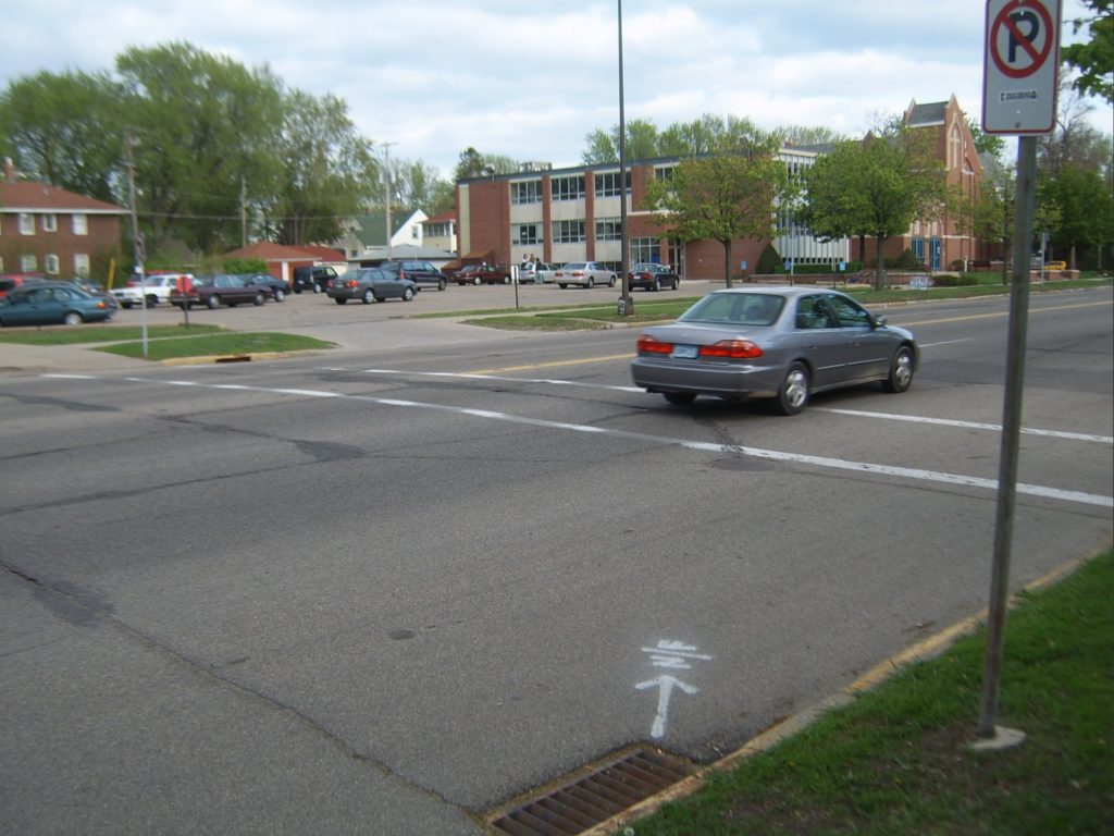

The crosswalk south of Lincoln

Herein lies the problem: it’s not easy to cross the street. Often at crosswalks, both marked and unmarked, one lane of traffic will stop for a pedestrian. However, walking in front of a stopped vehicle is nothing short of a death wish: traffic often passes stopped cars oblivious to pedestrians and statute at speed, making it absolutely necessary for pedestrians to check other lanes when crossing. With four lanes of traffic, waiting for traffic to stop in all lanes is often a cumbersome task, leading to irritation of both the crossing party and law-abiding motorists who have to wait for their less-lawful peers.

And then, as illustrated by the anecdote at the top of this post, there are those motorists who believe that they are somehow exempt from the law, and don’t find it necessary to look for or stop for motorists. While no one, to my knowledge, has been seriously injured or killed crossing Snelling, it is a proverbial accident waiting to happen. And a couple of motorists this past summer had some time with their cars in the shop because of their failure to obey the law. Perhaps, during that time, they had to walk as well.

E. The Grand Avenue median

Just west of Snelling, Grand Avenue bisects the Macalester College campus. Originally, Grand terminated at the campus, which ran north to Summit, but was extended west in 1890 to accommodate the streetcars. Grand is one of the major commercial corridors in Saint Paul, and both east and west of the college are blocks of stores. Grand is slightly wider than most of the east-west streetcar streets in Saint Paul (Randolph, Saint Clair, Selby, Minnehaha) and today sports, along most of its length, two lanes of traffic, a turn lane (despite the general absence of driveways along the street) and parking on both sides. Through the college, however, the parking lanes were eliminated and the turn lane became a striped median. Traffic didn’t zoom through campus, with a traffic light at the east end and a commercial corridor to the west, but was still able to make some speed through the campus without parked cars or storefronts.
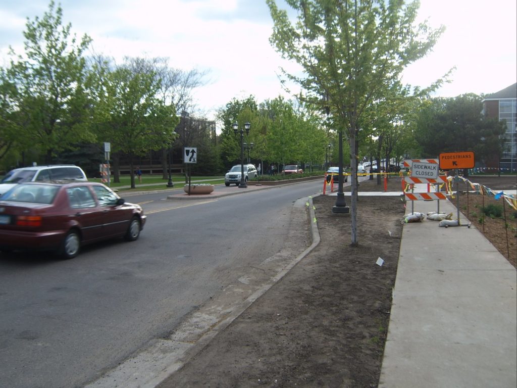
The Grand Avenue median. Much nicer than yellow striping on asphalt.

The issue was less the traffic and more the fact that this portion of Grand Avenue divides the academic buildings and dining hall at Macalester from most of the housing. Thus, approximately 1000 students daily cross Grand for classes, meals and to go to the library. On any given day are likely more feet than tires on the avenue. And for decades, the students generally crossed the street at three intersecting sidewalks between Snelling and Macalester avenues. The median was first proposed in the fall of 2002, at a time when students periodically painted crosswalks across the street, which would then be blacked out by police. (Despite current signs which state that pedestrians do not have the right of way, the crossings would appear to be “unmarked crosswalks,” extensions of sidewalks across the roadway.)

The spring of 2003 brought the beginning of experimentation, with a chain-link fence erected in order to funnel students to one crossing, but the fence was taken down repeatedly by students (not that I know any of the culprits or anything). Subsequent surveys showed that students felt safer crossing in the temporary medians which were erected. Designs changed over the next few years; parking spaces which had been planned were eliminated, and the communited supported the median as well. It was erected in late 2004 and has beautified the street, created a better environment for pedestrians and not had any major ill effects.

F. Bringing a median to Snelling


View this map larger in a new window
Map of the area of the Snelling median

The median on Grand was not very controversial. The only abutter was the college, the center of the street was already striped as a median, and no businesses were impacted. The college footed most of the construction bill and the street is safer today for all. On Snelling, the median would be quite a bit longer and involve dozen of abutters and several cross streets. Furthermore, since Snelling is a state highway, the Minnesota Department of Transportation is involved. In other words, there is a much greater opportunity for dissent.

The median is being spearheaded by the Macalester High Winds Fund, Macalester’s community liason and real estate management. The Mac-Groveland community has also been heavily involved in the process. The community has generally been in favor, but not completely. The pros are generally rather obvious (calmer traffic, easier crossings, &c.) but the cons are a bit harder to figure, but still somewhat important to examine. According to several articles, they break down to:

• The potential loss of parking, especially near Grand and the new athletic facility
• Increased congestion related to slower traffic
• The elimination of left-turning traffic on to two streets (Sargent, Fairmont, Lincoln is currently one way and on to which turns are not allowed), and the subsequent addition of traffic to some streets (Goodrich and Osceola)
• Loss of access to some businesses, notably Lincoln Commons between Lincoln and Grand
• Narrower areas for bikers
• No pull-offs for buses

There are other concerns, but these are the most well-founded—the others are raised by citizens going on about the spoiled brats who dare to cross Snelling or residents who refer to Snelling as a highway (which it, historically, is not).

First, parking. Parking is a very frequent planning concern and probably one of the most unheralded (since it is not at all “sexy”), even in neighborhoods such as Mac-Groveland where parking is ample and generally free. Along Snelling, there are three distinct parking issues. The first is near Saint Clair. Here, some street parking would disappear, but its impact would be minimal. The stores along Snelling north of Saint Clair have parking behind, and on the west side the street borders the Macalester stadium, which is rarely a driver of major traffic. During events which do create traffic, the street parking fills rather quickly and then spills on to neighboring streets, but, again, this does not occur frequently.

Between Sargent and Lincoln, parking is rarely an issue. On the west side of the street, it is bordered by college buildings which do not drive huge amounts of traffic or, if they do, provide ample parking. The on-street spaces which might be eliminated are already minimized by bus stops and loading zones, so at most a few cars would spill on to the east-west streets, which, except during events at the athletic facility, have ample parking. The new athletic facility lots provide more parking than the ones which were replaced, even though it serves the same sized community. Except during events, it is rarely full. The church across the street has a large parking lot which is also underutilized.

The main concern is north of Lincoln. Here, street parking is rather heavily used for local businesses, especially at the end of rush hour. While businesses do provide their own parking (Lincoln Commons is a very small strip-mall) it is sometimes not adequate in the evening. However, the number of street spots available is minimal. North of Lincoln Commons is a bus stop and turn lane, and parking is prohibited. South of it, there are several driveways which preclude parking. Five spots, at most, would be eliminated which directly serve these businesses, and the lack of these spaces may ease congestion entering and exiting the lot.

This segues well in to the next issue: the elimination of left turns in to Lincoln Commons. Lincoln Commons is a four-store (a Kinkos-Fedex, a coffee shop, a hair salon and a fish store) urban-strip mall development. Unlike some parts of Snelling (notably the Cheapo Discs north of Summit, which has a parking lot far larger than necessitated) it is not set back far from the street and the parking is minimal and well-landscaped. Lincoln Commons is on the west side of the avenue, and while Lincoln Avenue, at the south end of the block, is one-way towards Snelling, Lincoln can be entered and exited to the southbound side of Snelling. There is a minimal turn lane from these lanes, which allows traffic to access the complex without tying up Snelling while waiting for the northbound lanes to clear. However, the rigmarole to access the complex seems quite dangerous—sitting in the middle of a busy street with cars passing by on both sides in opposite directions. In fact, it does not meet current safety protocols and would likely be eliminated by the Department of Transportation in upcoming years. It is also not particularly pedestrian-friendly, with traffic turning from thirty or forty feet and often gunning across the sidewalk in an attempt to clear small breaks in traffic.
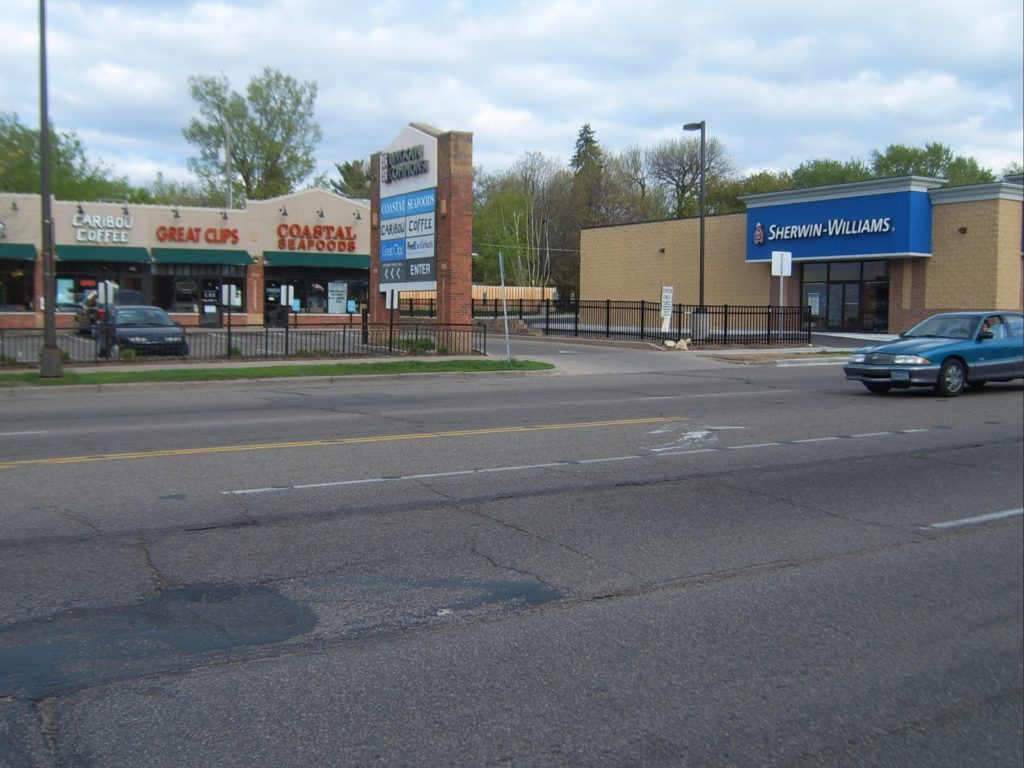
The left turn “lane” in to Lincoln Commons.

The proposed median would cut off the southbound lanes of Snelling from Lincoln Commons, meaning that it could only be accessed and enterd from the northbound lanes. The concern amongst the businesses is that this will necessitate a longer procedure for southbound customers. Instead of a left in to the parking lot and a left out, they’ll be forced to make a U-turn in to the northbound lanes, a right turn in to the lot, a right out of it, and another U-turn at Grand, or a combination of turns to return to Snelling southbound. These will add time, but they will also require much less risky maneuvers, namely nixing the double mid-block left turns across the Northbound lanes of Snelling. It will help pedestrians as well, as cars will only come from one direction, and won’t have to worry about opposing traffic and pedestrians. It is not a perfect situation—it will probably have a minor effect on these businesses (especially the fish store, which is often visited by commuters for a short time to pick up dinner during evening rush hour)—but also not one which will effect the businesses to the extent that they will see a major negative impact in sales.

In fact, in the long term, it may help. If the neighborhood is more walkable—that is, if Snelling is no longer perceived as a barrier—they will expand their market for customers who do not drive. In fact, if the procedure for parking involves four moves (U-turn, right turn, right turn, U-turn) instead of two, it may entice some local residents to walk or bike, rather than driving. Consider, for instance, two potential markets. The first lives several minutes drive from Lincoln Commons, or pass the complex as part of a longer commute. They are coming to the stores there for a specific service they can not find closer to home, and driving is likely their only means of transportation. For these customers, the median may add one minute to a fifteen minute trip, an insignificant change. They’ll still come, and they’ll still drive.

The other market is made up of nearby residents, who may live only two or three minutes’ drive away, comparable to a walk of five or ten minutes. Most notably, I am thinking of residents who live west of Macalester. For these customers, adding a minute to their drive time would be an increase of 20-25%, making it significantly longer. However, their walking time would remain the same, and may even be shorter, and certainly more pleasant. For this customer base, the complex would be further in terms of driving time, but perhaps closer overall. And pedestrians do not require parking spaces.

There is also the concern that eliminating left turns on to and off of some streets will result in an increase in traffic on others. This is not a major issue because these streets only serve the immediate neighborhoods—all through traffic follows Grand or Saint Clair which lack stop signs. Traffic on these streets is quite minimal, with no more than a few dozen cars each hour. Doubling the traffic on any street would not be noticeable—they’d still be quiet, residential streets. In addition, with some turns blocked off, traffic would be more likely to utilize the north-south streets to access Grand and Saint Clair, and subsequently Snelling. Traffic patterns will change, and traffic may become more concentrated, but the number of cars involved are low enough that it will be a nonissue.
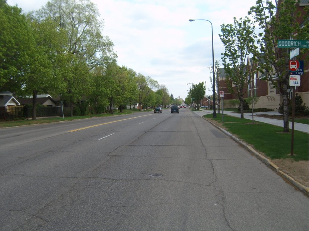
The Snelling “raceway.” Note the lack of any parking lane markings, making the street seem even wider than it is.

The next issue, congestion related to slower traffic is, in my opinion, a very minor concern. The main issue with more congestion is for those who consider Snelling to be a trunk highway. It is not. It is a city street, and for a variety of reasons, has a lot of traffic. Still, it is not congested. Traffic counts on the street are approximately 25,000 per day, which is not particularly high for a four-lane road. It is rare for traffic to have to sit at lights for more than one light cycle, and between intersections, traffic moves too quickly if anything. If anything, traffic calming would ease congestion. Instead of jackrabbit starts and braking for red lights from 40 mph to zero, it would allow for smoother traffic flow. The amount of congestion on such a street is not dictated by the speed of the traffic, but by traffic lights and turning vehicles. Reducing turns would do far more to ease congestion than reducing speed would to create it.

The median will mainly change conditions for motorists and pedestrians, but will also effect cyclists and transit riders. There is some concern that the narrowing of the street from five lanes (or even seven, if the parking lanes are included) to four will create a hardship for bikers, who will no longer have a wide, and often empty, parking lane in which to seek refuge. There are two reasons why the new design may actually benefit cyclists. The first is that it will better define the uses of the street, on which there is currently no delineation be the travel lanes and parking lanes. While bike lanes are not in the current design, it is possible they could be demarcated at a later date. The second is that biking on Snelling is currently rather horrid. If the avenue becomes more like Lexington Parkway, the north-south street a mile east, it will be superior to the current conditions.

Finally, the buses which ply Snelling four (or more) times per hour will no longer have stops in which to pull off at minor cross streets. This, too, is a minor issue. First of all, most bus ridership is concentrated at Grand and Saint Clair, where there are bus shelters and benches, as opposed to signposts. So buses usually stop for only a few seconds. Secondly, buses waste quite a bit of time pulling off the travel lane to pick up passengers and then having to attempt to merge back in, where drivers only sometimes yield right of way. And since Snelling will still have multiple lanes in each direction, traffic will be able to pass buses if they need to stop for longer periods of time.

G. Project status

The High Winds Fund at Macalester has been instrumental in securing funds for the Snelling median, which has received the approval of the neighborhood council as well. In addition to state funding, an appropriation of $475,000 was received from Congress, since it was federal legislation which made Snelling the de facto route for truck which might otherwise use I-35E. However, to received the state funds, and probably the federal funding, the project must start by June 30.

The ducks are all in line, except for one: The local councilmember, Pat Harris, has long been opposed to the project. The Lincoln Commons landlord has been unhappy about the perceived lack of business (which, as discussed, may not even be the case) and wanted the median to start south of his complex—negating the effect of the median where the plurality of accidents have occurred, and cutting off the possibility of state money. It will come down to a few days and community participation as to whether the median will come to fruition—or get caught up in local politics. If it does, it will be to the detriment of thousands of pedestrians in a supposedly walkable neighborhood.

Finally, like it or not, this is a shovel-ready stimulus project. Assuming we can agree that on its merits it is at least palatable, it will bring in jobs to the community. Can we afford not to do something like that?