The odd history of the 66 Bus Wiggle

One frequently-mentioned (and usually fallacious) argument is that we need to rework our bus routes because they follow the same routes as they did in the days of the streetcars. (This is a fallacy because, in most cases, the streetcars followed the path of least resistance: straight, wide roads with mixed uses and density. In Houston the uses had changed so drastically since the streetcars it made some sense, in older, denser cities, it doesn’t.) Then there’s the case of the 66 bus in Boston, Brookline, Boston again, and then Cambridge, particularly the two-sides-of-a-triangle “wiggle” to Union Square in Allston. (Here’s a visual primer on the 66)

This isn’t entirely true. There are a lot of reasons why the
66 bus sucks. But this shows the wiggle well.
Via here.

The wiggle stems from a route realignment in 1989, where several routes were rejiggered, which is the type of route realignment I think the T should do more of. Before 1989, there were several routes which terminated in Union Square in Allston, not because it is a major activity locus, or a major transfer point, but because back in the day, there was a car barn there and BERy decided to start and end routes there. Back then, the following routes served Union Square Allston:

  • 57 Kenmore to Watertown Yard
  • 63 Cleveland Circle to Central Square via Western
  • 64 Oak Square to Central Square
  • 66 Allston to Dudley (note that there was never a streetcar line across the Anderson Bridge; this was always a bus line)
  • 86 Union Square Allston to Union Square Somerville via Harvard

After the changes, except for the 57 and 64, the routes were split apart and recombined at Union to better serve the needs of the traveling public (what a thought!). The 63 was combined with the 86 to form the current 86 bus (which had been extended to Sullivan in 1981 a few years after the Orange Line was realigned). The 66 was then extended to Harvard Square to cover the section in Lower Allston the 86 bus missed. This better focused service towards Harvard (where subway connections were, since 1985, available in both directions, and which has more terminal capacity than Central) and provided a one-seat ride between Brookline and Harvard for the first time, leaving us with the current routes:

  • 57 Kenmore to Watertown Yard
  • 64 Oak Square to Central Square
  • 66 Harvard to Dudley 
  • 86 Cleveland Circle to Sullivan

Initially, the 66 was routed straight through on Harvard Ave. Apparently there were protests (not sure by whom; see comments) and that the route no longer served Union Square and it was realigned, and since then has cost through-riding passengers (the majority, although maybe not at the time on the new route) several minutes of travel time. The gist of the protest, as far as I can tell, is that you couldn’t get to Union Square on the 66. But this is not a valid argument. The 66 intersects the 57, another high-frequency bus route, which serves Union Square. If you are unable to make the (short) walk to Union, you can instead utilize the transfer feature of the bus network. Most users can walk the 1200 feet (a 4 minute walk) to Harvard Ave; others can use the every-ten-minutes 57 bus and transfer (or the every not-nearly-as-often-as-it-should-run 64). Apparently, planners at the time kowtowed to these complaints. It probably costs the T tens of thousands of dollars in operating costs every year, and likely reduces ridership as potential riders choose other modes because of the length of the route.

A straightened route would consolidate several stops at Harvard and Commonwealth, which could be rebuilt as a high-amenity stop (larger shelter, higher curb, real-time arrival display, signal priority, etc). The few passengers who need to get to Union Square and can not make the walk could, instead, ride the 57 (or even the 64). No stop would lose service (the entirety of the wiggle duplicates other routes) and it would make the 66 faster and more reliable. We hear that the T should replicate Houston’s bus realignment program (it shouldn’t). But small changes like this which would pay dividends are barely even considered. They should be.

Visualizing Street Widths in the Boston area

There has been a lot of discussion in the Allston task force about street widths in the area there. Since Google Maps and StreetView gives us a great way to measure the widths of streets and look at their profiles, here are many streets in Boston—most of them commercial streets but some others shown as well. They start from narrow streets in the oldest neighborhoods and range to the widest streets of the Seaport (I left out highways and streets with transit reservations). This should be a good resource for looking at what different street widths can accommodate. 
Note that these widths are building-to-building, or the outside edge of the sidewalk on each side. 
There seem to be groups of streets, and how a street is built is often very different even when the width is similar. In Boston, there are many streets that are 36 feet wide, 50 feet, 60 feet, 66 feet, 80 feet, 90 feet and 98 feet (many major roads are this wide, and their character varies significantly). Very few roads are any wider than that, except for some streets in the Seaport which are 132 feet wide. Here are streets shown, from narrowest to widest.
20 feet, Margaret Street, North End.
32 feet, Temple Street, Beacon Hill. 
32 feet: Melrose Street, Bay Village.
36 feet: Pinckney Street, Beacon Hill.
36 feet: School Street, Downtown.
50 feet: Mount Auburn Street, Harvard Square, Cambridge.

50 feet: Washington Street, Downtown Crossing.

50 feet: West Newton Street, South End.
58 feet: Centre Street, Jamaica Plain.

58 feet, Tremont Street, Downtown

60 feet: Elm Street, Davis Square

60 feet: JFK Street, Harvard Square.
66 feet: Cambridge Street, Inman Square.
66 feet: Charles Street, Beacon Hill.
66 feet: Harvard Ave, Allston.
75 feet: Beacon Street, Back Bay.
80 feet: Washington Street, Brookline Village. 
82 feet: Mass Ave, Back Bay.

82 feet: Kneeland St, Chinatown
82 feet: Columbus Ave, Egleston.
90 feet: Newbury Street, Back Bay.

90 feet: Boylston Street, Copley Square. 
90 feet: Columbus Ave, South End.
90 feet, Main Street, Kendall Square (under reconstruction).
98 feet: Cambridge Street, Beacon Hill .

98 feet: Brighton Ave, Allston.

 98 feet: Cambridge St, Allston.

98 feet: Mass Ave, Central Square.
98 feet: Mass Ave, north of Harvard

98 feet: Summer Street, Seaport.

98 feet: Tremont Street, South End.

98 feet: Boylston Street, Fenway.

98 feet: Mass Ave, South End
110 feet: Columbia Road, Uphams Corner.
120 feet: Blue Hill Avenue.

132 feet: Seaport Blvd

132 feet: Congress Street, Seaport.

How the North South Rail Link could work

North South Rail Link schematic showing current train volumes for Commuter Rail
lines, potential future RER-style connections and new and existing stations.

Discussion about the North South Rail Link has bubbled up again, with Mike Dukakis and Bill Weld writing in the Globe about how it should be a priority, Commonwealth magazine calling them out on where the money would come from, and Dukakis replying that if you wanted to find the money, you certainly could. A thread started on Universal Hub with a lot of people wondering how the rail link would function. Here are my thoughts/explanations.

Efficiency. The crux of the issue is that MassDOT wants/needs more space at South Station (and eventually North Station) and is limited by the number of tracks. Turning trains around is time-consuming: you have to unboard (deboard?) the train, board the train (even at rush hour, 50-100 or more reverse commuters may be waiting), have the crew change ends, and then thread out the same slow trackage you came in. Even with the best of practices, a terminal station track can only accommodate a train every 15 minutes or so. But if trains run through, boarding and alighting is faster and easier, there’s no need for the crew to change ends, and with more destinations,  fewer passengers get off at each stop. You could route 20 trains per hour per track, meaning that four tracks in the rail link could do the work of 20 at South Station (currently there are 13; the expansion would add about a half dozen more).

Electrification. You need to electrify the whole system (and maybe Amtrak to Portland). Maybe you could get away with dual mode engines, but that’s lipstick on a pig. Electrification of the Commuter Rail network would cost somewhere in the neighborhood of $1 to $2 billion dollars. Not cheap. But huge operational efficiencies: electric trains are cheaper to run, cheaper to maintain, and have faster acceleration meaning that trip times (and staff costs) are shorter, while ridership is higher (faster trains = higher ridership).

North/South imbalance and the Grand Junction. The idea behind the North South Rail Link is that trains coming in to South Station run through the tunnel and out one of the North Side lines. This is the Philadelphia model. This works well in theory (some passengers would get a one-seat ride; others would have to change), but in practice more trains run in to South Station than North Station (although this was not always the case; in 1972 there were twice as many passengers at North Station). Several pair off relatively well:

Needham-Haverhill
Providence/Stoughton-Lowell
Franklin-Fitchburg
Old Colony Lines-Eastern Route

But falls apart when you realize that all the North Side routes are taken and you haven’t accounted for the Worcester or Fairmount Lines. You could route them through to other terminals, say, to Anderson Woburn, but this seems wasteful; you don’t need a train every 8 minutes inbound from Woburn. This is where the Grand Junction comes in. If it were grade-separated in Cambridge (or maybe even if not; there are grade crossings in downtown Chicago with 20 trains per hour at peak times), Worcester Trains could split off at West Station (hopefully) and make a loop (much like lines in Melbourne, where a similar imbalance existed), serving Yawkey, Back Bay, Downtown and Kendall. As for the Fairmount Line …

Potential for RER(/S-bahn/Crosslink)-style service. Having the rail link in place with the Grand Junction connection would not only allow you to route trains through the city, but it would also allow you to implement RER-type service filling much of the urban ring and providing more frequent service than Commuter Rail (although Commuter Rail could run more frequently as well). If all the paired lines shared one set of tunnels, the Worcester Line could share the other with the following RER-type services:

Allston to Assembly via Cambridge (Kendall) and Sullivan
Readville to Allston via Downtown and Cambridge (Kendall)
Allston to Chelsea via Downtown and Sullivan

These would operate frequently all day, every 10 to 15 minutes, allowing transfers between subway and Commuter Rail. This leverages the capacity of the rail link to create a complementary urban rail network to provide new connections and take some pressure off the existing hub-and-spoke network.

Get rid of North Station. Most ideas about the Rail Link include three downtown stations. But you only need two. Where North Station is today is convenient to very little, and the half mile to its north is taken up by highway ramps and water. A better idea would be a station between Aquarium and Haymarket. It still allows for transfers to all subway lines, and there is very little that is less than a 10 minute walk from North Station but more than a 10 minute walk from Haymarket. It would save money, too. (Obviously, the existing Green/Orange line station would remain.)

Open new land to development. Much of the land near North and South Stations is taken up by trackage, and the Rail Link, obviating the need for these stations (a couple of tracks to use in emergencies and for trains like the Lake Shore Limited might make sense, at South Station especially, although these trains could operate to West Station and provide connections there instead), and this would be very valuable land. In addition, it would render Boston Engine Terminal obsolete as maintenance would be for electric vehicles, and if maintenance facilities were rebuilt on less valuable land (say, in Billerica or next to the Anderson/Woburn station). Based on what Northpoint just sold for, it would be worth maybe half a billion dollars in development rights. A lot of this money could be captured to help pay for the rail link itself.

Will the North South Rail Link happen any time soon? Probably not. But hopefully this will help people understand its potential (which is huge!) and what we’re talking about when we talk about the NSRL.

Allston: Let’s look for a win-win

This is a straight quote from Fred Salvucci about the Allston viaduct: instead of talking about shared pain, we should talk about a win-win. He also referred to my plan as “genius” (or maybe me as a genius, I am too verklempt). Anyway, talk amongst yourselves; I’ll give you a topic: here are a couple of updates regarding some technical-ish aspects of the Allston project, to address a couple of concerns I’ve heard from some people.

1. There won’t be a direct yard lead from the Worcester Line trackage east in to the train stabling yard. The answer is … yes, probably, let’s talk about it further. In the previous iteration, I had the Grand Junction viaduct descending from to West Station at the same time as the Worcester Line ascends. The issue is that for a Worcester yard lead to leave the Worcester alignment, it needs to stay fully at the base grade until the end of the “throat” section before crossing under the Grand Junction.

So, how do we do this? Well, first, the Grand Junction viaduct needs to continue at its grade (24′ above grade) for about 50 more feet to allow the railroad track to pass under it, feasible with no more than a 1% grade. And the Worcester Line would need to proceed at its grade (0′) to the end of the viaduct, before ascending to the station and assume a low grade beyond since it will be made for low-speed yard moves (let’s assume 0.5%). This all works (although the yard may have to be dug out a bit lower, which will be better for eventual air rights). I discussed crossing one of the Worcester Line tracks under the Grand Junction recently, to allow for island platforms and easy transfers.

The issue is that then the Worcester Line would have to ascend to West Station, and it would have to do so at a higher grade, in this case, 1.5%. However, I think this is feasible. There is currently no freight east of the Beacon Park area on the Worcester Line. 1.5% is steep for passenger trains, but there is a mitigating factor: it would be traversed uphill by trains decelerating westbound to West Station, and downhill by trains accelerating eastbound from the station. So the gravity would actually aid the trains in and out of the station.

Here’s a drawing:

2. There is a question of the support structure for the Grand Junction viaduct. I am not a structural engineer (as I’ve said before), and it’s certainly a possibility that the single center posts would not be sufficient to support freight rail. This could be mitigated with supports on both sides of the eastbound Turnpike. While not as elegant as the single post design, it’s quite possible that it would be required for 150-ton freight railcars and heavy rail passenger trains. This is obviously something that needs further study.

Quick Allston update

I’ve had some questions about my Allston plans along the lines of “how steep do the slopes need to be to match the grade of the Worcester Line and Grand Junction Line at the proposed West Station?” There have also been concerns about the grade of the Grand Junction rising from beneath the BU Bridge to ascend over the Turnpike.

The answer to the first question is: not very steep. I’ve gone over the grades before but have illustrated it in somewhat more detail below. It’s perfectly feasible with a 1% grade; basically, you have about 1100 feet for the two lines to meet, and one can ascend while the other descends. This would put the grade of the track in the station at 14 feet—slightly lower than the current railroad—and about 10 feet lower than the adjacent streets in the BU Campus.
[Quick clarifying update on the above chart: dashed lines for the Grand Junction and Turnpike show areas where their alignments are outside of the constrained right of way area; for the Grand Junction, across the BU Bridge, and for the Turnpike, towards the toll plaza.]

The long and short of it is that the further west you move West Station, the lower it can sit. If it were moved to Cambridge Street, it could be at a grade of 0 feet, well below the current grade, although it would be much further from the core of the BU Campus. Wherever it is is a compromise: further east is higher (really anywhere west of Ashford Street would be a split-grade station with ramps or stairways between the two lines) and further west is lower. It would also be possible to have the Grand Junction in the center and the Worcester Line split on the outside; this might be preferable to easily enable cross-platform transfers. NB: Drawing not to scale:

Phasing the Grand Junction viaduct

In a previous post, this page explored how the Allston Turnpike relocation could be built without a large road viaduct. Thanks to input from several sources, here is a very rough idea of how it could be phased, with no interruption to Turnpike traffic or Worcester Commuter Rail line (aside from quick weekend-long changeovers) and only minimal closures (in the months range, not years) to the Grand Junction railroad. Note that while these are largely to scale, they are by no means engineering drawings, and that (especially laterally) there may be changes, as I am estimating this off of measuring aerial photographs on Google Maps, not actually surveying the highway.

I am first going to show the elevations for each phase, crossing at a point in the middle of the current viaduct. There will obviously be differences at either end, where roads and railroads will have to ramp up or down to reach the construction phase. However, those will be shown in the aerial views, further down. In each of these, the Charles River is on the left, and Boston University is on the right, in other words, they are looking east. The scale in feet, with a grid showing every 20 feet horizontally and every 10 feet vertically.

Current conditions have the Turnpike on a viaduct over the railroad, Soldier’s Field Road (SFR) and the bike/ped facility (Paul Dudley White Path, or PDWP).

In Phase 1, several steps would occur:

  1. Soldier’s Field Road is relocated towards the river and potentially narrowed slightly (Memorial Drive is 10 feet narrower than SFR yet still has four lanes of traffic). The PDWP is moved slightly towards the river.
  2. The DCR “parkland” between SFR and the Turnpike—currently weeds and gravel—is excavated approximately four feet and three westbound Turnpike lanes are build there. Three lanes are viable during the project, as the current three westbound lanes (owing to the Commonwealth Avenue bridge project) are suitable for traffic volumes. This grade is four feet lower than the current Soldiers Field Road, level with the lowest point where the Turnpike crosses under Commonwealth Avenue.
  3. The Grand Junction is retained under the westbound Turnpike lanes. A new, permanent bridge is built for the railroad over SFR, with extra width to accommodate a bicycle/pedestrian path looping up to the BU Bridge (and eventually the “People’s Pike” along the Grand Junction to BU and Allston). The new bridge is also built for the Grand Junction under the existing Turnpike viaduct, while the Grand Junction’s current connection is kept to the north. A ramp down to grade is also built below the current viaduct.
  4. Once at grade, the Grand Junction alignment is moved slightly south to allow excavation and construction for foundations for supports for the new Grand Junction viaduct. These can be built during or after the Turnpike viaduct is removed.
  5. The PDWP is relocated under the new, wider Grand Junction bridge along SFR, eliminating the dangerous (narrow, bumpy, slippery when wet, poor sight lines) boardwalk under the BU Bridge. There is plenty of room under the BU Bridge for both a level path and a ramp up to parallel the Grand Junction (24 feet, enough for each path to be 12 feet wide).
  6. The Turnpike is moved under the new Grand Junction bridge and on to the temporary alignment. At this point the Grand Junction’s current alignment is removed and service is suspended until the viaduct can be removed above the easternmost section of the Grand Junction. Once this is done, the rest of the removal can proceed with the line in service, with care to be taken to allow for daily and as-necessary traffic on the Grand Junction. 
  7. The westbound Turnpike ramps back up to the viaduct near where the current exit ramp leaves the mainline. A spur track is built under this westernmost area to serve Houghton Chemical. 
Phase 1A (above) shows how temporary supports would be built on the south side of the highway (near BU) and the right of way slightly widened to allow for the Worcester Line to be relocated from underneath the viaduct structure.

Once Phase 1 is completed, half of the Turnpike has been removed, and the supports for the Grand Junction viaduct have been put in to place. In this phase, second half of the Turnpike comes down. For this to occur, the following has to happen:

  1. The three westbound Turnpike lanes are kept as-is, and four eastbound lanes are built between the current eastbound structure, above the location of the Grand Junction viaduct.
  2. The Worcester Line is moved to the outside of the Turnpike structure. This may require temporary supports and/or the temporary taking of some land from Buick Street behind Boston University. This will need to be explored further. Another ramp is built under the to-be-demolished Turnpike, again for the Grand Junction, and a temporary bridge across the location of the eastbound lanes. The Grand Junction will be placed out of service while the viaduct is demolished above this grade; again, this would be the first priority to minimize disruption.

At this point, the main highway work is mostly complete, with the ability to have four 12-foot lanes for each direction of highway in the main cross-section, as the eastbound Turnpike lanes are built at the same level as the westbound lanes where the viaduct previously stood. The Grand Junction is again put on a temporary ramp (with a potential short shutdown), this time alongside the Worcester Line railroad. Some extra room is left in the median of the Turnpike to allow for construction of the Grand Junction viaduct. This could be pre-cast off-site (perhaps in the Allston yards area) and assembled at off-peak times with temporary lane closures.

Once the Grand Junction viaduct is built, several punchlist items are completed:

  1. The bike path and Storrow Drive are moved four feet to the south, as the westbound Turnpike is narrowed slightly taking up space previously used for construction of the viaduct. 
  2. Both sides of the turnpike now reach their final alignment with four twelve-foot lanes with three-foot shoulders (wider than most of the Turnpike extension today; so perhaps a few feet of this leeway which could be better used for the PDWP), and with far better grades and sightlines than the current highway; important since with open road tolling vehicles will no longer be slowing down or speeding up at the toll plaza.
  3. The Worcester Line is double-tracked lowered to the same grade as the Turnpike (or perhaps a couple of feet lower) to allow future overbuild.
  4. Supports for a wide bicycle/pedestrian/park facility are built over the eastbound Turnpike and railroad tracks, connecting Allston to the BU Bridge and PDWP, and eventually along the Grand Junction bridge to Cambridge and beyond.

This is the final elevation of the project. Here are the corresponding aerial views:

The approximate location of the cross section is shown. A is on the right side of the cross sections, B on the left. Colors on the aerial views match those on the cross sections.

What if the Allston Viaduct was rebuilt … without a huge highway viaduct?

I’ve gone to my fair share of meetings and written quite a bit about the Allston viaduct project.

The long and short of it: $250 million for a replacement viaduct basically replicating the old one, and maybe some transit, walking and biking improvements if they can “find” the money. Everyone agrees the project has to happen: the viaduct is falling down. There are preliminary plans, and arguments over how big and wide of a viaduct to build.

But what if you didn’t build a big, wide viaduct at all? If you think outside the box (as this page has before), there’s the potential to save money. Considering how much cheaper it is to build other roads at grade, potentially lot of money. $50 million. Maybe more. The resulting highway would be safer, have better grades and sight lines, and integrate better in to potential development in Allston. It just requires a slightly change of the state of mind.

I won’t blame anyone for not realizing this earlier. I’ve been writing about this for years and it took a prompt to see if everything would fit at grade to figure it out. (The answer is you’d be about 30 feet short of lateral space to put everything at grade, and you still need to cross the Turnpike and Grand Junction.) But once you change you frame of reference, elevating the Grand Junction over the Turnpike, instead of the other way round, makes a whole lot of sense.

$250 million is a lot to spend for a mile of roadway; much of that cost is in building a high-and-wide viaduct, supports and steel and drainage, and said viaduct then costs more to maintain. This project has a lot of moving parts (bike/ped paths, Soldiers Field Road, Mass Pike, four railroad tracks going to two separate destinations) in a narrow corridor, including one (the Grand Junction branch) which has to cross another (the highway). But what if you could do it all without a hulking, expensive highway viaduct? An at-grade highway would save a lot of money. It would cost less to maintain. And it would remove the Great Wall of Allston between the river and the neighborhood.

With the state budget deficit and without increased gas taxes for infrastructure spending, we need to fully analyze projects so they are as fiscally responsible as possible. In this case, the project is necessary—the viaduct is the same age as the crumbling nearby Commonwealth Avenue bridge—but replacing a viaduct with another viaduct is far more costly than moving as much of the project as possible to grade. There is a way to do this—to build much less elevated structure—which would likely save tens of millions of dollars. We need to seriously consider it, although so far any project which does not include a large, wide road viaduct has been dismissed out of hand. That must change.

I think it comes down to priorities. With so many moving parts, there needs to be some back and forth. Certain things are immutable: you can’t get rid of the Turnpike, or the railroad. Others—what goes where, construction impacts, and the like—can be changed. So here is a rundown of priorities, roughly ranked:

  • Retain Turnpike capacity at completion.
  • Retain Worcester Commuter Rail at completion.
  • Retain two-track right-of-way for Grand Junction at completion.
  • Retain Paul Dudley White path along river.
  • Provide connectivity for a future West Station
  • Minimize cost.
  • Maximize economic development opportunities by minimizing above-grade land use for transportation infrastructure in the Beacon Park Yards area.
  • Minimize disruption to rail and road traffic during construction.
  • Improve quality of life for surrounding neighborhoods. 
  • Add width to highway to improve emergency lanes and sight lines.
  • Build a “People’s Pike” connecting the river to Allston and Boston University
  • Improve parkland along the Charles River.

The first four items are the immutable ones. A project which fails to address them is dead on arrival; Turnpike is not going to become an Arborway-like boulevard with crosswalks and bike lanes (at least not in the next 50 years). But beyond that, it gets more interesting. The most complicated piece of the puzzle is getting the Grand Junction rail line from the south side of the Turnpike to the north side. Since 1962, it has gone underneath the roadway, and perhaps because “we’ve always done it that way,” all the plans for the future have the same scenario. Yet this requires a large, wide viaduct, and those don’t come cheap. And even setting cost aside, it turns out that it might not even be the best way to build the project anyway.

If you take a few steps back, the highway viaduct just doesn’t make sense. The Grand Junction is two railroad tracks wide, or 30 feet. The Turnpike is, at a minimum, 110 feet wide. Why not put the turnpike at ground level, and build a viaduct that is one quarter the width ? Does it make sense to put the wider, higher, larger structure above the lower, narrower one? No. Elevating the Grand Junction would be far less expensive.

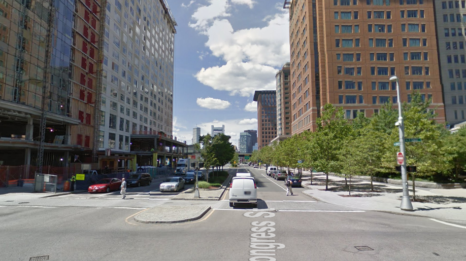
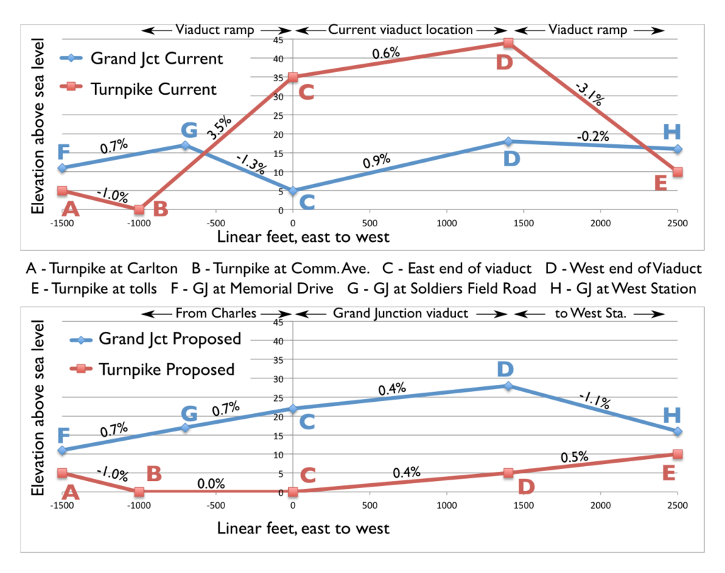
What’s more, on the eastern end of the project area, the Turnpike passes underneath Commonwealth Avenue, while the Grand Junction passes over Soldiers Field Road. 1000 feet out from the narrowest part of the corridor, where one has to pass over the other, the Grand Junction line is 16 feet higher than the Turnpike. Yet the railroad slopes down and the Turnpike ramps up, as they zigzag in vertical space to attain the necessary grade separation. From a terrain standpoint, putting the Turnpike at ground level just makes sense.

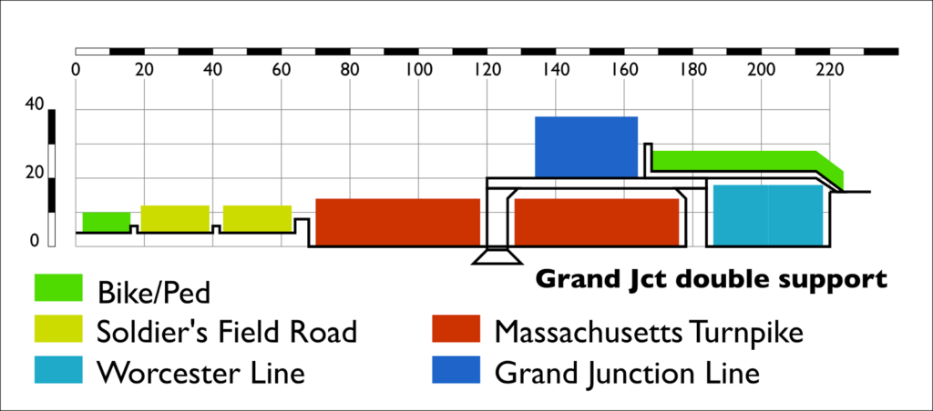
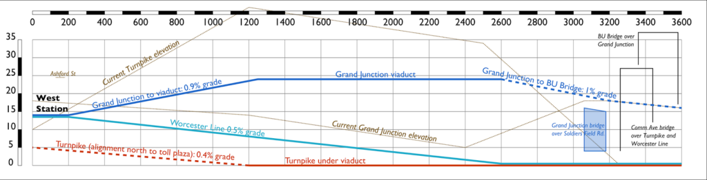
In the current setup, coming from Cambridge, the Grand Junction ascends to cross Soldier’s Field Road, and then descends sharply at a 1.3% grade to move under the viaduct. The roadway, on the other hand, ascends at a 3.5% grade to the viaduct, and then nearly as sharply at the other end to reach the toll plaza. This results in limited sight lines on the Turnpike. In the proposed Grand Junction viaduct, the ruling grade of both the road and the rail line is reduced; the rail line requires a 1.1% grade towards West Station (although this could be mitigated by slightly raising the elevation of the Worcester Line tracks), still better than the current 1.3%. And the highway has no grade steeper than 0.5% west of Comm Ave, where before it was seven times as steep, improving sight lines and safety.

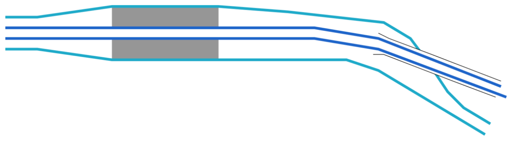
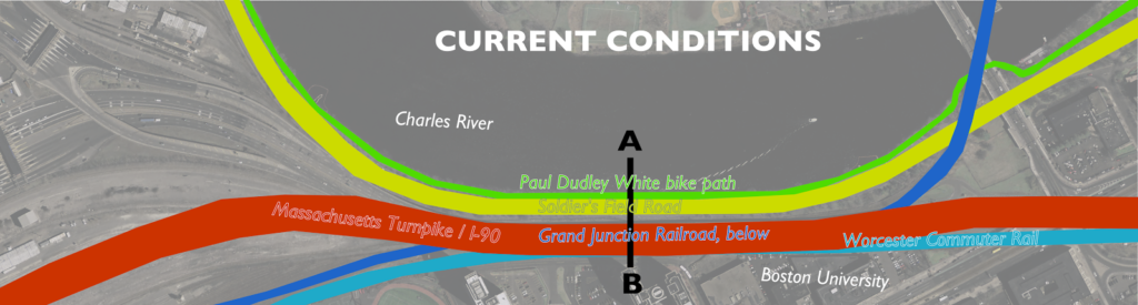
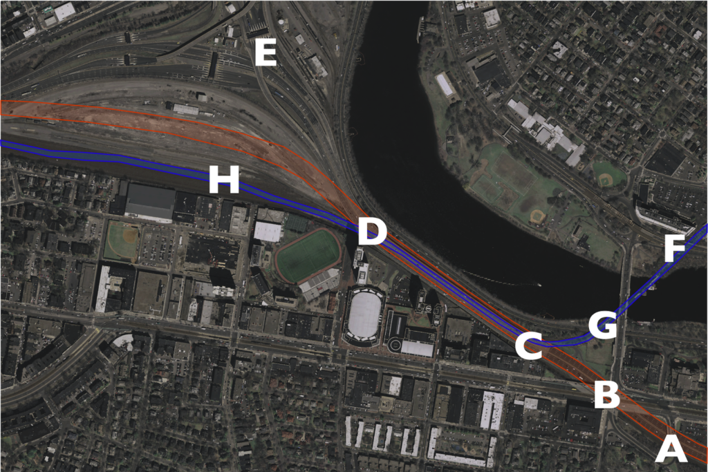
The charts below show the gradients for the current and proposed scenarios. The map below corresponds which each of the letters shown on the charts (data from MassGIS LiDAR data). Note how the Turnpike starts and ends at a lower elevation than the railroad. It makes no sense to have it resemble a rollercoaster.

What we have right now is a half-mile-long, eight-lane-wide viaduct to cross a double-track railroad right of way. It’s as if a highway were tunneled under a small stream instead of going over it on a small bridge. For whatever reason, a highway viaduct may have made sense in 1962. It doesn’t today.

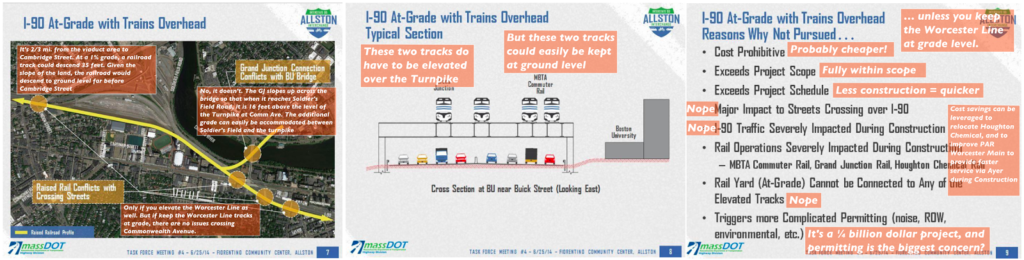
MassDOT “considered” elevating the railroad, but they dismissed it as infeasible. Why? Because they assumed that all four tracks of the railroad would have to be elevated. I don’t think it’s nefarious; I think everyone’s mindset is that the highway has to go over the railroad, because that’s how it’s always been. But the Worcester tracks stay on the same side of the highway as the whole way: they can stay at ground level; there’s no need for grade separation. The Grand Junction is much easier to elevate, and requires a much narrower structure, too. Here are three slides (from here) dismissing the overhead rail line as impossible, and my annotation on each as to why it is not the case. (Click here for full size.)

One issue is that MassDOT “requires” 135 feet of highway width for full-width shoulders. While this is “Interstate standard,” waivers can be granted for constrained areas, and much of the Turnpike (including the existing viaduct) doesn’t have any such lanes. If the highway is kept at grade, it will have much gentler grades and better sight lines. This added safety will mitigate the narrow width—and such a compromise would allow for better use of the corridor as a whole.

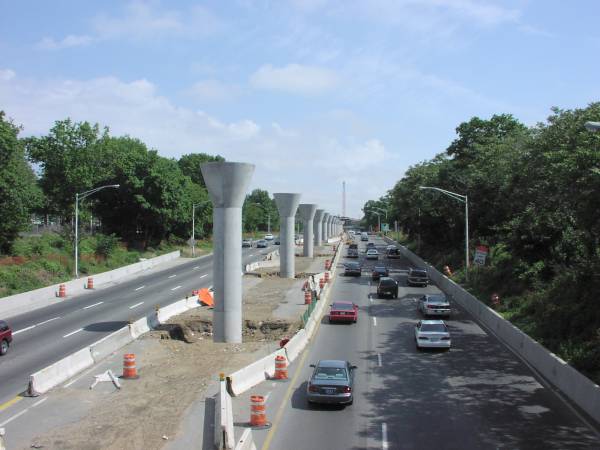
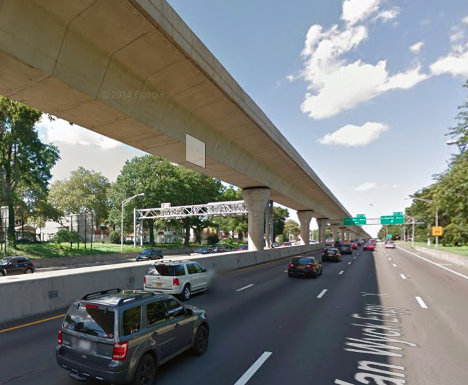
So you should kee the Grand Junction line high, and the highway low. Westbound drivers would cross under Commonwealth Avenue and then stay level. From their right, the Grand Junction line would ascend slightly—about 5 feet at a 1Ëš grade—and pass on to pedestals over the center of the highway. It would continue down the center until it curved off to the left towards West Station and descended to grade. This is not a novel concept: the JFK AirTrain in New York operates in a similar manner in median of the Van Wyck Expressway. And since initial foundation work could be completed under the existing overpass early in the project, the bottoms of the pedestals and median could be pre-built with minimal impacts to traffic; less of an impact than shown here. One note: the AirTrain uses lighter vehicles than the Grand Junction, so it may require more closely-spaced supports and a somewhat thicker deck akin to what is used for other “modern” T bridges like the Eastern Route crossing of the Mystic River.  (The photo on the right is of construction of the Van Wyck AirTrain, from this site.)

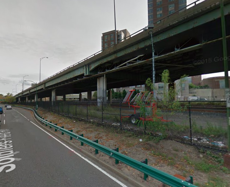
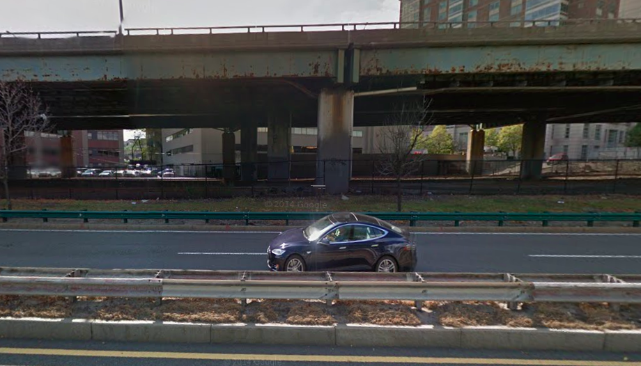
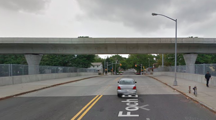
Which of the following is more inviting?

Since the AirTrain is elevated above cross streets as well, it’s quite a bit higher than a viaduct would be in Allston, what a cross-section would look like from the Paul Dudley White Bike Path is similar to what it looks like when it crosses a cross street. That’s a bit less obtrusive than this. Or see below:

The photos above are actually taken from approximately the same distance away. Note how much more of the sky you can see above the Van Wyck. Wouldn’t you rather have something like the image on the right?

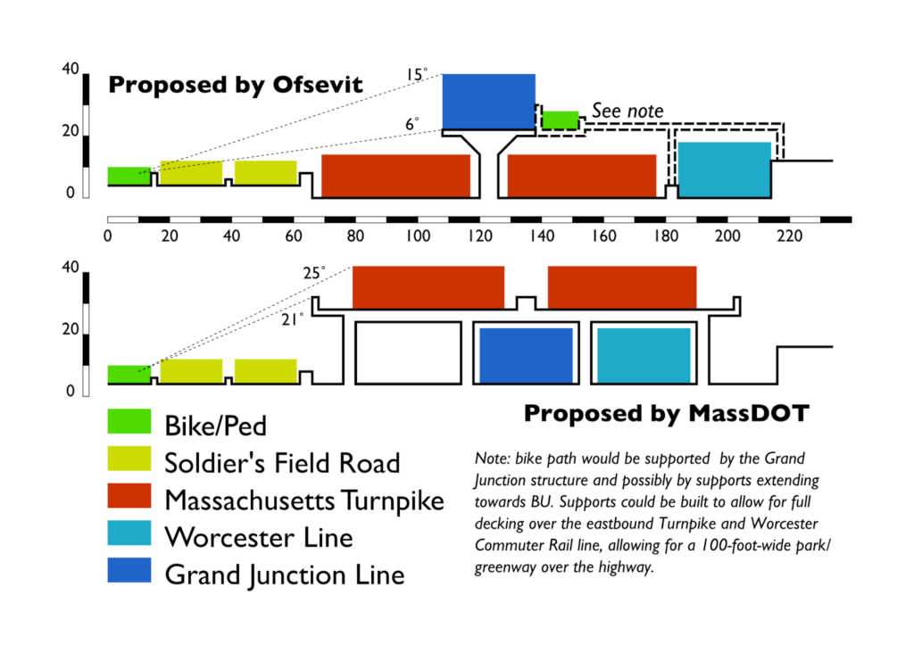
Not only is it one third the width, but it appears (and, in fact, is) lower for two reasons. In the nearby Prudential Tunnel, roads require about 14’3″ feet of clearance, trains 16’9″, so a road viaduct over a rail line is higher than the other way around. Second, trains don’t require guard rails. Put together, these add up to the top of the structure being six or seven feet lower for a rail structure. Much like how the Somerville Community Path is being built as part of the Green Line Extension, the “People’s Pike” path, it could cantilevered off the side of the Grand Junction viaduct (with additional support extending to the higher ground in—and connections to—Allston, if necessary). For an observer standing on the Paul Dudley White bike path, a rail viaduct in the median of the highway would be visible up to 6Ëš in the sky, and 15Ëš when a train passed over. By matching the initial grades, the highway can be lower than the Grand Junction since they don’t have to swap positions. The nearer and higher highway alternative would be visible in 20Ëš of the sky, and 25˚—nearly a third of the way to vertical—when traffic is taken in to account. The smaller rail viaduct would cast many fewer shadows across the bike path and river as well.

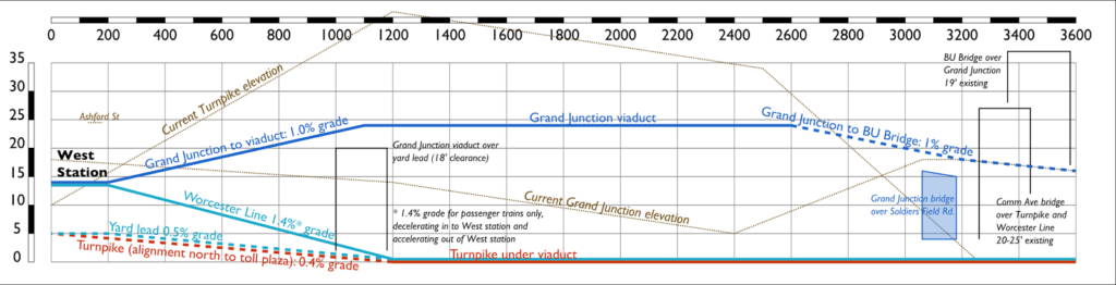
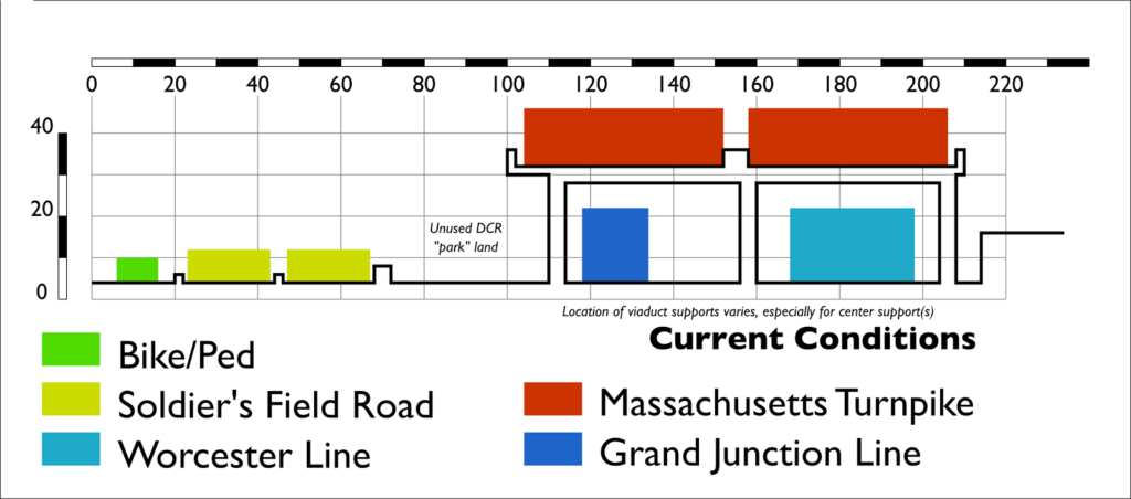
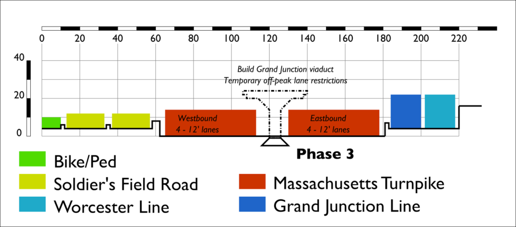
Here is a cross section of my plans and the viaduct plan. Colors denote uses, and are scaled to the height of the users/vehicles. Scale in feet:

By elevating the Grand Junction, there is enough room for the rest of the uses:

  • 14 feet for the Paul Dudley White path (an increase from 8 to 10 feet now, narrower in places)
  • 24 feet for each side of Soldier’s Field Road, with a two foot median and two feet separating the bike path. This is the current width, and the road would need little modification overall.
  • A four-foot barrier between Soldier’s Field Road and the Turnpike.
  • 54 feet of travel space for each side of the Turnpike, enough for four twelve-foot lanes, a two foot left shoulder and a four foot right shoulder, with a six foot median where the supports for the rail line sit. Including barriers, this is 11 feet more than the current 107-foot-wide viaduct, although it is not as wide as the proposed MassDOT viaduct with full shoulders. However, by mitigating the steep grades and sight line issues, the road could be designed in this section with these narrower shoulders. With 11 foot lanes, an 8 foot shoulder could be accommodated.
  • Six feet for the concrete pedestal supports for the box-girder structure for the Grand Junction rail line, which is 30 feet wide.
  • 30 feet for the Worcester Line right of way, which would be relocated only slightly once the viaduct abutments are removed.

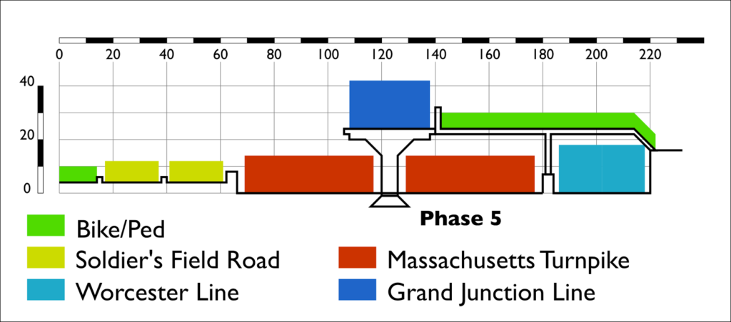
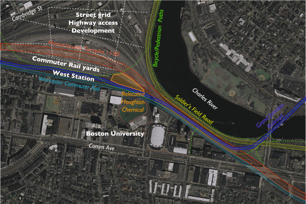
From above, it would look something like this (with just a sketch of ramps and street grid in Allston, which would built above grade):

And a focus in on the narrow viaduct area:

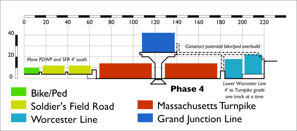
It would also have benefits in the Allston area. In current plans, the Turnpike viaduct has to slope gradually down through the Beacon Park Yard area. If it were at grade, it could be easily decked over, and ramps could go up to a street grid on that deck. The Grand Junction would have to descend towards West Station, but it has a much smaller footprint and would start its descent from a lower elevation, thus it would much more easily integrate in to the surrounding area.

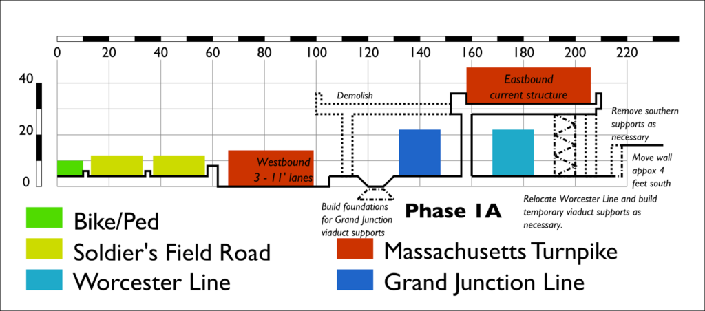
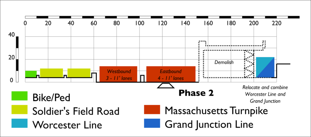
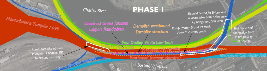
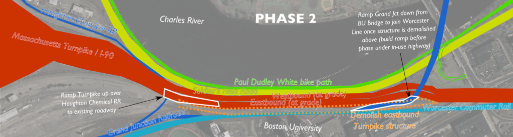
Construction would also be much simpler, because instead of a multi-stage process where the viaduct was unbuilt and rebuilt at the same time, it would simply be unbuilt in stages, with the new roadway built on the ground below. The current staging plans call for a new, wider viaduct to be built in stages, two lanes at a time, while the old bridge is being torn down, including many temporary supports and other engineering issues. By putting roadways at the surface, you could accomplish the entire task without building any new bridging, in fewer stages (dismantling four lanes at a time instead of two), and only shoring up a few supports temporarily. It’s even possible that pedestals for the Grand Junction—which would likely be built under the current viaduct before other construction—could be used during construction to shore up the viaduct as it is dismantled.

As for the final product, rather than a 110-foot-wide, 30-foot-high viaduct, you’d have a 30-foot-wide, 24-foot-high one. The rail structure would have just 22% of the mass of the road viaduct. Road noise would be lower to the ground (with the potential for an overbuild park to cap noise all together), and the viaduct would be further from the river and from buildings at BU. And ongoing maintenance costs would be far lower. The main loss is the inability to tuck some of Soldier’s Field Road under the viaduct and create slightly more parkland in the vicinity of the viaduct. But for a cheaper project, you get a much smaller viaduct which casts fewer shadows over this area, so the bike path is a more pleasant experience.

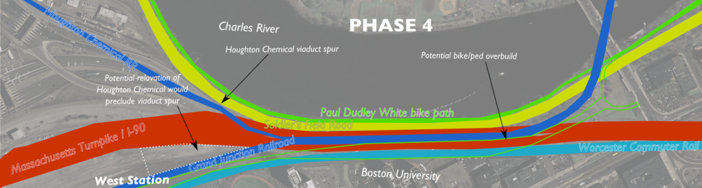
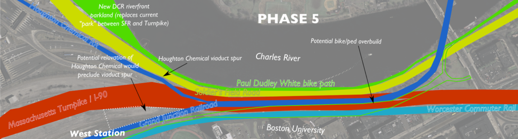
The only major issue would be a relatively long-term closure of the Grand Junction branch, so MBTA operations and a small amount of Everett-bound freight would have to move via Ayer and Worcester. This happened recently when the Grand Junction bridge was undergoing emergency rehabilitation for several months; the biggest issue was the 10 mph speed limit on Pan Am trackage between Ayer and Worcester. (The railroad out to Worcester is Class 3 and permits 60 mph speeds, the rebuilt railroad inbound from Ayer will mostly be Class 4 with speeds of 80 mph.) With a small portion of the money saved from not building a road viaduct, that track could be upgraded to Class 2 (30 mph) trackage to save considerable time with equipment swaps and improve a freight rail trunk line as well. It would also be an opportunity to fully rebuild the Grand Junction bridge, and other portions of the corridor to Kendall Square and beyond. (One other minor issue is serving Houghton Chemical, which could be accomplished, by relocating Houghton Chemical to the other side of the highway as depicted above. In the “armpit” of the Turnpike and railroad, it would be a perfectly good site for such a use, sustain a family business in the area, and free up developable land near the river.)

Once you take a step back from the current situation and think about this, it’s obvious. It makes no sense to build a wider, higher viaduct for a roadway when you can build a narrower and lower one for the railroad. All it requires is some grading underneath the viaduct, construction that is certainly no more complex that what is being proposed. A surface roadway has a much longer lifespan and lower maintenance costs than an elevated one, and it provides a much less obtrusive—and more future-proof, as it fits in better with potential development in Allston—structure as well. It’s a better project. Best of all, given the cost differentials for projects like the Casey Overpass elimination (and McGrath and Bowker), it could probably be built for $50 to $100 million less than the viaduct, with future savings from lower maintenance costs.

That money would go a long way towards full completion of this project, mitigation steps, and ensuring the safety of other roads and bridges across the Commonwealth.

Comments on Allston

Harry Mattison, who’s leading the charge regarding the Mass Pike realignment that has been discussed for some time, asked me to reply to his email chain with some comments. I figured I’d post them here. This is what I think about the project and comments I will be submitting. Most of it is aligned with what the rest of the committee is pushing, with a bit at the end echoing some earlier ideas I’ve had. In any case, the more they hear from the public, the better, so please send comments to:

dot.feedback.highway@state.ma.us

by the close of business on Monday, September 29. You can find another example letter here.

*****

I am writing regarding the continuing planning process for the Allston Interchange project. While the project plans have certainly progressed from the originally-proposed “suburban-style interchange” (which seemed specious at the time and hopefully wasn’t a red herring to make urbanists feel like MassDOT was committed making changes), there is much work to be done. My comments will focus on several areas—overall design, development potential, transit use, bicycling and pedestrian connections and parkland—to assure that the highway utility is maintained but that this project is a positive development for the surrounding community. This is a once-in-a-lifetime opportunity to remake this parcel of land, and to connect Cambridge, Allston, Boston University and surrounding communities. Failing to do so will be a failure of the planning process, and a dereliction of duty for MassDOT in its GreenDOT, Health Transportation Compact and overall mode shift goals.

The overall design of the project as an urban-style interchange is certainly better than high, looping suburban ramps, but it has room for improvement. The footprint of the project, both in its width and height, must be minimized. For the width, a highway with “interstate standards” has been proposed for the viaduct section, with 12 foot breakdown lanes and a much wider viaduct looming over the Charles, and engineers argue that this is a requirement. This is risible. Much of the Central Artery project lacks such lanes, as does the current structure. It will certainly be less costly to build a narrower structure with less material (savings that could be used for other area improvements), and traffic and congestion in the area is caused by many factors, none of which is the width of this structure. The current structure should be the maximum width of the new project, not the minimum. West of the viaduct, the current proposal should be modified to assure that the maximum amount of the highway is built at or below grade to allow overhead use in the future. All surface streets should be built as city streets, with single turn lanes, low design speeds and provisions for bicycles, pedestrians and transit use.

Finally, the project team must have direct input from the planning, architecture and landscape architecture fields, with a focus on the emerging “placemaking” field. Even with changes, it seems that this is being viewed first and foremost as a highway project. It must be viewed as an economic development project, which happens to have a highway running through it.

It is very important that whatever the design of the final highway, it is minimally disruptive to overall development in the area. This area lies within a mile of Boston University, Harvard and MIT. It will have good highway connections, and (hopefully) excellent transit connections to much of the population and economy of Boston. The value of the land for housing, education and commercial uses will be almost unparalleled in the area, and there are certainly examples of high-value properties built overhead highways. (One must look no further than the Prudential Center for a good example.) The provisions for overhead decking should be built in to the project, if not the decking itself, which is far less expensive to build as part of a brownfield construction project than an existing highway. This decking should, if possible, extend over the rail corridor as well (Back Bay Station would be an example here, as would many New York City Transit properties). With more and more residents wanting to live in transit-accessible areas, we should assure that potential housing properties are kept as easily built as possible.

As this area grows, it could become the next Kendall Square: a nexus of education and technology. Currently, the rail yards and highway produce minimal tax revenue for the City of Boston, which has to deal with the air and noise pollution they create. Allowing maximum development potential here should be a priority for the Commonwealth, to allow the city future tax revenues from development here. Cambridge residents enjoy low property tax rates due to the many businesses in the Kendall Square area; extending this to Allston would benefit all of the residents of the city. Many international companies have relocated to Boston and Cambridge, and we should give them every opportunity and location to do so. The Boston Society of Architects has had some great examples of this type of development potential here.

Transit must be a priority for this project, not an afterthought. The oft-mentioned West Station should not merely be a design element of this project, it should be built as part of the project, if not before the mainline of the roadway. Further development of this area will not take place because of its proximity to a highway; transit access will drive growth in the 21st century. West Station must be built with a minimum of four rail tracks to serve both the burgeoning Worcester Line as well as potential service on the Grand Junction. The state is spending millions of dollars improving Worcester service and expanding the number of trains, and a West Station service current uses (steps from Boston University) and future growth is a must. The Grand Junction Line must be built with two full tracks for potential future service; it’s ability to link Allston, Cambridge, North Station and beyond (and by doing so, provide much better connections for travelers from west of Boston wishing to get to Cambridge, the cause of much of the surface traffic in the area) should not be understated.

In addition, the plans must have provisions for future north-south transit in the area. Currently, travel from Boston University to Harvard Square requires 40 minutes and a minimum of one transfer, often with travel through the congested center of the subway network. New traffic patterns should allow for a direct connection between BU and Allston, continuing on the south end to Kenmore Square or the Longwood Medical Area, and the north side to Harvard Square. While there are certainly valid arguments that heavy car traffic should be precluded from this area, transit service should be prioritized. A transitway from the Packards Corner area via West Station to Harvard Street would fulfill objectives of the Urban Ring, as well as allow much better connectivity through the neighborhood. This should be planned with signal priority over other vehicular traffic, the potential for future grade separation, and the potential for conversion to light rail so as to meet up with the Green Line on Commonwealth Avenue. Imagine, a Green Line branch from Cleveland Circle to Harvard Square via Commonwealth Avenue and Allston. This would certainly be possible in the future if we design the appropriate rights of way today.

In addition to transit, bicycle and pedestrian travel must be well-integrated in to the project. The recent concepts put forth have certainly improved original plans, but, again, bicycle and pedestrian infrastructure should be a priority, not an afterthought. Pains should be taken to assure that routes are safe, adequately wide (a minimum of 25 feet wherever possible) and direct, with minimal street crossings. A well-built bicycle and pedestrian network will make trips which are currently convoluted, roundabout and/or dangerous much more desirable, and certainly allow for better connectivity and attaining mode shift goals by shifting travelers away from cars. Other existing and future human-scale corridors should be designed for maximum efficiency in moving people without cars. Within a 30 minute walk of this area are many of the leading health, education, science and commercial institutions in the world. They should be accessible without sitting in traffic.

This project parallels the Charles River, and surround park land must be a priority. From the Charles Dam to the Eliot Bridge and beyond, much of the DCR parkland is taken up by high speed roadways. We have turned our back on the river in the name of moving vehicles, and this is something we should begin to take steps towards mitigating. This project will give us a good first stab at that. As mentioned above, no parkland should be sacrificed for a wider viaduct: we have seen too much green space appropriated as pavement in the past generations. Soldiers Field Road should be migrated as far away from the river as possible, creating a promenade or “Allston Esplanade” similar to what we have further to the east, which should connect with development alongside and above the highway. The current bike path, which is, at places such as the River Street Bridge, less than five feet wide (well below any reasonable safety standard) in the name of keeping car traffic moving must be changed: we should no longer throw the safety of cyclists and pedestrians to the wind in order to make traffic flow better. It is laudable that MassDOT is working with the DCR: they should be included in this process going forward.

Furthermore, there is a dramatic opportunity to work with Harvard to move Soldiers Field Road away from the river across a much longer distance, and in turn create one of the premiere riverfront parks in the country. This would entail looping Soldiers Field Road west of Harvard’s Business School campus and the Harvard Stadium, likely in a below-grade facility to mitigate the impact on the neighborhood there. However, without sacrificing any capacity and allowing shorter distances for motorists, it would allow the DCR to decommission the roadway between the Eliot Bridge and the Allston project site, allowing a wide, linear park to form along the river, benefiting not only local residents, but all residents of the Commonwealth. (A rough outline of this plan can be found here.)

The Allston Turnpike project is an opportunity to shape the entire region for the next 100 years. We must assure that all plans allow for the maximum future development. Again, this is not merely a highway project: it is a long term development project which we must allow to have positive returns for the Commonwealth’s economy and quality of life.

No need to duplicate transit on Comm Ave

NB: This got picked up on Universal Hub and there are a bunch of comments there. I’ll respond to comments in both forums, but probably here more. One note of clarification: I’m not saying that this should be the plan, but that it should be considered. Like much of the Commonwealth Avenue project, the planning process has been opaque and has had no public input. Also, this comment is a great illustration of what you could have.

The Boston Globe recently ran a story about proposed changes to Commonwealth Avenue. Of issue is that while Comm Ave is wide, it is not infinitely wide, and the changes will widen the transit reservation (mainly for safety for track workers, presumably this would also allow for wider stations), narrowing the rest of the road enough that the city is reticent to add cycle tracks, because it would narrow bus stops, and stopped buses would delay vehicles. (I’m just going to touch on the fact that there really shouldn’t be an issue with delaying traffic in favor of buses, bicyclists and pedestrians, but that’s not the scope of this post.)

What I am going to point out is that all of these issues could be mitigated by moving the 57 bus route and the BU buses to the center reservation of Comm Ave with the trolley tracks. This would result in the removal of bus infrastructure from the sides of the street—buses could instead stop at the same stations as Green Line trains. While this would be novel for Boston, it has been used in other cities, and while it could result in delays for transit riders, with better stations and transit signal priority, it would result in a better experience for all customers.

There are a variety of benefits from such a plan:

  •  Buses would move out of mixed traffic, resulting in fewer traffic delays for buses (especially at the busy BU Bridge intersection) and fewer conflicts between buses and traffic.
  • The duplicative infrastructure of having parallel bus and trolley stops would be eliminated. In their place, larger, more substantial stations could be built in the center transit median.
  • Instead of waiting for either a bus or a trolley, riders could board “whatever comes first” for short trips between Packards Corner and Kenmore Square, and riders wishing to go further east than Kenmore could take a bus to Kenmore and transfer down to a B, C or D car.
  • Removing bus stops would eliminate the conflict with buses pulling across the bike lanes when entering and exiting stops.
  • Removing bus stops would allow for more parking spaces to be added to the street. The number would be small—probably in the 12 to 18 range—but not negligible, and would assuage the (dubious) constant calls for more parking in the area.
  • In addition, there would no longer be issues with cars and taxicabs blocking bus stops, requiring buses to stop in the travel lanes.
  • Wider stations would better serve disabled users, with higher platforms better allowing wheelchairs and other disabled users to board and alight transit vehicles.
  • Narrower side lanes (parked cars are narrower than buses) would allow for more bicycle and sidewalk space, including the possibility of cycle tracks.
  • Without bus stops, there would be no need for bus passengers to get off of buses and cross a cycling facility.
  • With signal priority implemented, transit travel times through the corridor could be improved for bus and trolley riders.

The main reason to not to do this is that it hasn’t been done before. The cost to pave the trackbed—and to pave it well—wouldn’t be negligible, but since the entire corridor is under construction, it would be feasible. There would have to be some study to see if the number of vehicles would cause congestion in the transit reservation.

Additionally, there would have to be a specific signal to allow buses to enter and leave the corridor at each end of the corridor—especially the east end where they would have to merge back in to traffic. However, the 57 bus would only have to merge in to and out of the left lane since it then accesses the busway at Kenmore, which is in the center of the roadway. This could be attained with a signal activated by the approaching vehicle—again, a novelty in Boston, but by no means a procedure without global precedent.

The B line has 26,000 surface boardings, most of which travel to Boston University or through the campus and in to the tunnel. The 57 bus adds 10,000 more, and the BU Bus serves countless others. There are tens of thousands of pedestrians in the corridor, and thousands of bicyclists—it is one of the most heavily-traveled bicycle corridors in the city. Yet we are planning for cars—minority users of the corridor—first, when we should be planning for transit first (by far the largest user of the corridor by the number of passengers carried), then bicyclists and pedestrians. Cars should be an afterthought, put in to the plans after other users have been accommodated, not before. Of course, had the old A line never been converted to buses, Commonwealth Avenue would not host any MBTA services, and wouldn’t need any bus infrastructure. But that battle was lost 45 years ago.