What’s up with the taxi queue at Logan?

Early Monday morning, on Twitter, Cambridge City Councilor Jan Devereux posted this photo of the taxicab line at Logan Airport:

Then she went to check out the Uber/Lyft line and it was no better:

By 1:30, others reported that the cab line was an hour long.

What’s going on here? Where are all the taxis? Where are all the Ubers? Why are people arriving at the airport after midnight then waiting an hour for a ride home? What can we do about this?

It’s not really a simple answer. Please, though, follow me down a rabbit hole.

Logan airport is not a hub airport (okay, not really: Delta and especially JetBlue are doing their best to create a hub, but it still is mostly an origin-destination airport). This is a matter of geography: because it is tucked away at the northeast corner of the country, the airport mostly handles passengers flying in one direction, south or west, either on direct flights, or to other domestic hubs (although international travel has increased markedly in recent years, and JetBlue even has a bank of later domestic flights to accommodate connecting passengers).

Boston’s flights can be grouped in to three main types: short haul flights to non-hub cities, short-haul flights to hub cities, and long hauls, both domestic and international. Only the first group operates without geographic constraints which dictate that flights can only arrive and depart at certain times of day. Non-hub short-haul flights, mostly on JetBlue and Delta (to places like AUS, BUF, RDU, MKE) are spread more evenly throughout the day, because they don’t have to make connections at hubs. Hub-based flights within the eastern half of the United States (say, as far as MIA, DFW and MSP). These flights account for many of the early departures, but few leave Boston after early evening. They don’t arrive in Boston until mid-morning, but are the bulk of the last flights arriving later in the evening. Because of these travel patterns, Logan has a lot of early and late flights: in the morning, people want to get to a connecting hub for the first “bank” of connecting flights, and in the evening, flights have to leave the connecting hub after the last bank has occurred.

(Not all airlines utilize banking at hubs—Southwest most notably runs continuous hubs—and there are pluses and minuses to each method, about which I won’t go into too much depth here. But basically, banking decreases fleet utilization and increases congestion at hub airports since flights arrive and depart all at the same time, followed, in some cases, by periods of relatively low flight activity, but passengers have much shorter connection times at hubs since connections are coordinated. It’s actually something like a pulse system for buses, except that airports have finite numbers of vehicles which can arrive and depart at any given time, and longer dwell times. As airlines have consolidated, hubs have grown and seen more frequent banks such that they are now closer to continuous operation, especially at large airports like Atlanta and Chicago. See how this is a rabbit hole? Also, when I say people want to connect to the first bank, I mostly mean airlines, no rational human being wants to be on a flight departing at 5:15 a.m.)

Then there are longer-haul flights. Transcons have to deal with time changes, cycle times, and the fact that flights generally don’t depart or arrive between 1 a.m. and 5 a.m. local time. So they arrive from the West Coast either as redeyes between 5 and 10 a.m., and then turn to depart between 6 and noon, or as day flights, arriving in the afternoon or evening. Thus, in addition to the overnight lull, there are basically no transcons which arrive in or depart Boston during the midday. International flights (mostly TATLs) generally are redeye flights going out, leaving Boston in the evening, and return during the middle of the day, arriving in the afternoon. All told, Boston has demand throughout the day, but particularly high demand for flights arriving later in the evening.

For instance, O’Hare and Atlanta, the two busiest airports in the country (by number of aircraft movements), have 29 and 24 flights scheduled to arrive after 11 p.m., respectively. Boston has 39. After 11 p.m., Boston is basically the busiest passenger airport in the country (about tied with LAX), and possibly the world (since in many countries, airports have noise regulations which limit late night flights). Yet at the same time, there are few flights departing Boston. The airport has only 14 scheduled departures after 11 p.m., and only six of these are domestic flights (all are JetBlue E190s, so they’re small planes). There is basically zero demand for passengers to get to the airport late at night. This creates a demand imbalance for ground transportation: there’s a lot of demand to leave the airport at midnight, but almost no one who wants to go there.

Here are some charts of the approximate number of airline seats arriving and leaving Boston. I adjusted for the typical arrival time at the airport (60 minutes for domestic, 120 for international) and assumed it would take 30 minutes for the average international passenger to clear customs.

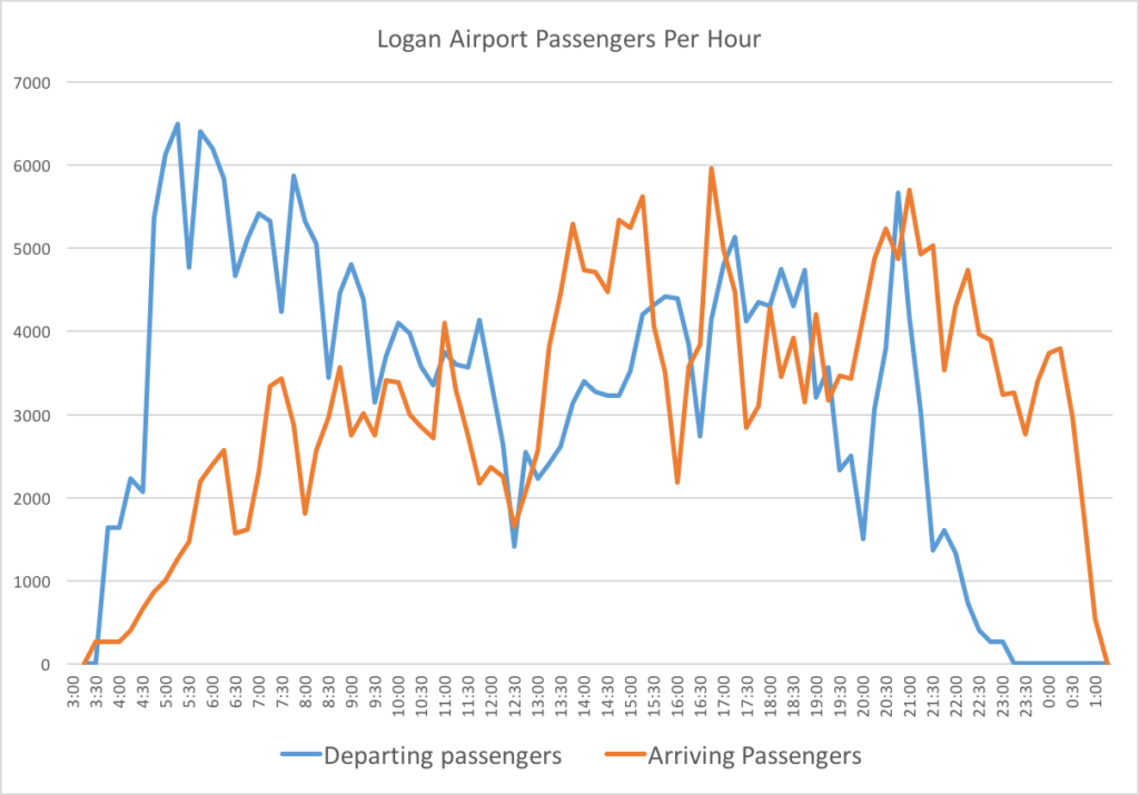
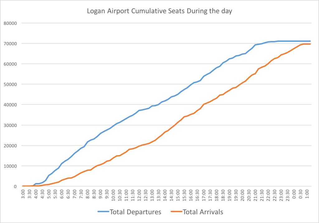
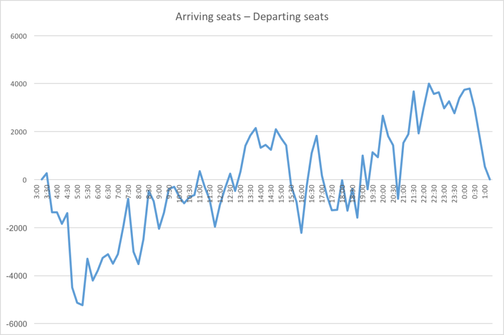
(Note, the seat numbers for arrivals and departures don’t exactly match because each day at Logan is not identical and this was a snapshot of a day. This is total seats available, not total passengers, and is also a rough estimate based on plane sizes at different times of day, but should show general trends well.)

So, it’s clear that there is a good deal more demand to get to the airport in the morning, which doesn’t even out until around 9 a.m., various points of imbalance during the day, and then, starting around 7 p.m., significantly more demand to leave the airport.

A couple of personal anecdotes can illustrate this. The first illustrates the imabalce in the morning. Back before the Big Dig was completed (and, in fact, pre-Silver Line, and back when the airport had half the traffic it has today), when I was going to college, getting to the airport was, perhaps, worse than today. It involved both the elevated Central Artery and then the Sumner/Callahan tunnel complex: a trip to or from the airport to downtown could take an hour (which is, of course, not much different than it is now). For several years, however, the Ted Williams Tunnel had been open to commercial vehicles only. The connecting highways were not yet complete, so this was a way to keep the local streets from getting overrun by people trying avoid the congestion.

From Newton, where I grew up, my father came up with a solution, especially for early morning departures. He would drive me to South Station. Rather than risk the airport traffic, I’d get in a cab for the usually $10 or $12 trip under the harbor in the tunnel only cabs could use. Early one morning, I got in a cab at South Station and told the driver I was going to the airport. He quoted the fare: “$20” and didn’t turn on the meter. What I should have done is say “I’ll pay you whatever the meter quotes at the end of the ride, so it’s in your best interest to turn it on now,” but I was 18 and hadn’t quite figured that out, so at the airport, I paid him $20, noted his medallion number, and immediately reported it.

A month later my dad got a check for $20 from the Boston Police (which oversee taxi medallions), along with a note that the taxi driver had been given a stern talking to that he was never to refuse to turn on the meter for a trip within the city.

But I understand why the driver was reticent to take the fare. He would get to the airport and have two (bad) decisions. One would be to go to the taxi pool and wait in line for an fare back to the city: a long line, because there is much less demand going in to the city at 7 a.m. than there are taxis arriving at the airport. The other would be go cross back downtown without a passenger, but still incur the cost of driving, as well as the tunnel toll (which was one-way inbound at that point), with no passenger to pay it. Still, because of redeye arrivals from the West Coast in the morning, there is some traffic for cabs that do make it to the airport going back, although they have to cycle through the cab pool (or the Uber/Lyft pool) before their next fare. Even now, if you take a cab or a ride-hail vehicle to the airport in the morning, the driver is probably not particularly happy taking the fare.

The second example was an extreme example of the late-night issue. I was flying back from SLC and the flight was delayed several hours. Originally scheduled in at 11:30 (plenty of time to catch the Silver Line downtown and take the T home), the plane was more than three hours late, and didn’t arrive in Boston until about 2:30. The airport was empty. Yet a 757 had arrived with 200 passengers, and no one was making the trip at that point to pick us up. So we all converged on the cab stand, but there wasn’t a cab in sight. Immediately, people started self-pooling: it was clear that if we all took our own cabs, the line wouldn’t clear for hours. “Who’s going to Brookline?” “I’m going to JP, that’s close!” “I’m going to Concord.” “I’m going to Lexington, let’s share.” Every few minutes, a stray cab would roll up, three overtired strangers would pile in, and the line would get slightly shorter. I found a cab pretty quickly, but imagine those at the back of the line may have seen the sun rise.

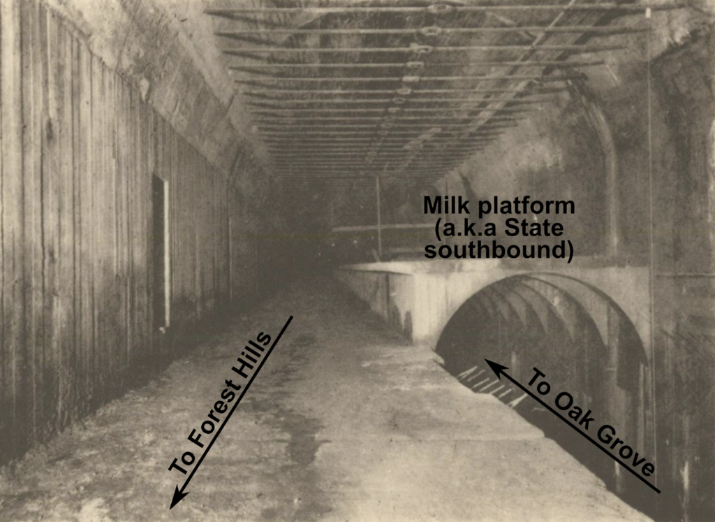
Finally, here’s a picture of the departures level at Terminal A at 8 p.m. this past week.

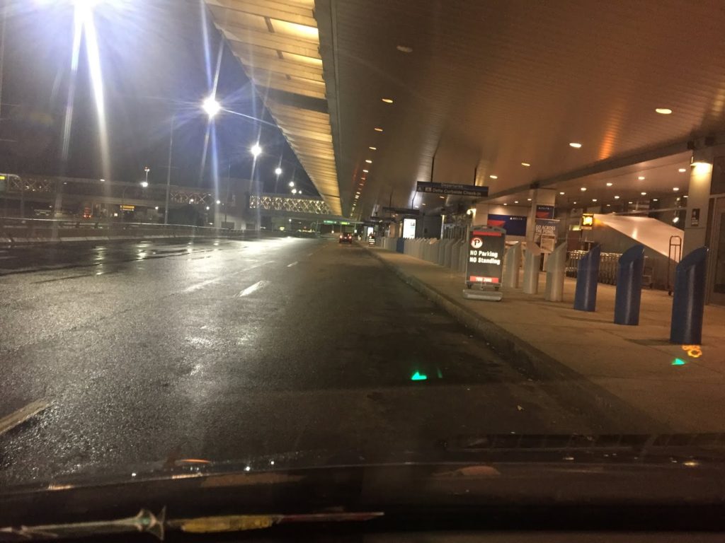
Delta’s last domestic flight leaves at 7:45 (to MCO) and the last hub-based flight leaves at 6:56 (for ATL). Two international flights leave around 8:30. At this time, it’s a ghost town. Note: if you’re picking someone up at the airport in the evening, plan to meet them on the upper level, and note that Terminal A is a great place to wait without having State Police harass you. (Terminal B was pretty quiet, too.)

Here are scheduled arrivals and departures, by carrier, at different times of day:

Note: not all regional flights appear to be in this sample, for instance, there are no Cape Air flights shown after mid-evening, when Cape Air flies several late flights out of Boston, but these flights are minimal as far as number of arriving passengers is concerned.

Notice how departures peak in the morning, then lull in the midday, and then have a secondary peak in the evening, before domestic departures (except for JetBlue) tail off quickly after 7 p.m. International carrier flights are clustered arriving in the afternoon and leaving in the evening. But there is a clear imbalance for flights arriving and departing the airport.

In any case, this has been a problem for years, and it’s a structural issue pertinent to Logan Airport based on the airport’s geography on both a macro and micro scale. On a macro scale, the geography of the airport at the corner of the country means that, late in the evening, flights feed into it but don’t feed out. On a micro scale, the airport’s geography encourages taxi/app-ride/ride-hail use (I’ll call these taxis, for simplicity). The constrained location means that parking costs are high, because demand for parking outstrips supply. The proximity to areas with high trip generation (downtown, and high density areas nearby) means that taxi costs are often significantly lower than a day’s parking cost ($38) in the garage. The combination of these factors push many people to use taxis.

Much of the day, taxi supply roughly matches demand, and there is a minimal delay for these services. But this breaks down at the beginning and end of the day, especially in the evening. Once again, Logan’s geography comes into play. While the airport is close to the city geographically, it is expensive to get to for a taxi driver. When there is high demand for fares back to the city at 1 a.m.—especially once buses have, for the most part, stopped running—there is negligible demand to get to the airport, or even East Boston in general, so to pick up any fare would require the driver to deadhead to the airport.

Unless a driver happens to pick up a stray fare to East Boston, this requires a driver to travel several miles, and to pay the cost of the tunnel toll. Once at the airport, there is no promise that the trip home will be lucrative enough to cover these costs. They might get a $50 fare to a far-flung suburb. But it might only be a $15 fare to a downtown hotel or, worse, to Revere or Winthrop, meaning a driver would then have to drive back home—likely through the tunnel—and foot the bill for the toll both ways. Moreover, this is the end of the day for most drivers: except on a Friday or Saturday night, there is only so much demand for rides after 1 a.m. For many drivers, the potential upside of getting a decent fare from the airport doesn’t make up for the potential downsides, especially when the alternative is shutting off the app (or taximeter), driving home, and going to bed an hour earlier. There is a high disincentive to be in the last group of taxis at the airport: a driver might get one of the last passengers, but if not, there is not likely a job for several hours when the first redeye flights start to trickle in around 4 a.m. There is little incentive for taxicab drivers to go to the airport during this dwindling time, so demand is only met by drivers already in East Boston who need a fare back to the city.

This is not an easy issue to solve. It also shows why Uber and Lyft are basically just taxis: they are subject to the same supply and demand issues that affect the rest of the market. Alas, they’re providing the same service: a chauffeured ride from Point A to Point B. And the airport is pretty much the only place that cabs still have a foothold, partially because matching passengers to specific vehicles is quite inefficient with large groups, like you might find at an airport. This has been a recent point of contention at LAX, which consolidated its taxi and ride-hail facilities away from the terminals (as Logan is planning). It hasn’t gone particularly well to start, but I would venture to guess that there are similar supply and demand issues at LAX. (As several people have pointed out, the buses there are running much more smoothly, too.)

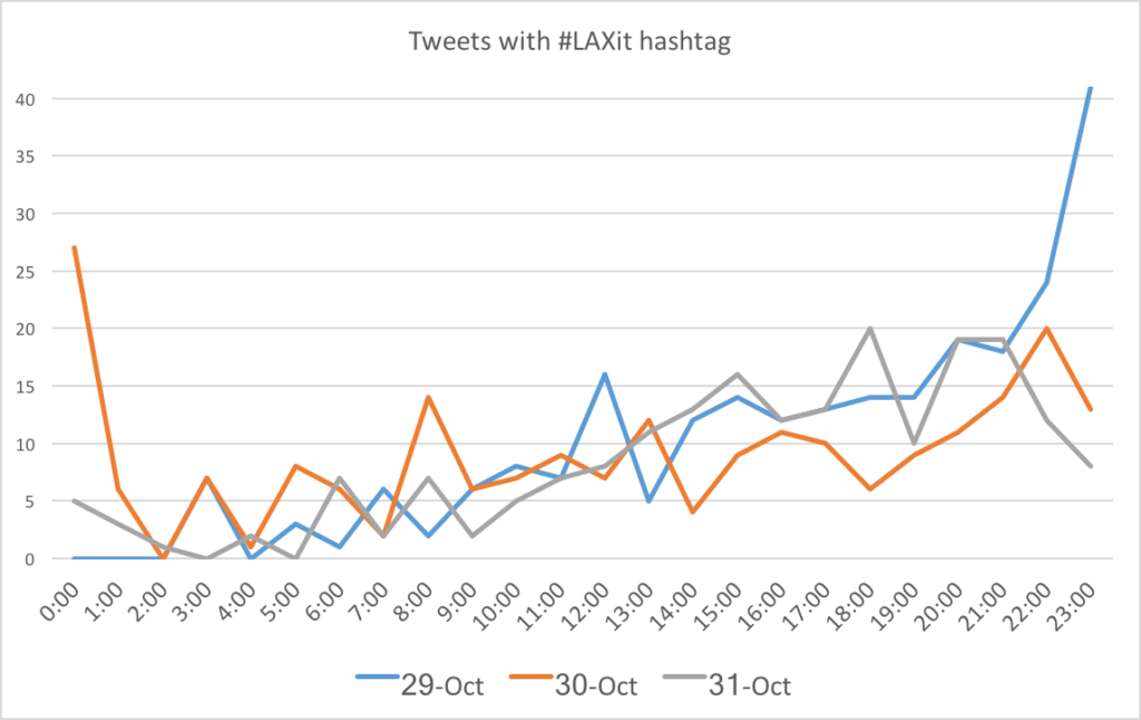
Of course, at LA, there is a temporal aspect to the complaints about #LAXit. Most of the issues are in the evening. Los Angeles has more balanced operations, with plenty of departures in the evening, both redeyes to the East Coast and transcontinentals, mostly TPACs but some TATLs as well. There is probably both more demand for cabs in the evening because LA is on the opposite side of the country as Boston, and also because most of the transcon redeyes leave before 11 p.m., and most of the later flights are international, which are fed more by connecting travelers and by passengers arriving at the airport much earlier. Thus, for the actual demand for taxis, there is a similar, if less pronounced, demand compared with Boston.

I scraped Twitter for #LAXit from the first few days and it seems clear that the issue is mostly in the evening.

But back to Boston. Here’s what the Logan cab pool Twitter feed (because of course Logan’s taxis have a Twitter feed) looked like last Sunday. There was a cab shortage by 8 p.m., and the late night arrival issue was foreseen by 10 p.m. It wasn’t a surprise. It is a market issue.

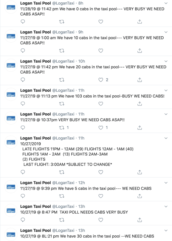
Is this feed a bot? Certainly not! Note the wrong months, typos, misspellings, random numbers of hyphens and use of quotations. The one thing that seems constant is the use of the word “need” when the airport has a cab shortage (with various qualifiers like all-caps or exclamation marks). I’m pretty sure it’s a guy standing by the taxi pool furiously typing tweets into the Twitter machine. So, I decided to scrape the feed (about 60,000 tweets), and code each tweet by whether it included the word “need” or not, to get a very rough estimate of the frequency of taxi delays at Logan.

From the charts of arrivals and departures above, we would assume that the airport would generally need cabs mid-afternoon, as well as in the evening. If we chart the arrival and departure relationship and the Twitter feed’s need for cabs together, and we shift the need for cabs back 1:15 (probably due to actual behavior of arriving passengers), voila, they match pretty darned well.

A few other notes on the need for cabs:

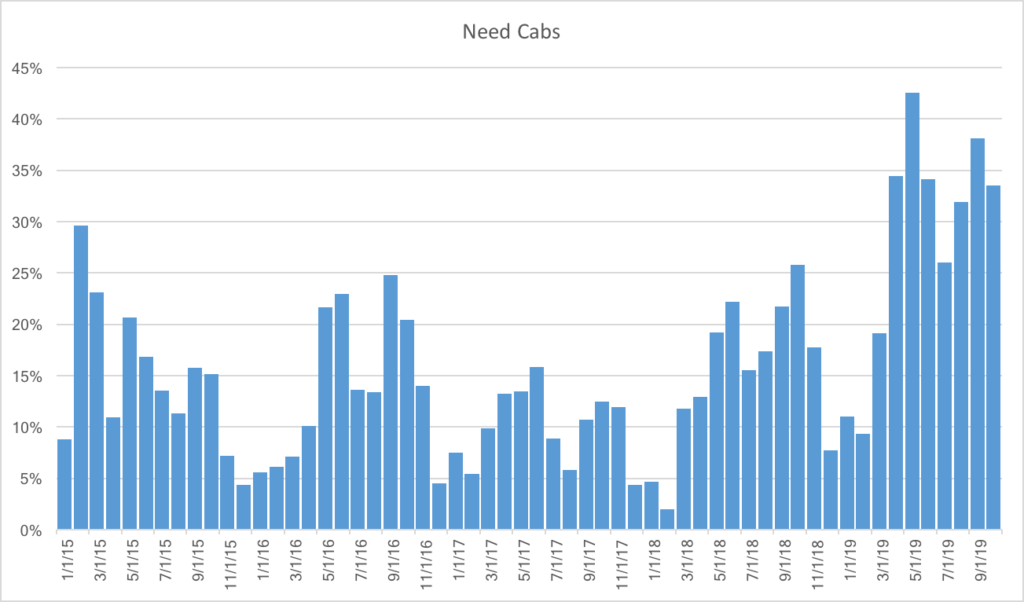
  • There is more demand on Sundays (36% of Tweets include the word “need”), followed by Mondays, Thursdays and Fridays (28%), with the least demand on Saturdays (20%)
  • The cab shortage is generally higher in the summer than the winter (and highest in May, June, September and October, while lowest in December, January and February), and it has been particularly high this year. In fact, the only higher demand for cabs at the airport was in February of 2015. I wonder why.

TL;DR: it is definitely getting harder to get a cab at the airport, especially during certain times of the year and at certain times of day. And when flights are delayed, this is exacerbated. Departing passengers generally still get to the airport on time, but arriving passengers get in later, meaning the cab shortage is even more acute. Which leads to situations like the one which occurred earlier this week at the start of this post, which may have taken you nearly that long to read

So what can be done about it? Well, Uber/Lyft could use their surge features to increase the cost of a trip to the point where it would make economic sense for drivers to come to the airport at this time of day. But that might double or triple the cost of a ride, so while it is a very market-based solution to the problem, it is not consumer-friendly. It (and taxi starters) could do a better job of pooling rides, and moving the Ubers and Lyfts to the same site might make pooling easier there. A very low-tech idea might be to figure out where vehicles are going and, at high-demand times, put people into lines based on regions to help them self-pool. This might nibble around the edges on the demand side, but it doesn’t help supply. It turns out that Lyft and Uber are not a magic panacea to mobility: they are subject to the same supply and demand issues as the rest of the world. And if the answer is pricing, it’s not a great answer, especially since prices might have to go up significantly to provide enough supply or suppress demand enough to satisfy market equilibrium, especially after midnight when there are really no other options available.

One solution, I think, is that rather than trying to bring supply to the demand, we should move the demand to where there is more supply: get people, en masse, downtown. This requires a magical invention: the bus. While the supply of hire cars is not limitless (there are only about 1800 taxicabs in Boston, and probably far fewer are active today, and many more Ubers and Lyfts, but a finite number), it is significantly less constrained on the other side of the Harbor. Instead of trying to entice drivers to come to the airport, we could instead move riders to where are there are more cars. Most riders are going north, west or south of the airport, and need a ride through Downtown Boston anyway. The bus might not be that appealing to a traveler at 1 a.m., but neither is a 45 minute wait for a cab. This basically takes what LA is doing, and extends it a couple of miles.

The MBTA runs the Silver Line until 1:15 a.m., which could easily bring passengers to South Station, where catching a taxi or ride hail vehicle is easier than at the airport. Massport and the T, however, do a poor job of advertising these late buses, both with signage telling passengers the hours as well as real-time information about the buses’ whereabouts (important especially if you are unsure if the last bus has left). But these are easy issues to solve. The bus real-time data is available: I have no issue pulling it up on mbtainfo.com, for instance.

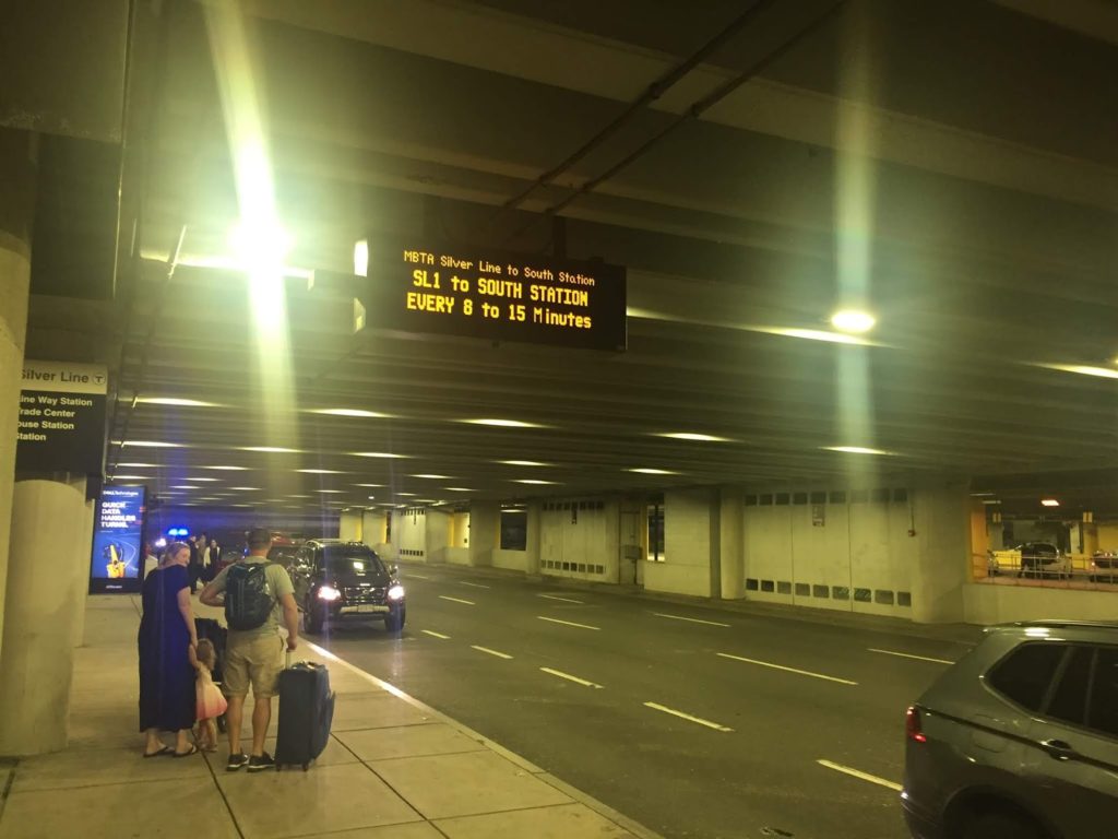
Not helpful, especially if you’re trying to figure out if the last bus has left, or even deciding if it’s worth waiting in a cab line versus waiting for the bus.

And Massport could put up static signage:

NO CABS? NO PROBLEM!
GET A CAB ACROSS THE HARBOR
MBTA BUS TO SOUTH STATION
SKIP THE LINE — SAVE MONEY
BUSES EVERY 8-15 MIN UNTIL 1:15 AM
ADDITIONAL BUS AT 2:30 AM

And as I’ve written before, with some minor schedule tweaks, the T could use the Silver Line 3 returns from Chelsea to supplement this service even later, and keep one bus in service to make an extra round trip to provide service until 2:30 when, on most nights, the planes have all landed. Alternatively, or in addition, Massport could continue its Back Bay Logan Express bus later in the evening and into the early morning (or even 24/7), providing late night trips to the taxicab-rich parts of Boston when there are cab shortages at the airport (and perhaps even direct service to large hotels in the Back Bay).

Even more, the Logan Taxi Twitter feed often includes this kind of Tweet:

By 10:00 most evenings, someone at Logan knows how many late flights are coming in. So, conceivably, the bus driver could be held on duty to make extra trips in the cases of delays. Massport, which already helps to subsidize the fares for the Silver Line, could shoulder the rather minimal cost of the extra trips. And passengers arriving at midnight would no longer have to face an hour-long wait for a cab, when there are many more options across the harbor.

The market has never provided enough cabs at Logan when they are needed, and at certain times of day, lines of cabs are the rule, not the exception. Assuming the market will take care of this has never worked, and it is unlikely that it ever will. If Massport worked with the MBTA, however, it could pilot a project to move people downtown and create a secondary taxi queue there, where drivers would be much more willing to go for a fare, because even if the demand had dried up, they wouldn’t be out the tunnel tolls, mileage and time to show up at the airport.

Don’t double down on the mistakes of the past: Cabot Yard edition

The Red Line derailment didn’t look too bad at first. The train stayed upright, there were no major injuries, and it appeared that the train would just have to be rerailed, the track repaired, and normal service would resume. The T did an excellent job setting up what skeleton service they could to bypass the site, providing rail service to Braintree and Ashmont without resorting to trying to put ten thousand people per hour on buses which would tie up half of the bus fleet (which is otherwise occupied at rush hour). It seemed the incident had happened in a relatively good location, one of the few where there was some redundancy, as passengers could just transfer from one side of the station to the other.

On Wednesday we found out just how bad it was. With the railcar finally removed (it is rumored that the reason the crane wasn’t placed on the Columbia Road bridge as originally proposed was because DCR didn’t know the maintenance level weight limit of the bridge and dropping the bridge on the Red Line would have been even worse) we saw what it hit. The little building next to the tracks housed the signal equipment for not only Columbia Junction—often dubbed Malfunction Junction, and that’s when the signal system works!—but several miles of track in either direction. Now the 14 trains per hour normally scheduled across the line—which are barely enough to handle rush hour traffic—are reduced to four to six, for the foreseeable future. It turns out that this derailment didn’t happen in a good location, but a bad one.

Signal systems are complex and bespoke, so a full replacement may take months or years to procure, if not longer. In 1996, when the Muddy River flooded into the Green Line, normal operations didn’t resume for months, and fixes for the system itself took years, and $40 million in repairs. The T now closes the Fenway portal during heavy rain events every few years to prevent a repeat of that situation. However, the proximate cause—flooding from the Muddy River—was a bigger issue: a century ago, the river was relocated in to culverts below Park Drive, and with only so much space in the culverts, it would back up along the Riverway during heavy rains, overtop the levee, and, once the D Line was built in 1959, pour in to Kenmore (which had happened in 1962 as well). This was eventually fixed as part of a 20-year project spearheaded by the Army Corps of Engineers and multiple other agencies, and with the new drainage in place, future flooding of the MBTA is less likely. Instead of continuing with the same reactionary system—where floodgates and sandbags were required every few years, and if they didn’t work, as occurred in 1996, the results would be catastrophic—we changed the larger ecosystem to one which would prevent the problem in the first place.

The Red Line derailment should serve as a similar wake-up call. Despite Governor Baker’s repeated calls for no new revenue, simply fixing the system we have won’t work. We—and I’m putting this in italics—can not continue to double down on the same system we have and expect different results. In the short term, this is going to require we invest in the system to make it more efficient and more resilient. In the long term, addressing wider problems will create the sort of system that will pay dividends when things like this week’s derailment occur less frequently and, when they occur, have less impact.

A short history of Cabot Yard and Columbia (a.k.a. Malfunction) Junction

The Red Line was the last of Boston’s subways to be built. The original segment operated between Harvard and Park and it was eventually extended, as the “Cambridge-Dorchester tunnel“, to Ashmont. At first, the only yard facility was on the north end of the line at the Eliot Shops, a complex of yards and shops tucked between Harvard Square and the Charles River, which is home to the Kennedy School today. When the line was extended in the 1920s, it added another yard—Codman Yard—past Ashmont station. For the next 50 years, the line would operate quite simply: trains would pull out of a yard beyond the terminal, service the line, and then pull into the yard at the terminal. This is optimal: the line requires no mid-line switches, and every train coming in or out of service simply pulls in to the first stop.

The 1970s and 1980s changed that. In 1965, the T purchased the Old Colony right-of-way to build an extension to Quincy and Braintree. This was originally planned to be an independent, express line (which is why there is no Braintree station at Savin Hill or Neponset) which would terminate at South Station. Eventually, it was aligned to be part of the Red Line, which required a new junction where the lines split at Columbia Road.

More importantly, it needed somewhere to store and service the cars. The Eliot Shops were small, cramped, and sat on valuable land eyed by Harvard for years. The T gave the land to Harvard in 1966 but needed to find a new location for its yards. The Ashmont Branch was out: Codman Yard was surrounded by housing. Braintree didn’t want a rail yard at the end of the line and blocked efforts for a yard there, so the T finally paid the Penn Central for the freight yards in South Boston to store Red Line cars. This was by no means their first choice: in order to access the line, trains would have to traverse nearly two miles of non-revenue track to get to JFK-UMass, and would then have to run the rest of the way back to Braintree to begin their inbound trips. (A small yard—called Caddigan, in keeping with an apparent rule that all Red Line facilities must begin with a hard C—exists past Braintree, but it can only store a few cars.)

This issue was exacerbated in the 1980s when the Red Line was lengthened once again. The line was extended from Harvard to Alewife, but was originally slated to go beyond. As late as 1977, the line was planned to Arlington Center (with an eventual extension) and the decision was made to curve the line past the Alewife station to aim towards Arlington, forgoing the ability to build a yard on then-vacant land just west of Alewife. The next year, the town decided it didn’t want rail service, but the deed was done, and no terminal was available at the north end of the line, either. (This was related to me by Fred Salvucci, who had some choice words for Arlington and Cambridge about this. I’ve written about an idea to build a yard below Thorndike Field beyond Route 2 to mitigate the terminal issues at Alewife.)

So Cabot is it. It serves most of the trips for the Red Line and is the only maintenance facility. It sits less than a mile from Downtown and the Seaport on what is undoubtedly valuable land. (The nearby MacAllen Building and its neighbor have 279 condos; the two northernmost portions of Cabot are about three times as big.) And Cabot is the main reason that the location where the train derailed—Malfunction Junction—is as complex as it is. In fact, the switch where the train derailed has nothing to do with splitting apart the branches of the Red Line, but rather a switch for a “yard lead” allowing trains to return to Cabot. The entire complex is conceptually designed quite well: it creates a series of “flying junctions”—not just between the two branches, but also for trains between the Braintree line and Cabot (most Ashmont trains operate out of Codman so therefore don’t require as frequent movement). This requires a series of complex switches and flyovers, but means that operationally no train ever has to cross another line.

Columbia Junction. North (towards Downtown Boston) is at the left. A snippet of a full MBTA track map (the best MBTA track map!) which can be found here.

But Columbia Junction, as built, is a known problem spot and frequent cause of delays, and this doesn’t change the fact that Cabot is in the wrong geographic location for a rail yard. In Chicago, nearly every yard is at the end of the line, or close by (the last mid-route yard—Wilson—was decommissioned in the ’90s in favor of a yard at Howard). New York, DC and San Francisco rely on yards mostly built on the outlying portions of the line. The T specializes in mid-route yards for the Orange and Blue lines (Wellington and Orient Heights), but both are located adjacent to the line, not miles away.

Thus, Cabot Yard has four major problems:

  • It connects to the wrong part of the line for a rail yard
  • It is not even close to said line
  • Where it connects to the line it requires a series of complex switches
  • It sits on otherwise valuable land, probably the most valuable land of any heavy rail yard (setting aside Commuter Rail yards downtown which, while in sensible locations operations-wise, sit on huge parcels of valuable land and which could be freed up with a North-South Rail Link, but that’s the topic of another post entirely).
The T’s plan? Rebuild Cabot Yard and Columbia Junction. The cost? At least $200 million for Cabot, and another $50 million or more for Malfunction Junction. The benefits? Negligible. Fixing the switches will help, but Cabot would still requires long non-revenue movements to get trains to the wrong part of the line to provide service and uses high-value land to store rail cars. It’s cheaper in the short run than building a new facility, but doubles down on the same issues which require extraneous operations and needless complexity. Yet this is the Charle Baker “no new revenue” vision: keep investment minimal now, continue with the same system we have even when it clearly doesn’t work, and somehow expect a different result. 
The solution, of course, would be to build a new yard facility somewhere further south along the Braintree branch of the Red Line. The question is: where?
The Braintree Split

I wrote last year about how the optimal location for bus garages is probably on state-owned land adjacent to highways, rather than next to transit stations as the T is proposing at Wellington and Riverside. No one wants a bus yard in their backyard, and building bus lots next to train stations instead of transit-oriented development is doubly wrongheaded. While rail yards are more location-constrained than bus yards (since they have to physically connect to the railroad) there is some potential to leverage the same sort of arrangement of land in Braintree for the Red Line.

If the Braintree branch were being built today, a logical location for a yard would be at what is currently the Marketplace at Braintree development. When the line was built, this was an active rail yard (a small portion still is a freight yard), and the Red Line was built on the “wrong side” of the tracks to access this parcel. Using it today would require not only nearly $100 million to buy the land and businesses, but nearly-impossible negotiations to somehow reimburse Braintree for that commercial tax base. The site south of the Braintree garage has less value (about $25 million) but is also on the “wrong side” (the Red Line is east of the Commuter Rail to allow access to what is now the Greenbush Line) and would require some sort of flyover or duck-under to gain access, while being slightly smaller than Cabot. Further south, there are some potential sites, but these would require longer lead tracks and have potential wetland impacts and NIMBY implications.

A map showing the locations of the sites mentioned above.

There is a site near Braintree, however, which would have no acquisition cost, since the state already owns it. It would have no impact on the tax base, since it has no assessed value. It will never be suitable for residential or commercial development, since it sits inside a highway interchange. It is, of course, the land within the Braintree Split. The land in the “infield” of the Braintree Split amounts to about 70 acres, which is nearly four times the size of Cabot Yard. The interchange is a “Directional-T” interchange, and designed so that at its center, three roads cross each other at the same point. The are, from lowest to highest, the mainline route from 93 north to 93 north, from Route 3 north to 93 south, and from 93 south to Route 3 south. This is important, because it would impact how a potential rail yard could be linked together.

None of the parcels bounded by the Braintree Split is as large as the entirety of the Cabot Yard (about 18 acres), although Cabot itself is split roughly evenly by the 4th Street bridge between the maintenance facility and the storage yard. Four of the sectors are roughly the same size, two are significantly smaller. Given the topographical constraints, it would be easiest to link together the 16 and 12 acre parcels. The map below shows the parcels within the Split, the size of each in acres, and, superimposed with dashed lines on the 16- and 12-acre parcels, the outlines of the Cabot shops facility and storage yard, respectively, with dashed lines.

Braintree Split parcels, with the Cabot shops and yard superimposed on the 16- and 12-acre parcels.

The Braintree Split is not as optimally located as, say, the site south of the Braintree station. It’s a bit further from the Red Line, and not at the end of the line, so some deadhead movement would be required to reach the terminal. But it’s considerably closer to both the end of the line in Braintree and to the line itself. The closest portion of the 12-acre parcel is only about 0.25 miles from the Red Line tracks, although there are some roadway ramps in between. (There are plenty of examples of rail yards interacting with highways, like the WMATA West Falls Church yard in Virginia, 98th, Rosemont and Des Plaines yards in Chicago,  and South Yard in Atlanta.

It is worth noting that Braintree Split isn’t exactly flat. If you drive from 93 south to Route 3 south, you descend from an elevation of 180 feet down to 40 feet. Rail yards have to be flat (so, you know, unmanned trains don’t roll away if their brakes fail), and rail grades, even for a rapid transit line, should be at most two or three percent. Given that the 12-acre parcel is lower than the 16-acre parcel, the two would have to be used for separate facilities, but there is no reason that the 12-acre parcel couldn’t host a storage yard with shop facilities at the 16-acre parcel. In fact, the 12-acre site is better suited for a storage facility (since it is long and narrow) while the 16-acre site would have plenty of room for a maintenance facility and potentially additional storage tracks, which might be necessary if the Red Line were one day improved to offer service every three minutes.

This would require about 1400 feet of lead tracks from the Red Line to the storage yard, and no new land acquisition as all would be built on land already owned by the state. The yard lead would extend flat over the first set of ramps and Route 3 north (the Red Line climbs at about a 3% grade out of Quincy Adams to cross over the Old Colony Commuter Rail), and would then descend down to the level of Route 3 to pass over the northbound Burgin Parkway ramp and under the southbound one. There it would split in to two, with one set of tracks leading to a level storage facility and the other extending up to the maintenance facility further north. Access to the maintenance yard would be available from near the zipper lane facility just north of the split, although parking might be better provided on the side of the highway with a pedestrian bridge for workers to access the yard. If funds were available from nearby developers, these walkways could even allow a station to provide better access to nearby office buildings to provide a shuttle service from Quincy Adams or Braintree.

Simplifying Columbia Junction and Savin Hill


There are other knock-on effects to simplifying Columbia Junction and relocating Cabot Yard.

In addition to the Old Colony Commuter Rail line running through a single-track bottleneck south of JFK-UMass (which is part of the reason only a few extra trains can be run at rush hour), there is a bottleneck on I-93 there as well. In 2012, CTPS developed a concept to add HOV lanes to I-93 and a track to the Old Colony lines (thereby removing a single-track bottleneck) near Savin Hill by burying both the Old Colony and the Red Line for the better part of a mile. Yet this concept would likely rival the Allston I-90 project in complexity and cost.

With South Coast rail now being (wrongly, in my opinion) pushed down the Old Colony Line, the FMCB has considered a similar plan. Yet this is based on the false premise that four tracks need to be provided to JFK/UMass, which is mostly required to allow access in and out of Cabot Yard from the Braintree Branch. Without the need to access Cabot Yard via a flying junction, there is no need for four tracks through Savin Hill: by combining the two Red Line branches south of Savin Hill, one of the existing Red Line tracks could be used for Commuter Rail through the Savin Hill bottleneck with only some minor modifications, at least relative to the state’s incoherent plan. In addition, by replacing Cabot Yard with a facility in Braintree, the entirety of “Malfunction Junction” could be replaced by two switches, one to split the southbound main line in to two branches, and another to combine the two northbound tracks together.

The sketches below show the current configuration of the railroads adjacent to Savin Hill, and a proposed concept. The proposed concept would have outbound trains stop at Savin Hill, but inbound trains on the Braintree Branch (which has less capacity) would bypass Savin Hill and merge in past the station (as they do today), although it could certainly be realigned to allow all trains to serve Savin Hill. North of this junction, the Red Line would operate as a simple, two-track railroad through to Andrew and on to Downtown and Alewife. Inbound passengers at JFK/UMass would no longer have to play platform roulette, or stand on the overpass and wait for the next train, as all service would take place on a single platform.

Current track layout.

Proposed track layout showing the combination of the Red Line branches moved further south.

The Cabot Yard leads and Track 61


The tracks from JFK/UMass to Cabot would not have to go unused, however. I pointed out several years ago that Track 61 could reasonably be connected to Andrew Station to provide a shuttle from JFK/UMass to the BCEC and Seaport. With the Cabot yard leads freed up, such a shuttle could instead run from JFK/UMass to the BCEC, providing a connection from Dorchester and the South Shore to the Seaport without relying on the overburdened Silver Line. There should be enough room for two light rail tracks from JFK/UMass to the Seaport (with a single-track terminal at JFK, much like the Braintree branch of the Red Line is being operated after the derailment) with the other Red Line track given over to the Commuter Rail. This would provide a useful link using the otherwise-excess right-of-way.


Cabot Yard as midday layover for Commuter Rail

While Cabot Yard is poorly-located as a Red Line facility, it is in the right place for midday Commuter Rail storage. This page is on the record saying that the best way to reduce the need for midday storage is to just run more trains, but peaks will be peaks, and having somewhere near a terminal to store trains will be important until we build the North South Rail Link (in which case trains will be able to run through the tunnel to outlying yards, freeing up land near the terminals). Today, the Commuter Rail system uses yards at Southampton (near Cabot) and Readville (at the end of the Fairmount Line, so not near Cabot, or really anything) for midday train storage.

Yet to run more trains, the agency needs more storage, so it is looking at sites in Allston and Widett Circle, despite the expense of building in these locations and their desirability as development sites. (As a participant in the planning process for Allston, the supposed need for storage drives many undesirable and expensive portions of that project.) If Cabot Yard was vacated by the Red Line, it would make a fine facility for midday storage: it’s very close to South Station and, with a rail yard on one side and bus yard on the other, a less-desirable development site. The portion of the facility between the Haul Road and 4th Street is more than double the size of Readville, and could thus replace Readville entirely while providing enough additional capacity to obviate the need for new construction in Allston or at Widett Circle.

Conclusion

As usual, actions taken in one location decades in the past cascade through the entire transportation network. NIMBYs in the 1960s pushed the T to build Cabot Yard, even if it was nowhere near the Red Line itself. A changing economy means that the land it occupies, which was little more than a post-industrial wasteland in the 1970s, is now worth hundreds of millions of dollars. The Braintree Split, built in the 1950s, provides enough room for a rail yard in its median. Malfunction—er, Columbia—Junction has always been a solution looking for a problem. By thinking pretty far outside the box, we could correct many of the mistakes of the 1970s. But it involves making an investment in infrastructure beyond just fixing what we have.

The current administration, it seems, is willing to double down on the mistakes which got us in to this mess. When the Muddy River flooded in to the Green Line, we didn’t just build a storm barrier and hope that it would work. We looked upstream for the cause, and rebuilt the Muddy River to keep it from overflowing in the first place. While the reactive solution might seem cheaper today, in the long run, unless we take proactive, decisive action, we’ll pay for the mistakes again and again.

Kudos, MBTA, on a job well done.

It’s not particularly frequent that I write (or anyone else writes) a blog post praising the MBTA (although it’s probably less frequent than it should be; the agency does a lot of good work with an old system and all-too-often inadequate funding and support) but today that is exactly what I am going to do regarding the Harvard-to-Alewife shuttle.

Some background: in 2016 I wrote a blog post about how the Harvard-Alewife shuttles could be improved. I noticed it mostly because I was on a training run for Boston (two weeks before my brush with death/fame, but I digress) and ran along Alewife Brook Parkway before taking a bus back to Harvard from Alewife. That was also for the floating slab project which has been with us since, well, at least 2011, and it sounds like the infrastructure will require continued maintenance forever, or at least until the MBTA installs a signal system which allows single-track operation (a regular occurrence for maintenance in Chicago and Washington, D.C.).

My advice went unheeded at the time. When the project came up again this fall, we (TransitMatters; if you haven’t already, become a TM member or apply for our first ever staff position) went all in. We contacted the T, city officials in Somerville and Cambridge, and wrote about it in Commonwealth. The idea is mostly sound. The pushback from the T—which we heard through intermediaries—was twofold, although any problems seemed easily solved:

  • First, they argued that it would adversely affect Alewife-Davis passengers (a valid concern, although I had someone who works with the MBTA looking at how shutdowns affect ridership look at some numbers, and these passengers account for a very small number of overall ridership, as would be expected), which could be mitigated by a single shuttle from Alewife to Davis. 
  • Second, that having buses going to multiple destinations would confuse passengers. Less valid, in my opinion. Apparently a train stopping three stops short of is normal terminal isn’t confusing, but buses with different destinations is? Or as a friend put it: “people can figure out the difference between Alewife and Braintree, right?”

In any case, on Saturday, December 1, the last day of the floating slab project, I got a message from a TransitMatters member: the T was sending buses out to different termini. Some were going to Davis. Some all the way to Alewife. I had been out of Cambridge, but once home I jumped at the opportunity to Hubway (or BlueBike) over to the Harvard Station to check it out. I wanted to see for myself. I wanted the rumor to be true. Alas, when I got there, the buses were operating “normally.”

But I noticed a peculiar difference: rather than being signed for Alewife Sta one of the buses was signed for Alewife Sta via Porter and Davis. If nothing else, this was an improvement in customer information: rather than just the terminal, it showed all of the bypassed stations. By the time I arrived, ridership was relatively low: only about 100 passengers per train, which were handled by two buses, which would be called in to the busway by inspectors as trains arrived. I was somewhat disappointed: I wouldn’t get to see the new system in practice, and that it would only live on as a rumor from a busier time of day. Nor would I be able to commend the T on trying something new. Again, just a rumor on the Internet.

So I walked down the ramp towards the pit, when I noticed a stack of papers sitting on the edge of a trash can (it was above the rim, and, no, I didn’t eat it). My curiosity piqued, I picked one up and read it. What had I’d stumbled upon?

Operator Guide: Harvard – Alewife

Saturday, December 1: 12 PM to 3 PM

We are testing a new Harvard – Alewife shuttle to use buses more efficiently and to provide a better service to our customers. There are a total of 3 different shuttle routes during this time period. A station official will let you know which route to begin when you are arrive at Harvard or Alewife.

The document went on to describe the three routes in detail, the head signs to use (this described the signage I’d seen earlier) and the fact that it had been observed earlier, but not when I was there. The details are that the T rather ingeniously came up with three routes to provide customers routes without sending all of the buses to Alewife. One route ran express from Harvard to Alewife. A second ran from Harvard to Alewife making all stops. A third ran to Davis Square only. While not as efficient as what I had proposed, it was a good balance of customer service and efficiency. I was very impressed, and I hope the test went well.

The skeptic will say “so why didn’t they try this earlier?” I’ll cut the T a lot of slack here. Transit agencies are large bureaucracies, and like ocean liners, they take some time to change course. In this case, they not only had to create this document, they had to vet the route, change the buses sign codes, and communicate with the various officials involved. Could it have happened faster? Maybe. Could it have not happened at all? Most certainly: that’s the easiest thing to do.

Maintenance shutdowns happen. They’re a necessary evil, but they’re an opportunity to experiment. ( (* see below for some brief suggestions) Unfortunately, experimentation is often something anathema to organizations like the MBTA. It takes extra effort for an often overworked staff, and even if the potential payoff is high, the willingness to fail is often low. But in this case, the MBTA tried. I would hope that it was successful, and that it will be the basis for better shuttle services for future floating Slab work, and elsewhere on the system going forwards.

So o everyone involved in the planning and operations staff at the MBTA: kudos and thank you. It’s always a risk to try something new. And to listen to some guy ranting on the Internet. You did both. I hope it worked. I hope that it will work in the future, and that the T use these sorts of situations to try new things to continue to provide the best possible service to its customers.

* Some suggestions for future experiments …

  • When the D Line is shut down from Kenmore to Reservoir, run a local shuttle bus along the route, but encourage through passengers to use the C Line from Cleveland Circle and allow fares (easiest would be to collect no fares west of Reservoir).
  • When the Orange Line is shut down past Ruggles, run every bus terminating at Forest Hills through to the start of Orange Line service, reducing the number of bus-shuttle-subway transfers by allowing passengers on buses to Forest Hills a one-seat ride to the Orange Line trains.
  • When the Green Line is shut next summer from Newton Highlands to Riverside, run alternating buses to Woodland and Riverside, instead of making every Riverside passenger make the tedious loop in and out of the Woodland station.) 
  • If the Lowell Line is shut down on weekends in the future, immediately fire anyone who proposes whatever the bus route used this fall was. Instead run buses from Lowell to Anderson/Woburn and then express to Boston, and serve the rest of the line with the adjacent 134 bus, with a couple of trips added as necessary to supplement service.

The case for extending the E Line to Hyde Square

This post was conceived of and co-written by an author who wishes to remain anonymous (I know who he/she is and fully support the content in the post).

The proposed design for the new MBTA vehicles.

With the news that the MBTA Fiscal Management and Control Board is considering a massive revamp and modernization of the Green Line, including modern rolling stock, comes the necessity to consider the future of the E Branch. Additionally, the MBTA’s Focus40 plan for the next 20 years of the MBTA makes several recommendations for the E line, in particular, which we think could be implemented relatively easily and inexpensively, and would allow the T to provide better, more efficient service in the corridor.

However, the E branch, with its street-running segments in heavy traffic and simple loop terminal, poses a problem. Should the FMCB choose to modernize the system and acquire 100-foot-long cars, two-car trains of the new rolling stock will be unable to fit into the existing Heath Street Loop, one of the smallest on the system once the Lechmere Yard is decommissioned with the coming completion of the Green Line Extension project. This would limit the capacity of any trains serving the E Line, including in the Central Subway and the GLX.

In part as a result of the MBTA’s past lack of transparency about the Arborway line, the future of the E Branch is a touchy subject and a source of frustration for many. There are some in Jamaica Plain would obviously like to see the line extended back to the Arborway, but this is unlikely. This is due to the existing reliability issues on the mixed-traffic segment and the unlikelihood of gaining high-quality dedicated right-of-way on Centre Street (where the 39 bus suffers reliability issues) and which has a narrow cross-section which is, in certain points, just 40 feet wide (narrower than any existing streetcar line in the country with the exception of two blocks of the J-Church on 30th Street in San Francisco, where, it’s worth point out, it doesn’t snow), so a full-scale restoration still seems unlikely. Indeed, the E branch is the first line to be cut when the T runs short of vehicles; recently it has been relatively frequently terminated at Brigham Circle during the evening rush on some days, apparently due to a shortage of operable trolleys (or as the T’s Twitter called it: “disabled trains“). The T has been less than transparent about this, raising bad memories of the Arborway Line’s “temporarily suspended” days, which began in 1985 and lasted for decades (unlike the final 1985 shutdown, service has generally been restored in the evening).

Despite the state of the E Branch beyond Brigham Circle, and the challenges facing it in a modernized future, ideas for its improvement continue to pop up. The line is mostly constrained by a short section of street running near Brigham Circle, where the E Line shares right-of-way not only with the congested Huntington Avenue leading from Route 9 to the Longwood Medical area, but also the frequent 39 and 66 buses. Northeastern transportation professor Peter Furth and then-student Charlie Guo put together a proposal to create a dedicated transitway through this section, a corridor—and major bottleneck—identified by CTPS analysis as one where transit riders represent a high percentage of road users at peak hour. Meanwhile, the Go Boston 2030 plan suggests extending the branch, not all the way back to the Arborway, but to Hyde Square in the northern part of JP.

The Furth-Guo proposal on Huntington Ave.

Between the recent rush-hour cutbacks and the challenges that any proposed Green Line modernization would pose to Heath Loop, it is likely that if the E Branch is to survive beyond Brigham Circle, it is in need of a plan for modernization and improvement itself. Such a plan must satisfy several elements. It should:

  • Preserve reliability for the entire E service. Unreliablity west of Brigham Circle can cause cascading delays down the line, which will become more problematic as the line is extended to West Medford.
  • Be compatible with modern rolling stock
  • Adequately serve, or even improve, the needs of current riders on the E Branch and the parallel 39 bus
  • Increase overall capacity to meet the needs of the considerable development on the Huntington Avenue corridor

This post seeks to to combine the Furth-Guo proposal with additional dedicated right-of-way on South Huntington Avenue and follow the City of Boston’s proposal to extend the E to Hyde Square. Such an extension would likely involve some rearranging and consolidation of stations, not only in the section between Tremont and Riverway as in the Furth-Guo proposal, but additionally on South Huntington.

This Huntington Transitway would have several beneficial features. It would be designed to serve both trolleys and buses; since the E will likely never be restored beyond Hyde Square, there will always be a necessity for a frequent bus serving the Centre Street corridor. As such, while a center-running configuration is clearly preferable on the Tremont-Riverway section, a side-running configuration might be preferable on portions of South Huntington. This is particularly the case on South Huntington approaching the right turn on to Riverway, where the left lane, which is used by left-turning traffic and streetcars, is often congested, while the right lane flows freely. It would also allow an accessible, level-boarding station for trolleys and buses to be built integrated into the sidewalk.

While the right lane need not necessarily be an exclusive transit lane, moving the trolley cars from the left lane to the right—if geometry allows them to then swing into a center right-of-way on the leg of Huntington leading to Brigham Circle—would allow them to bypass this congestion. In the other direction, the right lane of Huntington Avenue westbound—the one which leads to the Jamaicway and Route 9—features far longer queues than the lane leading to a left turn onto South Huntington, so dedicating that left lane to transit should have minimal impact on queuing. Transit signal priority at this intersection would also allow transit vehicles to trigger favorable signals, rather than having to wait in queues.

In the Hyde Square area, finding an adequate terminal proves somewhat challenging. South Huntington is not quite wide enough for a multi-track terminal to be easily built (although it would probably be possible) and the most obvious off-street possibility, the parking lots on the Angell MSPCA property, are too far north of the main ridership generators further south in JP. One possibility would be to acquire the properties on the south side of Barbara Street, the acquisition of which would likely cost in the $2-$3 million (given their current assessment, and which could be partially recouped by allow development on part of the parcel or as air rights); these are currently single-story buildings housing small businesses, which could be offered assistance in relocation. This would allow for three tracks and two island platforms for the future 200-foot trains, which is similar to the Expo Line’s Santa Monica terminus in the Los Angeles area. Given the capacity constraints on the central subway, more-frequent service necessitating a larger terminal would likely not be necessary (and two tracks may be sufficient). This terminal would be well-located adjacent to a library and supermarket.

A sketch of a terminal at Hyde Square south of Barbara St. The track shown as dashed may not be necessary.

This extension would also allow a significant recalibration of bus service in the corridor, making the overall system more efficient. The current E Branch is the only branch of the Green Line which has peak demand in the reverse direction, with the dominant flow toward the Longwood Medical Area in the morning and away from it toward downtown in the evening. The  parallel 39 bus has an opposite profile, inbound in the morning and outbound in the evening. This leads to inefficiency: there are often full 39 buses running parallel to empty E trains in one direction and empty buses passing by full E cars in the other. There are, in fact, four overlapping markets served along the Huntington Avenue-Centre Street corridor.

  • JP Center/Forest Hills to Back Bay. While this is served by the 39 bus, most residents of this portion of JP are within an easy walk of the Orange Line, which is significantly faster.
  • JP Center/Forest Hills to Longwood. This corridor not well-served by the Orange Line, but is served by the trunk of the 39 bus.
  • Hyde Square to Longwood. This short trip is currently only served by the 39 bus, but if the E line were extended, it would provide redundant service along this corridor.
  • Hyde Square to Back Bay. Hyde Square is the furthest point on the 39 bus from the Orange Line which is not also served by the Green Line. Thus, it is often faster to take the 39 bus downtown than to walk to the Orange Line, despite the congestion encountered by the 39 on South Huntington.

The Hyde Square E Line extension would allow simplification of this route structure. The 39 bus would still be required for the JP Center to Forest Hills trip. However, the two Hyde Square trips, which currently cause most of the crowding on the 39 bus, would instead be replaced by the E Line, which has plenty of room in this “reverse-peak” (as far as ridership is concerned) direction. Thus, the 39 bus could conceivably be truncated to the Longwood Medical Area, since the E Line would provide the necessary service from Hyde Square to Downtown and Back Bay (with service from JP Center to Downtown provided by the Orange Line, or by transferring). The current markets would be preserved, and the half-mile extension of the E Line would be balanced by truncating the 39 bus by three times that distance.

Stations would also be consolidated, to provide accessibility without too-close stop spacing. A single bus/rail station would take the place of Mission Park and Fenwood Road on Huntington Ave, serving the 39, 66 and E Line. The Riverway Station would remain, with the potential to build a level-boarding island for buses and trolley cars. The Back of the Hill and Heath Street stations would be consolidated up the hill and closer to the entrance to the VA. This would provide better access to the VA, the new apartments across the street, and place the station on a less-steep hill. A final station would be just south of Bynner Street (on a straight, flat area) before the terminal at Hyde Square. VA and Bynner could be designed as center platform stations for the E Line, and buses could stop in the travel lanes adjacent to them. This would minimize the need to remove parking spaces.

South Huntington, typical profile. Note that while a curb-lane buffered bike lane would be preferable, this setup allows
additional room for parked cars if the street is narrowed due to snow accumulation without fouling the trolley right-of-way.

South Huntington station profile, with Green Line in mixed-traffic and center platforms for trolleys, side stops for buses. Given the narrow width of the Green Line vehicles (104″, or 8’8″) it would be easy for cars and bicyclists to pass stopped trolleys in a shared lane. When trolleys aren’t present, cars could pass bicyclists.
Truncating the Back Bay portion of the 39 bus would have additional benefits, since it would not necessarily have to end its route in Longwood, but could instead provide through service. One intriguing idea would be to merge the 39 and the western half of the 47 bus. The 47 is an amalgam of bus routes: the original Cambridgeport bus (one of the first streetcars converted to a bus, in the 1920s) was extended across the Cottage Farm Bridge and lengthened over time so that it now runs from Central Square to Broadway, with a running time generally in the neighborhood of an hour. Does anyone ride the entire route? Unlikely, given that the Red Line makes the same trip in under 20 minutes. So the 47 could be broken in to two more manageable sections. The northern/western portion, from Cambridge to the LMA, could be interlined with the 39, allowing a direct trip from Cambridge to Jamaica Plain, a new travel pattern to the growing Cambridge market. City of Boston data show that there are 1500 Jamaica Plain residents who work in Cambridge (7.5% of the population; only the Downtown market is larger, yet there is no direct bus from JP to Cambridge), and this would likely be a popular route, utilizing the “backhaul” portion of the 47 with lower peak demand. The eastern/southern portion of the 47, now a more manageable route, could be extended from Broadway to City Point, allowing a one-seat crosstown ride from South Boston to the LMA. 
A mock-up of an MBTA map showing the E Line to Hyde Square, the 39 Forest Hills-Central and the 47 LMA-City Point.
Between Hyde Square and Heath Street, South Huntington Avenue is wide enough to allow a streetcar, some of the original trolley poles may be salvageable and could be reused, and most importantly, there is an active power feed under the street. Constructing this extension, and the transit priority between Heath Street and Brigham Circle, would be relatively inexpensive, and serve tens of thousands of passengers daily and improve the bus network as well. The half acre of land used for the new terminal at Hyde Square would be balanced by the opportunity to develop a similarly-sized parcel at the current location of the Heath Street Loop (and which would probably allow higher-density development). 
Extending the Green Line to Hyde Square, and improving the line south of Brigham Circle, should be seriously considered by Boston and the MBTA. Such a project would likely be eligible for federal funding, as well, as part of the FTA’s core capacity program. This program provides federal funding to projects which increase the capacity of heavily-used transit infrastructure. The stipulations for eligibility are:
  • Be located in a corridor that is at or over capacity or will be in five years
  • Increase capacity by 10% 
  • “not include project elements designated to maintain a state of good repair”
The E Line to Hyde Square appears to check all of those boxes. Is the line over capacity? Have you ever been on the Green Line at rush hour? The ability to run larger 200-foot trains, which would require a new terminal on the E Line, would definitely increase capacity by 10% (in fact, there might be other portions of the Green Line which could included in a core capacity grant package). And since this would be adding new service, it wouldn’t be a state of good repair project, even if part of it was to move some of the track on Huntington and South Huntington avenues to allow more efficient service. With the added benefit of the potential for federal funding, this project becomes an even easier sell. 

Bus yards vs TOD: where is the best place to store buses?

Boston has a bus problem. Beyond narrow, congested roads and
routes which traverse several jurisdictions—in some cases half a dozen in the
span of a single mile—there are simply not
enough buses to go around
. At rush hour, some MBTA bus routes only have
service every 20 to 30 minutes, despite crush-capacity loads on the vehicles
serving them. To add significantly more service would require the MBTA to add
additional buses to the fleet, but procurement of new vehicles is not the rate-limiting
factor. The larger issue is that the MBTA’s bus storage facilities are
undersized and oversubscribed, so adding new buses would require adding
additional storage capacity to the system, a high marginal capital cost for any
increase in service.

Before doing this, the MBTA may be able to squeeze some
marginal efficiency from the system. All-door boarding would reduce dwell
times, speeding buses along the routes. Cities and towns are working with the agency to
add queue jumps, bus lanes and signal priority, steps which will allow the
current fleet to make more trips over the course of the day. Running more
overnight service would mean that some number of buses would be on the road at
all times of the day and night, reducing the need to store those buses during
those times (although they might need to be serviced during peak hours, and may
not be available for peak service). Still, all of this amounts to nibbling
around the edges. Improving bus service may result in increased patronage, and
any additional capacity wrung out of the system could easily be overrun by new
passengers. The MBTA’s bus system is, in essence, a zero-sum game: to add any
significant capacity, the system has to move resources from one route to
another: to rob Peter to pay Paul.

Furthermore, Boston’s bus garages are
antiquated. In the Twin Cities—a cold-weather city where a similarly-sized bus
fleet provides half as many trips as Boston (although about the same number of
passenger miles)—nearly every bus garage is fully-enclosed, so buses don’t sit
outside during cold snaps and blizzards as they do in Boston. Every facility
there has been built since 1980, while several of the MBTA’s bus yards date to
the 1930s; some were originally built for streetcars. Boston
desperately needs expanded bus facilities, but it also needs new bus garages:
the facilities in Lynn, Fellsway and Quincy are in poor condition, and the
Arborway yard is a temporary facility with very little enclosed area.

However, what Boston’s bus yards lack in size or youth they
make up for in location. The MBTA bus system is unique in the country in that there is no bus service through downtown: nearly every trip to the city requires a transfer from a
surface line to a rapid transit line. In the past, elaborate transfer stations
were built to facilitate these transfers, with streetcar and bus ramps above
and below street level (a few vestiges of this system are still in use, most
notably the bus tunnel at Harvard), with bus routes radiating out from these
transfer stations. When the Boston Elevated Railway, the predecessor to
the MBTA, needed to build a streetcar yard, they generally built it adjacent to
a transfer station, and thus adjacent to as many bus routes as possible. Many
of these have become today’s bus yards, and the MBTA has some of the lowest
deadhead (out of revenue service) mileage to and from the starts of its routes.

From a purely operational standpoint, this makes sense: the
buses are stored close to where they are needed. But from an economic
standpoint, it means that the T’s buses occupy prime real estate. Unlike rail
yards, which need to be located adjacent to the lines they serve, bus yards can
be located further away. While this introduces increased deadhead costs to get
the buses from the yard to the route, it frees up valuable land for different
uses. In recent decades, the T has sold off some of its bus garages, most
notably the Bartlett Yard near Dudley and the Bennett Yard near Harvard Square,
which now houses the Kennedy School. The downside is that the T currently has
no spare capacity at its current yards, and needs to rebuild or replace its
oldest facilities.

While the agency has no concrete plans, current ideas
circulate around using park-and-ride lots adjacent to rail stations for bus
storage, including at sites
adjacent to the Riverside and Wellington stations. The agency owns these
parcels, and the parking can easily be accommodated in a nearby garage. The
issue: these parcels are prime real estate for transit oriented development,
and putting bus garages next to transit stations is not the best use of the
land. Riverside
has plans in place, and Wellington’s parking lot sits across Station Landing, which has
hundreds of transit-accessible apartments.

In addition to what is, in a sense, a housing
problem for buses, the Boston area has an acute housing problem for people. The
region’s largest bus yards are adjacent to Forest Hills, Broadway and Sullivan
Square: three transit stations with easy downtown connections. These issues are
not unrelated: there are few large parcels available for housing or transit
storage (or, really, for any other use). If the region devotes land to housing,
it may not have the ability to accommodate the transit vehicles needed to serve
the housing (without devolving the region in to further gridlock). If it uses
transit-accessible land for storing buses, it gives up land which could be used
for dense, transit-accessible housing. What the transit agency needs are sites
suitable for building bus depots, on publicly-owned land, and which would not
otherwise have a high-level use for housing.

Consider a bus maintenance facility: it is really something
no one wants in their back yard. And unlike normal NIMBYism, there actually
some good reasons for this: bus yards are noisy, have light pollution, and
operate at all times of day, but are especially busy for early morning
operations. An optimal site for a bus yard would be away from residences, near
highways (so the buses can quickly get to their routes), preferably near the
outer ends of many routes, and not on land which could otherwise be used for
transit-oriented development. It would also avoid greenfield sites, and
preferably avoid sites which are very near sea level, although if necessary
buses can be stored elsewhere during predicted seawater flood events.

The MBTA is in luck. An accident of history may provide
Boston with several locations desirable for bus garages, and little else. While
most sites near highways don’t have enough space for bus yards, when the regional
highway system was canceled
in the early 1970s, several interchanges had
been partially constructed, but were no longer needed. While portions of the
neighborhoods cleared for highways have been, or could be, repurposed in to
developable land, the “infields” of highway ramps is not generally ripe for
development. Yet they’re owned by the state, currently unused, convenient to highways
and unlikely to be used for any other purpose. For many bus routes, moving to
these locations would have a minimal effect on operation costs—deadhead pull-in
and pull-out time—and the land will otherwise go unused. Land near transit
stations is valuable. Land near highways is not.

Building bus yards in these locations would allow the T to
add vehicles to the fleet while potentially closing some of its oldest,
least-efficient bus yards, replacing them with modern facilities. They wouldn’t
serve all routes, since many routes would still be optimally served by
closer-in yards with shorter deadhead movements to get the buses to the start
of the route. (To take this to an extreme: it would be very cheap to build a
bus yard at, say, the former Fort Devens site, but any savings would be gobbled
up by increased overhead getting the buses 35 miles to Boston.) Highway ramps
are optimal because it allows buses to quickly access the start and end of
routes, many of which, by history and happenstance, are near the highways
anyway.

Most importantly: moving buses to these locations would enhance
opportunities for additional housing, not preclude it. Building thousands of
new housing units adjacent to transit stations pays dividends several times
over. It increases local tax revenues and also creates new, fare-paying transit
riders without the need to build any new transit infrastructure. Finally, by
allowing more people to use transit for their commutes, it reduces the growth
of congestion, allowing people driving—and people riding transit—to move more
efficiently.

Specifically, there are five highway sites in the region
which could be repurposed for bus fleet facilities:

  • Quincy, in between the legs of the
    Braintree Split
  • Canton, on the aborted ramps of
    the Southwest Expressway
  • Weston, where the new all-electric
    tolling has allowed for streamlined land use
  • Burlington, in the land originally
    planned for the Route 3 cloverleaf
  • Revere, in the circle where the
    Northeast Expressway was originally planned to branch off of Route 1 through
    the Rumney Marshes.

In more detail, with buses counts from the MBTA’s 2014
Blue Book
. These are in-service buses required, so the total number of buses
at each location, accounting for spares, would be 15 to 20 percent higher. The
system currently maintains approximately
1000 buses
.

Quincy (67 buses)

All 200-series Quincy Routes

The current Quincy garage serves the
200-series routes, with a peak demand for 67 vehicles. The current garage is in
need of replacement. The current yard takes up 120,000 square feet on Hancock
Street, half a mile from Quincy Center station. This could easily be
accommodated within or adjacent to the Braintree Split, with minimal changes to
pull-out routes. Serving additional routes would be difficult, since the
nearest routes run out of Ashmont, and pull-out buses would encounter rush hour
traffic, creating a longer trip than from the current Cabot yard.

Canton (35
buses)

Routes
24, 32, 33, 34, 34E, 35, 36, 37, 40

This would be a smaller yard and would
probably only operate during weekdays with minimal heavy maintenance
facilities, but would reduce the overall number of buses requiring storage
elsewhere.

Weston (71 buses)

Routes 52, 57, 59, 60, 64, 70/70A, all
500-series express bus routes.

With the recent conversion to all-electronic
tolling on the Turnpike and different ramp layout, the land is newly-freed,
plentiful, and many buses serving this area have long pull-out routes from
Boston. The portion between the two branches of the Turnpike and east of the
128-to-Turnpike ramp is 500,000 square feet, the same size as the Arborway
Yard, and there’s additional room within the rest of the interchange. Without a
bus yard west of Boston, any route extending west or northwest would benefit
from this yard.

Burlington (50 buses)

Routes 62, 67, 76, 77, 78, 79, 134, 350, 351,
352, 354

These routes utilize serve the northwest
suburbs, but most are served by the Charleston and Bennett divisions in
Somerville. Most routes would have significantly shorter pull-outs.

Revere (157 buses)

The two oldest bus garages north of Boston are
Lynn and Fellsway, which account for a total of 125 buses and about 200,000
square feet. They are both centrally-located to the bus network, so moving
buses to the 128 corridor would result in longer pull-outs, except for a few
routes noted above. However, the circle where Route 1 turns northeast and the
Northeast Expressway was originally planned and graded towards Lynn across
Rumney Marshes has 750,000 square feet, and the extension towards the marshes
more. The fill is far enough above sea level to not worry about flooding, and
grade separation allows easy exit and entry on to Route 1. Some buses may make
sense to base at the Route 3 site, particularly the 130-series buses. In
addition to the Lynn and Fellsway buses, this site could take over for many
routes currently operating out of the Charlestown yard, freeing up capacity
there for other uses.

Other routes served by the Charlestown yards
would face somewhat longer pull-out times from Revere, but given the development
potential in Sullivan Square, the T could consider downsizing the yard facility
there and moving operations to a less valuable site. This site, at more than
one million square feet, could likely replace the Charlestown bus facility
entirely.

The mystery of the 600 feet between the Red and Blue lines

Last month, the MBTA presented its “Focus40” list of items it wants to complete by 2040. The Commonwealth Magazine article noted that the report states that the Blue and Red lines are only 600 feet apart, and connecting them would provide a two-minute walk in lieu of the Red-Blue connector at Charles. This sounds good. The only problem with this is that the Red and Blue lines are more than 600 feet apart. Quite a bit more. In fact, the walk from a Red Line train to a Blue Line train is more than three times as long. Where did the 600 foot figure come from? Let’s find out, with old-timey maps!

The Red Line runs beneath Winter and Summer streets. The Blue Line runs under State Street. These streets are, according to Google Maps (and, I assume, in real life), more than 1500 feet apart. But it turns out, that’s not even the real distance you’d have to walk between the subway lines. Boston’s subways were not built in a particularly coordinated fashion (although, unlike New York, which had two competing subway companies, the Boston Elevated Railway, or BERy, was the only game in town). The Green Line tunnel was built first, the Blue Line second (and, thus, below the Green Line) and the Orange Line tunnel third below the Blue (the Orange Line running through downtown predates the Blue Line, but for 7 years it ran on the Green Line’s tracks). Each newer tunnel went under the others, which is why the Green Line runs above. The Red Line wasn’t built until several years later, running below both the Green and Orange lines.

All of the lines were built within the confines of Boston’s notoriously old and narrow street grid, which was nearly three centuries in the making even then. So to fit stations in, and stairs between subway lines, both the Red and Blue Line stations are offset east of the Orange Line, and the Orange Line platforms are offset on separate sides of the subway to fit within the width of Washington Street.

Up until the 1960s, in fact, platforms were referred to as separate stations by the street they intersected, rather than station names. So the Downtown Crossing complex was referred to as Winter for the Forest Hills-bound platform, Summer for the Oak Grove-bound platform (then the Everett-bound platform) and Washington for the Red Line platforms. (It doesn’t help matters that most road names in Boston change at Washington Street.) Similarly, State was Milk-State on the Orange Line and Devonshire on the Blue Line. This seems nonsensical, until you think about it: to get to the Milk Station, you entered on Milk Street. To get to the State station, you entered on State Street. There are more examples; as this page posted long ago.

In any case, the Blue Line platform extends east from Devonshire Street, hence the name. The Red Line platform has entrances on Washington Street, but the actual platform begins around Hawley Street. To walk from Hawley to Devonshire via Washington? That turns out to be a walk of 1900 feet, up (or down) two stairs (since the Orange Line is built under the Blue Line, and the Red Line is under the Orange Line).

So where does this 600 foot figure come from? I’m actually not quite sure. What I think the number is indicating is the distance which would have to be dug between the two Orange Line platforms to provide a pedestrian connection between the Red and Blue lines. To make sense of this, we’re going to have to think in three dimensions (at least). Lucky for us, the Boston Transit Commission issued yearly reports during the construction of the subways in the early 1900s, and Ward Maps has them on their website (and has provided me with some high-resolution copies for this article, so shout out to Ward Maps for being excellent).

Remember that the Orange Line platforms are offset laterally. At Downtown Crossing, for instance, the northbound platform extends from Summer Street 350 feet north to Franklin Street, and the southbound platform south to Temple Place. In fact, the MBTA has been experimenting with new GTFS features to show the layout of Downtown Crossing, which you can view here. (Note, on the right side, the multiple levels; click B1 and B2 to toggle between.)

For the Milk-State platforms, this gets a bit more complicated. Washington Street is narrow enough at Winter/Summer: about 60 feet between buildings, but by the time you get to Milk Street, it’s narrower: only about 40 feet. Some of Boston’s oldest buildings stand here—the Old South Meeting House and Old State House date to the early 1700s—and the subway had to be built between the foundations; in the case of the Old State House, a subway entrance was built right in to the basement. (There are also newer buildings and, because reasons, parking garages.) This is barely wide enough for two subway tracks and a platform. So what did they do? They offset the platforms vertically: in effect, they stacked the trains.

Here’s what the tunnel looked like just south of the Milk platform when it was under construction around 1906:

Original caption: Portion of platform of Milk St Station over the track for northbound cars. 
For orientation, the Old South Meeting House is approximately to your right (and above). Original file.

If you’re familiar with State station, this is the platform you exit off of coming on a train from Oak Grove. To get to the Blue Line, you walk along a corridor which is sort of an extension of the platform—dubbed, apparently, the speedway (from this detailed 1909 article on the tunnel), and now home to funky colors—and then the State platform, with trains to Oak Grove also to your left, and with escalators to the Blue Line to your right.

Here’s a map from 1913 showing the stations (and, yes, it’s the best map I can find of the actual locations of station concourses). I’ve shown current station names in all-caps, and former station names in lowercase; for DTX and State, I’ve outlined the platforms in their current colors and labeled the platforms with their original names. Note that while the Orange Line platforms were built 350 feet long, and only had to be lengthened minimally to accommodate six-car trains. (Original file from Ward Maps)

View the full-size version.
I think the idea to connect the Red and Blue line stations comes from the fact that the Milk platform (the southbound State platform) extends to Milk Street, and the Summer platform (the northbound Downtown Crossing platform) extends to Franklin Street, and those streets are only about 300 feet apart. I’m still not sure where the 600 comes from, but 300 is half of 600, so this should be twice as easy. Right?

Well, not quite. Look back up at the photograph above and imagine extending the Milk (Southbound State) platform shown 300 feet east (towards you) to meet the Summer (Downtown Crossing) platform. It would have to extend above the Oak Grove-bound Orange Line platform. When Oak Grove trains leave Downtown Crossing, then descend quickly to dive under the Milk Street platform pictured, descending at a 5.5% grade. So this would not be a level ramp by any means; in fact, a 5.5% grade exceeds the maximum allowed by ADA regulations, so it couldn’t even be built above the tracks with infinite space above. Which is kind of moot anyway, because it would also butt up in to the top of the tunnel pretty quickly. It would therefore have to jog south of Washington Street’s right-of-way, under the buildings there, which would add complexity to construction and yet more distance to the walk.

From 1906, here’s an elevation profile of the entirety of the Washington Street tunnel (now the Orange Line) connecting the elevateds north and south of the city (from 1901 to 1908, the elevated trains ran through what is now the Green Line, and the abandoned Pleasant Street Portal). I’ve added some annotation to it. The vertical orange lines show the ends of the platforms which would be used as the route for the pedestrian path. I’ve also shown the location of the Red Line (not built at this point) and the Blue Line (called then the East Boston Tunnel, or the E.B.T.). I’ve also superimposed the location of the other-direction Orange Line platforms on each drawing, and used black lines to superimpose other elements of the tunnel. I mainly want to draw attention to the fact that a passageway between the Summer and Milk platforms could not fit within the current envelope of the Orange Line, and would have to be built to the south, because to the north there are train tracks in the way, and to the south there is the minor issue of building foundations being in the way.

View the full-size version.

Again, this comes from Ward Maps, and the original file is here, and while the original has been sold (and, alas, not to me) you can get a reprint to hang on your wall (which I am considering).

So what are the takeaways from this little exercise?

  • While the Orange Line platforms and concourses would allow a connection to be made between the Red and Blue lines, it would amount to a walk of more than a third of a mile, up or down multiple staircases, and along already narrow and crowded subway platforms. That’s 8 minutes of walking, plus climbing some stairs, and that’s assuming you can walk at 3 mph down crowded platforms. At rush hour, it might take a good deal longer. It would probably be faster to just take the Green Line one stop from Park to Government Center, since the Green Line is directly above the Red and Blue lines.
  • The 300 feet which would be needed for an additional tunnel would have to go through and underneath the building foundations outside of the footprint of the street, because the Orange Line is already threaded under Washington Street, which is very narrow.
  • The entire utility of this connection could be realized by allowing an out-of-system transfer between Downtown Crossing and State, which will be possible with the new fare system currently being procured. It only adds one flight of stairs: two up from Red to street level, then one down to Blue.
  • This would do little to actually address the issue of core capacity, which is what the Red-Blue connector aims to address. Even if this was convenient for people to use, it wouldn’t result any less crowding on the Red Line, and the Orange Line and Blue Line platforms would actually become more crowded than they are today.
As the last point alludes to, the reason for building a Red-Blue connector—a real, actual Blue Line extension to Charles/MGH—is two-fold. One is to provide a good connection between the Blue Line and the Red Line. Perhaps as important, however, is to pull some of the demand out of the core stations of the subway. Rather than crowding trains and concourses at Park, Downtown Crossing, Government Center and State, riders between East Boston and Cambridge would be able to bypass the busy core of the system altogether. You get that if you actually build a Red-Blue connector tunnel. You get that only if you actually connect the two lines, not if you build a long, arduous pedestrian connection and sell it as an innovative piece of infrastructure.
And, alas, I still have no idea where the the 600 foot figure came from.

Bus shuttle upsides: Finding opportunities from irregular operations

Starting next weekend, the Lowell Line will shut down on weekends for nearly six months, to allow the installation of Positive Train Control (PTC) and expedite track work for the Green Line extension. These are worthy and necessary projects. PTC will make the Commuter Rail system safer and more reliable, and GLX will bring better transit options to tens of thousands of daily riders.

No one likes a bus shuttle, but they do give us an opportunity to try new and innovative service patterns. Yet the T has taken the Lowell Line schedule and made it all but unusable, nearly tripling the duration of a trip from Lowell to Boston, while at the same time ignoring nearby resources—the 134 bus and the Haverhill Line—which would be duplicated by the Commuter Rail replacement service. TransitMatters recently wrote about how the MBTA could optimize Orange Line shuttles in Roxbury and Jamaica Plain using parallel Commuter Rail service, and this page has written about how the MBTA could optimize the Alewife-Harvard shuttle. This is a similar idea.

The Lowell Line dates to the 1830s—one of the first railroads in the world—when the Boston and Lowell Railroad was built as a freight line to serve the factories on the Merrimac. Its proponents underestimated the potential for passenger traffic and for the most part avoided existing town centers, yet the fast travel time—a stagecoach trip took most of a day, and even in 1835 the B&L made the trip in under an hour—attracted significant passenger traffic: an early lesson in the concept of “induced demand.” Two centuries later, the trip is still reasonably fast, direct and, because it was originally built to avoid town centers, hard to approximate with buses on nearby streets.

The railroad runs 25 miles from Boston to Lowell, while a bus zigzagging to serving each station runs 35, nearly all on narrow, local roadways. No wonder the schedule from Wellington to Lowell requires an hour and forty-five minutes. This is the reason that permanent replacement Commuter Rail service with buses on the weekend which is floated from time to time is a non-starter: buses are unable to efficiently make intermediate stops in town centers over a long distance. Rail service can, and, with the implementation of Regional Rail elements (i.e. level boarding platforms, faster-accelerating electric trains), could do so more quickly and efficiently than it does today.

As proposed, the Lowell Line bus replacement schedule makes use of Wellington’s proximity to I-93, and buses begin there, rather than downtown. This is similar to the busing taking place this summer on the Worcester Line, where buses have connected to the Green Line at Riverside. Yet for the Worcester Line, the T provides express service from Framingham to Riverside (which is significantly faster than the local route) and local service to serve stops in between. For the stations in Newton, no service is provided, but nearby bus routes, and the Green Line, provide service without slowing the trip from further out.

A similar concept could be applied to the Lowell Line. There is no redundant service for the outside portion of the route: a bus trip making each stop from Lowell to Anderson/Woburn is scheduled to take 45 minutes, as long as the full rail trip from Lowell to Boston. From there, rather than wending their way through Woburn, Winchester and Medford, replacement service could run express down I-93 to Wellington, reaching the Orange Line in an hour and, with a transfer, getting a traveler North Station in 1:15, not a particularly fast trip, but better than a two-hour crawl. For trips to and from Winchester and West Medford, no additional service would be required: it’s already there in the form of the 134 bus.

The 134 runs almost the exact same route as the proposed replacement shuttle. It passes through Winchester Center, within a stone’s throw of Wedgemere, and a half mile from West Medford (which is served directly by several other bus routes), from which it continues to Wellington. The service is provided hourly, which is more frequent than the Commuter Rail shuttles, so intermediate travelers from, say, Winchester to Lowell could ride into Wellington, and connect to a bus to Lowell. To provide the same span of service would require that a few buses—two on Sunday morning and two each evening—be extended by a few stops to Winchester (this might be something small enough that it could be done in the short term, without waiting for a new schedule). Most passengers would find taking the 134 as convenient, if not more so, than the replacement shuttles.

This idea would also save the T operating costs. The current Lowell Line shuttles are scheduled to take 1:45 from Lowell to Wellington, and 1:45 back. Running directly from Anderson/Woburn to Wellington would cut this to an hour, saving nearly 90 minutes of operating time for round each trip. With 16 round trips each weekend, this would save 22 hours of operation. Extending a few 134 trips to Winchester would claw back three or four additional hours of service, but it would still result in 18 hours of operating hours saved each weekend. Given that this project is slated to run from now until December, it will affect 20 weekends of service, and if a bus costs $125 per hour to operate, this would save the MBTA $45,000 in operating costs.

Another option, rather than running buses to Anderson/Woburn and on to Wellington, would be to skip the Anderson/Woburn stop—which is a large park-and-ride, so people using it could park at other, nearby stations—and run directly from Wilmington to Reading instead and connect to Haverhill Line service. This train runs parallel to the Lowell Line only a mile to the east, and Reading would be roughly a 40 minute ride from Lowell. The Haverhill Line weekend schedule would have to be increased slightly to provide the same level of service that the Lowell Line does: currently the Haverhill Line is served by only six trains on a weekend day, with three hours between trains. With the Lowell Line shut down, Keolis should have some additional staff available for these trains, since the net operation would still be less than the Lowell Line running. This would not only better-utilize existing resources and provide a better product to the traveling public on the Lowell and Haverhill lines (although the cost savings from less busing may be canceled out by running more trains), but it would draw in new riders to the Haverhill Line with more frequent service.

This table assumes a cost of $125 per hour for bus service, $750 per hour for rail service (estimated here), and that each train would only require a single bus.

Alternative Travel Time
Lowell↔Boston
Bus Hours Train Hours Cost:
per weekend | total
Local bus to Wellington 2:00 56 0 $7000 | $140,000
Express bus to Wellington 1:15 38 0 $4750 | $95,000
Bus to Haverhill Line 1:10 26 9 $10,000 | $200,000

Assuming you’d need two buses to handle any instances with more than 50 riders, the calculation would be:

Alternative Travel Time
Lowell↔Boston
Bus Hours Train Hours Cost:
per weekend | total
Local bus to Wellington 2:00 112 0 $14,000 | $280,000
Express bus to Wellington 1:15 76 0 $95,000 | $180,000
Bus to Haverhill Line 1:10 52 9 $13,250 | $265,000

While the Reading/Haverhill Line alternatives cost more (because they require more railroad operations) passengers would pay a Commuter Rail fare from Reading, nor does it take in to account additional Haverhill ridership, which would recoup some of this expense. Another alternative would be to have Amtrak’s Downeaster trains stop at Reading for bus passengers to Lowell, although capacity may be an issue. These estimates do not take a detailed look at how buses would be deployed, although the current schedule seems to show buses laying over at Wellington and Lowell for more than an hour, hardly an efficient use of resources. The Haverhill Line alternative, in particular, would allow a bus to make a round-trip in two hours, matching the frequency of improved train service there.

The installation of PTC gives us opportunities to experiment with different replacement service. Instead of simply drawing a line on a map, the T should be creative in leveraging existing infrastructure to provide the best possible product to the traveling public, while at the same time finding ways to reduce operating costs. These often go hand-in-hand, and the Lowell bus service is an example of how, with some small changes, the T could save time for its passengers and money for itself.

A short history of the new early morning bus service

Back in the halcyon days of March, 2016, I wrote a series of blog posts about overnight transit after the T unceremoniously axed late night transit service. I had them all planned out (if not fully written) and posted the first one at 8:30 on a Thursday morning before I went to work. (My blog posts in Pacific Time for no apparent reason.) The first post was about how the T should be clearer about when and where it provides early morning transit service, rather than burying the details on paper schedules and webpages.

It was popular, apparently. Several thousand views that day alone and it’s still one of the most read posts on this page. It caused a shouting match of sorts on Universal Hub with one commenter saying the current schedules which showed the trips with five-point-font notes were adequate (I’m still not sure why) which resulted in Stuart Spina stepping in and dropping the mic:

Is it really that hard to just publish a special Sunrise timetable?  

AND CAN THE BUSES ACTUALLY BE SIGNED UP FOR THEIR ROUTES!!!???  

Frank’s voice tells you when the doors open that the bus is “Route 192 with service to Haymarket” and yet the sign says “39 HAYMARKET” “39 VIA FOREST HILLS”…

But the best part was an email I received from the T at 11:52 a.m., barely four hours after the blog post went live from a service planner there:

Greetings. The MBTA received the following customer feedback this morning, which referenced your blog post. I can’t vouch for what he says are errors in your post, but I thought you might be interested to hear it. 

Issue Reported by the customer: Customer called to say that there is a website called amateurplanner.blogspot.com that gives a list of all the early morning bus trip . The problem is the blog is not giving out correct information. mainly on the 57 to boston and rts 117 leaving haymarket and the 109 . He would like to know if mbta could create a separate schedule in the packets for the early morning bus trip , He states that everyone does not know how to read the schedules and that’s why there is little ridership. This would stop independent bloggers from giving out incorrect information. 

As for your post, I agree that the information may be difficult to find for some users, but just like all other bus schedule info, it is available on our paper and HTML schedules for the relevant routes (e.g., the 194 trips shows up on both the 89 and 93), as well as our GTFS feed. The 191-194 numbers are purely for internal purposes in our scheduling software, and not as some sort of obfuscation. They are so different from the normal routes that we decided they should have separate route numbers rather than be listed as a variant of a normal route. Most users would likely find the normal route numbers less confusing, so that’s what the public sees when they see these trips on schedules or Trip Planner. Just as these trips are listed under the normal routes that make up the early morning trips, if you plan a trip with Google Maps or Trip Planner that uses the 194, it will display it as 89/93. 

I can see how a separate page about early AM routes might be helpful to some folks, but if I were a regular 89 or 93 rider, I would still want to have the early AM options for my route on my paper schedule for those routes, since that’s what I care about—not early AM options for the other side of town. I’ll bring up this idea for a separate sunrise service page with my colleagues, and also discuss whether we can improve how these early AM trips are described.

Let’s unpack that a bit. First, in the letter written to the T, it’s unclear exactly going on. A customer called to tell the T there is a website. Wait, really? Someone read my blog and was so incensed they called the T? And then they tip their hand. Note they go to “he would like to know …” and “He states …” Wait, who states? The customer? Or the website? I am convinced to this day that the T called themselves up and sent in this comment, particularly because it was sent to me barely four hours after the blog post went up.

If so, it would be either the quickest the T has ever responded to anything, or a testament to the fact that they really should have better things to do.

My response was that my information was not wrong (although I made some clarifications) and as Stuart pointed out it is confusing when the ASA announcement is different from the bus’s head sign. And what would preclude keeping that information on the paper maps, as well as creating a special website? They’re not mutually exclusive.

I thought my post was equivocal and fair. But apparently I’d touched a nerve.

Long story short: a week later, we’d (we = TransitMatters) proposed the entire night bus plan on this blog and in Commonwealth Magazine. Since then, we’ve been through several iterations of the plan with the T in fits and starts, and we’re working on launching a 24/7 bus route pilot in addition to earlier service (and a dedicated web page for it, although I think some mapping would help) on these additional routes. It’s been two years, but hopefully this is the start of building, as I called it two years ago: robust, equitable and efficient overnight transit.

Thinking Big? Let’s Think “Realistic” First

The MBTA’s Fiscal and Management Control Board, according to their slides, wants to “think big.”

Thinking big is a laudable goal. The only problem is that big thinking requires feasibility, and it is a waste of everyone’s time and energy if the big thinking is completely outside the realm of what can reasonably occur or be built.

Case in point: combining Park Street and Downtown Crossing into one “superstation.” The first reason this won’t happen is that it doesn’t need to happen: with the concourse above the Red Line between the two stations, they are already one complex. (#Protip: it’s faster to transfer between the Red Line at Park and the Winter Street platform on the Orange Line—trains towards Forest Hills for the less anachronistic among us—by walking swiftly down the concourse rather than getting on the train at Downtown Crossing.) But there are several other reasons why this is just not possible.

Tangent track

To build a new station between Park Street and Downtown Crossing would require tangent, or straight, track. If you stand at Park, however, you can’t see Downtown Crossing, because the tracks, which are separated for the center platform at Park, curve back together for the side platforms at Downtown Crossing. This curve is likely too severe to provide level boarding, so the track would have to be realigned through this segment. So even if it were  easy to build a new complex here, the tracks would have to somehow be rebuilt without disrupting normal service. That’s not easy.

Winter Street is narrow. Really narrow.

The next, and related, point: Winter Street is very narrow: only about 35 feet between buildings. Park Street Station is located under the Common, and the Red Line station at Downtown Crossing is located under a much wider portion of Summer Street: those locations have room for platforms. Winter Street does not. Two Red Line tracks require about 24 feet of real estate: this would leave 5.5 feet for platforms on either side before accounting for any vertical circulation, utilities and the like. Any more than that and you’re digging underneath the century-old buildings which give the area its character. That’s not about to happen. And Winter Street would be the only logical location for the station; otherwise it would force long walks for transferring passengers.

Summer Street (foreground) is wide.
Winter Street (background) is narrow.
The fact that so many streets change names crossing Washington?
Well, that’s just confusing.

Note the photograph to the right. The current Downtown Crossing station is located between Jordan Marsh on the left and Filene’s on the right (for newer arrivals: the Macy’s and the Millenium building), where Summer Street is about 60 feet wide, enough for two tracks and platforms, and it’s still constrained, with entrances in the Filene’s and Jordan Marsh buildings. Note in the background how much narrower Winter Street is. This isn’t an optical illusion: it’s only half as wide. The only feasible location for such a superstation would be between the Orange and Green lines, but the street there is far too narrow.

Passenger operations

The idea behind combining Downtown Crossing and Park Street is that it would simplify signaling and allow better throughput on the line operationally. But any savings from operations would likely be eaten by increased dwell times at these stations. At most stations, the T operations are abysmal regarding dwell times; Chicago L trains, for example, rarely spend as much time in stations as MBTA trains do, as the operator will engage the door close button as soon as the doors open. At Park and Downtown Crossing, however, this is not the case. Long dwell times there occur because of the crowding: at each station, hundreds of passengers have to exit the train, often onto a platform with as many waiting to board. This is rather unique to the T, and the Red Line in particular, which, between South Station and Kendall, is at capacity in both directions. Trying to unload and then load nearly an entire train worth of passengers at one station, even with more wider doors on new cars, just doesn’t make sense.

If Park and Downtown Crossing were little-used stations, it would make no sense to have two platforms 500 feet apart, and combining them, or just closing one, would be sensible. (Unlike New York and Chicago, the Boston Elevated Railway never built stations so close that consolidation was necessary.) But they are two of the busiest stations in the MBTA system, both for boardings and for transfers. Given the geometry of the area, both above and below ground, calling this a big idea is risible. Big ideas have to, at least, be somewhere in the realm of reality. Without a 1960s-style wholesale demolition of half of Downtown Boston, this is a distraction. The FMCB has a lot to do: they should not spend time chasing unicorns.

Better Headways? Geometry gets in the way, not just signals.

In addition to a spending time on infeasible ideas like combining Park and Downtown Crossing, the FMCB and T operations claims that it would only take a minor signal upgrade (well, okay, any signal upgrade wouldn’t be minor) to allow three minute headways on the Red Line. Right now, trains come every 4 to 4.5 minutes at rush hour (8 to 9 minutes each from Braintree and Ashmont); so this would be a 50% increase. Three minute headways are certainly a good idea, but the Red Line especially has several bottlenecks which would have to be significantly upgraded before headways can progress much below their current levels. New signals would certainly help operations, but they are not the current rate limiting factor for throughput on the line.

There are four site-specific major bottlenecks on the line beyond signaling: the interlocking north of JFK-UMass (a.k.a. Malfunction Junction), the Park-Downtown Crossing complex, the Harvard curve, and the Alewife terminal. (In addition, the line’s profile, which has a bi-directional peak along its busiest portion, results in long dwell times at many stations.) Each of these is it’s own flavor of bottleneck, and it may be informative to look at them as examples of how retrofitting a century-old railroad is easier said than done. This is not to say that a new signaling system shouldn’t be installed: it absolutely should! It just won’t allow for three minute headways without several other projects as well. From south to north:

JFK-UMass

This is likely the easiest of the bottlenecks to fix: it’s simply an interlocking which needs to be replaced. While the moniker Malfunction Junction may not be entirely deserved (the Red Line manages to break down for many other reasons), it is an inefficient network of special track work which dates to the early 1970s and could certainly use an upgrade. In fact, it probably would be replaced, or significantly improved, with the installation of a new signal system.

Park/Downtown

Right now, Park and Downtown Crossing cause delays because of both signaling and passenger loads. For instance, a train exchanging passengers at Downtown Crossing causes restricted signals back to Charles, so that it is not possible for trains to load and unload passengers simultaneously at Park and Downtown Crossing. Given the passenger loads at these stations and long dwell times at busy times of day, it takes three or four minutes for a train to traverse the segment between the tunnel portal at Charles and the departure from Downtown Crossing, which is the current rate-limiting factor for the line. If you ever watch trains on the Longfellow from above (and my new office allows for that, so, yeah, I’m real productive at work), you can watch the signal system in action: trains are frequently bogged down on the bridge by signals at Park.

A new signal system with shorter blocks or, more likely, moving blocks would solve some of this problem. A good moving block system would have to allow three trains to simultaneously stop at Park, Downtown Crossing and South Station. So this would be solved, right? Well, not exactly. Dwell times are still long at all three of these stations: as they are among the most heavily-used in the system. Delivering reliable three-minute headways would help with capacity, but longer headways would lead to cascading delays if trains were overcrowded. There’s not much margin for error when trains are this close together. Given the narrow, crowded stairs and platforms at Park and Downtown crossing, the limiting factor here is probably passenger flow: it might be hard to clear everyone from the platforms in the time between dwells. And it is not cheap to try to widen platforms and egress. A new signaling system would help, but this still may be a factor in delivering three minute headways.

The Harvard Curve and dwell times

Moving north, the situation doesn’t get any easier to remedy. When the Red Line was extended past Harvard, the President and Fellows of Harvard College would not allow the T to tunnel under the Yard, so the T was forced to stay in the alignment of Mass Ave. This required the curve just south of the station, which is limited (and will always be limited) to 10 miles per hour. The curve itself is about 400 feet long, but if any portion of the train (also about 400 feet long) is in the curve, it is required to remain at this restricted speed. So the train has to operate for 800 feet at 10 mph, which takes about 55 seconds to operate this segment alone. Given that with Harvard’s crowds, it has longer dwell times due to passenger flow, traversing the 800 feet of track within the station and tunnel beyond takes more than two minutes under the best of circumstances.

Would signaling help? Maybe somewhat, but not much. Even a moving block signal system would not likely allow a train to occupy the Harvard Platform with another train still in the curve. Chicago has 25 mph curves on the Blue Line approaching Clark/Lake and operates three minute headways, but they also frequently bypass signals to pull trains within feet of each other to stage them, something the T would likely be reticent to do. It may be possible to operate these headways but with basically zero margin for error. Any delay, even small issues beyond the control of the agency, would quickly cascade, eating up any gains made from running trains more frequently. This is a question of geometry more than anything else: if trains could arrive and leave Harvard at speed, it wouldn’t be an issue. But combining the dwell time and the curve, nearly the entire headway is used up just getting through the station.

Alewife

The three issues above? They pale in comparison to Alewife. Why? Because Alewife was never designed to be a terminal station. (Thanks, Arlington.) The original plan was to extend the Red Line to 128, with a later plan to bring it to Arlington Heights. But these plans were opposed by the good people of Arlington, and the terminal wound up at Alewife. The issues is that the crossover, which allows trains to switch tracks at the end of the line, didn’t. It wound up north of Russell Field, along a short portion of tangent track between the Fitchburg Cutoff right-of-way and the Alewife station, and about 900 feet from the end of the platform. If a train uses the northbound platform, it can run in to the station at track speed (25 mph, taking 50 seconds), unload and load at the platform, and allow operators to change ends (with drop back crews, this can take 60 seconds), and then pull out 900 feet (25 mph, taking 30 seconds) and run through the crossover at 10 mph (45 seconds). That cycle takes 185 seconds, or just about three minutes, of which about a minute is spent traversing the extra distance in and out of the station. If the train is crossing over from one track to the other would foul the interlocking, causing approaching trains to back up. And since this is at the end of the line, there’s significant variability to headways coming in to the station, so trains are frequently delayed between Alewife and Davis waiting for tracks to clear.

Without going in to too much detail, the MBTA currently has a minimum target of about 4 minute headways coming out of Alewife. Without rebuilding the interlocking—and there’s nowhere to do this, because it’s the only tangent portion of track, and interlockings basically have to be built on tangent track—there’s no way to get to three minute headways. In addition, the T is in the enviable position of having strong bidirectional ridership on the Red Line. In many cities, ridership is unbalanced: Chicago, for example, runs three minute headways on their Red Line from Howard at peak, but six minutes in the opposite direction from 95th (this results in a lot of “deadheading” where operators are paid to ride back on trains to get back to where they came from). The T needs as many trains as it can run in both directions, so it has to turn everything at Alewife (never mind the fact that there’s no yard beyond; we’ll get to that). This also means that T has to run better-than-5-minute headways until 10 a.m. and 8 p.m. to accommodate both directions of ridership. While this means short wait times for customers, it incurs extra operational costs, since these trains provide more service than capacity likely requires and, for instance, we don’t need a train leaving Alewife every four minutes at 9:30, except we have to put the trains somewhere back south.

In the long run, to add service, Alewife is probably unworkable. But there is a solution, I think. The tail tracks extend out under Route 2 and to Thorndike Field in Arlington. The field itself is almost exactly the size of Codman Yard in Dorchester. Assuming there aren’t any major utilities, the field could be dug up, an underground yard could be built with a new three-track, two-platform station adjacent to the field (providing better access for the many pedestrians who walk from Arlington, with Alewife still serving as the bus transfer and park-and-ride), a run-through loop track, and a storage yard. I have a very rough sketch of this in Google Maps here.

Assuming you could appease local population and 4(f) park regulations, the main issue is that field itself is quite low in elevation—any facility would be below sea level and certainly below the water table. But if this could be mitigated, it would be perhaps the only feasible way to add a yard to the north end of the Red Line. And it is possible that a yard in Arlington, coupled with some expansion of Codman (which has room for several more tracks) could eliminate the need for the yard facility at Cabot Yard in Boston, which is a long deadhead move from JFK/UMass station. While the shops would still be needed the yard, which sits on six acres of real estate a ten minute walk on Dot Ave from Broadway and South Station, could fetch a premium on the current real estate market.

This wouldn’t be free, and would take some convincing for those same folks in Arlington, but operationally, it would certainly make the Red Line easier to run. Upgrades to signals and equipment will help, but if you don’t fix Alewife, you have no chance of running more trains.

Overall, I’m not trying to be negative here, I’m just trying to ground ideas in realism. It’s fun to think of ways to improve the transit system, but far too often it seems that both advocates and agencies go too far down the road looking in to ideas which have no chance of actually happening. We have an old system with good bones, but those bones are sometimes crooked. When we come up with new ideas for transit and mobility, we need to take a step back and make sure they’ll work before we go too much further.

Today’s glossary:

  • Deadhead: running out of service without passengers. All the cost of running a train (or, if an operator is riding an in-service train, all the costs of paying them), none of the benefits.
  • Headway: the time between train arrivals
  • Tangent track: straight track

Editor’s note: after a busy first half of the semester, I have some more time on my hands and should be posting more than once every two months!

North Station doesn’t belong on the North-South Rail Link

The North South Rail Link has been bubbling up in the news recently (only partially because of me); perhaps as Boston realizes that it won’t meet the needs of the next century by expanding on the mistakes of the past. Now comes word that a Harvard-led team examined the cost of the project and found that while it would be costly, it wouldn’t be the $15 billion Big-Dig-esque boondoggle the Romney administration feared when it sidelined the project in 2006. (Remember that when the T doesn’t want to build something, they just make up numbers.) Given the immense savings from the project and the potential to free up huge parcels of prime real estate (that’s the topic of another post entirely), the $4 to $6 billion proposal is right in the ballpark of where a realistic cost-benefit analysis would show long-term benefits, despite the initial cost.

But I’m not going to touch on that (today, at least). I am going to touch on a mistake that everyone makes when they talk about the NSRL: the inclusion of North Station. That’s right. I don’t think North Station belongs in the North-South Rail Link, because North Station is not now—nor has it ever been—in the right location. Since we’re talking about building an entirely new station 80 feet underground, there’s no rule which says that we have to have the exact same stations. South Station belongs. North doesn’t.

Let’s look at the current downtown stations in Boston. Here’s South Station and Back Bay, showing everything within a half mile:


South Station is surrounded by some highway ramps and water, but otherwise well-located in between the Financial District and the Seaport, and it also has a Red Line connection. Now, here’s North Station:

See the problem here? Note how nearly everything to the north of North Station has no real use: it’s highway ramps, river, and parking lots. No housing. No jobs. So that when people get off the train at North Station, they almost invariably walk south, towards South Station. You could move North Station half a mile south and pretty much everyone would still be within half a mile of the train station. North Station has never been in the right location, but is there as an accident of history: it was as close in as they could build a station nearly 200 years ago (well, a series of stations for several railroads) without bulldozing half the city. It’s the right place for a surface station, but if you have the chance to build underground, it’s not.

Most NSRL plans try to mitigate this with a third, Central station, somewhere near Aquarium Station, but this has the same issue as North Station: half of the catchment area is in the Harbor:

This would give you three stations doing the job of two. Each train would have to stop three times, but the two northern stops could easily be replaced by a single stop somewhere in between. I nominate City Hall plaza. It would connect to the Orange, Green and Blue lines (at Government Center and Haymarket) and, if you draw a circle around it, it wouldn’t wind up with half of the circle containing fish.

North Station would still be served by the Orange and Green lines, and it would allow the North-South Rail Link to serve the efficiently and effectively serve the greatest number of passengers. A pair of stations in Sullivan Square and near Lechmere could allow regional access to the areas north of the river, which would sit on prime real estate if the tracks were no longer needed (they’d be underground). Since stations are much more expensive to build than tunnels (you can bore a tunnel more easily than a station), it might wind up cheaper, too.

Putting it all together, here’s a map showing the areas accessible under both the two-station and three-station schemes. Shown without any shading are areas within half a mile of the stations in both plans. Red areas are areas which are within a half mile of the three-station plan but not the two station plan, blue areas are within half a mile of stations in the two-station plan but not the three-station.

This shows that if you are willing to put a station in the vicinity of Government Center, you can get the same coverage in downtown Boston with just two stations. You lose the areas shaded in red, but these are mostly water and highway ramps. Instead, you gain most of Beacon Hill and the State House. It seems like a fair trade. (Yes, you lose direct access for Commuter Rail from North Station during major events at the Garden, but a Government Center/Haymarket station would only be a six minute walk away, or a two minute ride on two subway lines.)

In Commonwealth Magazine, I said that we shouldn’t double-down on the mistakes of the past by building larger, inefficient stub-end terminals. The same goes for North Station. The station itself is in the wrong place. If we build a North-South Rail Link, there’s no need to replicate it just because it’s always been there. Downtown Boston is compact enough it only needs two stations (plus the third at Back Bay). North Station isn’t one of them.