The next 10 miles of tunnel in Boston

In the past 30 years, Boston has been a leader (at least in the US) in building tunnels. The Big Dig, which removed the eyesore Central Artery from the center of the city and doubled highway capacity to the East Boston and the airport (which likely has something to do with the making Logan Airport one of the fastest-growing in the country), was one of the largest subterranean endeavors in the country’s history. (If you really want to see tunnels, though, head to Europe or Japan. But I digress.)

In that time, however, the region has not built any new high-capacity, subterranean transit infrastructure aside from relocating the Green Line at North Station, which didn’t add any connectivity or capacity (and it was part of the Big Dig, anyway). The Silver Line is not high capacity by any stretch of the imagination (although if it were converted to light rail, it could be much higher). Even the Green Line Extension, the first new line in decades, is being built entirely at- or above-grade.

Our competitor cities, even those in the US, are not standing still. While American cities are notoriously poor at building subways with any sort of cost controls, most every other city in the country with any sort of transit system has built some amount of underground rail infrastructure. Why do I focus on going underground? Because it’s the only way to run high-capacity transportation through a dense portion of a city. Without it, we are stuck trying to push more and more people through the infrastructure we already have: our overcrowded subways and narrow streets. We can do this, to a point. But at some juncture, we need to think bigger.

Here are what other cities have been doing since the last new subway station opened in Boston (either in 1985, when Alewife opened, or 1987, when the Southwest Corridor replaced the elevated Orange Line), from west to east (approximately, and if I missed anyone, let me know):

  • Los Angeles: The entire Metro Rail system has opened, with 18.5 miles of tunnels. With in the next decade, the amount of tunnel will nearly double as the system expands dramatically.
  • San Francisco: The BART system was mostly complete by the 1980s, including the tunnels. Since then several miles of tunnel opened in South City and San Bruno with the Millbrae/SFO extension, and several more are planned as the line is built (expensively) through San Jose. Muni is building a new tunnel diagonally across San Francisco for light rail service. At some point, Caltrain, which is currently being electrified, may be extended to the Transbay Terminal.
  • Portland: While the MAX light rail system is mostly at- or above-grade, the three-mile Robertson Tunnel runs through a major ridge west of downtown.
  • Seattle originally opened its mile-long bus tunnel in 1989. It has since converted it for light rail traffic, extended the light rail south (with a mile of tunnel through Beacon Hill), north (in a deep bore tunnel) and will continue with northward expansion as part of a major infrastructure plan which involves building more than 100 miles of high-capacity light rail by 2041.
  • The middle of the country has not seen much in the way of tunneling. Denver‘s system is entirely at-grade, while Dallas has one subway station. Saint Louis has about a mile of tunnel under downtown and shorter tunnels elsewhere. Minneapolis built a mile-long tunnel under its airport. Pittsburgh built a mile-long tunnel under the Allegheny River, and Chicago built about a mile of tunnel connecting the State Subway to the Dan Ryan Branch, allowing routes to be better optimized. Buffalo‘s light rail, which runs below grade outside the city, was completed in 1986 but hasn’t been extended since.
  • While much of the DC Metro system was completed by the mid-1980s, the last bits of tunneling weren’t completed until 1999. Baltimore‘s subway was extended by a mile and a half in 1995.
  • New York hasn’t built much since 1940, but has still managed the Second Avenue Subway, the F Train under Roosevelt Island and East Side Access (the same tunnel for part of the route), the 7 Train extension and the E train to Jamaica.
  • Which leaves Atlanta and Philadelphia. In Atlanta, MARTA‘s tunnels were completed in the late 1970s and early 1980s. Philly finished connecting its regional rail system in 1982. Much like Boston, these cities haven’t made large investments in transit since (although MARTA has been extended as planned, mostly above-grade).

So, why Boston? Why now? Because there are several short stretches which could dramatically enhance the network, and the overall capacity of the network needs to be expanded. The last increase to the system’s capacity was made in the early 1900s: since then, lines have been relocated, but not expanded. This doesn’t go into the need for wider-scale regional connectivity or faster, more efficient surface transit (both are important, but cover a much broader scale). It instead focuses on how a few miles of tunnels could transform transit capacity in the city. Much like, for better or for worse, the Big Dig did. It’s a very blue-sky approach and assumes a reasonably large investment (the state does have a billion dollar surplus), but each project is technically feasible and in most cases encompass projects which have been proposed at some point in the city’s history (albeit in some cases, a long time ago).

They are presented in approximate order of length (shortest to longest) and feasibility.

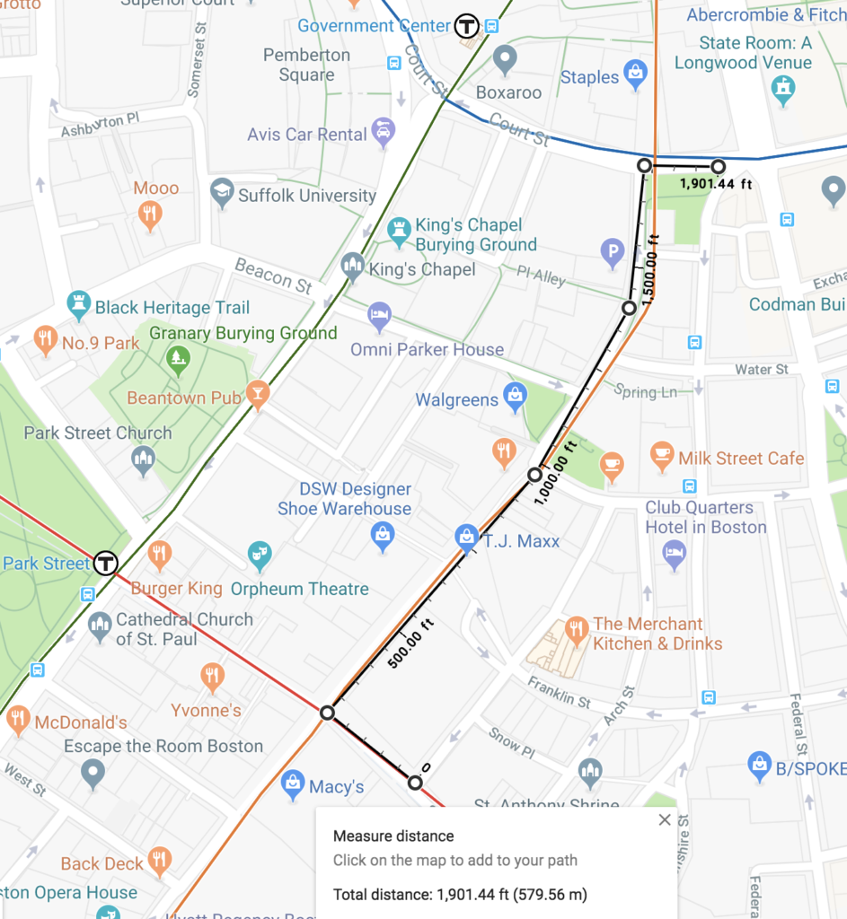
1. The Red-Blue connector (0.25 miles)


The Red-Blue connector would require about 1300 feet of new tunnel. It’s a good time for it: Cambridge Street above it is badly in need of a redesign, and MGH, next door, is planning adjacent construction. The MBTA is finally going to give it a fair shake, and it will hopefully see the light of day in the next few years.

But why is it important? Because it improves connectivity while at the same time reducing demand on the busiest part of the core of the system. It’s a win-win, for a very small investment, and should be feasible to build with minimal disruption to the rest of the system.

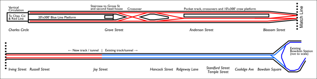
2. The Silver Line Phase III, but with rails (0.5 miles)


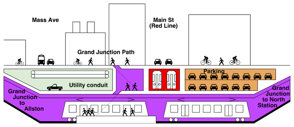
This connection has flown more under the radar screen. With the growth of the Seaport, the Silver Line buses are overburdened, and there is no good way to get to it from the Orange or Green lines without multiple transfers. The Silver Line and Central Artery were designed to include the Silver Line Phase III portion of the project, which would have run east from South Station to Boylston, and then made an asinine loop to run south to a portal somewhere near Tufts Medical Center station (they couldn’t use the old Green Line tunnel because, paradoxically, smaller buses require larger tunnels: louder now for those in the back or at Park Plaza, because buses don’t belong in tunnels). And it would have run buses, which, as we see today, have no place in tunnels with stops and have low speed and low capacity.

This idea leverages a third piece of infrastructure, and one much older: the never-used provisions for a branch of what is now the Green Line from east of Arlington to a terminal at Post Office Square. Instead of going to Post Office Square, this would extend east along the SL III plans to South Station, then through the Piers Transitway (a.k.a, the current Silver Line, which was designed to be converted to light rail, providing faster and higher-capacity service) and on to Silver Line Way, where it could be extended at-grade to the Convention Center, Seaport or elsewhere, maybe even down Track 61. No, Track 61 as a DMU shuttle just doesn’t work. This would mean a one-seat ride from Copley to the Seaport in 8 minutes, as opposed to two transfers and 20 minutes today.

I’ll defer to Vanshnookenragen for some detailed graphics about how this would work, and some other good thoughts on the Green Line.

Two tunnels down and we haven’t even dug a full mile.

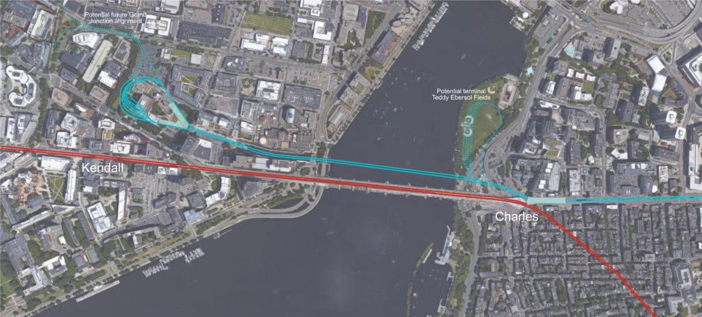
3. Grand Junction (1.25 miles)


Now we get a bit bigger.

The Grand Junction Railroad has never carried a revenue passenger in its existence, which goes back to 1846. Until recently, the right-of-way once ran through a series of industrial lots and rail yards with little potential to carry paying customers. Now? It runs from North Station and passes Cambridge Crossing, runs through the heart of Kendall Square, and then on to Allston. Kendall has some of the highest-priced real estate on the face of the earth, and is growing by leaps and bounds, despite no direct highway access, which forces car traffic onto narrow, congested streets. It’s accessible from the Red Line, and has reasonable connections to some of the rest of the transportation system, but from the north and west, transit is not time-competitive with driving, so, people drive.

Cambridge Crossing promises more demand, as does the eventual replacement of the interchange and rail yard in Allston. This provides opportunity as well: for the construction in Allston to take place, the Grand Junction will be shut down for a period of several years. In 10 years, the Grand Junction could connect Allston (millions of square feet of new development adjacent to Harvard and BU’s campuses, as well as a transfer from the main east-west rail corridor in the state) to Kendall Square to North Station, with additional stops in Cambridgeport, East Cambridge and Cambridge Crossing (where the line passes only about 600 feet from the future Lechmere Station, which would provide a transit connection from the Green Line extension to Kendall Square).

This looks a lot like where you would want a frequent, high-capacity transit line, which would increase regional transit ridership (satisfying latent demand by providing connections which do not exist today) and take existing transfers out of the core of the system. What do I mean by this? Take the example of Boston Landing station. Before that station opened, there were no good options to use transit from Allston to Downtown Boston: The 86 or 66 bus to Harvard and the Red Line, the 64 bus to Central and then the Red Line, or the 57 bus to Kenmore and then the Green Line. Since it’s opened, ridership has far exceeded expectations. Why? Because there’s now an option to go from Allston to South Station in 14 minutes instead of 40. Some of this traffic comes from people who used to cram onto the 57 or 64 buses, and others take transit instead of driving.

The Grand Junction allows a similar time savings for travel to Kendall Square, except expands the benefit to everyone coming west of Boston. A trip from Boston Landing to Kendall today involves a 35 minute ride on the 64 bus, or taking a train to South Station and then the Red Line out; without the Grand Junction, traveling between West Station and Kendall will have a similar travel time, all for a trip which will cover, as the crow flies, little more than a mile. The Grand Junction is a straight line between the Worcester Line and Kendall Square, and cuts 20 minutes from the transit commute for every current or prospective passenger going to Kendall from west of Boston. The issue is that the Grand Junction runs across four heavily-trafficked city streets in Cambridge, and providing safe passage for even moderate operating speeds or frequency would be exceedingly difficult. Unless, of course, the line were put underground.

There are two main obstacles to tunneling the Grand Junction, but one major opportunity. The first obstacle is that it can’t be a simple, shallow cut-and-cover trench, because in addition to utilities (which are present in most subway projects) the line would have to cross under the Red Line at Main Street. This would mean tunneling down below the grade of the Red Line, with the bottom of the tunnel likely reaching down 40 or 50 feet. Insurmountable? Given how many buildings in Kendall Square have recently been built with footings and basements at least that deep, no. Difficult? Yes.

The second obstacle is the land ownership. While the state has an easement across the corridor in perpetuity, it does not actually own much of it. When the Penn Central was looking to raise cash in the late 1960s and early 1970s, it sold off portions of its railroad to whoever would buy. In the case of much of the Grand Junction, the buyer was MIT. The wide corridor allows MIT to manage deliveries to its buildings and utilities under the surface, with a transportation easement on the surface for the rail line. While MIT has acquiesced to move the Grand Junction Path forward, digging a deep tunnel would be more difficult.

The opportunity, however, is that because of the Allston project, the corridor will see no rail service for a period of several years. Unlike something like the Green Line extension, where much of the cost of the project stems from rebuilding the corridor while maintaining active Commuter Rail service, the Grand Junction corridor would be a blank slate. It’s much easier to dig a hole when you don’t have to worry about what is going on above it. Roads could be shifted (shoo-flied) to allow for construction to take place (like how Harvard shifted Western Avenue in Allston for construction of an adjacent building). Work wouldn’t have to be relegated to evenings and weekends to maintain weekday train service. Given the depth of the Red Line, MIT’s utilities between Main Street and Mass Ave could be put into a newly-built conduit above the Grand Junction, allowing far easier access than the current procedure of digging around an active rail line and holes in the middle of Mass Ave. Cut-and-cover projects can be very expensive under city streets or other active alignments. But digging what amounts to little more than a mile-long basement shouldn’t be impossible.

The Main Street is more difficult, but a concept would require closing Main Street (or shifting it), uncapping the Red Line, and digging down on both sides of the tracks while maintaining service. Once the pits on both sides were at the eventual depth of the Grand Junction passing underneath, the Red Line could be shut down for a week (perhaps the very low-ridership Christmas-to-New Years week) and a prefabricated concrete box could be assembled off-site and lowered into place, with service restored on the upper portion for the Red Line and, eventually, for the Grand Junction below. MassDOT is good at installing bridges in a weekend. This is essentially the same thing: the bridge takes the Red Line over the Grand Junction.

A few more concepts:

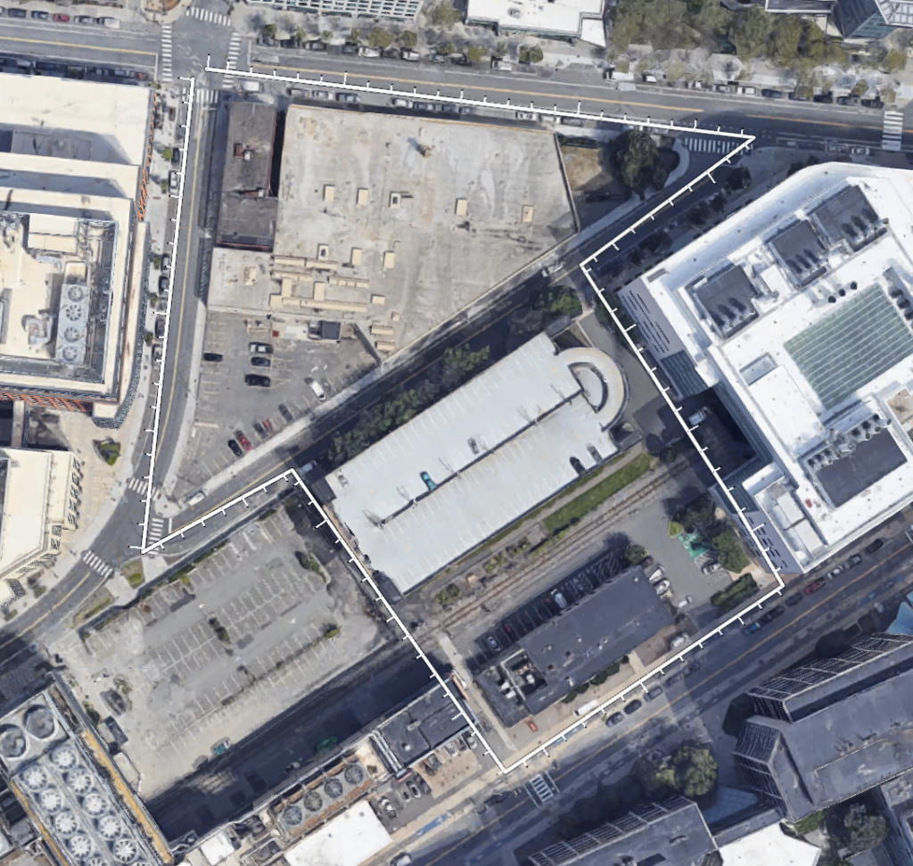
  • A Grand Junction station could be built between Main Street and Mass Ave, likely where MIT currently has a small, outdated building (Building 44) and an outdated parking garage (N4). North of this is a long-disused MIT property. Combined, these properties create an almost-perfect arrow shape, and comprise nearly 5 acres of developable land. A location atop a transit station could help the City leverage financial support for transit infrastructure in exchange for additional development rights.
  • On the north edge of the arrow property, an infill Red Line station could be built at Technology Square, filling a mile-long gap between the Red Line stations at Kendall and Central. This would provide better walking access not only to Tech Square, but also to other nearby developments, including NIBR, University Park and nearby residential districts, as well as a good transfer through the arrow property between the Grand Junction and Red Line. Given the rate of development in the corridor, a new transit station would help to relieve some of the crowding at the two existing stations.
  • Construction of a tunnel would allow a widening of the curve radius the Grand Junction currently uses between Main Street and Broadway. This would involve digging up much of the corridor there, but with the railroad already below the Red Line, it would provide the potential to add several hundred below-grade parking spaces below the street and above the rail line, which could be leveraged to allow nearby developers to build new buildings with less parking, or, perhaps, none at all. (In Delft, Netherlands, below-grade parking was integrated into a project burying a rail line.)
  • The tunnel would ascend to just below grade at Cambridge Street, and then rise east of there, tying in to the Fitchburg Line near McGrath Highway. This would probably require that Gore/Medford Street was raised several feet to accommodate the railroad grade.
  • This obviously would require electrification of at least this portion of the Grand Junction railroad, as well as the completion of additional track accessing North Station, which is planned
Here is a conceptual section (not to scale!) of a Grand Junction tunnel (looking from Kendall/MIT towards Central/Harvard):

Once the Grand Junction is rebuilt as part of the Allston project, demand for service will likely render this opportunity to shut the line down moot, so it would have to happen within the next decade. Given the opportunity to build a new transit line in an unused corridor, it should.

That’s two miles. Total.
4. Grove Hall-to-Dudley Subway (2 miles)

The first three projects look at core capacity, delivering workers to jobs, and moving people out of transfers in the center of the system. This next one doesn’t. If some cars which currently run to Park Street were instead split off to the Seaport, there would be more capacity at Park Street itself. Since the section of subway from Park Street to Boylston is four tracks, and the two extending south through the disused Pleasant Street Incline are grade separated, trains could be run in to the subway from the south, allowing service from Dudley Square to bypass the traffic and narrow streets downtown (because this is what the subway was designed for when it was built in … 1897). In other words, there’s plenty of capacity at Park Street, as long as it doesn’t all turn west at Boylston.

Why wasn’t the subway ever extended south from the Pleasant Portal? Probably because the railroad was in the way and already below grade. To extend the subway would require not just digging a tunnel, but digging it deeper: something that didn’t happen for decades anywhere in the system. By and large, other than crossing under each other, Boston’s original subways hewed close to the surface.

By 1914, what is now the Green Line subway was extended to just east of Kenmore Square, and only in 1932 did the subway cross under the railroad, first at Beacon Street and then at Huntington Avenue in 1941. (The Turnpike doesn’t make this crossing any easier.) The southern branch from Boylston was never extended under the wider New Haven and Boston and Albany right-of-way. But even the few existing, unused blocks of subway between Boylston and the portal would provide a major advantage: allowing service from the Washington Street corridor to bypass downtown traffic and extend north through the city. There is relatively little congestion south of there, and ample opportunity to run transit in a right-of-way on Washington Street: that’s where the Silver Line has lanes, even if it doesn’t need them. The Pleasant Portal could be reopened, and the line extended diagonally on the original route of the now-obliterated Pleasant Street across the land occupied by the 1970s-era Josiah Quincy School (which will likely need refurbishment or replacement at some point), and then down Washington Street.

Most of the rest of the corridor south through Roxbury to Mattapan on Washington Street and Blue Hill Avenue is wide enough that a modern light rail system could be put into place (think the Green Line, except completely different). Level boarding, prepaid fares, signal priority. The exceptions are two stretches, one through Dudley Square, and a second under Warren Street north of Grove Hall. Could surface transit run through these sections? Certainly, but it would be relatively slow, owing to narrow street widths on Warren Street and Washington Street and congestion at Dudley. North of Dudley, it would make sense to extend a tunnel past Melnea Cass, to avoid traffic-related impacts to transit. This tunnel would be more difficult to build than the Grand Junction and longer as well, and would probably require a tunnel boring machine and two stations (at Dudley and Malcolm X, which would probably be the first transit station named after Malcolm X). 
Still, this tunnel would leverage several physical assets already in place. It would allow transit from the center spine of Boston to get downtown without sitting in downtown traffic, like the Silver Line does today, and to potentially extend north along the route of the Green Line extension. It would provide the promised replacement for the Orange Line that was moved a generation ago. And it would use Blue Hill Avenue, perhaps the widest roadway of any length in the region, to transport far more people than the 28 bus can.
Four miles down. The next two are bigger bores, bigger miles, and bigger impact.
5. Seaport-Logan Regional Rail (North-South Rail Link, Part 1, 3.5 miles from South Station to Wood Island)
6. North-South Rail Link, Part 2 (2.5 miles from south of South Station to north of North Station)
The last two tunnels are the North-South Rail Link, about which my thinking about has evolved over time (for instance, with the redevelopment of North Station, I’m not so sure you’d want to skip it). Why split it in two? Because I think that the NSRL actually makes sense as two mostly-separate tunnels converging at South Station.
The first of these would of these would be a tunnel from South Station to East Boston, which was proposed as early as 1911 (!). Today, trains from Newburyport and Rockport (the Eastern Route) follow a straight line down the coast towards Boston until they get to Bell Circle, but then bend away to the north through Chelsea to loop around to North Station. The railroad originally operated towards a ferry in East Boston, but was rerouted to serve the city proper. Most iterations of the NSRL maintain this routing. 
There are two missed opportunities doing so. The first is the ability to halve the number of tracks in the main NSRL tunnel. With trains headed out on all four lines north of the city, a two-track tunnel would be unlikely to accommodate all of the service from the north (and certainly not all from the south), requiring the maintenance of surface stations and additional track on both ends of the system. Splitting off the Eastern Route would reduce demand on the main trunk enough that it could probably get by with two tracks in perpetuity. In other words, the NSRL would still have four tracks, they just wouldn’t be all together.
The second missed opportunity would be better service to Logan Airport. Transit service to Logan Airport today is pitiful and traffic at a breaking point, so despite sitting just three miles from Downtown Boston, it can take the better part of an hour to get from Logan to the city. Getting anywhere besides areas served by the Red or Blue lines requires multiple transfers, which are unattractive for all but the most budget-minded travelers, and adding time to airport staff. 
Yet imagine the following: half of the trains from the lines south of the city, including express trains from Providence and Worcester, would stop at Back Bay, South Station, a stop in the Seaport and then a central station at the airport. South Station to Logan would take 6 minutes, Back Bay to Logan 10, and Providence and Worcester would, assuming the necessary improvements to the rail network, have less-than-one-hour, door-to-door service. Some trains would terminate at an airport station (which could be built with enough tracks to allow trains to terminate and layover), and others would continue through a short tunnel under airport property and East Boston to the original route of the Eastern Railroad along Route 1A and north to Lynn, Salem and beyond, which would see faster trips both to the airport and Downtown Boston. The currently-used cutoff could provide continued service from the North Shore, or be used as a shuttle service from Revere through Everett to Sullivan Square, or even connecting to the Grand Junction. This would mimic the transit access to many large airports in Europe, like Amsterdam, Frankfurt, Zurich, Geneva, Oslo and London, where the airports are connected not only to the subway, but to larger, regional rail systems. 
Constructing such a tunnel would be difficult, but we built the Big Dig in roughly the same alignment, and constructing a parallel tunnel on the floor of the Harbor would certainly be feasible (in fact, some of the base geologic work may already be done). An airport station would be required, and expensive, but could be integrated to a major rehabilitation of the airport’s ground transportation network, which can barely cope with current traffic. This tunnel would stretch 3.5 miles—making it the longest of the tunnels proposed—yet most would be constructed under the Harbor, under open areas at the airport, or transportation corridors in East Boston. That should be easier than going straight through Downtown Boston. Although that’s a pretty low bar.
The final tunnel, about which I won’t go into further detail here, would be the classic South Station-to-North Station NSRL, only with the demand from the Eastern Route removed, and two tracks through the center of the city. All trains would connect at South Station, allowing transfers, and allowing the entire regional rail network to get to the airport with at most a single transfer. South Station is only a mile and a half from North Station and the Airport. A good transportation network would provide a simple trip to both.
Grand total: 6 tunnels, 10 miles and a bridge (so to speak) to the next century.


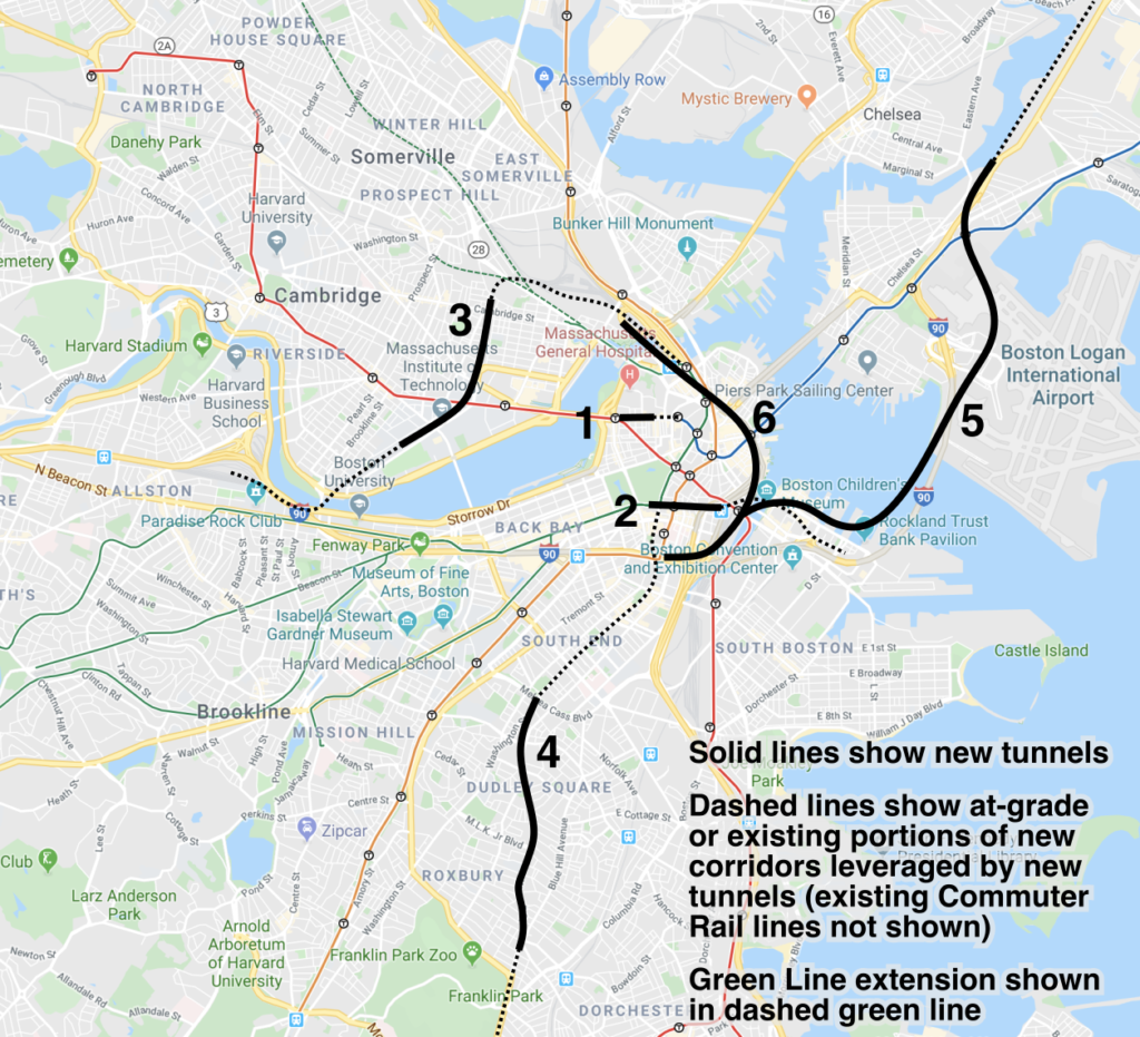
There’s plenty missing, of course. Vanshnook suggests a Green Line tunnel from Allston to Harvard and Northeastern to Brookline Village, for instance. Wentworth students have imagined a Blue Line link from Government Center to Kenmore. But for my money if I was given 10 miles of tunnel, this is how I would spend it.

The mystery of the 600 feet between the Red and Blue lines

Last month, the MBTA presented its “Focus40” list of items it wants to complete by 2040. The Commonwealth Magazine article noted that the report states that the Blue and Red lines are only 600 feet apart, and connecting them would provide a two-minute walk in lieu of the Red-Blue connector at Charles. This sounds good. The only problem with this is that the Red and Blue lines are more than 600 feet apart. Quite a bit more. In fact, the walk from a Red Line train to a Blue Line train is more than three times as long. Where did the 600 foot figure come from? Let’s find out, with old-timey maps!

The Red Line runs beneath Winter and Summer streets. The Blue Line runs under State Street. These streets are, according to Google Maps (and, I assume, in real life), more than 1500 feet apart. But it turns out, that’s not even the real distance you’d have to walk between the subway lines. Boston’s subways were not built in a particularly coordinated fashion (although, unlike New York, which had two competing subway companies, the Boston Elevated Railway, or BERy, was the only game in town). The Green Line tunnel was built first, the Blue Line second (and, thus, below the Green Line) and the Orange Line tunnel third below the Blue (the Orange Line running through downtown predates the Blue Line, but for 7 years it ran on the Green Line’s tracks). Each newer tunnel went under the others, which is why the Green Line runs above. The Red Line wasn’t built until several years later, running below both the Green and Orange lines.

All of the lines were built within the confines of Boston’s notoriously old and narrow street grid, which was nearly three centuries in the making even then. So to fit stations in, and stairs between subway lines, both the Red and Blue Line stations are offset east of the Orange Line, and the Orange Line platforms are offset on separate sides of the subway to fit within the width of Washington Street.

Up until the 1960s, in fact, platforms were referred to as separate stations by the street they intersected, rather than station names. So the Downtown Crossing complex was referred to as Winter for the Forest Hills-bound platform, Summer for the Oak Grove-bound platform (then the Everett-bound platform) and Washington for the Red Line platforms. (It doesn’t help matters that most road names in Boston change at Washington Street.) Similarly, State was Milk-State on the Orange Line and Devonshire on the Blue Line. This seems nonsensical, until you think about it: to get to the Milk Station, you entered on Milk Street. To get to the State station, you entered on State Street. There are more examples; as this page posted long ago.

In any case, the Blue Line platform extends east from Devonshire Street, hence the name. The Red Line platform has entrances on Washington Street, but the actual platform begins around Hawley Street. To walk from Hawley to Devonshire via Washington? That turns out to be a walk of 1900 feet, up (or down) two stairs (since the Orange Line is built under the Blue Line, and the Red Line is under the Orange Line).

So where does this 600 foot figure come from? I’m actually not quite sure. What I think the number is indicating is the distance which would have to be dug between the two Orange Line platforms to provide a pedestrian connection between the Red and Blue lines. To make sense of this, we’re going to have to think in three dimensions (at least). Lucky for us, the Boston Transit Commission issued yearly reports during the construction of the subways in the early 1900s, and Ward Maps has them on their website (and has provided me with some high-resolution copies for this article, so shout out to Ward Maps for being excellent).

Remember that the Orange Line platforms are offset laterally. At Downtown Crossing, for instance, the northbound platform extends from Summer Street 350 feet north to Franklin Street, and the southbound platform south to Temple Place. In fact, the MBTA has been experimenting with new GTFS features to show the layout of Downtown Crossing, which you can view here. (Note, on the right side, the multiple levels; click B1 and B2 to toggle between.)

For the Milk-State platforms, this gets a bit more complicated. Washington Street is narrow enough at Winter/Summer: about 60 feet between buildings, but by the time you get to Milk Street, it’s narrower: only about 40 feet. Some of Boston’s oldest buildings stand here—the Old South Meeting House and Old State House date to the early 1700s—and the subway had to be built between the foundations; in the case of the Old State House, a subway entrance was built right in to the basement. (There are also newer buildings and, because reasons, parking garages.) This is barely wide enough for two subway tracks and a platform. So what did they do? They offset the platforms vertically: in effect, they stacked the trains.

Here’s what the tunnel looked like just south of the Milk platform when it was under construction around 1906:

Original caption: Portion of platform of Milk St Station over the track for northbound cars. 
For orientation, the Old South Meeting House is approximately to your right (and above). Original file.

If you’re familiar with State station, this is the platform you exit off of coming on a train from Oak Grove. To get to the Blue Line, you walk along a corridor which is sort of an extension of the platform—dubbed, apparently, the speedway (from this detailed 1909 article on the tunnel), and now home to funky colors—and then the State platform, with trains to Oak Grove also to your left, and with escalators to the Blue Line to your right.

Here’s a map from 1913 showing the stations (and, yes, it’s the best map I can find of the actual locations of station concourses). I’ve shown current station names in all-caps, and former station names in lowercase; for DTX and State, I’ve outlined the platforms in their current colors and labeled the platforms with their original names. Note that while the Orange Line platforms were built 350 feet long, and only had to be lengthened minimally to accommodate six-car trains. (Original file from Ward Maps)

View the full-size version.
I think the idea to connect the Red and Blue line stations comes from the fact that the Milk platform (the southbound State platform) extends to Milk Street, and the Summer platform (the northbound Downtown Crossing platform) extends to Franklin Street, and those streets are only about 300 feet apart. I’m still not sure where the 600 comes from, but 300 is half of 600, so this should be twice as easy. Right?

Well, not quite. Look back up at the photograph above and imagine extending the Milk (Southbound State) platform shown 300 feet east (towards you) to meet the Summer (Downtown Crossing) platform. It would have to extend above the Oak Grove-bound Orange Line platform. When Oak Grove trains leave Downtown Crossing, then descend quickly to dive under the Milk Street platform pictured, descending at a 5.5% grade. So this would not be a level ramp by any means; in fact, a 5.5% grade exceeds the maximum allowed by ADA regulations, so it couldn’t even be built above the tracks with infinite space above. Which is kind of moot anyway, because it would also butt up in to the top of the tunnel pretty quickly. It would therefore have to jog south of Washington Street’s right-of-way, under the buildings there, which would add complexity to construction and yet more distance to the walk.

From 1906, here’s an elevation profile of the entirety of the Washington Street tunnel (now the Orange Line) connecting the elevateds north and south of the city (from 1901 to 1908, the elevated trains ran through what is now the Green Line, and the abandoned Pleasant Street Portal). I’ve added some annotation to it. The vertical orange lines show the ends of the platforms which would be used as the route for the pedestrian path. I’ve also shown the location of the Red Line (not built at this point) and the Blue Line (called then the East Boston Tunnel, or the E.B.T.). I’ve also superimposed the location of the other-direction Orange Line platforms on each drawing, and used black lines to superimpose other elements of the tunnel. I mainly want to draw attention to the fact that a passageway between the Summer and Milk platforms could not fit within the current envelope of the Orange Line, and would have to be built to the south, because to the north there are train tracks in the way, and to the south there is the minor issue of building foundations being in the way.

View the full-size version.

Again, this comes from Ward Maps, and the original file is here, and while the original has been sold (and, alas, not to me) you can get a reprint to hang on your wall (which I am considering).

So what are the takeaways from this little exercise?

  • While the Orange Line platforms and concourses would allow a connection to be made between the Red and Blue lines, it would amount to a walk of more than a third of a mile, up or down multiple staircases, and along already narrow and crowded subway platforms. That’s 8 minutes of walking, plus climbing some stairs, and that’s assuming you can walk at 3 mph down crowded platforms. At rush hour, it might take a good deal longer. It would probably be faster to just take the Green Line one stop from Park to Government Center, since the Green Line is directly above the Red and Blue lines.
  • The 300 feet which would be needed for an additional tunnel would have to go through and underneath the building foundations outside of the footprint of the street, because the Orange Line is already threaded under Washington Street, which is very narrow.
  • The entire utility of this connection could be realized by allowing an out-of-system transfer between Downtown Crossing and State, which will be possible with the new fare system currently being procured. It only adds one flight of stairs: two up from Red to street level, then one down to Blue.
  • This would do little to actually address the issue of core capacity, which is what the Red-Blue connector aims to address. Even if this was convenient for people to use, it wouldn’t result any less crowding on the Red Line, and the Orange Line and Blue Line platforms would actually become more crowded than they are today.
As the last point alludes to, the reason for building a Red-Blue connector—a real, actual Blue Line extension to Charles/MGH—is two-fold. One is to provide a good connection between the Blue Line and the Red Line. Perhaps as important, however, is to pull some of the demand out of the core stations of the subway. Rather than crowding trains and concourses at Park, Downtown Crossing, Government Center and State, riders between East Boston and Cambridge would be able to bypass the busy core of the system altogether. You get that if you actually build a Red-Blue connector tunnel. You get that only if you actually connect the two lines, not if you build a long, arduous pedestrian connection and sell it as an innovative piece of infrastructure.
And, alas, I still have no idea where the the 600 foot figure came from.

Extend Red-Blue to … Kendall?

At some point on the Internet, I’ve scoffed at the idea of extending the Blue Line across the Longfellow Bridge (somehow) and then run along Main Street to some superstation at Kendall (which there’s not room for) and then making a turn on the Grand Junction right-of-way (or something). I still do. You couldn’t reliably run the Blue Line and Red Line together on the Longfellow and they have separate loading gauges so would need different tracks at Kendall. To facilitate a Red-Blue Connector, it makes sense to stub-end the Blue Line at Charles Station and provide an easy answer to Kendall Square.

Or does it?

This would be a short and pointless blog post if the first paragraph was 100% true. Plus, I’ve written that blog post before. Twice.

One of the trickiest things about the Red-Blue Connector is shoehorning a good, useful terminal in to the space under Charles Circle. It’s not easy. You’d have to dig a wide tunnel, or long tail tracks, or dig out pocket tracks or tail tracks under a busy roadway and the supports for the Red Line. It would be somewhat difficult to build any sort of functional terminal: there’s just not the space. You could put something under Storrow Drive (technically Embankment Road) and Ebersol fields, which would result in a decent terminal, but you’d have to dig up and rebuild the fields, and you’d be digging adjacent to the river. It would provide for good operations; you could stack in several tracks for layover, storage and recovery, rather than using crossovers and/or the Bowdoin Loop.

So Ebersol would work for operations, but you’re still pushing more people in to the Red Line and the already-overburdened Kendall and Charles stations, and forcing every Kendall-bound Blue Line passenger to transfer (albeit an easier transfer than exists today). There’s another potential terminal. It’s bigger than Ebersol, would allow increased capacity across the Charles, the potential for further expansion and, oh, yeah, it’s already somewhere where a huge hole is going to be built in the near term.

I’m speaking of the Volpe site recently bought by MIT. Since they’re going to be digging a big hole, it would make sense to put something useful in it, not just more parking. It is an extra 3000 feet to tunnel from Charles Circle to Volpe, but it’s mostly in a shallow river and free from utility considerations (as far a I can tell). In theory, this should be relatively cheap tunneling: it could be done in a similar manner to the Ted Williams Tunnel: building tubes off-site, digging a trench, and sinking the tubes in to place, except downscaled by a significant factor: the width of two Blue Line trains is narrower than two highway lanes. The river is 12 to 15 feet deep just downstream of the Longfellow, so it would need to be excavated down about that much to accommodate current depths. The TWT required digging through muck and in to bedrock at times to accommodate a shipping lane clearance at low tide, but the Charles has no such river traffic. The disposal and mitigation of the sludge on the river bottom may be the trickiest part, although it would be beneficial to start cleaning up the muck on the bottom of the Charles River.

Then there’s the Broad Canal. This should be easy. It’s 15 feet deep, doesn’t need clearance for anything more than kayaks (although the waste heat from the power plant would have to be accounted for), and could be easily coffer-dammed, dug out, cleaned up, and filled in with several feet of water sheet above. To make up for any displaced water volume (hello, Waters of the United States), the canal above could be extended, Lechmere-style, to a water feature figuring in prominently in the new Volpe development.

What does this get you? A lot, actually. First of all, designing a subway loop terminal in Volpe’s basement would add minimal marginal cost to the development and would make it extremely transit-oriented, and add value to the project: there’d be no need to trek through the Marriott to Kendall Square to the Red Line for trips downtown. (Do you need a loop? Probably not, but if you can get MIT to dig the hole, you might as well put a good terminal down there, although if you wanted to run trains through to Binney and beyond in the future, you could build a simpler island platform with tail and storage tracks beyond.) This north/east side of Kendall is booming. In the past 10 years, several blocks have been rebuilt from gravel lots to job sites and residential developments: below is the same corner in 2011 and 2017, for instance. It would also bring transit a bit closer to the no-man’s-land in the mile between Kendall and Lechmere. With Volpe as the linchpin of several thousand more jobs and residents, expanding transit should be a priority in Kendall.

2011
2017

This plan would also give the Kendall area a direct connection to more of Downtown Boston, East Boston, the HYM Suffolk Downs site Boston is proposing for Amazon (but will be developed no matter where Amazon goes), and, most importantly, the airport (this could—maybe—provide the impetus to build a better connection to the airport from the Blue Line). It would provide more capacity across the Charles—although the north-of-Boston portion Red Line is most full from Central to Kendall—and more importantly would take some traffic out of the Kendall Station, which was never really designed for the number of people using it today.

Further down the road? The Volpe site hemmed in by Biogen to the west, but a right-of-way could be preserved over to Binney Street where a further extension could easily reach the Grand Junction. From there, much is possible. A line to Sullivan Square and Assembly via the Grand Junction. A line in the other direction linking Kendall to Allston, and then further west. Once GLX is complete, the Blue Line will be the only transit line which terminates in Downtown Boston, which is operationally inefficient. This would give it a terminal at both ends to improve operations.

I’m not sure how much this costs; I haven’t been able to find a good breakdown of the order-of-magnitude for the costs for the TWT. (I did speak to Fred Salvucci about it, and he said it was the cheapest and easiest part of the Big Dig to build, although that’s a pretty low bar.) I also can’t find information about the specific cost of the “Haymarket North Extension” tunnel costs, but that project seemed not to have broken the bank (as far as I can tell, the below-ground portion of that line did not use boring machines). Searching the Globe archives, the entire Haymarket North project cost $180 million at the time, equivalent to $750 million today. That number includes: the five miles of the line to Oak Grove, some tricky engineering building between buildings from Haymarket to the river, and the B&M holding up the state for $18 million ($95 million today) to build the line through Charlestown (This is more than half, considering 1970s inflation, of what the state would pay a couple years later to buy the entirety of the Boston and Maine lines in Massachusetts east of Fitchburg: $39.5 million, $170 million today). For this proposal, the state would only have to negotiate over a small portion of Broad Canal Way, and its owner—an REIT—would stand to benefit from better transit to the airport so might be willing to make the price right.

In any case, if Charles Station was built as a through station and not a terminal, it would reduce construction costs there (where they’re expensive) and improve operations. The station could even be built with side platforms to keep the width of the subway narrower. The Volpe terminal could be built basically for free if it was integrated in to the overall Volpe development. The question comes down to the cost of the underwater tunnel. If it’s reasonable—and it seems that it would be—this would make a lot of sense. What about transfers from further north on the Red Line? This would preserve the full functionality of the Red-Blue connector, except it would work even better. And if the North South Rail Link ever obviated the need for the Grand Junction to function as a freight corridor, the Blue Line could easily be extended west or north.

How MassDOT stacks the deck: Red-Blue edition

The Red-Blue connector is probably the biggest bang-for-your-buck piece of rail infrastructure in the Commonwealth of Massachusetts. With 1300 feet (¼ of a mile) of new subway, it would both provide a much better connection between East Boston, the airport and and the Red Line and serve as a major core capacity project. From the south, the Red Line, at rush hour, operates at peak capacity through downtown to Charles; as it drops passengers at South Station, Downtown Crossing and Park, it takes on transferring passengers and the load stays high. At Charles, however, there are many more destinations than origins, and demand drops. Right now, all Blue Line passengers destined for Kendall or beyond are forced on to the Green or Orange line and the Red Line at this high-utilization point. The Red-Blue connector would allow them to bypass this downtown congestion, reducing the strain on the near- or at-capacity central portion of the subway network. (Oh, and it would also allow a rethinking of Cambridge Street, which is incredibly dangerous for anyone not driving a car. But it has a pretty median.)

This page, in the past, has suggested that it may be cheaper to build an elevated Red-Blue connector, and also cast doubt (twice!) on the MassDOT’s cost estimates. Their claim is that it would cost $750 million to make the extension; which is a cost per mile of $3 billion. This per-mile cost is double the cost of recent tunnel projects in Seattle and San Francisco (where, as you may be aware, they have earthquakes) and even more than the Second Avenue Subway in New York. It’s a completely outlandish number.

And this is entirely by design.

The state is required to plan the Red-Blue connector, but they’re not actually required to build it. Because MassDOT is, at some levels, a morass of incompetence (see Extension, Green Line), they operate under the assumption that nothing new should ever be built, even if there are dramatic improvements to the overall transportation network. Remember, these are the same people who look at ridership growth and declare it “basically flat.” But not only do they want to do as little as possible, they actively stack the deck against their designs to come in so costly that they don’t make sense to build. This is the idea: inflate the cost so much that it would not make any sense to build. It’s deceitful. It’s duplicitous. And at MassDOT, it’s standard operating procedure.

(On the other hand, when MassDOT—or MassHighway—wants to build something, like the outlandish mutil-tunneling of rail lines in Dorchester to add highway capacity to the Southeast Expressway, they don’t bother to put forth a cost estimate. Or remember when we didn’t add a lane to 128 because it was going to cost too much? Yeah, me neither.)

Here’s how it’s done. As we discussed, there is an existing tunnel to Joy Street which was used until the 1950s to move East Boston cars to the old Bennett Street Yards in Harvard Square for heavy maintenance. The obvious solution is to use as much of this tunnel as possible—both to minimize digging in the street and to minimize disruption to current service—yet the state’s two alternatives don’t use it at all. Instead, with minimal justification, they propose a half-mile-long deep bore tunnel 50 feet below grade, tying in with the existing tunnel just west of Government Center. Using tunnel boring machines (TBM) makes sense for tunnels of any length, as the impact to the surface is significantly less. It is also, for longer tunnels, significantly cheaper than cut-and-cover methods. It’s fine to have that as one alternative—there are certainly advantages to using a TBM—but the fact that the alternative analysis only mentions TBMs makes it, well, not really an alternatives analysis at all.

The benefits of a TBM, however, only accrue for longer tunnels. The marginal cost of an extra foot of TBM tunnel is relatively low, but the initial cost is very high. A cut-and-cover tunnel here would require 1300 feet surface impact. Using a TBM would require less, but only slightly. Why? Because you still have to dig launch and recovery boxes for the TBM, and where the tunnel needs to be wider for stations or crossovers, it has to be dug out. Considering the substrate in Boston (mud and clay) a TBM would have to build concrete rings as it digs, and any stations or crossovers between the tunnels would have to be dug out separately. And while the total disruption would be somewhat less than a cut-and-cover tunnel, the disruption would be more spread out and extend much further, from Charles Circle to or beyond Government Center, rather than from Charles to Joy Street. Utilities would be affected in either scheme, and it’s possible that fewer utilities would be affected by a more-contained scheme between Charles Circle and Joy Street.

So in addition to carving up nearly as much street space, and over a longer distance, you’d also incur the cost of using a tunnel boring machine (they’re not cheap). You’d be building nearly a mile of new tunnel, while only incurring the benefit of about a quarter of that. And the costs are therefore much higher. This only makes sense if you don’t actually want to ever build anything. [Update 11/2017: I’ve heard through the grapevine that part of the reason only TBMs were analyzed is that Mayor Menino didn’t want anyone digging up the new streetscape on Charles Street, which he liked. The trees are nice for people driving cars, I guess. 10 years later, the road is a potholed mess, so dig, baby, dig.]

MassDOT’s plan would also build tail tracks under Charles Circle beyond the station. Tail tracks are important: it allows a terminal to continue to operate at full capacity even if a train is incapacitated: it can be shoved in to the tail track and out of the way until the end of service (or until service levels are decreased). However, they take up a good deal of space. This is less of an issue if there is extra space (like there is at Forest Hills, Wonderland or Oak Grove) or at Alewife, where the line was originally built to extend to Arlington (the tail tracks actually do cross the border). But in downtown Boston, the tail tracks require significant extra tunneling under Charles Circle, which is expensive and disruptive.

A different, more outside-the-box option is to create a “pocket track” before the final station. This serves the same purpose as the tail track—train storage near the end of the line—but rather than two long tails, it is in the middle of the two tracks short of the station. All this requires is that the tunnel be built wider here (the same width as the platform to the west requires) for this staging track. Additionally, by utilizing the existing layout at Bowdoin (with, perhaps, some modification for longer trains inbound, or even converting the station to outbound service only), the line would retain the utility of the loop there, which is eliminated in both of the state’s alternatives. While this does result in slower operation in and out of the station, it allows redundancy for turning trains: if there is any congestion or another issue at Bowdoin, some or all trains can be turned temporarily at Government Center to maintain service on the rest of the line. Eliminating this loop eliminates any such redundancy. A pocket track and the retention of the loop are nearly impossible with a bored tunnel but with cut-and-cover simply requires a somewhat wider dig.

By requiring long-term construction closure of the line west of Government Center, the state’s plan would also require new construction of a terminal station there. Government Center does have a crossover to its east, but it is a single crossover, which would not be able to handle the rush hour Blue Line schedule. This would require a new double crossover to be installed in what is a narrow section of tunnel. Utilizing the existing tunnel past Bowdoin would preclude this extra cost, as trains could continue to loop there during construction. There would be no disruption when the extension opened—not even a weekend shutdown to tie in new tracks. The same can’t be said for the State’s scheme.

State’s plan in red, my plan in blue.

Here’s a quick rundown on the major elements required to build the state’s version of the Red-Blue Connector:

  • A launch box for the TBM
  • Cut-and-cover tail tracks west of Charles Station
  • Main access to the Charles Station (planned 50′ below grade)
  • Charles Station, proposed as a sequentially excavated cavern but with no explanation of how that will be done in the fill-and-clay substrate in the area.
  • Emergency egress from Charles Station
  • Crossovers east of Charles Station
  • New Bowdoin Station (alternative 2 only)
  • Modification of existing Bowdoin Station and trackage to serve as ventillation (alternative 1 only)
  • Receiving shaft for Bowdoin station
  • Cut-and-cover track for connection to existing track at Government Center
  • New crossover west of Government Center to allow it to serve as a terminal station
  • Total cut-and-cover of approximately 800 feet, assuming the Charles Station can be built below grade (I’m skeptical).
And here’s a rundown of the elements required for a cut-and-cover tunnel from Joy Street to Charles Circle:
  • Main access to Charles Station (20′ below grade)
  • Charles Station cut-and-cover
  • Secondary access to Charles Station (possible because it would require only 20′ of vertical circulation, rather than 50′)
  • Cut-and-cover crossovers and pocket track
  • Cut-and-cover connection to existing tail tracks at Joy Street

Here’s my total-guess cost estimate for the cut-and-cover costs (and I think many of these are quite high):

1. Utility Relocation: 0.25 miles at $100m/mi = $25m
2. Cut-and-cover tunnel (mostly 40′ wide): 0.25 mi at $600m/mi = $150m
3. Rail systems: 0.25 mi at $100m/mi = $25m
4. Egress, NFPA130, etc: 0.25 mi at $200m/mi = $50m
5. Station, 1 at $50m = $50m
6. Street rebuilding, 0.33 mi at $75m/mi = $25m

This totals to $375 million, or half of what the state’s plan would cost. There’s no way to know much the state thinks it would cost, because they didn’t bother to analyze this alternative as part of their alternatives analysis.

Now, the state did address the difference in cost between a bored tunnel and a cut-and-cover tunnel. Well, sort of. The draft environmental impact report has the clause:

The resulting total cost (direct plus offsets) to construct a cut-and -cover tunnel shell is about 1.2 times the cost of the mined tunnel method. This differential may slightly decrease when the balance of construction scope (e.g., station components common to both Build Alternatives) is considered. Based on this relative cost differential and the associated environmental and social impacts, schemes utilizing mining methods were selected for further development and evaluation. 

Uh, this isn’t really how an alternatives analysis works. In a complex construction project, 20% is basically a margin of error. As we’ve seen in some other deep boring construction, it’s not uncommon to have an unforeseen obstruction which can dramatically increase the cost of a project. This can also be an issue with a cut-and-cover tunnel, although Cambridge Street was widened in the 1920s so the utilities there are a bit less complex than the centuries-old sewers under many Boston streets. The point of an alternatives analysis is too look at different alternatives and see which is the most appropriate. In this case, there are not enough alternatives, and very little actual analysis. I wouldn’t be surprised if a full analysis showed that 1300 feet of a cut-and-cover tunnel was a good deal less expensive than twice as much deep bore tunnel and the additional track connections involved.

And there is no information in this report about how they are going to build the Charles Blue Line Station 50 feet underground in the substrate of Boston with sequential mining. The Second Avenue Subway is being built in hard Manhattan schist which can be blasted apart while still maintaining structural integrity above. I’m not an engineer with this sort of experience, but given that there is no explanation of how it would take place, I’d have to doubt its veracity. The current idea is explained that the tunnels would be bored and then the station areas would be mined out in between the bored tunnels, using their structure to support the road above. I guess that could work. But it seems to add several steps (and thus increase the cost) by building the tunnels only to hack them apart to build space for stations and crossovers in between. When asked in 2011 if it was inflating the costs of the project, MassDOT was very defensive in claiming that they weren’t, and that Very Important People said the same thing, yet they didn’t actually explain why they chose the scheme that they did (beyond “we hired someone”) and as I outline here, it seems they put their thumb on the scale.

Even giving them the benefit of the doubt that a bored tunnel is the best option, the cost estimates seem out of hand. The cost of the 72nd Street Station cavern—which is 1300 feet long, the length of the Red-Blue connector from Charles to Joy Street—plus the track connections to 63rd Street is $431 million, significantly less than the Red-Blue connector. This, for a project taking place 100 feet below the street in New York City, which may be the most expensive construction market in the world.

To put it another way, I find it very hard to fathom that a ¼ mile cut-and-cover tunnel with a single station (for which the headhouse is already built) connecting in to an existing tunnel would cost three quarters of a billion dollars. Or $3 billion per mile. Some more comparisons? The cost of the Longfellow Bridge—twice as long, and rebuilding a century-old bridge while maintaining transit service—is one third the projected cost of Red-Blue. That can’t be right. The Big Dig cost less than $3 billion per mile, to build highway tunnels three times as wide, over and under several active railroad tunnels, with more ventilation and dozens of ramps. And the Red-Blue connector would cost as much? Please.

A layman’s staging plan for Red-Blue. Simplified, a bit.

A layman’s plan (as follows) would involve a shallow cut-and-cover tunnel, likely using slurry walls to support the excavation. (See Dig, Big). The tunnel would be 40 feet wide at the Charles Station and to the east for the crossovers and the pocket track, where it would taper to 20 feet for the connection to the existing trackage at Joy Street. The Cambridge Street roadway is at least 64′ wide between Charles Circle and Joy Street; with parking it is 80 feet wide. Assuming the construction could be completed in two phases (two 20-foot-wide excavations) with a 5 foot buffer around each, this would leave 34 feet for road for traffic during any construction, enough for two lanes of travel in each direction (or two in one direction, one in the other and an emergency vehicle access lane). Cambridge Street is currently a horror show for cyclists and not much better for pedestrians, and the project would allow a complete street to be built in its stead.

See larger-size file here

Would there be traffic headaches during construction? Sure, just as there have been with the Longfellow Bridge adjacent to the project area. Would it be apocalyptic? Much like the Longfellow, it would not. And the effects would stretch only from Charles Circle to Joy Street, rather than the state’s plan, which would have impacts extending from west of Charles Circle to Government Center, at least. In any case, either scheme will have short term traffic issues, but a long-term benefit, both with fewer vehicles and the potential to build a “complete street” with separated bicycling facilities and better pedestrian facilities. And get rid of the damn median!

There is no logical reason that the Red-Blue connector should be, per mile, the most expensive subway construction in the country. Unless it’s by design. And—yes, to point a finger at MassDOT—that’s exactly what I think has happened.

tl;dr: this is why we can’t have nice things.

Something is very wrong with MBTA project procurement

When the news broke about the escalating costs of the MBTA’s Green Line extension to Medford and Somerville, I can’t say I was surprised, but the cost numbers have now escalated in to absurdity. I’m not an expert in the bizarre project procurement, but the costs are now to the point where the project really should be reviewed and rebid, even if there is a delay. It is far beyond what similar projects cost in other cities, and the project procurement team at the T should be removed to allow someone from the outside to bid the project.

How ridiculous are the T’s numbers? Let’s take a look at them, and compare them with some other projects:

Minneapolis-Saint Paul Green Line
Distance: 11 miles
Cost: $957 million
Cost per mile: $87 million
Completion date: 2014
Engineering difficulties: rebuilding bridge over Mississippi River for light rail, rebuilding the entirety of University Ave lot line-to-lot line, junction and flyover with existing Blue Line in Minneapolis. Likely cheaper than the Green Line extension. But not 9 times cheaper.

Los Angeles Expo Line Phase II
Distance: 6.6 miles
Cost: $1.5 billion
Cost per mile: $227 million
Completion date: 2016
Engineering difficulties: Several grade separations, parallel bike/walk facility. Still four times cheaper than the GLX.

San Francisco Central Subway
Distance: 1.7 miles
Cost: $1.6 billion
Cost per mile: $941 million
Completion date: 2019
Engineering difficulties: full deep bore tunnel in a seismically active area with three underground stations. In a rather expensive city to work in. And barely more than the GLX, which is being constructed in a grade-separated right of way!

Seattle University Link
Distance: 3.1 miles
Cost: $1.9 billion
Cost per mile: $613 million
Completion date: 2016
Engineering difficulties: full deep bore tunnel below the water table in a seismically active area with two underground stations. And quite a bit cheaper per mile than GLX.

Now, here are two MBTA projects:

Red-Blue Connector
Distance: 1300 feet
Cost: $750 million
Cost per mile: $3 billion
Completion date: ???
Engineering difficulties: Cut and cover tunneling below the water table in a constrained corridor. Certainly no greater than building the Central Subway in San Francisco, yet somehow three times more expensive. This should probably be in the lower end of the $100 to $200 million range, not three quarters of a billion.

Green Line Extension
Distance: 4.3 miles
Cost: $3 billion
Cost per mile $700 million
Completion date: 2019?
Engineering difficulties: Relocating existing parallel commuter rail line, building a flying junction, parallel bike/walk facility.

Here’s the thing: none of the engineering challenges faced by the GLX and RBC are unique (flying junction in Minneapolis, parallel path in LA) or insurmountable, yet the costs are an order of magnitude greater than in other cities. The Green Line Extension is between three and nine (!) times more expensive than similar light rail lines, and more expensive than new light rail lines which are being built using deep bore tunneling techniques, which are not cheap. High construction costs? Seattle and San Francisco have pretty high construction costs and labor wages too. The remaining GLX construction should be rebid mimicking the processes used in these cities with a new team at MassDOT, and if costs aren’t cleaved significantly, there should be a full investigation as to why.

The for the Red-Blue connector, which everyone agrees is a very important link, somehow costs three to four times what much more complex projects cost in Seattle and Los Angeles (while the Blue Line uses heavy rail equipment, it is the same diameter as light rail trains). The project is only 1500 feet long, doesn’t require a deep bored tunnel, and has only one station at Charles, and the headhouse there already exists with provisions to connect it to the Blue Line. The fact that it costs $2.6 billion dollars per mile is laughable. For the cost of one mile of construction in Boston, Minneapolis could build 30 (!) miles of light rail, and Seattle four miles of deep bore tunnel (about what you’d need for the North South Rail Link) and at a cheaper rate per mile than the Green Line Extension. It’s not even in the ballpark of reality, and whoever at MassDOT comes up with these numbers needs to be sent out to pasture.

There is no logical reason why a project in Boston should cost triple—or more—what a similar project costs in another city. $2 billion was suspiciously high. $3 billion means that a lot of people are on the take, or that money is being pissed away. I’m all for transit expansion, but not at these prices. An outside manager is a good start. But this has been a problem for a long time, and the T’s project procurement staff has shown no ability to do their jobs. Get rid of them.

This is correctable. It needs to be corrected.

Red-Blue connector: think outside the tunnel

We recently wrote about the obscenely inflated cost of the Red-Blue Connector. And while the underground costs are certainly inflated, it still involves building a tunnel underground, in loose fill, under a busy street, and then building connections in to an existing station. It would still involve months- if not years-long lane closures, massive utility relocation, and underground station construction. It might be heretic to say so, after Boston has mostly removed above ground transit, but in this case, an elevated solution might be the best solution possible, and not just because it would be cheaper (which it would be).

First, the logistics. The Blue Line tunnel currently ends several blocks east of Bowdoin Station. The original portal was between Joy and Russell Streets (at Nims Square, one of Boston’s lesser-known squares). Here’s an aerial photograph of the portal; you can see that it is several blocks east of the curve at Bowdoin Station. Most likely, the tracks were capped just east of Joy Street, and the portal filled with dirt and built over. Most likely, it still exists.

And most likely, it could be easily opened. The cheapest option would be to run the Blue Line straight down the center of Cambridge Street at grade, but for a litany of reasons that, uh, wouldn’t work. But instead of coming up from underground and flattening out, it could continue sloping upwards and, by Blossom Street, enter an elevated guideway above Cambridge Street. From there, it would continue a few hundred feet and terminate at a two-track station with a center platform above Cambridge Street, adjacent to the current Charles Station.

Click the diagram below to enlarge. All lines are to scale.

There are many, many advantages to an elevated solution. They include:

• The portal exists! There may be some utilities buried there, but not likely major infrastructure; it’s probably mostly just fill.

• The portal is built in to the side of Beacon Hill. As the tunnel rises to the surface, the surface falls away. This limits the space that a ramp takes up for the transition from underground to elevated. In addition, because the Blue Line does not require overhead wiring, the tunnel height is lower—and therefore the floor is higher—reducing the amount of climb necessary. A similar subway-to-elevated transition exists for Green Line trains between North Station and the Lechmere viaduct. The distance between the portal and where the viaduct passes over the ramps from the Leverett Circle is conveniently the exact same distance as from Joy Street to Blossom Street on Cambridge Street.

• Once above the street, the viaduct will be quite narrow. Since the East Boston tunnel was originally built for streetcars, Blue Line cars are narrower than, say, Red Line cars. The elevated portion of the Green Line between North Station and Lechmere—especially the new section east of Science Park—is a good guide to the width, although with no need for overhead wire, a Blue Line viaduct could actually be built narrower than the Green Line.

• Charles Station could be built to serve the Blue Line with no added mechanical equipment, and minimal changes to the station. There are already wide stairwells, escalators and elevators in Charles Station which bring passengers from street level to the Red Line. The Blue Line would simply be a platform accessible from the current outbound platform, and would not require any additional infrastructure. Unlike other transfer points in downtown Boston, Charles Station was recently rebuilt, and passages are wide enough for significant additional traffic. An underground station, with additional elevators and escalators

• An elevated Charles Station would require transferring passengers to climb and descend fewer stairs than an underground solution. Imagine a round trip from Cambridge to East Boston. For an underground station, passengers would arrive on the Red Line, descend to street level and then down to the underground, reversing the trip on the way back for a total of four flights of stairs. For an elevated solution, the morning would require two flights—down to street level to cross under the Red Line and then back up—but the evening would be a level transfer, halving the vertical distance each passenger would have to travel.

• While Cambridge Street abuts the historic Beacon Hill neighborhood, it is generally bordered by newer construction, and in many cases by parking lots. The street runs east-west, so most of the shadows cast by an elevated structure would fall on the north side of the street, which is mostly occupied by Massachusetts General Hospital, and in several cases by parking facilities. As a major beneficiary of the project, MGH would likely be willing to have some shadows cast in exchange for far better accessibility. In addition, Cambridge Street already has an elevated structure at Charles Circle, so it is not an entirely new concept to have overhead transit in the area.

• A fire station would likely have to be relocated from the south side of the street between Russell and Joy Streets as they would no longer be able to take left turns across the subway-elevated transition. However, it could be moved to parking facilities on the other side street near MGH, and integrated in to new construction. For instance, a fire house occupies the ground floor of a skyscraper in the Financial District.

• Elevated construction and stations are far less expensive to build than underground. And far less distuptive. While an underground structure would require years of lane closures on Cambridge Street, an elevated structure would require only supports to be built in ground—and those would be in the median. Most of this work—exploration, utility relocation and the pouring of the concrete—could take place outside of rush hours, and the actual viaduct could be built off-site and placed on the pedestals, with minimal interference with local traffic. If the area can survive a three-year closure of the Longfellow Bridge, it could deal with a few short-term lane restrictions.

At $100 million per mile, the elevated section would cost less than $50 million to build. Since the station would be little more than a concrete slab between two tracks—no need to install multiple elevators, escalators and fare control—it would not appreciably add to the cost. It’s entirely possible than an elevated solution could be built for under nine figures, far, far less than the state’s estimate for an underground connection.

• This project would require few—if any—property takings. The only street-level construction would be supports for the elevated, and these could be built in the existing median on Cambridge Street. Again, the supports for the Green Line connection between Science Park and North Station is a good case study; the base of the concrete pedestals are only five feet wide.

Building a Red-Blue connector is something which would dramatically enhance Boston’s transportation network. It would increase ridership, reduce congestion downtown, and provide better employment access for a large part of the area. It would also utilize the only portion of the downtown network which is under capacity—the Blue Line—and allow it to better serve the traveling public. And while the state may be set on inflating the price to high that it will never be built, a compromise solution using as much existing infrastructure as possible could be built more quickly and far less expensively. It is a solution the city and state—and stakeholders in the area—should seriously consider.

Red-Blue Connector: It costs how much?

The Commonwealth of Massachusetts is supposed to build a connection between the Red and Blue lines. But they really, really don’t want to. It’s probably a very good idea, since it will increase mobility for Blue Line riders accessing jobs in Cambridge. And it will take some of the capacity crunch off the core subway lines where Red-Blue transfers take place. And it will improve access to Logan Airport. And it will shorten trips for thousands of commuters each day who will no longer have to transfer twice, in already-crowded downtown stations. There are definitely benefits. And the state is supposed to build it.

They’re doing their best not to. They’ve claimed that the construction would cost $750 million, which has been called “deliberately high.” How deliberate? The costliest subway project in the country—the Second Avenue Subway in New York—costs 1.7 billion dollars per mile. The Red-Blue connector is 1500 feet long. Less than a third of a mile If you do the math, it comes in at $2.7 billion. That’s not even in the ballpark. It’s an obscene figure and is risible. It shows the state does not want to come close to making a good-faith effort to support this transportation connection.

How much would it cost? Well, likely far less. The current Blue Line tunnels extend underneath Cambridge Street to a former portal at Joy Street. Continuing the tunnel would certainly be disruptive, but could be done in a cut-and-cover method without fully disrupting traffic flow (the street is five lanes wide including the median, and the subway would only require two). Utilities would require movement, but there would be no need to support an elevated roadway or surface train lines above (like the Big Dig). Traffic on Cambridge Street would suffer for a time, but better transit service in the end would be worthwhile. Alon Levy has a compendium of subway construction costs, and most projects fall under $1.5 billion per mile.

A good analog might be the Central Subway in San Francisco. It’s a short extension of a light rail-sized transit line (as is the Blue Line; the East Boston tunnel was originally built for streetcars so it’s a much smaller gauge than, say, the Red Line) extending to a terminal station in a dense city. It is budgeted for $800 million per mile. If the Red-Blue Connector was built for the same cost, it would come in around $250 million. Or a third of the cost the state estimates.

The $750 million figure is not disingenuous. It’s a lie. And an elevated connection—with only a few hundred feet of elevated structure—could be built for a fraction of the cost with a better final product, to boot.