
$80 billion sounds like a lot of money for intercity rail, and it is a lot of money, but spread out across the country, it will not bring 90 minute, true high-speed trip times on the Northeast Corridor, as this Boston Globe article notes:
Upgrading the Northeast Corridor to a world-class high-speed system capable of traveling over 200 miles an hour would likely be too expensive even with the added funding, because it would require huge amounts of real estate purchases and infrastructure work to straighten the many curves through southern New England.
This is certainly true. While rail service from Boston to the Connecticut state line is reasonably fast—with trains averaging about 90 mph including stops at Back Bay, Route 128 and Providence, the latter of which also has about 10 miles of slow-running line—the speeds in Connecticut are markedly slower. Trains operate at about 70 mph through the rural eastern part of Connecticut, and then at about 55 mph the rest of the way to New York.
There are a number of reasons for this. Movable bridges require low speeds, and replacing them is expensive, especially across wider rivers in eastern Connecticut and more urban environments further west. In MetroNorth territory, the owner of the railroad—MetroNorth and the state of Connecticut—”optimize” the railroad for commuter service at low speed, which means that even where Amtrak could run faster trains, the track is not maintained to faster specifications. As Alon Levy—who is required reading for any NEC discussion—points out, Amtrak could buy out the Commuter lines, subsidize them forever, and still come out ahead of the game compared with the infrastructure it would take to bypass them.
There is a saying in the German-speaking world (probably from the Swiss): organization before electronics before concrete. It basically means that the highest marginal benefit-to-cost ratio comes from better organization of how transportation is delivered. Beyond that are changes to electronics: signals, power and similar systems. Beyond that is concrete: tunnels, bridges and new rights-of-way. In the case of the Northeast Corridor, much better organization is needed along much of the line, but is especially apparent west of New Haven, where internecine interagency squabbles and old scores means that Amtrak, as a tenant railroad, runs at slow speeds. If Amtrak could bump the average speed between New Have and New Rochelle to just 75 mph it would save 20 minutes (about 10% of the overall run time from Boston to New York); 90 mph would save an additional 10.
Much of the electronics on the railroad have been solved by the modern power system east of New Haven, although between Boston and Providence, there is a joint organization-electronics issue where the MBTA is steadfastly against any improvement to its rolling stock to use the high speed line and electrification, and runs passenger trains with slow acceleration and a top speed of 79 mph on a railroad which can accommodate trains at double the speed. Increasing the speed of the train would increase ridership while also increasing the overall capacity on the line, and reduce the length of any express bypass tracks which would be required to allow overtaking movements. This doesn’t affect Amtrak speeds significantly, but does affect reliability. (Electronics—specifically the 1930s-era overhead system—are a major issue between New York and Washington.)
Electronics and organization might also allow some improvement to the already-fast portions of the line between Boston and Connecticut, but these benefits would be marginal. Going from 150 mph to 180 mph over 30 miles of line would save 2 minutes of travel time. There are 60 miles of track in Rhode Island and Massachusetts good for more than 120 mph today (aside from a few 110 curves), even if it were replumbed for 180 entirely, it would only save 10 or 15 minutes, and would require a lot of concrete (for instance, a lengthy bypass of the Canton Viaduct, which is the oldest structure in the world with high-speed rail).
So, what about Eastern Connecticut. Could it be solved with organization? Not really, there’s only a bit of non-Amtrak traffic, Amtrak owns the railroad, and runs it about as well as they can. Electronics? The signals and power are not constraints. The issue is a combination of sharp curves, grade crossings and movable bridges, and eastern Connecticut has all three.
Luckily, concrete is cheapest far away from urban areas, and eastern Connecticut fits the bill. From Westerly, Rhode Island to Westbrook, Connecticut, the highest speed allowed is 110, although most of the line has speed limits of 75 or 90, and there are a number of much slower curves (including 25 mph through Downtown New London) and bridge crossings. Organization and electronics may be able to bleed out a couple of minutes of savings, but the fact that Amtrak averages better than 60 mph is already impressive given the geometric issues.
This sort of concrete was discussed in the past decade. As part of the NEC Future project (which is now archived), Amtrak proposed bypassing a 40-mile section of railroad from Westerly to Westbrook, and would mostly use the I-95 right-of-way to build a new high speed line. This line would allow operation at 180 mph without any interference from other traffic, and if it were extended a bit further west to near Kingston, would allow a 150 mph-or-better run for about 50 miles, and would save about 30 minutes compared to the current line: a 15% reduction in trip time between New York and Boston. Indeed, Alon extends this a longer distance to East Haven, and calculates a 38 minute trip time from Providence to New Haven. With some schedule padding, a 45 minute trip time between these cities would be 45 minutes faster than today, doubling the average speed between Providence and New Haven.
Simple, right? Put the train down the middle of the highway, build a couple of bridges, spend a few billion dollars, and save 45 minutes between Boston and New York. That means better fleet utilization and more passengers with higher speeds. Even without the improved speeds, Amtrak’s new rolling stock allows it to plan for hourly trips between Boston and New York, about 15 round trips per day, this could conceivably be increased to 18 with higher speeds. This is equivalent to 14,000 seats per day, each saving 45 minutes of travel time. With 2/3 of the seats occupied, it would lead to 2.5 million hours saved per year. The 3 extra trains each way would recoup somewhere on the order of an additional $50 million in fare revenue with relatively low additional costs (really just power and equipment wear, since they would use existing rolling stock and staff time).
This relatively sensible change ran into a big obstacle: NIMBYism. Nearly all of the direct benefits accrue to passengers on trains which do not stop in Connecticut: nearly every Acela train between Providence and New Haven runs nonstop. Even if it moves people from driving to the train, most drivers would use the inland route from Boston to New York, so local traffic wouldn’t be impacted. So when it was proposed in 2016, Southeastern Connecticut took little time to turn against the improvements, and brought out some particularly delicious NIMBY arguments against the project.
Some arguments:
One of the options would cut straight through the heart of the town
You know what else cuts through the heart of Old Lyme? I-95. Which is what the train would run alongside.
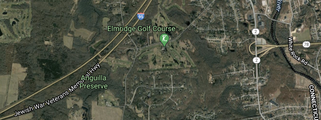
It would cut through Olde Mistick Village, Mystic Aquarium and a Pawcatuck golf course.
Olde Mistick Village is a shopping mall with poor spelling which is next to the Mystic Aquarium. Both are adjacent to the 340-foot-wide right-of-way for I-95 where the railroad would be sited. Cars in the distance? Fine. Trains? My heavens! The Pawcatuck golf course is in the path of Route 78, which was originally built to connect to the never-built Long Island-Westerly bridge. The golf course’s owner says: “I’m all for expanded rail, but we should use the right of ways that we already have.”
Guess what, that’s exactly what is being proposed! We have the right-of-way, and it connects right through your golf course. You chose to build a golf course in the direct path of a highway, what did you expect? (It’s worth pointing out that Alon suggests cutting from I-95 over to the existing right-of-way further east in Rhode Island to avoid a number of additional curves, negating this as an issue.)
But the NIMBYism goes on. Apparently, a new rail right-of-way along a highway would impact tourism.
“They’re going to have a fight on their hands,” said Joyce Resnikoff, co-owner of the 43-year-old Olde Mistick Village.
She said such a rerouting would be devastating to Mystic, which thrives on tourism.“I can travel all over the world and everyone knows Mystic,” she said. “We all work very hard to support tourism here. It’s big business.”
First of all, people from across the world do not all know Mystic. How a new non-stop train line would devastate tourism is also perplexing. It’s not like crowds of travelers on Acela today pile off the train to go to Mystic’s big businesses: no Acela trains stop there. Before covid-19, there were five trains stopping (a sixth was planned), with an average of 78 passengers per day. If high-speed trains were shifted to a separate alignment, it would allow a regional New Haven-to-Providence service to run hourly (or better) along the existing coastal line, with a lot more service and, probably a lot more ridership.
“We already have rail lines coming into our communities. To go in a different direction seems bizarre to me … I think their bigger step is to fix what they have.”
Slow rail lines. It’s hard to say what seems bizarre other than this guy is a town council member, not an engineer. What we have is unfixable.
The Southeastern Connecticut Council of Governments sent a letter …expressing its concerns about how [the alignment] would relate to or disrupt land use and environmental resources in the region and how any of the alternative routes could result in potentially fewer train stops in New London.
There are some environmental questions, although most of the right-of-way would be adjacent to the highway and already disrupted. Then there’s just complete misunderstanding of how the railroad works:
Stonington First Selectman Rob Simmons agreed, saying the disruption, huge cost and effort of the project would only save riders a few minutes. He said that when the existing line was electrified for high-speed trains, the Acela cars were designed to tilt so they could navigate the curved tracks in the region without slowing down.
The tilt mechanism helps to wring a few extra minutes out of the curvy route along the coast. It does not allow 180 mph operation on a line from the 1840s.
But there was a public meeting, and the pearl clutching really got going. We got to hear about how long people have lived somewhere:
Jeff Andersen, director of the Florence Griswold Museum in Old Lyme. Andersen has been working in Old Lyme for 40 years. “It’s an American treasure, and it needs to be protected and preserved,” said Andersen.
Did the Florence Griswold Museum complain when I-95 was built 1000 feet away? Probably not. But now that a train might be built in the same right-of-way, my heavens. It gets worse. Senator Blumenthal represents the local population, but should know better, especially since shaving 30 to 45 minutes off (more than “a few minutes”) would be a significant benefit for his constituents in New Haven and Stamford.
Old Lyme First Selectwoman Bonnie Reemsnyder said this is not about NIMBY, “Not In My Back Yard,” but “about our cultural and environmental survival in Old Lyme.”
Old Saybrook First Selectman Carl Fortuna said the proposed bypass would shift the location of his town’s train station, which the state and town have invested in and is considered the “economic center of town.”
In East Lyme, the route would proceed through several neighborhoods, a new 400-unit apartment complex and a proposed Costco, Flanders Four Corners and possibly a recently identified site of tribal significance, East Lyme First Selectman Mark Nickerson said.
Stonington First Selectman Rob Simmons said the new segment would bypass the Westerly train station and wipe out Mystic Aquarium, Olde Mistick Village and “the gateway” to Mystic, the state’s top tourism destination.
All of this wiping out of historic town centers (and Historic Costcos) is rather preposterous, since most of the line would be built within the existing highway right-of-way, which is generally 350 feet wide, plenty wide enough for a two-track railroad and a four-lane highway. This rhetoric, however, sank the planning process, so while we could have entered Infrastructure Week in the Biden Administration with a path forward to speed the Northeast Corridor, we’ll now have to start from scratch.
Part of the blame may go to the study’s authors, who included vague maps of the corridor which were probably not clear enough about which areas would and would not require property takings. And there is a valid concern about moving the train station in New London from Downtown to somewhere a bit further afield (although there are plenty of examples abroad of new train stations outside of old towns which maintain their legacy service).
Still, the lion’s share of blame should go to NIMBYism (it’s usually the case that if you have to start your sentence with “I’m not a NIMBY” you probably are one). It will take both better communications about what is actually going to happen (no, no one is going to bulldoze the Mystic Aquarium) as well as leaders who are willing to tell the truth to their constituents. It may even take some carrots (get on a train in New London, be in Boston in an hour). It will also take a system which allows construction costs that do not escalate to a point of oblivion: a 50 mile section of highway-ROW high speed rail with two major bridges should cost $2 billion, not $20. Before concrete, we’ll have to have organization to allay the fears of the North American NIMBY.