Don’t double down on the mistakes of the past: Cabot Yard edition

The Red Line derailment didn’t look too bad at first. The train stayed upright, there were no major injuries, and it appeared that the train would just have to be rerailed, the track repaired, and normal service would resume. The T did an excellent job setting up what skeleton service they could to bypass the site, providing rail service to Braintree and Ashmont without resorting to trying to put ten thousand people per hour on buses which would tie up half of the bus fleet (which is otherwise occupied at rush hour). It seemed the incident had happened in a relatively good location, one of the few where there was some redundancy, as passengers could just transfer from one side of the station to the other.

On Wednesday we found out just how bad it was. With the railcar finally removed (it is rumored that the reason the crane wasn’t placed on the Columbia Road bridge as originally proposed was because DCR didn’t know the maintenance level weight limit of the bridge and dropping the bridge on the Red Line would have been even worse) we saw what it hit. The little building next to the tracks housed the signal equipment for not only Columbia Junction—often dubbed Malfunction Junction, and that’s when the signal system works!—but several miles of track in either direction. Now the 14 trains per hour normally scheduled across the line—which are barely enough to handle rush hour traffic—are reduced to four to six, for the foreseeable future. It turns out that this derailment didn’t happen in a good location, but a bad one.

Signal systems are complex and bespoke, so a full replacement may take months or years to procure, if not longer. In 1996, when the Muddy River flooded into the Green Line, normal operations didn’t resume for months, and fixes for the system itself took years, and $40 million in repairs. The T now closes the Fenway portal during heavy rain events every few years to prevent a repeat of that situation. However, the proximate cause—flooding from the Muddy River—was a bigger issue: a century ago, the river was relocated in to culverts below Park Drive, and with only so much space in the culverts, it would back up along the Riverway during heavy rains, overtop the levee, and, once the D Line was built in 1959, pour in to Kenmore (which had happened in 1962 as well). This was eventually fixed as part of a 20-year project spearheaded by the Army Corps of Engineers and multiple other agencies, and with the new drainage in place, future flooding of the MBTA is less likely. Instead of continuing with the same reactionary system—where floodgates and sandbags were required every few years, and if they didn’t work, as occurred in 1996, the results would be catastrophic—we changed the larger ecosystem to one which would prevent the problem in the first place.

The Red Line derailment should serve as a similar wake-up call. Despite Governor Baker’s repeated calls for no new revenue, simply fixing the system we have won’t work. We—and I’m putting this in italics—can not continue to double down on the same system we have and expect different results. In the short term, this is going to require we invest in the system to make it more efficient and more resilient. In the long term, addressing wider problems will create the sort of system that will pay dividends when things like this week’s derailment occur less frequently and, when they occur, have less impact.

A short history of Cabot Yard and Columbia (a.k.a. Malfunction) Junction

The Red Line was the last of Boston’s subways to be built. The original segment operated between Harvard and Park and it was eventually extended, as the “Cambridge-Dorchester tunnel“, to Ashmont. At first, the only yard facility was on the north end of the line at the Eliot Shops, a complex of yards and shops tucked between Harvard Square and the Charles River, which is home to the Kennedy School today. When the line was extended in the 1920s, it added another yard—Codman Yard—past Ashmont station. For the next 50 years, the line would operate quite simply: trains would pull out of a yard beyond the terminal, service the line, and then pull into the yard at the terminal. This is optimal: the line requires no mid-line switches, and every train coming in or out of service simply pulls in to the first stop.

The 1970s and 1980s changed that. In 1965, the T purchased the Old Colony right-of-way to build an extension to Quincy and Braintree. This was originally planned to be an independent, express line (which is why there is no Braintree station at Savin Hill or Neponset) which would terminate at South Station. Eventually, it was aligned to be part of the Red Line, which required a new junction where the lines split at Columbia Road.

More importantly, it needed somewhere to store and service the cars. The Eliot Shops were small, cramped, and sat on valuable land eyed by Harvard for years. The T gave the land to Harvard in 1966 but needed to find a new location for its yards. The Ashmont Branch was out: Codman Yard was surrounded by housing. Braintree didn’t want a rail yard at the end of the line and blocked efforts for a yard there, so the T finally paid the Penn Central for the freight yards in South Boston to store Red Line cars. This was by no means their first choice: in order to access the line, trains would have to traverse nearly two miles of non-revenue track to get to JFK-UMass, and would then have to run the rest of the way back to Braintree to begin their inbound trips. (A small yard—called Caddigan, in keeping with an apparent rule that all Red Line facilities must begin with a hard C—exists past Braintree, but it can only store a few cars.)

This issue was exacerbated in the 1980s when the Red Line was lengthened once again. The line was extended from Harvard to Alewife, but was originally slated to go beyond. As late as 1977, the line was planned to Arlington Center (with an eventual extension) and the decision was made to curve the line past the Alewife station to aim towards Arlington, forgoing the ability to build a yard on then-vacant land just west of Alewife. The next year, the town decided it didn’t want rail service, but the deed was done, and no terminal was available at the north end of the line, either. (This was related to me by Fred Salvucci, who had some choice words for Arlington and Cambridge about this. I’ve written about an idea to build a yard below Thorndike Field beyond Route 2 to mitigate the terminal issues at Alewife.)

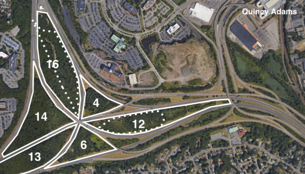
So Cabot is it. It serves most of the trips for the Red Line and is the only maintenance facility. It sits less than a mile from Downtown and the Seaport on what is undoubtedly valuable land. (The nearby MacAllen Building and its neighbor have 279 condos; the two northernmost portions of Cabot are about three times as big.) And Cabot is the main reason that the location where the train derailed—Malfunction Junction—is as complex as it is. In fact, the switch where the train derailed has nothing to do with splitting apart the branches of the Red Line, but rather a switch for a “yard lead” allowing trains to return to Cabot. The entire complex is conceptually designed quite well: it creates a series of “flying junctions”—not just between the two branches, but also for trains between the Braintree line and Cabot (most Ashmont trains operate out of Codman so therefore don’t require as frequent movement). This requires a series of complex switches and flyovers, but means that operationally no train ever has to cross another line.

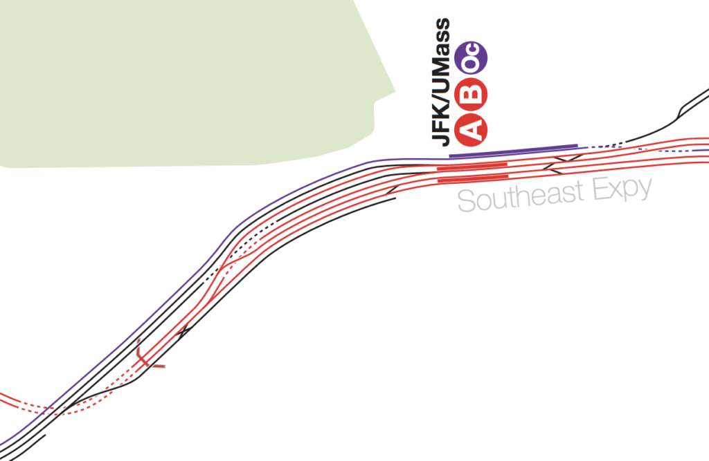
Columbia Junction. North (towards Downtown Boston) is at the left. A snippet of a full MBTA track map (the best MBTA track map!) which can be found here.

But Columbia Junction, as built, is a known problem spot and frequent cause of delays, and this doesn’t change the fact that Cabot is in the wrong geographic location for a rail yard. In Chicago, nearly every yard is at the end of the line, or close by (the last mid-route yard—Wilson—was decommissioned in the ’90s in favor of a yard at Howard). New York, DC and San Francisco rely on yards mostly built on the outlying portions of the line. The T specializes in mid-route yards for the Orange and Blue lines (Wellington and Orient Heights), but both are located adjacent to the line, not miles away.

Thus, Cabot Yard has four major problems:

  • It connects to the wrong part of the line for a rail yard
  • It is not even close to said line
  • Where it connects to the line it requires a series of complex switches
  • It sits on otherwise valuable land, probably the most valuable land of any heavy rail yard (setting aside Commuter Rail yards downtown which, while in sensible locations operations-wise, sit on huge parcels of valuable land and which could be freed up with a North-South Rail Link, but that’s the topic of another post entirely).
The T’s plan? Rebuild Cabot Yard and Columbia Junction. The cost? At least $200 million for Cabot, and another $50 million or more for Malfunction Junction. The benefits? Negligible. Fixing the switches will help, but Cabot would still requires long non-revenue movements to get trains to the wrong part of the line to provide service and uses high-value land to store rail cars. It’s cheaper in the short run than building a new facility, but doubles down on the same issues which require extraneous operations and needless complexity. Yet this is the Charle Baker “no new revenue” vision: keep investment minimal now, continue with the same system we have even when it clearly doesn’t work, and somehow expect a different result. 
The solution, of course, would be to build a new yard facility somewhere further south along the Braintree branch of the Red Line. The question is: where?
The Braintree Split

I wrote last year about how the optimal location for bus garages is probably on state-owned land adjacent to highways, rather than next to transit stations as the T is proposing at Wellington and Riverside. No one wants a bus yard in their backyard, and building bus lots next to train stations instead of transit-oriented development is doubly wrongheaded. While rail yards are more location-constrained than bus yards (since they have to physically connect to the railroad) there is some potential to leverage the same sort of arrangement of land in Braintree for the Red Line.

If the Braintree branch were being built today, a logical location for a yard would be at what is currently the Marketplace at Braintree development. When the line was built, this was an active rail yard (a small portion still is a freight yard), and the Red Line was built on the “wrong side” of the tracks to access this parcel. Using it today would require not only nearly $100 million to buy the land and businesses, but nearly-impossible negotiations to somehow reimburse Braintree for that commercial tax base. The site south of the Braintree garage has less value (about $25 million) but is also on the “wrong side” (the Red Line is east of the Commuter Rail to allow access to what is now the Greenbush Line) and would require some sort of flyover or duck-under to gain access, while being slightly smaller than Cabot. Further south, there are some potential sites, but these would require longer lead tracks and have potential wetland impacts and NIMBY implications.

A map showing the locations of the sites mentioned above.

There is a site near Braintree, however, which would have no acquisition cost, since the state already owns it. It would have no impact on the tax base, since it has no assessed value. It will never be suitable for residential or commercial development, since it sits inside a highway interchange. It is, of course, the land within the Braintree Split. The land in the “infield” of the Braintree Split amounts to about 70 acres, which is nearly four times the size of Cabot Yard. The interchange is a “Directional-T” interchange, and designed so that at its center, three roads cross each other at the same point. The are, from lowest to highest, the mainline route from 93 north to 93 north, from Route 3 north to 93 south, and from 93 south to Route 3 south. This is important, because it would impact how a potential rail yard could be linked together.

None of the parcels bounded by the Braintree Split is as large as the entirety of the Cabot Yard (about 18 acres), although Cabot itself is split roughly evenly by the 4th Street bridge between the maintenance facility and the storage yard. Four of the sectors are roughly the same size, two are significantly smaller. Given the topographical constraints, it would be easiest to link together the 16 and 12 acre parcels. The map below shows the parcels within the Split, the size of each in acres, and, superimposed with dashed lines on the 16- and 12-acre parcels, the outlines of the Cabot shops facility and storage yard, respectively, with dashed lines.

Braintree Split parcels, with the Cabot shops and yard superimposed on the 16- and 12-acre parcels.

The Braintree Split is not as optimally located as, say, the site south of the Braintree station. It’s a bit further from the Red Line, and not at the end of the line, so some deadhead movement would be required to reach the terminal. But it’s considerably closer to both the end of the line in Braintree and to the line itself. The closest portion of the 12-acre parcel is only about 0.25 miles from the Red Line tracks, although there are some roadway ramps in between. (There are plenty of examples of rail yards interacting with highways, like the WMATA West Falls Church yard in Virginia, 98th, Rosemont and Des Plaines yards in Chicago,  and South Yard in Atlanta.

It is worth noting that Braintree Split isn’t exactly flat. If you drive from 93 south to Route 3 south, you descend from an elevation of 180 feet down to 40 feet. Rail yards have to be flat (so, you know, unmanned trains don’t roll away if their brakes fail), and rail grades, even for a rapid transit line, should be at most two or three percent. Given that the 12-acre parcel is lower than the 16-acre parcel, the two would have to be used for separate facilities, but there is no reason that the 12-acre parcel couldn’t host a storage yard with shop facilities at the 16-acre parcel. In fact, the 12-acre site is better suited for a storage facility (since it is long and narrow) while the 16-acre site would have plenty of room for a maintenance facility and potentially additional storage tracks, which might be necessary if the Red Line were one day improved to offer service every three minutes.

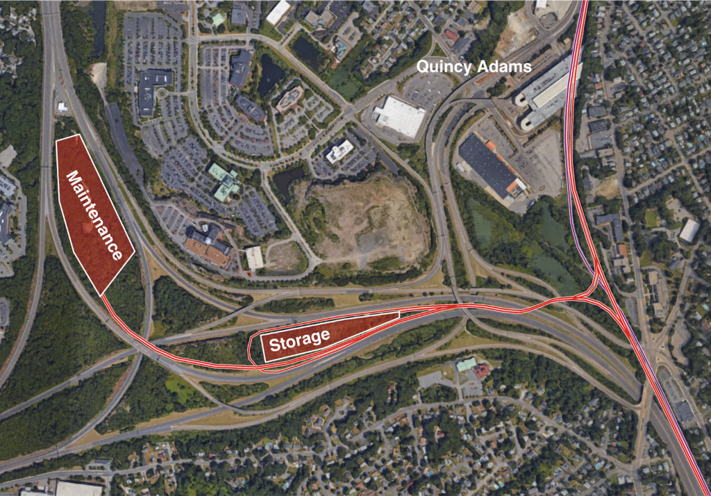
This would require about 1400 feet of lead tracks from the Red Line to the storage yard, and no new land acquisition as all would be built on land already owned by the state. The yard lead would extend flat over the first set of ramps and Route 3 north (the Red Line climbs at about a 3% grade out of Quincy Adams to cross over the Old Colony Commuter Rail), and would then descend down to the level of Route 3 to pass over the northbound Burgin Parkway ramp and under the southbound one. There it would split in to two, with one set of tracks leading to a level storage facility and the other extending up to the maintenance facility further north. Access to the maintenance yard would be available from near the zipper lane facility just north of the split, although parking might be better provided on the side of the highway with a pedestrian bridge for workers to access the yard. If funds were available from nearby developers, these walkways could even allow a station to provide better access to nearby office buildings to provide a shuttle service from Quincy Adams or Braintree.

Simplifying Columbia Junction and Savin Hill


There are other knock-on effects to simplifying Columbia Junction and relocating Cabot Yard.

In addition to the Old Colony Commuter Rail line running through a single-track bottleneck south of JFK-UMass (which is part of the reason only a few extra trains can be run at rush hour), there is a bottleneck on I-93 there as well. In 2012, CTPS developed a concept to add HOV lanes to I-93 and a track to the Old Colony lines (thereby removing a single-track bottleneck) near Savin Hill by burying both the Old Colony and the Red Line for the better part of a mile. Yet this concept would likely rival the Allston I-90 project in complexity and cost.

With South Coast rail now being (wrongly, in my opinion) pushed down the Old Colony Line, the FMCB has considered a similar plan. Yet this is based on the false premise that four tracks need to be provided to JFK/UMass, which is mostly required to allow access in and out of Cabot Yard from the Braintree Branch. Without the need to access Cabot Yard via a flying junction, there is no need for four tracks through Savin Hill: by combining the two Red Line branches south of Savin Hill, one of the existing Red Line tracks could be used for Commuter Rail through the Savin Hill bottleneck with only some minor modifications, at least relative to the state’s incoherent plan. In addition, by replacing Cabot Yard with a facility in Braintree, the entirety of “Malfunction Junction” could be replaced by two switches, one to split the southbound main line in to two branches, and another to combine the two northbound tracks together.

The sketches below show the current configuration of the railroads adjacent to Savin Hill, and a proposed concept. The proposed concept would have outbound trains stop at Savin Hill, but inbound trains on the Braintree Branch (which has less capacity) would bypass Savin Hill and merge in past the station (as they do today), although it could certainly be realigned to allow all trains to serve Savin Hill. North of this junction, the Red Line would operate as a simple, two-track railroad through to Andrew and on to Downtown and Alewife. Inbound passengers at JFK/UMass would no longer have to play platform roulette, or stand on the overpass and wait for the next train, as all service would take place on a single platform.

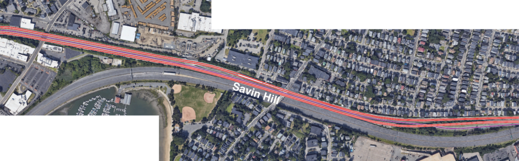
Current track layout.

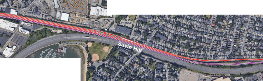
Proposed track layout showing the combination of the Red Line branches moved further south.

The Cabot Yard leads and Track 61


The tracks from JFK/UMass to Cabot would not have to go unused, however. I pointed out several years ago that Track 61 could reasonably be connected to Andrew Station to provide a shuttle from JFK/UMass to the BCEC and Seaport. With the Cabot yard leads freed up, such a shuttle could instead run from JFK/UMass to the BCEC, providing a connection from Dorchester and the South Shore to the Seaport without relying on the overburdened Silver Line. There should be enough room for two light rail tracks from JFK/UMass to the Seaport (with a single-track terminal at JFK, much like the Braintree branch of the Red Line is being operated after the derailment) with the other Red Line track given over to the Commuter Rail. This would provide a useful link using the otherwise-excess right-of-way.


Cabot Yard as midday layover for Commuter Rail

While Cabot Yard is poorly-located as a Red Line facility, it is in the right place for midday Commuter Rail storage. This page is on the record saying that the best way to reduce the need for midday storage is to just run more trains, but peaks will be peaks, and having somewhere near a terminal to store trains will be important until we build the North South Rail Link (in which case trains will be able to run through the tunnel to outlying yards, freeing up land near the terminals). Today, the Commuter Rail system uses yards at Southampton (near Cabot) and Readville (at the end of the Fairmount Line, so not near Cabot, or really anything) for midday train storage.

Yet to run more trains, the agency needs more storage, so it is looking at sites in Allston and Widett Circle, despite the expense of building in these locations and their desirability as development sites. (As a participant in the planning process for Allston, the supposed need for storage drives many undesirable and expensive portions of that project.) If Cabot Yard was vacated by the Red Line, it would make a fine facility for midday storage: it’s very close to South Station and, with a rail yard on one side and bus yard on the other, a less-desirable development site. The portion of the facility between the Haul Road and 4th Street is more than double the size of Readville, and could thus replace Readville entirely while providing enough additional capacity to obviate the need for new construction in Allston or at Widett Circle.

Conclusion

As usual, actions taken in one location decades in the past cascade through the entire transportation network. NIMBYs in the 1960s pushed the T to build Cabot Yard, even if it was nowhere near the Red Line itself. A changing economy means that the land it occupies, which was little more than a post-industrial wasteland in the 1970s, is now worth hundreds of millions of dollars. The Braintree Split, built in the 1950s, provides enough room for a rail yard in its median. Malfunction—er, Columbia—Junction has always been a solution looking for a problem. By thinking pretty far outside the box, we could correct many of the mistakes of the 1970s. But it involves making an investment in infrastructure beyond just fixing what we have.

The current administration, it seems, is willing to double down on the mistakes which got us in to this mess. When the Muddy River flooded in to the Green Line, we didn’t just build a storm barrier and hope that it would work. We looked upstream for the cause, and rebuilt the Muddy River to keep it from overflowing in the first place. While the reactive solution might seem cheaper today, in the long run, unless we take proactive, decisive action, we’ll pay for the mistakes again and again.

Kudos, MBTA, on a job well done.

It’s not particularly frequent that I write (or anyone else writes) a blog post praising the MBTA (although it’s probably less frequent than it should be; the agency does a lot of good work with an old system and all-too-often inadequate funding and support) but today that is exactly what I am going to do regarding the Harvard-to-Alewife shuttle.

Some background: in 2016 I wrote a blog post about how the Harvard-Alewife shuttles could be improved. I noticed it mostly because I was on a training run for Boston (two weeks before my brush with death/fame, but I digress) and ran along Alewife Brook Parkway before taking a bus back to Harvard from Alewife. That was also for the floating slab project which has been with us since, well, at least 2011, and it sounds like the infrastructure will require continued maintenance forever, or at least until the MBTA installs a signal system which allows single-track operation (a regular occurrence for maintenance in Chicago and Washington, D.C.).

My advice went unheeded at the time. When the project came up again this fall, we (TransitMatters; if you haven’t already, become a TM member or apply for our first ever staff position) went all in. We contacted the T, city officials in Somerville and Cambridge, and wrote about it in Commonwealth. The idea is mostly sound. The pushback from the T—which we heard through intermediaries—was twofold, although any problems seemed easily solved:

  • First, they argued that it would adversely affect Alewife-Davis passengers (a valid concern, although I had someone who works with the MBTA looking at how shutdowns affect ridership look at some numbers, and these passengers account for a very small number of overall ridership, as would be expected), which could be mitigated by a single shuttle from Alewife to Davis. 
  • Second, that having buses going to multiple destinations would confuse passengers. Less valid, in my opinion. Apparently a train stopping three stops short of is normal terminal isn’t confusing, but buses with different destinations is? Or as a friend put it: “people can figure out the difference between Alewife and Braintree, right?”

In any case, on Saturday, December 1, the last day of the floating slab project, I got a message from a TransitMatters member: the T was sending buses out to different termini. Some were going to Davis. Some all the way to Alewife. I had been out of Cambridge, but once home I jumped at the opportunity to Hubway (or BlueBike) over to the Harvard Station to check it out. I wanted to see for myself. I wanted the rumor to be true. Alas, when I got there, the buses were operating “normally.”

But I noticed a peculiar difference: rather than being signed for Alewife Sta one of the buses was signed for Alewife Sta via Porter and Davis. If nothing else, this was an improvement in customer information: rather than just the terminal, it showed all of the bypassed stations. By the time I arrived, ridership was relatively low: only about 100 passengers per train, which were handled by two buses, which would be called in to the busway by inspectors as trains arrived. I was somewhat disappointed: I wouldn’t get to see the new system in practice, and that it would only live on as a rumor from a busier time of day. Nor would I be able to commend the T on trying something new. Again, just a rumor on the Internet.

So I walked down the ramp towards the pit, when I noticed a stack of papers sitting on the edge of a trash can (it was above the rim, and, no, I didn’t eat it). My curiosity piqued, I picked one up and read it. What had I’d stumbled upon?

Operator Guide: Harvard – Alewife

Saturday, December 1: 12 PM to 3 PM

We are testing a new Harvard – Alewife shuttle to use buses more efficiently and to provide a better service to our customers. There are a total of 3 different shuttle routes during this time period. A station official will let you know which route to begin when you are arrive at Harvard or Alewife.

The document went on to describe the three routes in detail, the head signs to use (this described the signage I’d seen earlier) and the fact that it had been observed earlier, but not when I was there. The details are that the T rather ingeniously came up with three routes to provide customers routes without sending all of the buses to Alewife. One route ran express from Harvard to Alewife. A second ran from Harvard to Alewife making all stops. A third ran to Davis Square only. While not as efficient as what I had proposed, it was a good balance of customer service and efficiency. I was very impressed, and I hope the test went well.

The skeptic will say “so why didn’t they try this earlier?” I’ll cut the T a lot of slack here. Transit agencies are large bureaucracies, and like ocean liners, they take some time to change course. In this case, they not only had to create this document, they had to vet the route, change the buses sign codes, and communicate with the various officials involved. Could it have happened faster? Maybe. Could it have not happened at all? Most certainly: that’s the easiest thing to do.

Maintenance shutdowns happen. They’re a necessary evil, but they’re an opportunity to experiment. ( (* see below for some brief suggestions) Unfortunately, experimentation is often something anathema to organizations like the MBTA. It takes extra effort for an often overworked staff, and even if the potential payoff is high, the willingness to fail is often low. But in this case, the MBTA tried. I would hope that it was successful, and that it will be the basis for better shuttle services for future floating Slab work, and elsewhere on the system going forwards.

So o everyone involved in the planning and operations staff at the MBTA: kudos and thank you. It’s always a risk to try something new. And to listen to some guy ranting on the Internet. You did both. I hope it worked. I hope that it will work in the future, and that the T use these sorts of situations to try new things to continue to provide the best possible service to its customers.

* Some suggestions for future experiments …

  • When the D Line is shut down from Kenmore to Reservoir, run a local shuttle bus along the route, but encourage through passengers to use the C Line from Cleveland Circle and allow fares (easiest would be to collect no fares west of Reservoir).
  • When the Orange Line is shut down past Ruggles, run every bus terminating at Forest Hills through to the start of Orange Line service, reducing the number of bus-shuttle-subway transfers by allowing passengers on buses to Forest Hills a one-seat ride to the Orange Line trains.
  • When the Green Line is shut next summer from Newton Highlands to Riverside, run alternating buses to Woodland and Riverside, instead of making every Riverside passenger make the tedious loop in and out of the Woodland station.) 
  • If the Lowell Line is shut down on weekends in the future, immediately fire anyone who proposes whatever the bus route used this fall was. Instead run buses from Lowell to Anderson/Woburn and then express to Boston, and serve the rest of the line with the adjacent 134 bus, with a couple of trips added as necessary to supplement service.

Extend Red-Blue to … Kendall?

At some point on the Internet, I’ve scoffed at the idea of extending the Blue Line across the Longfellow Bridge (somehow) and then run along Main Street to some superstation at Kendall (which there’s not room for) and then making a turn on the Grand Junction right-of-way (or something). I still do. You couldn’t reliably run the Blue Line and Red Line together on the Longfellow and they have separate loading gauges so would need different tracks at Kendall. To facilitate a Red-Blue Connector, it makes sense to stub-end the Blue Line at Charles Station and provide an easy answer to Kendall Square.

Or does it?

This would be a short and pointless blog post if the first paragraph was 100% true. Plus, I’ve written that blog post before. Twice.

One of the trickiest things about the Red-Blue Connector is shoehorning a good, useful terminal in to the space under Charles Circle. It’s not easy. You’d have to dig a wide tunnel, or long tail tracks, or dig out pocket tracks or tail tracks under a busy roadway and the supports for the Red Line. It would be somewhat difficult to build any sort of functional terminal: there’s just not the space. You could put something under Storrow Drive (technically Embankment Road) and Ebersol fields, which would result in a decent terminal, but you’d have to dig up and rebuild the fields, and you’d be digging adjacent to the river. It would provide for good operations; you could stack in several tracks for layover, storage and recovery, rather than using crossovers and/or the Bowdoin Loop.

So Ebersol would work for operations, but you’re still pushing more people in to the Red Line and the already-overburdened Kendall and Charles stations, and forcing every Kendall-bound Blue Line passenger to transfer (albeit an easier transfer than exists today). There’s another potential terminal. It’s bigger than Ebersol, would allow increased capacity across the Charles, the potential for further expansion and, oh, yeah, it’s already somewhere where a huge hole is going to be built in the near term.

I’m speaking of the Volpe site recently bought by MIT. Since they’re going to be digging a big hole, it would make sense to put something useful in it, not just more parking. It is an extra 3000 feet to tunnel from Charles Circle to Volpe, but it’s mostly in a shallow river and free from utility considerations (as far a I can tell). In theory, this should be relatively cheap tunneling: it could be done in a similar manner to the Ted Williams Tunnel: building tubes off-site, digging a trench, and sinking the tubes in to place, except downscaled by a significant factor: the width of two Blue Line trains is narrower than two highway lanes. The river is 12 to 15 feet deep just downstream of the Longfellow, so it would need to be excavated down about that much to accommodate current depths. The TWT required digging through muck and in to bedrock at times to accommodate a shipping lane clearance at low tide, but the Charles has no such river traffic. The disposal and mitigation of the sludge on the river bottom may be the trickiest part, although it would be beneficial to start cleaning up the muck on the bottom of the Charles River.

Then there’s the Broad Canal. This should be easy. It’s 15 feet deep, doesn’t need clearance for anything more than kayaks (although the waste heat from the power plant would have to be accounted for), and could be easily coffer-dammed, dug out, cleaned up, and filled in with several feet of water sheet above. To make up for any displaced water volume (hello, Waters of the United States), the canal above could be extended, Lechmere-style, to a water feature figuring in prominently in the new Volpe development.

What does this get you? A lot, actually. First of all, designing a subway loop terminal in Volpe’s basement would add minimal marginal cost to the development and would make it extremely transit-oriented, and add value to the project: there’d be no need to trek through the Marriott to Kendall Square to the Red Line for trips downtown. (Do you need a loop? Probably not, but if you can get MIT to dig the hole, you might as well put a good terminal down there, although if you wanted to run trains through to Binney and beyond in the future, you could build a simpler island platform with tail and storage tracks beyond.) This north/east side of Kendall is booming. In the past 10 years, several blocks have been rebuilt from gravel lots to job sites and residential developments: below is the same corner in 2011 and 2017, for instance. It would also bring transit a bit closer to the no-man’s-land in the mile between Kendall and Lechmere. With Volpe as the linchpin of several thousand more jobs and residents, expanding transit should be a priority in Kendall.

2011
2017

This plan would also give the Kendall area a direct connection to more of Downtown Boston, East Boston, the HYM Suffolk Downs site Boston is proposing for Amazon (but will be developed no matter where Amazon goes), and, most importantly, the airport (this could—maybe—provide the impetus to build a better connection to the airport from the Blue Line). It would provide more capacity across the Charles—although the north-of-Boston portion Red Line is most full from Central to Kendall—and more importantly would take some traffic out of the Kendall Station, which was never really designed for the number of people using it today.

Further down the road? The Volpe site hemmed in by Biogen to the west, but a right-of-way could be preserved over to Binney Street where a further extension could easily reach the Grand Junction. From there, much is possible. A line to Sullivan Square and Assembly via the Grand Junction. A line in the other direction linking Kendall to Allston, and then further west. Once GLX is complete, the Blue Line will be the only transit line which terminates in Downtown Boston, which is operationally inefficient. This would give it a terminal at both ends to improve operations.

I’m not sure how much this costs; I haven’t been able to find a good breakdown of the order-of-magnitude for the costs for the TWT. (I did speak to Fred Salvucci about it, and he said it was the cheapest and easiest part of the Big Dig to build, although that’s a pretty low bar.) I also can’t find information about the specific cost of the “Haymarket North Extension” tunnel costs, but that project seemed not to have broken the bank (as far as I can tell, the below-ground portion of that line did not use boring machines). Searching the Globe archives, the entire Haymarket North project cost $180 million at the time, equivalent to $750 million today. That number includes: the five miles of the line to Oak Grove, some tricky engineering building between buildings from Haymarket to the river, and the B&M holding up the state for $18 million ($95 million today) to build the line through Charlestown (This is more than half, considering 1970s inflation, of what the state would pay a couple years later to buy the entirety of the Boston and Maine lines in Massachusetts east of Fitchburg: $39.5 million, $170 million today). For this proposal, the state would only have to negotiate over a small portion of Broad Canal Way, and its owner—an REIT—would stand to benefit from better transit to the airport so might be willing to make the price right.

In any case, if Charles Station was built as a through station and not a terminal, it would reduce construction costs there (where they’re expensive) and improve operations. The station could even be built with side platforms to keep the width of the subway narrower. The Volpe terminal could be built basically for free if it was integrated in to the overall Volpe development. The question comes down to the cost of the underwater tunnel. If it’s reasonable—and it seems that it would be—this would make a lot of sense. What about transfers from further north on the Red Line? This would preserve the full functionality of the Red-Blue connector, except it would work even better. And if the North South Rail Link ever obviated the need for the Grand Junction to function as a freight corridor, the Blue Line could easily be extended west or north.

Thinking Big? Let’s Think “Realistic” First

The MBTA’s Fiscal and Management Control Board, according to their slides, wants to “think big.”

Thinking big is a laudable goal. The only problem is that big thinking requires feasibility, and it is a waste of everyone’s time and energy if the big thinking is completely outside the realm of what can reasonably occur or be built.

Case in point: combining Park Street and Downtown Crossing into one “superstation.” The first reason this won’t happen is that it doesn’t need to happen: with the concourse above the Red Line between the two stations, they are already one complex. (#Protip: it’s faster to transfer between the Red Line at Park and the Winter Street platform on the Orange Line—trains towards Forest Hills for the less anachronistic among us—by walking swiftly down the concourse rather than getting on the train at Downtown Crossing.) But there are several other reasons why this is just not possible.

Tangent track

To build a new station between Park Street and Downtown Crossing would require tangent, or straight, track. If you stand at Park, however, you can’t see Downtown Crossing, because the tracks, which are separated for the center platform at Park, curve back together for the side platforms at Downtown Crossing. This curve is likely too severe to provide level boarding, so the track would have to be realigned through this segment. So even if it were  easy to build a new complex here, the tracks would have to somehow be rebuilt without disrupting normal service. That’s not easy.

Winter Street is narrow. Really narrow.

The next, and related, point: Winter Street is very narrow: only about 35 feet between buildings. Park Street Station is located under the Common, and the Red Line station at Downtown Crossing is located under a much wider portion of Summer Street: those locations have room for platforms. Winter Street does not. Two Red Line tracks require about 24 feet of real estate: this would leave 5.5 feet for platforms on either side before accounting for any vertical circulation, utilities and the like. Any more than that and you’re digging underneath the century-old buildings which give the area its character. That’s not about to happen. And Winter Street would be the only logical location for the station; otherwise it would force long walks for transferring passengers.

Summer Street (foreground) is wide.
Winter Street (background) is narrow.
The fact that so many streets change names crossing Washington?
Well, that’s just confusing.

Note the photograph to the right. The current Downtown Crossing station is located between Jordan Marsh on the left and Filene’s on the right (for newer arrivals: the Macy’s and the Millenium building), where Summer Street is about 60 feet wide, enough for two tracks and platforms, and it’s still constrained, with entrances in the Filene’s and Jordan Marsh buildings. Note in the background how much narrower Winter Street is. This isn’t an optical illusion: it’s only half as wide. The only feasible location for such a superstation would be between the Orange and Green lines, but the street there is far too narrow.

Passenger operations

The idea behind combining Downtown Crossing and Park Street is that it would simplify signaling and allow better throughput on the line operationally. But any savings from operations would likely be eaten by increased dwell times at these stations. At most stations, the T operations are abysmal regarding dwell times; Chicago L trains, for example, rarely spend as much time in stations as MBTA trains do, as the operator will engage the door close button as soon as the doors open. At Park and Downtown Crossing, however, this is not the case. Long dwell times there occur because of the crowding: at each station, hundreds of passengers have to exit the train, often onto a platform with as many waiting to board. This is rather unique to the T, and the Red Line in particular, which, between South Station and Kendall, is at capacity in both directions. Trying to unload and then load nearly an entire train worth of passengers at one station, even with more wider doors on new cars, just doesn’t make sense.

If Park and Downtown Crossing were little-used stations, it would make no sense to have two platforms 500 feet apart, and combining them, or just closing one, would be sensible. (Unlike New York and Chicago, the Boston Elevated Railway never built stations so close that consolidation was necessary.) But they are two of the busiest stations in the MBTA system, both for boardings and for transfers. Given the geometry of the area, both above and below ground, calling this a big idea is risible. Big ideas have to, at least, be somewhere in the realm of reality. Without a 1960s-style wholesale demolition of half of Downtown Boston, this is a distraction. The FMCB has a lot to do: they should not spend time chasing unicorns.

Better Headways? Geometry gets in the way, not just signals.

In addition to a spending time on infeasible ideas like combining Park and Downtown Crossing, the FMCB and T operations claims that it would only take a minor signal upgrade (well, okay, any signal upgrade wouldn’t be minor) to allow three minute headways on the Red Line. Right now, trains come every 4 to 4.5 minutes at rush hour (8 to 9 minutes each from Braintree and Ashmont); so this would be a 50% increase. Three minute headways are certainly a good idea, but the Red Line especially has several bottlenecks which would have to be significantly upgraded before headways can progress much below their current levels. New signals would certainly help operations, but they are not the current rate limiting factor for throughput on the line.

There are four site-specific major bottlenecks on the line beyond signaling: the interlocking north of JFK-UMass (a.k.a. Malfunction Junction), the Park-Downtown Crossing complex, the Harvard curve, and the Alewife terminal. (In addition, the line’s profile, which has a bi-directional peak along its busiest portion, results in long dwell times at many stations.) Each of these is it’s own flavor of bottleneck, and it may be informative to look at them as examples of how retrofitting a century-old railroad is easier said than done. This is not to say that a new signaling system shouldn’t be installed: it absolutely should! It just won’t allow for three minute headways without several other projects as well. From south to north:

JFK-UMass

This is likely the easiest of the bottlenecks to fix: it’s simply an interlocking which needs to be replaced. While the moniker Malfunction Junction may not be entirely deserved (the Red Line manages to break down for many other reasons), it is an inefficient network of special track work which dates to the early 1970s and could certainly use an upgrade. In fact, it probably would be replaced, or significantly improved, with the installation of a new signal system.

Park/Downtown

Right now, Park and Downtown Crossing cause delays because of both signaling and passenger loads. For instance, a train exchanging passengers at Downtown Crossing causes restricted signals back to Charles, so that it is not possible for trains to load and unload passengers simultaneously at Park and Downtown Crossing. Given the passenger loads at these stations and long dwell times at busy times of day, it takes three or four minutes for a train to traverse the segment between the tunnel portal at Charles and the departure from Downtown Crossing, which is the current rate-limiting factor for the line. If you ever watch trains on the Longfellow from above (and my new office allows for that, so, yeah, I’m real productive at work), you can watch the signal system in action: trains are frequently bogged down on the bridge by signals at Park.

A new signal system with shorter blocks or, more likely, moving blocks would solve some of this problem. A good moving block system would have to allow three trains to simultaneously stop at Park, Downtown Crossing and South Station. So this would be solved, right? Well, not exactly. Dwell times are still long at all three of these stations: as they are among the most heavily-used in the system. Delivering reliable three-minute headways would help with capacity, but longer headways would lead to cascading delays if trains were overcrowded. There’s not much margin for error when trains are this close together. Given the narrow, crowded stairs and platforms at Park and Downtown crossing, the limiting factor here is probably passenger flow: it might be hard to clear everyone from the platforms in the time between dwells. And it is not cheap to try to widen platforms and egress. A new signaling system would help, but this still may be a factor in delivering three minute headways.

The Harvard Curve and dwell times

Moving north, the situation doesn’t get any easier to remedy. When the Red Line was extended past Harvard, the President and Fellows of Harvard College would not allow the T to tunnel under the Yard, so the T was forced to stay in the alignment of Mass Ave. This required the curve just south of the station, which is limited (and will always be limited) to 10 miles per hour. The curve itself is about 400 feet long, but if any portion of the train (also about 400 feet long) is in the curve, it is required to remain at this restricted speed. So the train has to operate for 800 feet at 10 mph, which takes about 55 seconds to operate this segment alone. Given that with Harvard’s crowds, it has longer dwell times due to passenger flow, traversing the 800 feet of track within the station and tunnel beyond takes more than two minutes under the best of circumstances.

Would signaling help? Maybe somewhat, but not much. Even a moving block signal system would not likely allow a train to occupy the Harvard Platform with another train still in the curve. Chicago has 25 mph curves on the Blue Line approaching Clark/Lake and operates three minute headways, but they also frequently bypass signals to pull trains within feet of each other to stage them, something the T would likely be reticent to do. It may be possible to operate these headways but with basically zero margin for error. Any delay, even small issues beyond the control of the agency, would quickly cascade, eating up any gains made from running trains more frequently. This is a question of geometry more than anything else: if trains could arrive and leave Harvard at speed, it wouldn’t be an issue. But combining the dwell time and the curve, nearly the entire headway is used up just getting through the station.

Alewife

The three issues above? They pale in comparison to Alewife. Why? Because Alewife was never designed to be a terminal station. (Thanks, Arlington.) The original plan was to extend the Red Line to 128, with a later plan to bring it to Arlington Heights. But these plans were opposed by the good people of Arlington, and the terminal wound up at Alewife. The issues is that the crossover, which allows trains to switch tracks at the end of the line, didn’t. It wound up north of Russell Field, along a short portion of tangent track between the Fitchburg Cutoff right-of-way and the Alewife station, and about 900 feet from the end of the platform. If a train uses the northbound platform, it can run in to the station at track speed (25 mph, taking 50 seconds), unload and load at the platform, and allow operators to change ends (with drop back crews, this can take 60 seconds), and then pull out 900 feet (25 mph, taking 30 seconds) and run through the crossover at 10 mph (45 seconds). That cycle takes 185 seconds, or just about three minutes, of which about a minute is spent traversing the extra distance in and out of the station. If the train is crossing over from one track to the other would foul the interlocking, causing approaching trains to back up. And since this is at the end of the line, there’s significant variability to headways coming in to the station, so trains are frequently delayed between Alewife and Davis waiting for tracks to clear.

Without going in to too much detail, the MBTA currently has a minimum target of about 4 minute headways coming out of Alewife. Without rebuilding the interlocking—and there’s nowhere to do this, because it’s the only tangent portion of track, and interlockings basically have to be built on tangent track—there’s no way to get to three minute headways. In addition, the T is in the enviable position of having strong bidirectional ridership on the Red Line. In many cities, ridership is unbalanced: Chicago, for example, runs three minute headways on their Red Line from Howard at peak, but six minutes in the opposite direction from 95th (this results in a lot of “deadheading” where operators are paid to ride back on trains to get back to where they came from). The T needs as many trains as it can run in both directions, so it has to turn everything at Alewife (never mind the fact that there’s no yard beyond; we’ll get to that). This also means that T has to run better-than-5-minute headways until 10 a.m. and 8 p.m. to accommodate both directions of ridership. While this means short wait times for customers, it incurs extra operational costs, since these trains provide more service than capacity likely requires and, for instance, we don’t need a train leaving Alewife every four minutes at 9:30, except we have to put the trains somewhere back south.

In the long run, to add service, Alewife is probably unworkable. But there is a solution, I think. The tail tracks extend out under Route 2 and to Thorndike Field in Arlington. The field itself is almost exactly the size of Codman Yard in Dorchester. Assuming there aren’t any major utilities, the field could be dug up, an underground yard could be built with a new three-track, two-platform station adjacent to the field (providing better access for the many pedestrians who walk from Arlington, with Alewife still serving as the bus transfer and park-and-ride), a run-through loop track, and a storage yard. I have a very rough sketch of this in Google Maps here.

Assuming you could appease local population and 4(f) park regulations, the main issue is that field itself is quite low in elevation—any facility would be below sea level and certainly below the water table. But if this could be mitigated, it would be perhaps the only feasible way to add a yard to the north end of the Red Line. And it is possible that a yard in Arlington, coupled with some expansion of Codman (which has room for several more tracks) could eliminate the need for the yard facility at Cabot Yard in Boston, which is a long deadhead move from JFK/UMass station. While the shops would still be needed the yard, which sits on six acres of real estate a ten minute walk on Dot Ave from Broadway and South Station, could fetch a premium on the current real estate market.

This wouldn’t be free, and would take some convincing for those same folks in Arlington, but operationally, it would certainly make the Red Line easier to run. Upgrades to signals and equipment will help, but if you don’t fix Alewife, you have no chance of running more trains.

Overall, I’m not trying to be negative here, I’m just trying to ground ideas in realism. It’s fun to think of ways to improve the transit system, but far too often it seems that both advocates and agencies go too far down the road looking in to ideas which have no chance of actually happening. We have an old system with good bones, but those bones are sometimes crooked. When we come up with new ideas for transit and mobility, we need to take a step back and make sure they’ll work before we go too much further.

Today’s glossary:

  • Deadhead: running out of service without passengers. All the cost of running a train (or, if an operator is riding an in-service train, all the costs of paying them), none of the benefits.
  • Headway: the time between train arrivals
  • Tangent track: straight track

Editor’s note: after a busy first half of the semester, I have some more time on my hands and should be posting more than once every two months!

A more efficient Alewife-Harvard shuttle could save $30,000 per day

I had the opportunity yesterday to ride the rail-replacement shuttle from Alewife to Harvard. (I’m not faulting the T for such shutdowns at all, maintenance needs to happen.) But the buses are run very inefficiently, and if the route was changed, it could halve the number of buses required to provide the service, cutting the cost of operating these buses by tens of thousands of dollars, and provide better service for most riders.

The issue is that while Alewife is a pretty straight shot from Harvard by rail, it isn’t by road. Somerville pushed hard to have Davis included in the Red Line extension in the 1980s, and the subway follows the old Fitchburg Cutoff from Davis to Alewife, less than a mile. But the bus route is longer: it runs out from Davis to Teele Square and Clarendon Hill, then turns on to the narrow-laned Alewife Brook Parkway (going inbound, this is a very tight turn for buses; the bus I was on was forced to drive over the sidewalk to make it) before running through the mess of an intersection at Route 2 and on to Alewife, a distance of more than two miles (with half a dozen traffic lights). And the buses here are mostly empty: on weekends, relatively few passengers board at the park-and-ride Alewife, with more coming from Davis and Porter squares.

Here’s how the buses operate currently (approximately):

0:00 leave Harvard Square
0:06 leave Porter Square
0:11 leave Davis Square
0:24 arrive Alewife

From Porter and Davis, this only amounts to a three to five minute delay versus the subway (plus a transfer penalty and traffic). From Alewife, however, it’s closer to a fifteen minute delay, since the trip from Davis takes so long. And even though the buses rumbling along Alewife Brook Parkway are mostly empty, the cost of operating a bus is the same whether it has 60 passengers on board or six, and there are often four empty buses lined up in a traffic jam on Alewife Brook Parkway waiting for the long light cycle at Mass Ave or Route 2.

Let’s assume the T uses 4 buses per train and that there’s a train every 8 minutes. That would mean that with a 48 minute round-trip operation time, there would be 24 buses on the route at any given time (this doesn’t include schedule recovery time at either end of the line, and turning time at the Bennett Alley end of the Harvard Tunnel, which are the same in both scenarios). Imagine if, instead, you had the following:

  • Three buses leave Harvard with a destination of Davis stopping at Porter. With a busway, buses are able to turn at Davis, and by stopping in the busway will provide better passenger amenities there and provide a single stop in Davis.
  • One bus leaves Harvard to Alewife. This bus could either run directly to Alewife via Concord Ave, or out to Porter on Mass Ave and then via Rindge to Alewife (coming back, buses would have to use the Concord Ave routing to get to Harvard). This is about a 10 or 11 minute trip.
So, instead of every bus making a 48 minute round trip, each bus would make a 24 minute round trip. In other words, rather than every bus operating 4 miles from Harvard to Alewife, each bus would operate just 2 miles. Just like that, you’d need half as many buses to provide the same—or better—level of service, doubling the efficiency.
For Alewife riders, few are making a short trip to Davis; most are going at least to Harvard or further on the Red Line. These riders would save several minutes—even with less-frequent service—with a direct trip. Passengers going from Alewife to Porter or Davis would have a longer trip and a transfer, but there are few such riders; for the large majority passengers, the trip would be as fast or faster. The service would be slightly more complex, but could easily be explained by staff—who are present at every station during these diversions—and signage.
How much would this save? At a marginal operation cost of $125 per hour, 12 fewer buses per hour and 20 hours of service per day, this amounts to $30,000 of operational savings, perhaps more if these operators are earning overtime. And this could be implemented next weekend; even if the drivers are already scheduled, they could be paid but not drive or put on routes if other drivers called in sick. The savings wouldn’t be as high immediately, but the floating slab project runs for another two years (with further shutdowns beyond then for routine maintenance). With eight or nine shutdowns per year this year and next, streamlining shuttle service would save half a million dollars per year—money that could, for example, fund half the cost of all-night service.

Would it work? I think so. In any case, it’s worth a try. Do it for one weekend. If it works, and if it saves money, implement it for good. There are some pretty big dollars left sitting on the table if you don’t.

How schedule adherence affects headways

There’s an article on TheAtlanticCities which is bouncing around the office about how painful it is to wait for a train (I’d add: especially if you don’t know when it might come). But even with the proliferation of countdown timers (except, uh, on the Green Line), any disruption to the published (or, at least, idealized) headways can cause headaches. And when headways get at all discombobulated, passenger loading becomes very uneven, resulting in a few very crowded trains that you, the passenger, are more likely to wind up waiting for and squeezing aboard.

For instance, let’s say that you ride the Red Line in Boston. The published headway is 4.5 minutes (two lines, 9 minute headways for each line). Assuming you’re going south through Cambridge, the agency should be able to send out trains at the exact headways from the two-track terminus, barring any issues on the outbound run. You’d expect that, upon entering the station, you’d have an average wait of 2:15, and the longest you’d ever wait for a train would be 4:30 (if you walked in just as the doors were closing and the train was pulling out of the station).

In a perfect world, this would be the case. In the real world, it’s not. In fact, it probably seems to many commuters that their average wait for the train is more in the four-minute range, and sometimes as long as seven or eight minutes. And when a train takes eight minutes to come, the problem compounds as service bunches: the cars get too full, and dwell times increase as passengers attempt to board a sardine-can train and the operator tries to shut the doors.

Here’s the rub: even if most services run on a better-than-average headway, passengers are more likely to experience a longer wait. Here’s an extreme example. Imagine a half hour of service with five trips. With equal headways, one would arrive every six minutes, and the average wait time would be three minutes. Now, imagine that the first four services arrived every 2.5 minutes, and the final one arrived after 20 minutes. The average headway is still six minutes. However, the experienced average is far worse. Unless the services operate at that frequency due to load factors, passengers likely require the service at a constant (or near-constant rate). Imagine that one passenger shows up each minute. The first ten are whisked away quickly, waiting no longer than three minutes. The next 20 wait an average of 10 minutes, with some waiting as long as 20. In this case, even with the same average headway, 14 passengers—nearly half—wait longer than the longest headway if the service was evenly-spaced.

I used the Red Line as an example because I have experience with this phenomenon, and also data. Back when I first collected Longfellow Bridge data, I tracked, for two hours, how often the trains came. It turns out that the headway is actually 4:10 between 7:20 and 9:20, more frequent than advertised. However, nearly half of the trains come within three minutes, which means that there is a long tail of longer headways which pulls the average down. So instead of an average wait time of 2:05, the average user waits quite a bit longer.

Assuming that each train carries all passengers from each station (not necessarily a valid assumption), the average customer waits 2:32. This doesn’t seem like a long time, but it means that while the trains are run on approximate four minute headways, the actual experience is that of five minutes, a loss of 20% of the quality of service. Five minute headways aren’t bad. The issue is that there are several periods where customers wait far longer than five minutes, resulting in overcrowding on certain trains, and longer waits for the same ones. The chart below shows wait times for each minute between 7:23 and 9:23. Green is a wait of 2:15 or less, yellow 4:30 or less (the advertised headway). Orange is up to 6:45, and red is longer. About one sixth of the time a train is running outside of the given headways. And three times, it is longer than 150% of the advertised headway.

Another personal observation is that, try as I might, I seem to always get caught on a packed-full train. This is due to the same phenomenon. Of the 30 trains noted, only eight of them had headways of more than 4:30. Those 8 trains—which, assuming a constant flow of riders, accounted for 27% of the passengers—served 56 of the 120 observed minutes, carrying 47% of the ridership! Ten trains came within 2:30 of the previous trains. These trains accounted for 33% of the service, but only served 19% of the ridership. So while one-in-three trains is underloaded, you only have a one-in-five chance of getting on one of those trains. And while only about a quarter of services are packed full, you have a nearly 50% chance of riding one of those trains. So if you wonder why it always seems like your train is packed full, it’s because it is. But there are just enough empty services that once a week you might find yourself in the bliss of a (relatively) empty train car.

Overall, I mean this as an observation of headways, not as an indictment of the MBTA. Running a railroad with uneven loads (especially at bus- and commuter rail-transfer stations), passengers holding doors and the like can quickly cascade in to a situation where certain trains are overloaded, and others pass by with plenty of room. Still, it’s infuriating to wait. But it’s interesting to have data, and to visualize what it looks like during the course of what seems to be a normal rush hour.

(On the other hand, there are some services, like the 70 bus, which have scheduled uneven headways and where the actual level of service is significantly impacted, but that’s the subject of another post entirely.)