Improving the Providence Line as a stepping stone to Regional Rail

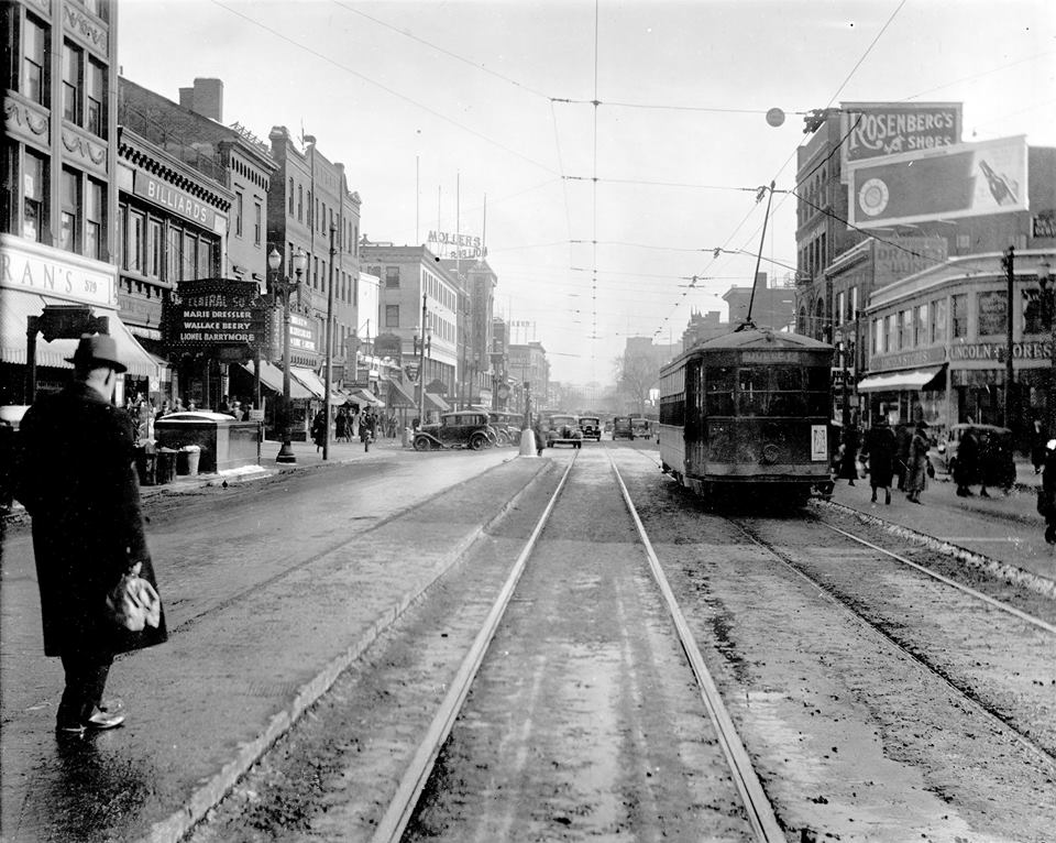
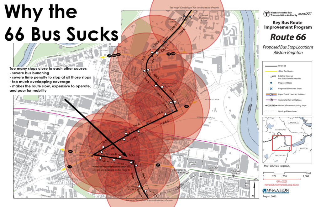
Of all the peculiarities in the MBTA’s Commuter Rail operation, one of the most apparent is the Providence Line. Where else can you find a modern, high-speed, electrified railroad with diesel-powered trains operating underneath the wire? Basically nowhere. Yet the MBTA incongruously runs diesels on the line, and not only that, it doesn’t spec its equipment for more than 80 mph, so the trains run at half of the top speed. The Providence Line is the system’s busiest, with upwards of 1000 passengers boarding daily at each station, but most board via the trains’ steps, lengthening dwell times considerably. It’s a 21st century railroad, but the MBTA runs it like the 19th. This provides far worse service than it should and costs the T—and the taxpayer—a lot of money while providing far less public benefit, in terms of regional connectivity and short travel times, as it could. Electrification would also allow for much more efficient utilization of equipment: with the same number of crews and cars on the line today, it would allow twice as many trains at rush hour.

Electrifying the Providence Line for the MBTA would not be trivial, but the costs would be relatively low given the existing infrastructure, and it provide benefits not just for Providence Line riders but for Amtrak riders and nearby residents. It would allow the diesel equipment on the Providence Line to move to other parts of the system, replacing the oldest equipment elsewhere. It would also be the first step towards building Regional Rail: a rail system which not only takes workers downtown at rush hour, but also provides mobility across the region. And where better to start than between the capital cities of Massachusetts and Rhode Island?

This post will address several of the benefits of upgrading the Providence Line to accommodate fast, electric rolling stock, and how they will allow the MBTA and RIDOT (which subsidizes the portion of the line serving Rhode Island) to increase service, decrease operating costs, and provide a better, more competitive product on the rails. With the MBTA’s fleet aging, it’s high time to examine the future needs of the network, and to begin the move to electric operation and a Regional Rail system.

Electric trains are cheaper to buy

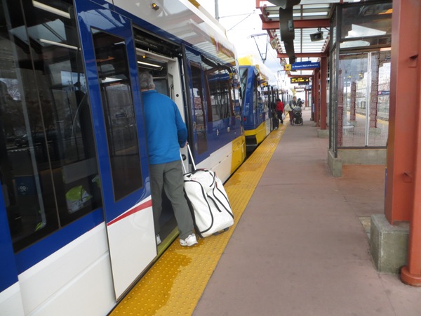
The MBTA’s most recent locomotive procurement had a unit cost of $6 million. The unit cost for the M8s delivered to MetroNorth has been in the range of $2.25 to $2.5 million, about the same as an MBTA Rotem bilevel coach. While the bilevel coaches do have more capacity than the single-level cars, a locomotive and six bilevels has the same capacity and costs the same amount as a train of eight EMUs. (Bilevel EMUs are also an option, although Northeast Corridor-spec’ed bilevel equipment does not yet exist, New Jersey may order some soon. If so, costs may not be appreciably be higher. Single level equipment with a proven track record could be bought off the shelf.)

Edit Dec 2018: The FRA has finally updated rules which would allow the T to buy European-spec equipment, like Stadler FLIRTs, which are significantly lighter than an M8 and have better acceleration. Here’s a video of a FLIRT accelerating to 100 mph in 72 seconds.

An electric locomotive pulling bilevel coaches would not have the acceleration benefits afforded by EMUs, but it would still be faster, and the cost of an electric locomotive is about the same as a diesel. Both electric locomotives and EMUs have a proven track record, running daily around the world, including on much of the Northeast Corridor.

In the relatively near-term, the T needs to buy new rolling stock. The T’s entire single-level fleet dates to before 1990; 55 of the cars were built in the ’70s; once the Red Line cars are replaced, they will be the oldest in the system (except, of course, the Mattapan Line). About half of the T’s locomotives date to the same time period, with 20 of them dating to 1973. It is no wonder that the agency is constantly short on both cars and motive power.

The T has had little luck buying new diesel equipment: the 40 new locomotives in the fleet are back and forth to the shops on warranty repair, and coaches aren’t much better: the Rotem bilevel cars are plagued with problems. So instead of doubling down on diesels that don’t work, the T could buy something that does: electric power. Replacing the Providence Line would free up a dozen-or-so train sets, which could be spread across the rest of the system to replace aging diesel equipment there. Thus, the up-front marginal cost of buying new trains would be effectively zero: the T needs to buy new Commuter Rail equipment anyway.

Electric trains are more reliable

Buying electric trains means buying a superior product. While they aren’t perfect, electrics have a much better track record of not breaking down. There’s no perfect metric for this, as I’ve mentioned before, since it is based on agency policy, but the numbers are so staggering they’re almost hard to believe. The T itself reports that its trains break down approximately every 6,000 miles. Meanwhile, the mostly-electrified Long Island and Metro-North railroads see approximately 200,000 miles between major mechanical failures. (A completely different calculation from Chicago shows similar results: the T is way below its peers.) A more apples-to-apples comparison can be made between different equipment types on the LIRR, where the new electric power breaks down ten times less frequently than diesels. While I’d take some of these numbers with a grain of salt, it’s clear that electric-powered railroads are more reliable than diesels.

Another of the costs of running Commuter Rail trains is fueling. Not only does it require staff and fuel, but the trains have to be moved to a fueling location in the middle of the day, which requires additional personnel and operating time and cost. Electric trains carry no fuel, and don’t have to make frequent trips to a fueling facility. They also don’t have to be plugged in or idled at the end of the day: the power to keep them on and get them started is always flowing above the track.

Electric trains are cheaper to run

In addition to the cost of electricity being less volatile than diesel, electric trains are simply cheaper to operate. This is somewhat less the case in the US, where every multiple unit is treated like a locomotive and subject to more stringent maintenance, but the costs are comparable, if not lower. This is especially the case for shorter train sets; if some trains on the Providence and Stoughton Lines used fewer cars, the costs would be significantly less. A locomotive-hauled train uses basically the same amount of power whether it’s pulling four cars or ten. A set of EMUs could easily be broken in half for midday service, reducing operating costs. A study of electrification in Ontario shows annual operation and maintenance savings of 25% (the full study, here, is worth a read). And this assumes low diesel prices. If the cost of oil spikes, electrics pay further dividends.

Electric trains and level-boarding platforms mean faster trips

The fastest trip time for MBTA equipment between Providence and Boston is currently 1:00 (for a 5:30 a.m. outbound trip) with some trips taking as long as 1:14. Amtrak’s Acela Regional trains make the trip in 38 minutes (the Acela Express trains make it in 33). Each stop adds about one minute and 45 seconds to the trip, so additional stops at Sharon, Mansfield and the Attleboros would add 7 minutes, for a total of approximately 45 minutes, end-to-end (Alon levy calculates similar numbers). A commuter from Providence would save half an hour every day; from closer-in stations, round trips would be 20 to 25 minutes faster.

High level platforms are just as important (see this post from California for a very similar issue). Today, Commuter Rail trains will spend two or three minutes of time stopped at major stations while hundreds of people climb the steep, narrow steps onto the cars. High level platforms—like those at Route 128, Ruggles, Back Bay and South Station—allow much faster boarding, increasing the average speed and decreasing the amount of crew time necessary to operate a train. They should be added to all stations, but the busy Providence Line stations are a good place to start.

Faster schedules mean more trains

The total amount of rolling stock required for a railroad is based on the peak requirement for rush hour. Currently, most equipment on the Providence Line runs one rush hour trip in the morning, and one rush hour trip in the evening, with some service midday. For some larger train sets, however, these are the only two trips which are run during the day: a large capital expenditure which is only used 10 hours per week. The first train leaving Providence 5:00 a.m. can make it back to Providence in order to run a second trip that gets to Boston around 9:00 (likewise, a 4:00 p.m. departure can be back to South Station by 6:30, after the tail end of the peak of rush hour) but everything else can only run once inbound in the morning and once outbound in the evening. This approximately 2:40 time (based on stopping patterns and layover) is called the “cycle time” of the line, and the amount of equipment needed to run service is based on this.

Now, imagine that you drop that 2:40 cycle time to 2:00 (45 minutes of running time and 15 minutes to turn at each terminal). That 5:00 a.m. train can run a second trip in to Boston at 7:00. (and maybe even a third at 9:00!). This is much more efficient: each train set can provide twice as much service.

To run service every 30 minutes, you only need four trains. Or, with the eight trains currently needed to run rush hour service from Providence, you could run trains twice as often: every 15 minutes. So instead of the current eight departures from Providence (and one short-turn from Attleboro) between 5:00 and 9:00 a.m.—with as much as 50 minutes between trains—you could instead have 16 departures from Providence: one every 15 minutes. This gives you double the capacity (and if trains are 15 minutes faster than today, you may well need it) and walk up service between the two largest cities in the region.

Off-peak, instead of running a train every one to two hours (or longer: there are service gaps of 2:20 in the current schedule), you could have a train every 30 minutes, again, with the same number of trains. (For the Stoughton branch, a short train could shuttle back and forth between Canton Junction and Stoughton during off-peak hours, meeting the mainline trains at Canton.) This is the promise of Regional Rail: fast, frequent, predictable and reliable trains throughout the day. Electrification and high level platforms would allow the T to operate this level of service with no more operating cost than today.

What’s more, much-improved weekend service on the line would also be possible. Today, there are trains only every two or three hours, and on Sundays, basically no service before noon. (This dates back to the days when the New Haven Railroad operated the service and didn’t provide service before noon, ostensibly because the parochial New Haven thought its customers should be in church, not riding the trains.) Hourly weekend service would be possible with just two train sets.

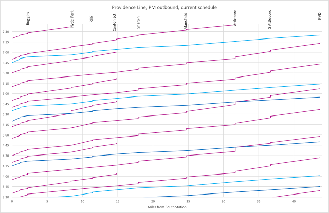
To visualize this, we can use what’s called a “string diagram” of the current MBTA and Amtrak service during the evening rush hour. The morning rush hour is less complex as there are fewer Amtrak trains in the mix since, except for one overnight train, the first Amtrak arrival from New York doesn’t arrive until close to 9 a.m. Each line shows a train running along the line; steeper lines show slower service. Purple lines show Commuter Rail trains, Light blue lines Amtrak regional service, and dark blue lines Acela Express service.

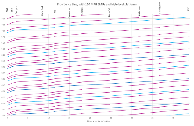
And here’s the same diagram, but showing every-15-minute EMU Commuter Rail service:

Notice how in the first diagram, purple and blue lines cross (this causes longer trips for Commuter Trains if they’re on time, and delays for Amtrak if they’re not) and how sparse the schedule is, that from 4:55 to 5:40, there are no Commuter Rail departures to Providence to let Amtrak run two trains out in quick succession. Note that in the second chart the slopes of the lines are much more similar, allowing trains to operate in closer proximity.


Electric Commuter Rail improves Amtrak service

With straight track, Massachusetts has some of the fastest track that Amtrak operates. Between Back Bay and Providence, Amtrak tops out at 150 mph, with 36 straight miles where the speed limit is 110 or higher. Acela Express trains attain an average speed—start to stop—of 102 mph between Route 128 and Providence. Yet across this line, the MBTA operates at at top speed of just 79 mph; with slow diesel acceleration (since the power plant on board a diesel electric locomotive is significantly less powerful than what can be pulled off the grid and put in an overhead wire) and boarding, peak trains make the trip averaging just 42 mph. In fact, going up the hill from Sharon, a fully-loaded eight-car set commuter set being pulled by a 4600-hp diesel doesn’t even have enough power to accelerate to 79 mph before it has to slow down for Mansfield. (Electric trains hauled by a 6700-8600 hp motor or EMUs with 1000 hp per car do not have this issue.)
This creates a scheduling nightmare. An Amtrak train needs miles of clear track between Route 128 and Providence to proceed safely, but the line is occupied by slow-moving commuter trains at rush hour. This leads both to long gaps in Commuter Rail service (for instance, there’s no train leaving South Station between 4:55 and 5:40) and cases where commuter trains sit on the side track at Attleboro for several minutes to clear the line so Amtrak can pass (this happens at both 4:45 and 5:45 during the evening commute), which can be seen on the first string diagram above.

Improving speeds with electrification and high-level platforms would solve these problems. Regional Rail speeds between 128 and Providence would increase to an average of 66 mph (including stops), causing significantly less interference in the schedule. By varying the departure times of some trains (having them leave three minutes before the clock-face schedule would require) they would arrive at Providence—which has four tracks and platforms, so an Amtrak train can easily pass—four minutes before the express Amtrak train. And if a local train is running late, it can still use the passing tracks at Attleboro to let an Amtrak train pass.

The T has some leverage to negotiate with Amtrak

Unlike most of the Northeast Corridor, the MBTA owns the track on which it, and Amtrak, operate. The T bought the right-of-way from the bankrupt Penn Central in 1973, and since then has cooperated to allow Amtrak to use the line in what is known as the Attleboro Line Agreement. Amtrak, in return for maintaining the line and dispatching trains, has used the line for free since then. A recent change in federal policy led to dueling lawsuits between Amtrak and the MBTA (where Amtrak was demanding the MBTA pay Amtrak for the use of its own line) and the they agreed on a smaller, but still significant, amount the T would pay Amtrak, even though the MBTA owns the railroad.

This means that if the MBTA were to increase service, it would have some leverage with Amtrak: it’s not a tenant railroad the way New Jersey Transit, SEPTA and MARC are. The T could demand that some of the funds it pays to Amtrak are directed towards improvements to the line in Massachusetts. It is in Amtrak’s interest, because dispatching high-speed trains would be much simpler if the rest of the trains on the line were fast, too, and that can only happen with better infrastructure.

Rhode Island benefits, too

In addition to the Attleboro Agreement, the Pilgrim Partnership has, for three decades, provided MBTA service—as subpar as it is—between Providence and Boston. In recent years, RIDOT has overseen the extension of the line to TF Green Airport and Wickford Junction, but with minimal ridership. One issue is the speed of the line: it takes 32 to 40 minutes for trains to make the 19 mile trip from Providence to Wickford Junction, even as Amtrak trains make it 45 miles across the Connecticut state line in that same amount of time. RIDOT has commissioned a study for in-state rail service, which looks at several options, including using EMUs.

The service, as currently operated, does not make sense. The demand profiles between Providence and Boston are very different than they are south of Providence. It would make sense to split the Boston-to-New York corridor in to three segments: Boston to Providence, Providence to New Haven, and New Haven to New York. On either end, passenger demand requires frequent, high-capacity train service. In between—from Providence to New Haven—shorter trains can be operated more frequently than Amtrak’s current schedule (some towns see only two or three trains each day). Amtrak’s bread and butter is intercity service: it should stop at Boston, 128, Providence, New Haven, Stamford and New York. One of RIDOT’s alternatives does just this, combining Rhode Island local service and Shore Line East. This makes sense. Coordinated service between smaller cities should feed into this higher-speed system, saving time for the majority of riders between Boston and New York while providing more-frequent, and only slightly-slower, service to the smaller towns in between.

How to upgrade the Providence Line

To build Regional Rail between Boston and Providence, here’s what you’d need to do:

  1. Upgrade the electrical systems to allow more power to be distributed across the line. Luckily, someone had their head screwed on straight when it was built and it was designed to have additional power dropped in to place. The T could negotiate with Amtrak to use its $20 million annual “blood money” for this.
  2. Extend power over any unpowered tracks on the NEC and on the Stoughton branch. This amounts to only a few miles and Stoughton is short enough that it shouldn’t need significant distribution infrastructure. Wires are cheap. Substations, which wouldn’t be necessary, cost.
  3. Build high-level platforms at Hyde Park, Sharon, Mansfield, Attleboro and South Attleboro stations. This will allow the purchase of rail cars without any “traps” or steps, and will allow much faster boarding and alighting via all doors on a train. It would also make these stations—each of which serves more than 1000 commuters per day—fully ADA compliant.
  4. Requisition and procure approximately 120 EMU rail cars for operation on the Providence and Stoughton lines, in four-car train sets (or perhaps pairs to allow two-car trains south of Providence and at off-peak times). Peak service from Providence and Stoughton to Boston would require 11 train sets (88 cars), Rhode Island two four-car trains (8 cars), with the required number of spares. The Federal Railroad Administration may allow lighter, faster European-style EMUs to operate on lines like this (update, it has, see above), which would further reduce the cost.
  5. Build a light-maintenance facility at or near the Pawtucket layover facility, the former Attleboro layover or perhaps in Readville. If built in Rhode Island, the Ocean State could foot these costs in return for maintenance jobs in state. Light maintenance could be conducted locally, with Metro-North contracted for major running repairs at its New Haven facility, at least in the short term. The trip from Providence to New Haven wouldn’t take much longer than the current trip from South Station to Boston Engine Terminal via the Grand Junction, and cars could even be sent attached to Amtrak’s overnight trains or in service in the Rhode Island-Shore Line East scenario.
  6. Move current rolling stock used for Providence and Stoughton to other MBTA lines, retiring the oldest and least-reliable equipment, and mitigating the car shortage on many lines. Rather than buying balky diesel equipment, procure off-the-shelf designs proven to work in other markets, and put them to work here.
One caveat would be capacity constraints at South Station (although the Providence Line, with 15 minute turns at rush hour, would only require two tracks, with an additional track for Stoughton) and slots on the Northeast Corridor to where the tracks split at Readville. Some trains could be slotted ahead of Amtrak service (where there are 10+ minute schedule gaps, more than enough time for a train to get to Forest Hills or Readville and then clear the line). Franklin Line trains in the non-peak direction could be routed along the Fairmount Line at rush hour to free up slots as well. The Stoughton Line could be run as a shuttle from Canton Junction, which would eliminate a one-seat ride for Stoughton passengers, but provide much more frequent service than the once-an-hour service to Stoughton. In the long run, a North-South Rail Link would obviate the need for South Station expansion.
For too long, Commuter Rail has been the ugly stepchild of transit in Massachusetts. Even as the region hosts the fastest trains in the Western Hemisphere, the MBTA operates far slower than it could. Other than “we’ve always done it that way,” there’s no reason for this. This is a small investment which would would pay for itself in increased ridership, lower operation costs, more efficient fleet use and the economic development from closing the distance between Boston and Providence (which itself is hardly a backwater). This would also bring lower-cost housing along the corridor within easy commuting distance of Boston, and bring two of the largest cities in the region closer together. It needs leadership and forward-thinking people at the T and RIDOT to step slightly outside their comfort zones. But it is certainly not impossible.

How many people use Commuter Rail? More than you might think.

In case of confusion: this is what
I am calculating here.

There seem to be misperceptions as to how many people Commuter Rail carries in Boston. So I decided to calculate how much of the capacity train lines carry compared to the total number of people traveling in the corridor (by rail and highway), to get a sense of how important the rail lines is to the overall transportation network. 33% would mean twice as many drivers as rail passengers, 50% would mean the same amount on the road versus the train. To put it another way: if everyone on the train drove, would traffic get a little worse (15%), or a whole lot worse (50%)? To put it another: if the trains were faster, more frequent and more time-competitive with driving, how much of a dent would it put in traffic, or, at least, how much increased capacity could it account for?

How did I do this? I took the CTPS train count data and calculated, for each line, the number of passengers arriving during the single peak hour of service (generally 7:30 to 8:30). For each highway or major road leading in to the city, I looked at MassDOT traffic data and calculated the number of cars coming in to the city for the same peak hour. The I grouped these together in to corridors and compared the results. (It turns out that Alon took a quite different methodology, and came up with similar results.)

What are the results? Well, before I took the results, I took a poll on Twitter to see what people think the results would be. The poll is kind of braindead and only allowed for four options, so I put in a range from 10 to 70% in increments of 15% (the answer falls somewhere in this range). If you haven’t seen this poll already, go ahead and vote: [note 1]

The correct answer? From my data, and supported by Alon’s, it’s about 42%. [note 2] So about 80% of people are underestimating it. I can see how this happens. Good infrastructure looks empty. The Providence Line north of Hyde Park may only have a train every nine minutes, yet it carries more people than a jam-packed, four-lane highway. [note 3] If you sit on the Turnpike in traffic for half an hour you may only see one train roll by (never mind the fact that train is carrying several miles worth of traffic [note 4]).

Now, 42% is low. Mode share is much higher in New York and Chicago. [note 5] This means that Boston’s lines have room to grow with better investment, which is why we need a long-term vision for the rail network and need to make sure that projects like Auburndale don’t go awry and permanently crimp capacity.

Corridor Road Rail Highways CR Lines
Northeast 5956 2936 1,
1A
Newburyport,
Rockport
North 4647 3937 93 Haverhill,
Lowell
Northwest 3966 1792 2 Fitchburg
West 8385 6646 90,
9, VFW
Worcester,
Needham, Franklin
South 12025 8498 95,
28, 138, 3A, Granite Ave
Providence/
Stoughton, Old Colony

Or, graphically:

So, why does this matter?
First, it shows that Commuter Rail passengers account for nearly half of the commuters in some sectors, especially since these data don’t account that many of the drivers on these highways aren’t headed downtown but nearly all Commuter Rail riders are. (For instance, some drivers on I-93 in Quincy are probably headed to Peabody or Woburn, but few if any Commuter Rail riders are, at least until we build the North-South Rail Link.) Second, it shows that the Commuter Rail system is under-appreciated: 80% of respondents undervalue its need.
Most of all? The Commuter Rail system has room to grow. Highways most certainly do not. Here’s what the throughput on I-93 looks like at rush hour (data from a week in May in 2016):

Note the dip after 7 a.m. As traffic increases and speeds decrease, both in this segment and downstream, congestion actually decreases the throughput of the roadway. There’s no more room to put cars. And this occurs on most major highways in the region. If we were to drop Commuter Rail passengers on to the highways, it would be cataclysmic. Maybe in 1969—when highway volumes were a third of what they are today—Commuter Rail seemed like an antiquated concept. Even with the old, tired infrastructure the MBTA operates, that’s not the case today.

We’re not about to build wider highways (it’s expensive and doesn’t work anyway). But the region is growing: for the first time in a century the population of the Boston area is increasing at a rate faster than the country as a whole:

This chart is actually quite amazing. (no data before 1860 for the Boston MSA)

The highways are full. The subway is close. The railroads have capacity, and they link downtown to many regional centers with more available housing. They’re over-utilized compared with our perceptions but under-utilized compared with their potential, and other Commuter Rail lines in other cities. From the lows of the 1970s, the lines were upgraded in the 1980s, and ridership responded. Since then both planning and ridership have stagnated. As the region grows we need a better plan for our rail assets now, and for the future.

Note: 


General note on data: This is counting only people on highways and other major roads and Commuter Rail. Think of it as anyone coming from outside 128 (or outside the reach of the Rapid Transit system) to the Downtown area. There are certainly some people who take back roads that whole way, but they are probably a relatively small number in comparison. There are about 412,000 jobs based in Downtown Boston plus Seaport, Back Bay and Fenway, and maybe another 50,000 in Cambridge. This is only during peak hour; off-peak travel—when train schedules are limited and roads clearer—are likely much more car-dependent.

Note 1: As of the posting of this blog, the votes broke down as follows and have been stable in this range for several hours:


Note 2: This is a coarse, broad measurement. For certain towns with relatively good rail service and poor road connections—Attleboro/Mansfield/Sharon, Acton and Salem come to mind—the Commuter Rail mode share is likely much higher. 


Note 3: Of course, the Metro-North Park Avenue viaduct carries 47 inbound trains between 7:30 and 8:30 a.m., probably carrying upwards of 40,000 passengers. You’d need half a dozen eight-lane highways to carry that many people. Some New York subway lines carry nearly double that, but over shorter distances.


Note 4: The heaviest train on the Worcester Line, train P508, carried 1179 passengers in 2012; reports are that it’s closer to 1500 today. A dense traffic jam may have one car every 30 feet, or 176 cars per lane per mile, or 528 cars on a three-lane highway, so two miles of traffic wouldn’t even cover all of P508. A well-patronized train, in other words, carries about as many people than a traffic jam from Newton Corner to Auburndale. Highway capacity is quite finite.


Note 5: In Chicago, for example—perhaps a better comparison since parking is cheaper than in Boston and freeways provide better downtown access than New York—Metra’s BNSF line carries 60,000 passengers per day. At rush hour, there are 15 trains carrying upwards of 11,000 passengers per hour, more than the parallel Eisenhower and Stevenson freeways combined (and another 6000 ride the UP-W line in the same catchment area). Metra’s busiest station, the gargantuan Route 59 park-and-ride, generates as many as 1000 people per train, and there’s a train every 20 minutes at peak rush express to and from the city. Note that unlike the MBTA, the park-and-ride is in addition to, not instead of, downtown stations in nearby Naperville and Aurora.

Auburndale is broken. Here’s a way to fix it.

Recently the author of this page attended a public meeting about the Auburndale Commuter Rail station and found the process completely broken. Local advocates and lawmakers had obtained earmarked funds to build an accessible station—a necessary and laudable project—and gone to the MBTA for a design. The MBTA—mostly through the sheer incompetence of its project management team—had returned with an overpriced design which is likely unusable and should not see the light of day.

The design could have the effect of creating a single-track railroad at rush hour at Auburndale in order to maintain peak-hour service to and from Boston (see Dave’s blog post for more). This may not even be possible, since before 9 a.m. there are 19 trains passing through Auburndale in both directions, and two tracks are needed. There was no evidence presented at the meeting that MBTA Railroad Operations has modeled the operations, and it’s quite possible that if the current design is built, it will result in the elimination of peak-hour service to and from Boston at the Auburndale station (in order to avoid the “single track” operation). If this happens, the Federal Transit Authority could (and may likely, see Cleveland) demand to be repaid for the federal portion of the money since the FTA (rightly) does not like to be in the business of reducing transit service.

The long and short of this discussion is that, as currently designed, it would be a mistake to build the station. At best, it will be a monumental misappropriation of several million dollars, and a shining example of government waste and incompetence. At worst, it will result in reduced transit options for hundreds of commuters—or potentially degrade service for the 16,000 daily riders on the Worcester Line—and the real potential that the FTA would force the MBTA to pay back funds for the project, costing the state even more.

There is, however, a logical way to fix it. In my last post I posited that, for the same price as the Auburndale Station, high-level platforms could be built at all three Newton Stations. This, however, still creates operational issues with trains crossing over between tracks at rush hour, and also sets a poor precedent: no two-track railroad should have a platform built only on one side.

Before the Turnpike, there was a crossing under the railroad
between Auburn Street and Woodland Road.

So in this post, I’ll explore how, instead of building a single platform and a crossover for $11.5 million, you could easily build a full, two-platform station for the same price. In addition, I believe that there is the potential to significantly improve accessibility and connectivity in Auburndale for mobility-impaired users as well as pedestrians and students. By leveraging the construction of the station, Auburndale can build a more cohesive walking network between the two sides of the village. (There’s some precedent for this: the original pre-Turnpike station had an underpass near Melrose Street.)

Let’s remember the numbers. The total cost of the project is $11.5 million, in the same ballpark as South Acton ($9.5 million) and Yawkey ($13.5 million), both of which are recently constructed two-platform stations with an overpass. According to the current Auburndale plan, the cost of the high level platform is $1.7m, the station canopy $810k, station systems $180k, site work $436k and parking modifications $1.6m. The rest—$6.7m—is for the new interlocking that a two-track station would not need. My proposal is as follows (a diagram is included further down this post):

  • Platforms would be built adjacent to both tracks. The track 1 (north side, adjacent to Auburn Street) platform would be built generally as currently designed. The track 2 platform (south side, adjacent to the Turnpike) would be built along the eastern portion of the current station and under Auburn Street. This allows the platform on this side of the tracks to avoid having a platform on the inside of a curve. High level platforms on the inside of a curve require a larger gap between the platform and the door of the train: a more dangerous “mind the gap” distance. The main station canopy would be shifted to track 2 where the bulk of boardings and alightings (inbound during the morning peak, outbound during the evening peak) occur. [See Note 1]
  • Access to track 1 would be much as currently designed, with a ramp accessing the platform from the parking area and another, shorter ramp (and stairs) providing access from near Melrose Street. Access to track 2 would be via a new pedestrian overpass built near Melrose Street. Access to the overpass would use a ramp from near the parking lot (which is already located about 10 feet above the railroad, mitigating the need for a particularly lengthy ramp) and from a set of stairs near Melrose Street. It is important to note that a new overpass over the railroad is required, rather than an accessible ramp or access to the track 2 side from the existing Auburn Street bridge. The Auburn Street bridge is too steep to meet design guidelines for access. [See Note 2]
  • On the track 2 side of the new pedestrian overpass, a stairway and elevators would provide vertical circulation from the overpass to the platform. This would be a bit of a mirror image of the setup at Yawkey Station, except the overpass would span both tracks. Neither track would need to be moved during construction. A separate stairway would provide secondary access and egress at Auburn Street (similar to the existing stairway there).
  • The new pedestrian overpass over the railroad tracks would align with Hancock Street on the south side of the Turnpike, both vertically and horizontally. This would allow a pedestrian bridge to be easily installed across the Turnpike between Hancock Street and the rail overpass. Most of the cost of such bridges is the cost of ramps, landings and abutments (the actual steel for the pedestrian bridge is relatively cheap, although a more attractive bridge—which might pay homage to the original HH Richardson design—may increase costs). By taking advantage of the elevation of Hancock Street and the need for an overpass to cross over the railroad for the station, these elements would be almost entirely in place. This would also obviate the need to build a walkway to Woodland Road as passengers desiring to access the station from Woodland Road could walk along Central Street or Auburn Street to access the station.

It’s this last point which, I think, really makes the case for this plan for Auburndale Station because it not only improves conditions for the several hundred passengers who use Auburndale every day, but also provides better conditions for the rest of the neighborhood. It would provide:

  • An accessible pedestrian crossing between the business district to the north and the neighborhood to the south, something which none of the 1960s-era automobile-centric bridges provide.
  • Better access for many commuters since most anyone living south of the Turnpike would have a shorter walk to the station. [Note 3]
  • Much better and safer access to the Williams School from Auburndale Square; anywhere north of Commonwealth Avenue is in the Williams district. Students who currently walk along Auburn and Grove Streets or Auburn Street and Woodland Road—busier roads with dangerous intersections—would instead be able to cross over the Turnpike and walk up the much-quieter Hancock Street to access the school.
  • A more-connected neighborhood. Today, the distance between each crossing of the Turnpike in Auburndale is about 1500 feet. [Note 4] This is not a problem if you’re in a car, but makes the neighborhood much less walkable. Adding a pedestrian connection would better connect the neighborhood’s business district to nearby residences.

The marginal cost of this bridge would likely be about $300,000 (since most of it would be necessary for the construction of the station), or 3% of the total cost of the project, yet would have dramatic benefits beyond the Commuter Rail station.

The rest of the station could probably be built for the same cost as the now unneeded interlocking in the original/current design. Let’s first assume that the need for a separate stand-alone canopy for track 1 would be obviated since the station would be partially covered by the overpass (and most passengers would board on track 2). Let’s next assume that a platform on the south side costs the same as one on the north side: $3.2 million including a platform, canopy, station systems and site work. This leaves $4.3 million for the overpass, ramps and elevators (I am basing these estimates partially on the cost estimates for the Winchester Station project):

  • Ramps should cost about what an overpass costs, since a ramp is basically an inclined overpass. There new ramp would need to gain approximately 10 feet and would probably cost about $300k. (This seems to be in line with the costs of the much-more-extensive ramps at Winchester, which rise about 24 feet and cost about double.)
  • Each stairwell probably costs about two-thirds of a ramp (since stairwells are shorter and thus require less roofing and can be easily pre-fabricated). There are three stairways, one at Auburn Street and one on each side of the overpass: $600k, although it’s possible the Auburn Street stairs could be reused.
  • The overpass over the railroad would likely cost double the cost of the overpass over the highway, or approximately $500,000.
  • Elevators are expensive, and you need two of them for redundancy. They cost about $1m each (which is why, if you can get away with not-very-long ramps on the north side, it makes both financial sense and accessibility sense to design a solution which doesn’t require an elevator).
  • To allow wide freight passage, it might be necessary to install a “gauntlet track” to allow freight to move away from the platform. The cost for this in Winchester is $825k. (Considering how infrequently this would be used—a few times per year, at most—it could be built, like Winchester, with hand-thrown switches, and, when in use and if necessary, could block both tracks without major detriments to the schedule outside of rush hour.)

So the total cost of these elements would be just about $4.2m, leaving $100k for an overpass to Hancock Street (I swear I didn’t add these numbers up to try to equal that number, it just happens that that is the case). There’d likely be some contingency, but several MBTA Commuter Rail bids have come in below estimates (Blue Hill Ave, for example), so it’s possible it could actually cost less. In any case, the extra $200,000 for, say, a bridge to Hancock Street could be funded by the City, or perhaps even a Safe Routes to School-type grant.

Here’s the drawing of how this could be implemented:

It is imperative that we get Auburndale Station “right.” In its current configuration, the station woefully underserves the village and the surrounding neighborhood. The new station, as currently proposed, may be worse. We need Auburndale Station to be built with the operation—current and future—of the whole line in mind. If Auburndale Station can be built to provide better connectivity to the neighborhood, that’s a large bonus. And if the station here can be upgraded within this budget, it will set a blueprint towards the eventual similar upgrades of West Newton and Newtonville, both of which have the same similar accessibility problems as Auburndale. As such, they need to be future-proofed.


Notes:


Note 1: The Worcester Line is left-running in the evening both to serve the one-platform Newtons as well as stations in Wellesley and Natick where it helps minimize the number of passengers who have to cross the tracks. Dave has an excellent blog post detailing this here.

Note 2: The bridges were designed in the early 1960s, well before the Americans with Disabilities Act was passed. The grade issues are both the overall grade as well as the cross-slope of the corners. If this is confusing, just imagine getting up from Auburndale Square to the top of the Auburn Street bridge in a wheelchair.

Note 3: 

At the most extreme, it would shorten the walk to the station for someone living on Hancock Street by a quarter mile, although may residents who live south of the tracks would have a shorter walk to the station and Auburndale Square in general.

Note 4: This is significantly longer than similar distances between bridges in West Newton and Newtonville.

Good intentions, bad plans, and $7 million wasted

The Auburndale Station is a mess. It is planned for a rebuild, which it sorely needs. But thanks to the MBTA’s planning process (which ignored little things like rail operations), that’s a bloated mess. There have been two public meetings four years apart, and during that time a plan has been put forward which bakes in bad design and pays no mind to any larger-scale issues on the Worcester Line. It’s the T’s planning process at its worst, which is saying something.

The villages of Newton developed in the mid-1800s along railroad lines; the concept of the commuter—the term, indeed!—began with the Boston and Albany’s “commuted” season fares in the early 1840s. If anyone can lay claim to commuters, it’s Newton, even if they now enjoy some of the worst Commuter Rail service in the region. In the 1960s, when the Turnpike was planned, Newton fought a losing battle against it (way too much background here). The old stations were replaced with rickety stairs and narrow platforms, and by the early 1970s, there was minimal train service on the line. Since then, however, the number of passengers on the Worcester Line has grown many-fold (from 600 in 1972 to 16,000 today), yet the line infrastructure generally still dates to the 1960s. With dozens of steps to the platform, these rail stations were inaccessible for anyone with mobility needs, and inhospitable to others. And the single platforms were only accessible by these stairs from a bridge, cut off from the portions of the village centers not cut off by the Turnpike.

Several years ago, the local state representative, Kay Khan, worked with then-Congressman Barney Frank to earmark federal money to build an accessible station at Auburndale. While this goal is laudable and the need is clear,  due to a combination of and overall lack of vision for the line and possibly some incompetence, the team retained by the MBTA specified a project which provides few benefits with a high cost. The Worcester Line should not be fixed piecemeal, but needs an overarching vision, which is currently lacking. Still, this should not be an excuse for the lack of understanding which has led to the current state of this project.

The Newton stations are the only ones on the Worcester Line—and on pretty much any Commuter Rail line in Boston—with single platform on one side of double tracks (on the south side, which is Track 2). As such, the stations have no reverse-peak service: there’s enough traffic on the line that trains can’t run in and out on the same track at rush hour, so, for instance, there’s no inbound train leaving Auburndale between 1:12 and 7:31 in the afternoon. The obvious—and best—solution would be to build a new facility with platforms on both sides of the tracks, although such projects—like the recent station in South Acton—cost about $10 million each.

Building a single platform in situ on the south side would not be much cheaper, since it would still require ADA accessibility which, in the case of Auburndale, would require an overpass and redundant vertical circulation, and elevators cost about $1 million each. The actual platform only costs about $2 million, but getting there costs significantly more. It may be possible to build elevators from the current bridges, but the current sidewalks leading to the bridges are too steep to meet ADA requirements, so additional bridge work would be required. In any case, it makes sense to build a platform on both sides. (There’s also the question of building a gauntlet track to allow infrequent wide freight trains to bypass the platform.)

A somewhat cheaper option in Auburndale is to build a single platform on the north side of the railroad (adjacent to Track 1); this is what is proposed. This would be significantly less expensive because it is adjacent to the local street and requires minimal vertical circulation: just a couple of small ramps instead of elevators since the platform would lie only about three feet vertically below the sidewalk. It doesn’t solve the reverse-peak issue and still only provides one platform for service, but it at least puts that platform in a much more accessible location. If you only have money for one platform, this makes a lot of sense, with one major caveat: you have to rebuild West Newton and Newtonville on that side as well. If you don’t, it’s nearly impossible to serve platforms on Track 2 at Auburndale and Track 1 at the other Newtons, and even if you can, it requires an expensive interlocking and signal changes to do so. Without an interlocking, Auburndale would lose all peak commuter service, which is used by 325 passengers per day (the busiest of the Newton stations). With an interlocking, the cost of building the station triples.

So what did the MBTA do? They, of course, proposed to rebuild Auburndale on the north side, and to install an interlocking east of the station—just a mile east of the current CP 11 (see Weston Switch at Dave’s glossary)—to allow trains to move from one track to another. Setting aside the operational difficulties of having two interlockings a mile apart and switching trains frequently back and forth, the interlocking—and associated signal changes—costs a lot of money. Here’s the cost breakdown they presented:

Site
Work
436,138
High Platform 1,733,094
Station
Canopies
$810,000
Parking Lot
Modifications
$1,685,750
Track and
Interlocking
$6,685,750
Station
Electrical
$179,156

Now, let’s break this down in to three parts. The station itself (site work, platform and canopies) costs $3.16 million. The parking lot modifications to create ADA accessible spaces costs another $1.69 million. This accounts for 42% of the total cost of the project. The rest, 58%, is for the interlocking and track and signal work associated with it. This work is entirely unnecessary. First of all, there is already a perfectly good (or at least good enough) interlocking one mile west, so this won’t have any operational efficiencies for the rest of the line (and will likely cause operational issues; the project team admitted that they have not modeled the schedule impact of this). Second, the line is likely to need new signals within the next decade, so this would likely be good money thrown after bad: the signals would have to be coordinated with that project, or replaced, and the interlocking is in a sub-optimal location so close to the current switch at CP 11.

Now remember: a north side station works if the other two Newton stations also had north side platforms. And the actual cost to build a platform here costs only $3 million (this is about the right ballpark: at stations like South Acton, for instance, each platform costs $3 million and the vertical circulation costs another $4 million). If you build all three stations, you save $6.7 million by not rebuilding the interlocking, and using CP 6 in Brighton and CP 11 in Weston to move trains back and forth as needed. You also have trains on a long-enough section of track that others can pass without encountering suboptimal signal aspects. (In other words: think of passing a tractor on a country road. If there’s a long straightaway with good sightlines, you can easily keep up your speed, change lanes, and make the pass. If there’s just a short section, you have to slow down, make sure there is enough room, the tractor may pull to the side of the road, and you pass at a lower speed. This is what a mile between interlockings would entail.)

$6.7 million should be enough to build a north-side platform at West Newton and Newtonville. Newtonville is easy: there’s actually an old, low-level platform on the north side which would provide a suitable base for a high level platform, which could be connected to the sidewalk by stairs and short ramps. There is 35 feet between the sidewalk and the edge of the track, plenty for a platform and vertical circulation. West Newton is a bit more difficult: it’s only about 700 feet between bridge abutments, and the T prefers to build high level platforms 800 feet long (although an eight-car train is only 680 feet long, and Yawkey Station is that length, with tapered platform ends to accommodate the site). In addition, some excavation would be required to remove the granite blocks on the north side (these were the original supports for Washington Street which, before the Turnpike was built, crossed diagonally) although these might provide a suitable base for a high level platform. But the parking lot already has accessible parking, and there is ample room to build ramps and a platform.

The issue is not that we don’t have the money, it’s that we’re going to spend it in about the most wasteful way possible. The question is how to—and whether we can—reallocate this money. The Auburndale Station has about $3 million of federal dollars earmarked for it, so that likely could not be reallocated. Much of the rest of the money is included in the state’s five-year Capital Investment Plan (CIP), a document released by the state. That money could, theoretically, be reallocated, although it would be a political process, and there is, apparently, no guarantee that the money would be reallocated to the other Newton stations (which are not in the current CIP). But here’s the rub. There are three ways you can spend $11 million on the Auburndale Station:

  1. Spend ~$4 million on the Auburndale Station, and $7 million on an interlocking which has not yet been modeled and may overall degrade service on the Worcester Line and no guarantee you could provide even the current level of service.
  2. Spend ~$4 million on the Auburndale Station, and the remaining $7 million on similar improvements to West Newton and Newtonville. This would actually improve service on the line (local trains serving high-level platforms would have shorter dwell times, improving accessibility, service speed and reliability) and you could certainly provide the current level of service.
  3. Spend $11 million on the Auburndale Station, but instead of building an interlocking, build platforms on both sides with ADA accessibility. 
The first is wasteful. Either of the other two is a good start towards better service and accessibility in Newton.

Making this cahnge would require the cooperation of MassDOT and the politicians in Newton and elsewhere. There would have to be promises made—perhaps even legislation passed—reallocating the $6.7 million from the interlocking specifically to the West Newton and Newtonville stations. If you build Auburndale and build the interlocking, you waste $6.7 million on the interlocking to build a $4 million station. But if you build Auburndale without the interlocking, you waste $4 million on a barely-usable station. Unless you build two platforms, Auburndale, West Newton and Newtonville are joined at the hip. You can spend $11 million and get an attractive, accessible station at Auburndale, or spend the same $11 million and get three stations for the price of one. 

This process should have never gotten to this point, of course. The project management team is mostly to blame: they ran amok with a design which has become far too expensive and provides little, if any, benefit. In addition, the fact that the MBTA lacks any long-term vision for Commuter Rail or the Worcester Line leads to these piecemeal, wasteful approaches like this. The corridor needs a long-term vision, which is something which should be in the wheelhouse of the Worcester Line Working Group.

Coming back to Auburndale, however, there are two preferable solutions: a two-platform station, or improvements to West Newton and Newtonville. The costs are about the same, and the benefits are much higher than an interlocking you don’t need. Mistakes were made. We can either double down on the mistakes—and waste $7 million taxpayer dollars—or we can make the best of the situation, spend the same amount of money, and come away with a lot more to show for it: either a two-platform Auburndale or accessible stations throughout Newton.

This has gone from being an engineering issue to a political one: and this is why we elect political officials.  As we say in Patriots Nation: Do Your Job.

The Track 61 High Speed Line (and new trains for Mattapan)

The Mattapan Line deserves new rolling stock, but buses make no sense. It’s not that the PCCs which run the line are unreliable—they’re plenty reliable—but parts are hard to come by (some are custom made by a museum in Maine) and the fleet is a throwback to the 1940s, making the 1969-era Red Line cars look young by comparison. New, modern streetcars could each carry nearly double what a PCC does with more low-floor doors for far more efficient boarding. By spreading weight across three trucks (sets of wheels) instead of two, the whole “the bridges won’t support larger vehicles” straw man. (PCC: 18,000-21,000 lbs/truck, plus air conditioning units, Seattle streetcar: 22,000 lbs/truck.) The bridges likely need some work anyway, and a concrete deck to support buses weighs a heck of a lot more than ballast and track (buses need a lot of concrete). And the T is good at quickly replacing old bridges. So maybe you just replace the bridges.

For example, the Seattle streetcars cost on the order of $3.2 million each, and Mattapan would likely need five streetcars, and two spares, to run service, so about $22 million overall. Streetcars are spec’ed to last 30-40 years, so it’s a $500,000 investment per year. 10 buses, at $750,000 per bus, would cost $7.5 million, but only last 12 years, so the capital cost would be about the same (30 buses over 36 years = $22.5 million, slightly less given a discount rate, but at least right now, money is cheap). And the cost to convert the corridor to bus transit—given BRT costs of $10-$50 million per mile—the cost of vehicles would be dwarfed by the cost of concrete. The answer for Mattapan is easy: just buy modern streetcars for the Mattapan High Speed Line.

But then what do you do with the PCCs? They’re still sort of useful transit vehicles, and it’s not hard to look at San Francisco to see where PCCs operate as both transit vehicles and as transit and as a rolling museum (and tourist attraction). We won’t run PCCs in mixed traffic on the Green Line any time soon (or probably ever), but there is somewhere that the fleet could provide a useful transit connection and operate in a tourist-friendly location: between Andrew Square and the Convention Center.
Why this route? While older streetcars could conceivably run on surface lines (and did as recently as the late 1990s) doing so with any regularity would have liability and accessibility concerns, and decrease the capacity of the Boylston-Tremont subway dramatically, where a slot using a 45-foot PCC is far less efficient than one with a two- or threee-car LRV. It would also require pantograph conversion. San Francisco gets around this by running the PCCs on the surface of Market Street with the light rail in the tunnel below (which was built in 1982, only 85 years after the Green Line went underground in Boston). Basically, in Boston, the current light-rail lines are out.
So that leaves a purpose-built line. Nearly every rail right-of-way in Boston is used for rail service, or has been converted to a multi-use pathway. (For instance, Minneapolis runs historic streetcars on an old section of streetcar right-of-way, but other than a short portion of the Fells, we don’t have that.) With narrow streets, we can’t easily throw in something Kenosha-style. But there is one stretch of railroad track in Boston which sits unused: the so-called Track 61 in South Boston.
The state currently owns Track 61, but it hasn’t been used for freight service in decades (and other than vague platitudes, there are no plans to do so any time soon.) There have been calls to run DMU service on Track 61, but this is such a risible plan—crossing the Northeast Corridor and Old Colony lines at-grade, at rush hour, in a roundabout route—that it will never happen, even if the T were to acquire the appropriate rolling stock. Recently the City of Boston has proposed using it for a split terminal from the Fairmount Line, which is more feasible, but still requires a diamond crossing of the Old Colony Line, and the desire line of the Fairmount Line almost certainly aims downtown (and where there is a Red Line transfer), not at the Seaport. If freight were ever to run across the line, streetcars would not preclude future freight use at off hours (which is done in several other corridors) if shipping traffic required a daily freight movement on the line.

The route of Track 61 and an extension to Andrew in yellow.

It’s the route of Track 61 which is most intriguing, as it would make a last-mile connection between the Red Line and the Seaport, which currently requires a ride on two over-capacity transit lines (the Red Line to South Station and the Silver Line to the Seaport). For commuters from the south going to the Seaport, a transfer at Andrew would save five minutes of commute time, and (more importantly) it would pull some demand off of the Silver Line at rush hour, when buses run every minute-or-so at crush capacity and leave passengers on the platform. With some minor (seven figure) improvements (stations, overhead, a couple of interlockings), there is an unused rail corridor with mostly-existing rail on which the PCCs (or new rolling stock) could be run in relatively short order.

The key would be to find both funding and possibly a non-MBTA operator. (Power could be acquired from the adjacent MBTA facilities, but it could be run by a different organization. Let’s start with funding: there are mechanisms in place. Capital costs could come from a TIGER-type grant, and operating costs from a transportation management association or perhaps from the Mass Convention Center Authority or even MassPort, especially since they have hundreds of millions of dollars for parking garages in the area (maybe, uh, we shouldn’t build that parking garage, wait, don’t call it that).

Amazing! Trams/streetcars can have level boarding.
(Minneapolis-Saint Paul “Metro”)

As for the rolling stock: The current PCCs are inaccessible, but are made accessible with high-platforms along the Fairmount Line. This could be replicated along Track 61, especially since the stations would be built from scratch and fewer in number. (In theory: Andrew, Broadway, Convention Center, Black Falcon.) More likely would be low-platform modern trams (and by modern, I mean “flush with the platform”) to run on the line with PCCs used for supplemental service (weekends, middays, etc). It might be possible to strike a deal with the Seashore Trolley Museum to both use the Seashore-owned 5734 (which likely needs some rehab but ran within the past 20 years and has been stored underground at Boylston) and perhaps relocating some other MBTA equipment from there for an outpost of the Maine facility: a small, San Francisco-style rolling museum showing the transit history of the oldest subway in the country.

DMUs and commuter rail to the Seaport is a round-peg-square-hole issue. The scale is not really appropriate (especially if it is diesel, with more local particulate emissions in a high-density residential community) and the routing certainly isn’t. (There’s also the matter of significant single-track, which is easier to navigate with light rail equipment.) Moreover, with the Red Line adjacent at one end and the Silver Line at the other, it might be possible to simply tie in traction power from each end without building any new facilities, so the power costs would be minimized (overhead is cheap, substations are expensive). Track 61 shouldn’t be let to sit and fester for the next 25 years. But if we do something with it, let’s do something sensible.

A single letter costs the T $2–3 million every year

Every night in Downtown Boston at about 12:45 a.m., a procedure, in theory, occurs to allow passengers to transfer between trains downtown and not miss the last train. (This dance is called “East-West”; the name probably goes back decades.) Here’s how it should work (note that this is from an operations standpoint; passengers transfer as they normally would):

  1. The final Green Line trains from Lechmere, Boston College, Cleveland Circle, Riverside and Heath Street arrive at Park Street. 
  2. The last southbound Orange Line train waits at State Street for the last inbound Blue Line train.
  3. Once it arrives, the Blue Line train continues to Bowdoin, loops, and waits at Government Center. The Orange Line train proceeds south to Downtown Crossing.
  4. The last Alewife Red Line train leaves Downtown Crossing when this Orange Line train arrives and runs to Park.
  5. Passengers at Park transfer between Red and Green Line trains. Once this occurs, these trains are released, and a domino effect takes place.
  6. When the Ashmont-bound Red Line train gets to Downtown Crossing, the Orange Line trains waiting there are released. (There’s no guaranteed last connection for Braintree passengers.)
  7. When the northbound Orange Line train gets to State, the Blue Line train there is released. There is a second meet (which is not necessary) between this train and the Lechmere Car at North Station.
  8. This is what the last train ballet should look like (thanks
    to Mark Ebuña for the screen grabs). These trains would
    remain stationary for more than 20 minutes. And that’s
    on a good night.
  9. As these trains propagate out through the system, 56 “w” trip buses (the schedule notation of “w” means that a given bus will wait for the last train, although a few schedules use other letters) wait for transfers before making their last trips outbound, completing the domino effect.
The rail portion of this ballet, again in theory, should take about 8 minutes. The last trains out of Park Street are scheduled out between 12:45 and 12:53 (the later times because four Green Line trains have to all leave in succession on a single track). The system can then be shut for the night, leaving a bit more than three hours for track maintenance before the first trains the next morning.
Unfortunately, in practice, that’s not how it works. As Marc Ebuña tweet-stormed recently, it takes a whole lot longer. And this costs the T a lot of money.
The last train connection is not guaranteed for passengers to Heath Street (who can take the 39 bus, which is held for connections at Back Bay), but it is guaranteed for Lechmere. Since there’s no layover at Heath Street (since the Arborway terminus was abandoned), these trains have to turn back in to layover at Lechmere. The last train to Heath Street leaves Park at 12:30, arrives Heath at 12:47, and turns back to Park, with a scheduled arrival of 1:06. (In 2007, this train was scheduled 10 minutes earlier, and the “w” note was not present as recently as 2013, although I believe the T has guaranteed these schedules before then.) And this train is given the “w” notation, so that while every other train should be—if they’re on schedule—ready to depart at 12:45, they wait for another 21 minutes before making this connection. And if the Lechmere train is late? The trains still wait. On September 4, for example, the Red Line waited 40 minutes.
This letter costs the T at least $3 million per year. The “w” notation reads:
“Last trips wait at some stations, primarily downtown, for connecting
service. Departure times are approximate.”

This is entirely unnecessary. Earlier Lechmere trains are just as able to make the connections. There’s a train scheduled to arrive Park at 12:41. If this train were the “w” train, it could drop passengers at Park and continue to Lechmere; any later train could pick up any passenger waiting, but connections for arriving passengers on such a late train would not be guaranteed, other than for buses meeting this train at Lechmere. Or these trains could be operated as non-revenue services, and the 39 bus, which connects inbound with trains at Copley, could provide this service. Other than a few late riders inbound on the E Line, no passengers would be adversely impacted, while every other passenger on the system waiting at least 20 extra minutes (the earliest the last Red Line has left Park Street in the past 30 days has been 1:09, the average has been 1:19—thanks for the coding from @MBTAinfo) would benefit. I’m usually not one to advocate for earlier service, but in this case, either publish a later, more truthful schedule, or run the service on time.

Then there are the costs, which cascade very quickly through the system, since the single Lechmere trip which operates late causes trains on every other line, and 56 bus trips, to all experience delays of at least 20 minutes. But the operators still get paid (overtime, in fact) and the power stays on and the inspectors keep the stations open and the operations staff stays on duty until the last trains pull in. It costs nearly as much money to keep a train stationary as it does to run it, and with overtime, it may cost more. In 2014, the T reported that a bus cost $178 per hour to operate, a heavy rail car $240 and a light rail car $264. Giving them the benefit of the doubt that they’re operating single car green line trains, the cost per hour of four light rail cars (B, C, D and Mattapan), 30 heavy rail cars (five trains at six cars each) and 56 buses comes to $18,224 per hour, or $304 per minute. If the Lechmere car causes a 21 minute delay (as scheduled), this costs $6,384 per day, or $2.33 million per year. In fact, the average delay is more on the order of 34 minutes, which costs $3.77 million. This assumes that all delays are caused by the late Lechmere car; if we attribute 20% of the delays to other causes, there is still a direct operating cost of 1.9 to 3 million dollars per year. (These costs are likely even higher now.)

Two to three million dollars. All because of a “w” on the schedule.

But it gets worse. The T has precious little time between the end of service and the first trains the next morning; most lines aren’t scheduled to be cleared for powering down or work until about 1:30, leaving only about three hours and thirty minutes until service starts in the morning. A 20 to 30 minute delay accounts for 10 to 15% of this time, meaning work crews have to wait for this unnecessary delay before performing maintenance.

Then there are the passengers. If you take the last train, the schedule—and any real time data—will show it coming at a certain time. But you’ll either wind up standing on a platform for 20 to 30 extra minutes, or sitting on the train downtown for that amount of time. There is probably significant ridership loss from people who know how long the wait takes, and choose another mode. This fare revenue is probably minimal in relation to the operating costs, but certainly not zero, but the impact to passengers is more drastic. If we assume just 10 passengers per rail car and two additional passengers on each bus who don’t transfer from a train), it amounts to 450 passengers each inconvenienced by 20 to 30 minutes. That adds up to 150 to 225 hours per night, or 50 to 75 thousand hours per year.

The FMCB’s response to a budget gap has been to push privatization, which is not guaranteed to fill any such gap, but will draw the ire of the unions and potentially degrade service. Yet various measures which this page has noted have fallen upon deaf ears. There’s a lot of money to be saved at the T. There’s a lot of very low-hanging fruit. (Like publishing a set of schedules without a “w” for the 12:47 departure from Heath Street. And who reads paper schedules, anyway?) This problem would be very easy to fix: the next schedules would be amended with a different note for the E Line, perhaps “x: last trip making connection downtown departs Heath Street at 12:25.”


Making that change would go a long way towards paying for real, actual overnight service.

[Thanks to James Jay for noticing this, Marc Ebuña for burning the midnight oil, @MBTAinfo for the code and Stefan! for the maps.)

How MassDOT stacks the deck: Red-Blue edition

The Red-Blue connector is probably the biggest bang-for-your-buck piece of rail infrastructure in the Commonwealth of Massachusetts. With 1300 feet (¼ of a mile) of new subway, it would both provide a much better connection between East Boston, the airport and and the Red Line and serve as a major core capacity project. From the south, the Red Line, at rush hour, operates at peak capacity through downtown to Charles; as it drops passengers at South Station, Downtown Crossing and Park, it takes on transferring passengers and the load stays high. At Charles, however, there are many more destinations than origins, and demand drops. Right now, all Blue Line passengers destined for Kendall or beyond are forced on to the Green or Orange line and the Red Line at this high-utilization point. The Red-Blue connector would allow them to bypass this downtown congestion, reducing the strain on the near- or at-capacity central portion of the subway network. (Oh, and it would also allow a rethinking of Cambridge Street, which is incredibly dangerous for anyone not driving a car. But it has a pretty median.)

This page, in the past, has suggested that it may be cheaper to build an elevated Red-Blue connector, and also cast doubt (twice!) on the MassDOT’s cost estimates. Their claim is that it would cost $750 million to make the extension; which is a cost per mile of $3 billion. This per-mile cost is double the cost of recent tunnel projects in Seattle and San Francisco (where, as you may be aware, they have earthquakes) and even more than the Second Avenue Subway in New York. It’s a completely outlandish number.

And this is entirely by design.

The state is required to plan the Red-Blue connector, but they’re not actually required to build it. Because MassDOT is, at some levels, a morass of incompetence (see Extension, Green Line), they operate under the assumption that nothing new should ever be built, even if there are dramatic improvements to the overall transportation network. Remember, these are the same people who look at ridership growth and declare it “basically flat.” But not only do they want to do as little as possible, they actively stack the deck against their designs to come in so costly that they don’t make sense to build. This is the idea: inflate the cost so much that it would not make any sense to build. It’s deceitful. It’s duplicitous. And at MassDOT, it’s standard operating procedure.

(On the other hand, when MassDOT—or MassHighway—wants to build something, like the outlandish mutil-tunneling of rail lines in Dorchester to add highway capacity to the Southeast Expressway, they don’t bother to put forth a cost estimate. Or remember when we didn’t add a lane to 128 because it was going to cost too much? Yeah, me neither.)

Here’s how it’s done. As we discussed, there is an existing tunnel to Joy Street which was used until the 1950s to move East Boston cars to the old Bennett Street Yards in Harvard Square for heavy maintenance. The obvious solution is to use as much of this tunnel as possible—both to minimize digging in the street and to minimize disruption to current service—yet the state’s two alternatives don’t use it at all. Instead, with minimal justification, they propose a half-mile-long deep bore tunnel 50 feet below grade, tying in with the existing tunnel just west of Government Center. Using tunnel boring machines (TBM) makes sense for tunnels of any length, as the impact to the surface is significantly less. It is also, for longer tunnels, significantly cheaper than cut-and-cover methods. It’s fine to have that as one alternative—there are certainly advantages to using a TBM—but the fact that the alternative analysis only mentions TBMs makes it, well, not really an alternatives analysis at all.

The benefits of a TBM, however, only accrue for longer tunnels. The marginal cost of an extra foot of TBM tunnel is relatively low, but the initial cost is very high. A cut-and-cover tunnel here would require 1300 feet surface impact. Using a TBM would require less, but only slightly. Why? Because you still have to dig launch and recovery boxes for the TBM, and where the tunnel needs to be wider for stations or crossovers, it has to be dug out. Considering the substrate in Boston (mud and clay) a TBM would have to build concrete rings as it digs, and any stations or crossovers between the tunnels would have to be dug out separately. And while the total disruption would be somewhat less than a cut-and-cover tunnel, the disruption would be more spread out and extend much further, from Charles Circle to or beyond Government Center, rather than from Charles to Joy Street. Utilities would be affected in either scheme, and it’s possible that fewer utilities would be affected by a more-contained scheme between Charles Circle and Joy Street.

So in addition to carving up nearly as much street space, and over a longer distance, you’d also incur the cost of using a tunnel boring machine (they’re not cheap). You’d be building nearly a mile of new tunnel, while only incurring the benefit of about a quarter of that. And the costs are therefore much higher. This only makes sense if you don’t actually want to ever build anything. [Update 11/2017: I’ve heard through the grapevine that part of the reason only TBMs were analyzed is that Mayor Menino didn’t want anyone digging up the new streetscape on Charles Street, which he liked. The trees are nice for people driving cars, I guess. 10 years later, the road is a potholed mess, so dig, baby, dig.]

MassDOT’s plan would also build tail tracks under Charles Circle beyond the station. Tail tracks are important: it allows a terminal to continue to operate at full capacity even if a train is incapacitated: it can be shoved in to the tail track and out of the way until the end of service (or until service levels are decreased). However, they take up a good deal of space. This is less of an issue if there is extra space (like there is at Forest Hills, Wonderland or Oak Grove) or at Alewife, where the line was originally built to extend to Arlington (the tail tracks actually do cross the border). But in downtown Boston, the tail tracks require significant extra tunneling under Charles Circle, which is expensive and disruptive.

A different, more outside-the-box option is to create a “pocket track” before the final station. This serves the same purpose as the tail track—train storage near the end of the line—but rather than two long tails, it is in the middle of the two tracks short of the station. All this requires is that the tunnel be built wider here (the same width as the platform to the west requires) for this staging track. Additionally, by utilizing the existing layout at Bowdoin (with, perhaps, some modification for longer trains inbound, or even converting the station to outbound service only), the line would retain the utility of the loop there, which is eliminated in both of the state’s alternatives. While this does result in slower operation in and out of the station, it allows redundancy for turning trains: if there is any congestion or another issue at Bowdoin, some or all trains can be turned temporarily at Government Center to maintain service on the rest of the line. Eliminating this loop eliminates any such redundancy. A pocket track and the retention of the loop are nearly impossible with a bored tunnel but with cut-and-cover simply requires a somewhat wider dig.

By requiring long-term construction closure of the line west of Government Center, the state’s plan would also require new construction of a terminal station there. Government Center does have a crossover to its east, but it is a single crossover, which would not be able to handle the rush hour Blue Line schedule. This would require a new double crossover to be installed in what is a narrow section of tunnel. Utilizing the existing tunnel past Bowdoin would preclude this extra cost, as trains could continue to loop there during construction. There would be no disruption when the extension opened—not even a weekend shutdown to tie in new tracks. The same can’t be said for the State’s scheme.

State’s plan in red, my plan in blue.

Here’s a quick rundown on the major elements required to build the state’s version of the Red-Blue Connector:

  • A launch box for the TBM
  • Cut-and-cover tail tracks west of Charles Station
  • Main access to the Charles Station (planned 50′ below grade)
  • Charles Station, proposed as a sequentially excavated cavern but with no explanation of how that will be done in the fill-and-clay substrate in the area.
  • Emergency egress from Charles Station
  • Crossovers east of Charles Station
  • New Bowdoin Station (alternative 2 only)
  • Modification of existing Bowdoin Station and trackage to serve as ventillation (alternative 1 only)
  • Receiving shaft for Bowdoin station
  • Cut-and-cover track for connection to existing track at Government Center
  • New crossover west of Government Center to allow it to serve as a terminal station
  • Total cut-and-cover of approximately 800 feet, assuming the Charles Station can be built below grade (I’m skeptical).
And here’s a rundown of the elements required for a cut-and-cover tunnel from Joy Street to Charles Circle:
  • Main access to Charles Station (20′ below grade)
  • Charles Station cut-and-cover
  • Secondary access to Charles Station (possible because it would require only 20′ of vertical circulation, rather than 50′)
  • Cut-and-cover crossovers and pocket track
  • Cut-and-cover connection to existing tail tracks at Joy Street

Here’s my total-guess cost estimate for the cut-and-cover costs (and I think many of these are quite high):

1. Utility Relocation: 0.25 miles at $100m/mi = $25m
2. Cut-and-cover tunnel (mostly 40′ wide): 0.25 mi at $600m/mi = $150m
3. Rail systems: 0.25 mi at $100m/mi = $25m
4. Egress, NFPA130, etc: 0.25 mi at $200m/mi = $50m
5. Station, 1 at $50m = $50m
6. Street rebuilding, 0.33 mi at $75m/mi = $25m

This totals to $375 million, or half of what the state’s plan would cost. There’s no way to know much the state thinks it would cost, because they didn’t bother to analyze this alternative as part of their alternatives analysis.

Now, the state did address the difference in cost between a bored tunnel and a cut-and-cover tunnel. Well, sort of. The draft environmental impact report has the clause:

The resulting total cost (direct plus offsets) to construct a cut-and -cover tunnel shell is about 1.2 times the cost of the mined tunnel method. This differential may slightly decrease when the balance of construction scope (e.g., station components common to both Build Alternatives) is considered. Based on this relative cost differential and the associated environmental and social impacts, schemes utilizing mining methods were selected for further development and evaluation. 

Uh, this isn’t really how an alternatives analysis works. In a complex construction project, 20% is basically a margin of error. As we’ve seen in some other deep boring construction, it’s not uncommon to have an unforeseen obstruction which can dramatically increase the cost of a project. This can also be an issue with a cut-and-cover tunnel, although Cambridge Street was widened in the 1920s so the utilities there are a bit less complex than the centuries-old sewers under many Boston streets. The point of an alternatives analysis is too look at different alternatives and see which is the most appropriate. In this case, there are not enough alternatives, and very little actual analysis. I wouldn’t be surprised if a full analysis showed that 1300 feet of a cut-and-cover tunnel was a good deal less expensive than twice as much deep bore tunnel and the additional track connections involved.

And there is no information in this report about how they are going to build the Charles Blue Line Station 50 feet underground in the substrate of Boston with sequential mining. The Second Avenue Subway is being built in hard Manhattan schist which can be blasted apart while still maintaining structural integrity above. I’m not an engineer with this sort of experience, but given that there is no explanation of how it would take place, I’d have to doubt its veracity. The current idea is explained that the tunnels would be bored and then the station areas would be mined out in between the bored tunnels, using their structure to support the road above. I guess that could work. But it seems to add several steps (and thus increase the cost) by building the tunnels only to hack them apart to build space for stations and crossovers in between. When asked in 2011 if it was inflating the costs of the project, MassDOT was very defensive in claiming that they weren’t, and that Very Important People said the same thing, yet they didn’t actually explain why they chose the scheme that they did (beyond “we hired someone”) and as I outline here, it seems they put their thumb on the scale.

Even giving them the benefit of the doubt that a bored tunnel is the best option, the cost estimates seem out of hand. The cost of the 72nd Street Station cavern—which is 1300 feet long, the length of the Red-Blue connector from Charles to Joy Street—plus the track connections to 63rd Street is $431 million, significantly less than the Red-Blue connector. This, for a project taking place 100 feet below the street in New York City, which may be the most expensive construction market in the world.

To put it another way, I find it very hard to fathom that a ¼ mile cut-and-cover tunnel with a single station (for which the headhouse is already built) connecting in to an existing tunnel would cost three quarters of a billion dollars. Or $3 billion per mile. Some more comparisons? The cost of the Longfellow Bridge—twice as long, and rebuilding a century-old bridge while maintaining transit service—is one third the projected cost of Red-Blue. That can’t be right. The Big Dig cost less than $3 billion per mile, to build highway tunnels three times as wide, over and under several active railroad tunnels, with more ventilation and dozens of ramps. And the Red-Blue connector would cost as much? Please.

A layman’s staging plan for Red-Blue. Simplified, a bit.

A layman’s plan (as follows) would involve a shallow cut-and-cover tunnel, likely using slurry walls to support the excavation. (See Dig, Big). The tunnel would be 40 feet wide at the Charles Station and to the east for the crossovers and the pocket track, where it would taper to 20 feet for the connection to the existing trackage at Joy Street. The Cambridge Street roadway is at least 64′ wide between Charles Circle and Joy Street; with parking it is 80 feet wide. Assuming the construction could be completed in two phases (two 20-foot-wide excavations) with a 5 foot buffer around each, this would leave 34 feet for road for traffic during any construction, enough for two lanes of travel in each direction (or two in one direction, one in the other and an emergency vehicle access lane). Cambridge Street is currently a horror show for cyclists and not much better for pedestrians, and the project would allow a complete street to be built in its stead.

See larger-size file here

Would there be traffic headaches during construction? Sure, just as there have been with the Longfellow Bridge adjacent to the project area. Would it be apocalyptic? Much like the Longfellow, it would not. And the effects would stretch only from Charles Circle to Joy Street, rather than the state’s plan, which would have impacts extending from west of Charles Circle to Government Center, at least. In any case, either scheme will have short term traffic issues, but a long-term benefit, both with fewer vehicles and the potential to build a “complete street” with separated bicycling facilities and better pedestrian facilities. And get rid of the damn median!

There is no logical reason that the Red-Blue connector should be, per mile, the most expensive subway construction in the country. Unless it’s by design. And—yes, to point a finger at MassDOT—that’s exactly what I think has happened.

tl;dr: this is why we can’t have nice things.

What to do with Central Square

Traffic-wise, Central Square is a mess. Squeezed in to the streets are about 30,000 vehicles on Mass Ave and Prospect Streets, bus routes—most of which terminate in or near Central—serving more than 30,000 daily riders, thousands of cyclists and countless pedestrians going to and from work, home, businesses and transit. (This leaves out the tens of thousands of Red Line riders moving through under the street.) The street has been rebuilt many times, most recently between 2006 and 2009, to widen the sidewalks and realign Lafayette Square at the east end of the area. Sitting as it does adjacent to Kendall, Central has seen more traffic (of all types) in recent years, and often devolves in to gridlock at peak times.

That’s a lot of space for cars, isn’t it?

Still, the Square is remarkably car-oriented for a community where the majority of residents don’t drive as their main means of transport. Bike lanes are an afterthought, and cyclists jockey for space as buses, taxicabs and parked cars pull in and out, crossing and frequently blocking the bike lane. It is one of the most dangerous locations in the city for cyclists, which is no surprise to anyone who bikes there. For pedestrians, crosswalks are frequent and Mass Ave and Prospect Street have five second leading pedestrian intervals, but sidewalks are still congested, especially near transit stops which often fill with riders if a bus is a few minutes off of its headway.

Back in the day, transit riders boarded streetcars in the center of the street
in Central Square (these were not exclusive lanes but rather “safety zones
where passengers could board streetcars while automobiles passed on the
right; cars could pass on either side of the platform.

And transit riders? They have it worst. Long queues can form entering and exiting the too-narrow subway entrances at Pearl Street. Bus riders have a small shelter on Mass Ave, which is often inadequate for the number of riders waiting for the multiple routes which board there, and riders on Route 70 are forced to board buses a block away from the Square, on Green Street, with minimal shelter, narrow (just five feet wide!) sidewalks and on a grungy back street which is often so choked with traffic the bus can barely manage a crawl between the stops.

Unlike most other parts of the 1 Bus route, there are parallel streets in Central which could be used to alleviate traffic on Mass Ave and provide safer options for cyclists and pedestrians and better conditions for transit riders. It would require a major rethinking of how street space is used, changing the direction of Green Street and moving eastbound traffic one block to the south. That hurdle aside, Mass Ave could be reapportioned to allow for a safe, separated bicycle facility, bus stop consolidation at a single point adjacent to the Red Line (not, for many riders, a block away), and a transit-only facility stretching several blocks, free of the traffic snarls that routinely hold up buses. It would also (gasp) reduce some street parking, but the majority of businesses in Central cater to walk-in traffic, and there is ample parking at the too-numerous parking lots nearby and at the ugly-and-should-be-torn-down-for-housing Green Street Garage.

So, how do we create a Central Square where pedestrians, cyclists and transit riders are put first, and not an afterthought?

1. Green Street flips from west to east. This allows all of the traffic from Mass Ave to be shunted south on Pleasant Street by the Post Office and then left on to Green. (Franklin would probably also be flipped from east to west, which would have the added benefit of eliminating a the Franklin/River intersection, which has very poor sight lines.) Green would be two lanes wide, with one lane for through traffic and the other for deliveries and drop-offs and potentially parking between Magazine and Brookline. While this would increase traffic on Green Street, it would be mitigated by removing most if not all of the buses (more on that in a moment). Furthermore, there are very few residential buildings on Green Street, which is really mostly a service corridor for Central Square, so the impact of any additional traffic would be minimal. The street is 24 feet wide, which is wide enough for two 12-foot travel lanes.

Once past Pearl Street, traffic would be able to filter back to Mass Ave. Some traffic would take Brookline Street, mostly to zigzag across to Douglass Street and Bishop Allen. Traffic destined to Main Street could turn here, or signals could be changed to allow a straight-through move on Sidney Street. Traffic going towards Boston could continue on Green Street as far as Landsdowne, where the diagonal street allows for less severe turns.

What about westbound traffic via Bishop Allen and a transit-only corridor? There are several reasons this is suboptimal. First, it’s probably good from a political and practical sense to have some vehicular access to Mass Ave. Otherwise you wind up with some dead-ended narrow streets abutting the square. Second, the right turn for through traffic from Mass Ave to Bishop Allen is very hard to figure out. The Sidney Extension-Main-Columbia turn would be implausible increased traffic. Douglas Street is only 20 feet wide and is probably too narrow for trucks. Norfolk is 24 feet, but then you’re creating a busy turn right in the middle of the square. Finally, complete streets include cars. They just don’t make them the priority.

2. Mass Ave eastbound is rerouted to Green Street. As described above, all traffic from Mass Ave eastbound would be diverted to Green Street at Pleasant. Traffic wishing to turn left on to Prospect would take a right on Pleasant, and a left at Western. Light timings would be changed at Western to allow for additional traffic. Mass Ave Westbound would remain as is.

Eastbound traffic patterns for traffic to and from Mass Ave. The dashed line shows where traffic would be allowed but not encouraged; signs would direct through westbound traffic to Mass Ave to proceed to Landsdowne Street, but right turns from Brookline to Mass Ave would be permitted. For simplicity, not all traffic movements are shown.
Eastbound traffic patterns for traffic to and from Mass Ave. The main change would be the split for traffic destined to Sidney Street and Pearl Street, where turning traffic would share a separate lane with buses before turning left.

3. A two-way busway would be built on the south side of Central Square from Pleasant to Sidney. Eastbound buses would be exempt from the turn to Green Street and instead proceed directly down Mass Ave. East of Pearl Street, this busway would allow for some general traffic: right turns from Brookline Street to Mass Ave and left turns from Mass Ave to Pearl. The busway would also allow emergency vehicles (including from the nearby firehouse) to bypass gridlock in Central Square, creating BRT elements in one of the most congested areas of the 1 bus route (as opposed to, say, the Silver Line, which has bus lanes in the least congested part of the route). Bus stops would be consolidated between Pearl and Essex for betteraccess to transit. (This 160-foot long section could accommodate four 40-foot buses.) Buses would be able to loop as follows:

  • 1 is a through route. CT1 should be eliminated. Short turns could be made via Pleasant-Green-Western.
  • 47 would go left from Brookline to the busway. Loop would be made via Pleasant-Green-Western. A single-bus layover would be retained at the end of Magazine Street. This would eliminate the need for passengers to walk a block to transfer.
  • 64, when not operating through to Kendall, would loop via University Park, but instead of serving stops on Green Street, it would loop back to the busway. Left turns would be allowed for buses from Mass Ave to Western.
  • 70 would loop via University Park as above, making inbound and outbound stops on Mass Ave, eliminating the walk to Green Street and the inadequate boarding facilities there.
  • 83 and 91 would use a left-turn lane for buses only on Prospect Street (currently a painted median) to allow access to the busway. An actuated signal there would allow a left turn phase when necessary (approximately once every ten minutes, which would have a negligible effect on other traffic). Buses would then loop and layover in University Park like the 70. This would allow these routes to serve the growing University Park area, which has seen significant development in recent years. 
A busway, a cycletrack, a travel lane and even some parking! Emergency vehicles would be able to use the busway, too.

4. Eastbound bus stops would remain largely where they are on the south side of the street, but any pull-ins and bulb-outs would be removed to allow vehicles to maneuver more freely. (The additinal crossing distance would be mitigated by the bus platform mid-street.) Westbound bus stops would be placed in the center of the roadway; one between Pearl and Essex (approximately 160 feet long) and another east of Sidney Street (60′ long, for the 1 Bus only), where those buses (and Pearl Street turns) would be shunted to the left. These stops would be ten feet wide, significantly wider than the current stops on Green Street. Pedestrians transferring between the Red Line and westbound buses would have to cross just the westbound traffic lanes of Mass Ave, no longer making the trek to and from Green Street. West of Essex Street, the bus lanes would jog to the right to allow clearance between the headhouse and elevator for the main entrance to the Central Square station. The bus platform—which could be raised to allow level boarding akin to the Loop Link in Chicago—would span the distance between the Pearl and Essex crosswalks, allowing access from both ends of the platform. (The bus platform for eastbound buses could also be raised.)

MBTA bus routes shown, including loops for routes terminating in Central. At non-rush hours, the 64 bus would follow the route of the 70. The dashed blue line shows the ability for the 1 bus to short-turn (today known as the CT1). Other buses, such as the MASCO shuttle, could also use the busway.
East of Pearl, the busway would allow some general traffic (left-turning cars to Pearl Street). Through traffic would remain on the north side of the street, and the cycle track would have no vehicular crossings between Brookline and Prospect.

5. In between the westbound bus stop and the westbound traffic and loading zone lane would be a 10- to 12-foot-wide cycletrack, running from Sidney to Inman. Except where adjacent to the firehouse, it would be raised above grade and separated from traffic. At either end, a separate bicycle signal phase would allow cyclists to move from existing bicycle facilities to the center of the roadway. This would eliminate the constant conflicts between cyclists, motorists and buses. Bicycle traffic calming measures would be required in the vicinity of the bus stop at Pearl Street with high pedestrian traffic, but cyclists would otherwise have an unobstructed trip from Sidney to Inman (with traffic lights at Brookline and Prospect, where a bicycle phase might be necessary for right turns). For turns to Prospect and Western, bike boxes would be provided to allow two-stage turns. For turns to minor streets, cyclists could use areas adjacent to crosswalks. Since bike lanes in Central Square are frequently blocked by vehicles, this would wholly eliminate these issues.

A bus-only facility would dramatically improve facilities for transit passengers, a cycletrack would eliminate car-bike conflicts make biking through Central much safer, and a bus platform would decrease crossing distances for pedestrians. And there would still be ample room for taxis and loading zones on the westbound side of the street.

Why not side-of-street cycletracks? A few reasons. If it weren’t for the location of the Red Line headhouses, it would probably make more sense to have side bike lanes, but we should assume that the Red Line infrastructure are immovable. Putting the cycletrack in the middle of the street means that you don’t have right-hook issues (although right turns from the cycletrack are trickier). Second, bus stops. Central is one of the busiest bus transfers in the MBTA system without an off-street facility (think Alewife, Harvard, Forest Hills, Ashmont, Sullivan, Kenmore, etc). You’d need large floating bus stops and really need to pull the cyclists back from the street. Third: pedestrian traffic. There are a lot of pedestrians in Central Square. A successful cycletrack would need significant separation from the sidewalks to avoid becoming choked with pedestrians. This is a lot easier to do in the middle of the road than it would be alongside the sidewalks. Finally, the busway creates the need for a buffer between the westbound travel lane and the buses, which is a perfect place for the cyclists. You do have two points of conflict on either end of the cycletrack to transition from the existing lanes (which can be signalized) but otherwise have relatively clear sailing for cyclists devoid of the current maze of turn lanes, parking spaces and taxi stands.

East of Sidney Street, Mass Ave westbound would split, with left-turning traffic to Sidney and Pearl to the left of the bus stop island for the 1 bus (the floating stop on the south side of the street would serve the 1, as well as routes short-turning at University Park). The westbound bike lane could be cycletracked inside parking. Both bike lanes would have a signal phase at Sidney to allow a safe transition from the side of the street to the center-street cycletrack.

6. The westbound lanes of Mass Ave would be 22 to 24 feet wide, allowing the current travel lane as well as a wide area for a loading zone for area businesses, a taxi stand and other pick-ups and drop-offs near the transit station. These uses would no longer conflict with bicycle traffic. Some street parking could be provided, but it is probably best relegated to side streets nearby or parking lots (there are generally few on-street spots today anyway).

All of this might increase traffic congestion for some drivers. (Horrors!) But it would benefit the large majority of users of Central Square who arrive by transit, walking or biking, or a combination of all of them. Central once had transit stops in the center of Mass Ave (for streetcars), and it’s time that those users were the priority for the heart of Cambridge, not an afterthought.

The odd history of the 66 Bus Wiggle

One frequently-mentioned (and usually fallacious) argument is that we need to rework our bus routes because they follow the same routes as they did in the days of the streetcars. (This is a fallacy because, in most cases, the streetcars followed the path of least resistance: straight, wide roads with mixed uses and density. In Houston the uses had changed so drastically since the streetcars it made some sense, in older, denser cities, it doesn’t.) Then there’s the case of the 66 bus in Boston, Brookline, Boston again, and then Cambridge, particularly the two-sides-of-a-triangle “wiggle” to Union Square in Allston. (Here’s a visual primer on the 66)

This isn’t entirely true. There are a lot of reasons why the
66 bus sucks. But this shows the wiggle well.
Via here.

The wiggle stems from a route realignment in 1989, where several routes were rejiggered, which is the type of route realignment I think the T should do more of. Before 1989, there were several routes which terminated in Union Square in Allston, not because it is a major activity locus, or a major transfer point, but because back in the day, there was a car barn there and BERy decided to start and end routes there. Back then, the following routes served Union Square Allston:

  • 57 Kenmore to Watertown Yard
  • 63 Cleveland Circle to Central Square via Western
  • 64 Oak Square to Central Square
  • 66 Allston to Dudley (note that there was never a streetcar line across the Anderson Bridge; this was always a bus line)
  • 86 Union Square Allston to Union Square Somerville via Harvard

After the changes, except for the 57 and 64, the routes were split apart and recombined at Union to better serve the needs of the traveling public (what a thought!). The 63 was combined with the 86 to form the current 86 bus (which had been extended to Sullivan in 1981 a few years after the Orange Line was realigned). The 66 was then extended to Harvard Square to cover the section in Lower Allston the 86 bus missed. This better focused service towards Harvard (where subway connections were, since 1985, available in both directions, and which has more terminal capacity than Central) and provided a one-seat ride between Brookline and Harvard for the first time, leaving us with the current routes:

  • 57 Kenmore to Watertown Yard
  • 64 Oak Square to Central Square
  • 66 Harvard to Dudley 
  • 86 Cleveland Circle to Sullivan

Initially, the 66 was routed straight through on Harvard Ave. Apparently there were protests (not sure by whom; see comments) and that the route no longer served Union Square and it was realigned, and since then has cost through-riding passengers (the majority, although maybe not at the time on the new route) several minutes of travel time. The gist of the protest, as far as I can tell, is that you couldn’t get to Union Square on the 66. But this is not a valid argument. The 66 intersects the 57, another high-frequency bus route, which serves Union Square. If you are unable to make the (short) walk to Union, you can instead utilize the transfer feature of the bus network. Most users can walk the 1200 feet (a 4 minute walk) to Harvard Ave; others can use the every-ten-minutes 57 bus and transfer (or the every not-nearly-as-often-as-it-should-run 64). Apparently, planners at the time kowtowed to these complaints. It probably costs the T tens of thousands of dollars in operating costs every year, and likely reduces ridership as potential riders choose other modes because of the length of the route.

A straightened route would consolidate several stops at Harvard and Commonwealth, which could be rebuilt as a high-amenity stop (larger shelter, higher curb, real-time arrival display, signal priority, etc). The few passengers who need to get to Union Square and can not make the walk could, instead, ride the 57 (or even the 64). No stop would lose service (the entirety of the wiggle duplicates other routes) and it would make the 66 faster and more reliable. We hear that the T should replicate Houston’s bus realignment program (it shouldn’t). But small changes like this which would pay dividends are barely even considered. They should be.

The problem with the CT1

The 1 bus is one of the busiest routes in Boston. It runs along Massachusetts Avenue, touches three subway lines (and the Silver Line), and is an important crosstown route, despite frequent bus bunching and traffic delays. The bus is chronically overcrowded; I’ve regularly counted 78 people on a 40 foot bus, even with frequent service. It is supplemented by the CT1 “Limited” service route, but the CT1 is poorly planned and integrated, and winds up being a waste of resources on the route. (Speaking of resources, we’ve argued in the past that the corridor should have bus lanes on the Harvard Bridge and in Boston, with a more equitable allocation of space for corridor users.)

The CT1 is barely a limited service route. The two routes overlap between Central Square in Cambridge and BU Medical Center in Boston. In theory, the CT1, by making fewer stops, should be able to make the trip significantly faster than the slower 1 bus. What follows is an exhaustive list of stops that the 1 bus makes that the CT1 bus does not:

  • Mass Ave at Albany Street
  • Mass Ave opposite Christian Science Center
  • Mass Ave at Columbus Ave
That’s it. 
In general, a limited stop route should serve no more than half the stops that the local service does. (For instance, limited-stop routes in Chicago make only about one in four stops the local buses serve; the Twin Cities is similar.) But in this case, the local route makes 13 stops, and the limited route makes 10. A few years ago, several poorly-utilized stops on the 1 bus were cut. (This included the particularly inane stop in the median of Commonwealth Avenue which required crossing the same number of streets as stops within a few hundred feet at Beacon and Newbury. The stop at Columbus Ave is within 500 feet of the Mass Ave Station and could be similarly consolidated. For those of you keeping track at home, that’s less than a two minute walk.) If most of the stops are served by both buses, there’s really no point in having the two separate routes overlap and not make the same stops. Cut Columbus and consolidate Sidney and Albany in to one mid-block stop and you can have both buses make the same stops.
Not that anyone really waits for the CT1, anyway. Passengers, for good reasons, generally will get on whichever bus comes first unless the next is visible. If a 1 bus pulls up, get on the 1 bus; it’s rare for it to lose so much time at two or three stops that it gets caught by another. The CT1 is really more of a short-turn of the 1 bus (the inimitable Miles on the MBTA agrees as to its lack of usefulness), serving the busier portion of the route between Boston Medical Center and Central Square. Yet the schedules aren’t integrated, so, at times, two buses are scheduled to leave Central Square within a couple of minutes with a subsequent 10-plus minute gap. 
For visual learners, this chart shows the combined 1 and CT1 bus headways
at Central Square, and a moving average of five buses. By combining the
1 and CT1, the effective headway could be reduced significantly. In other
words, the orange line shows the average headway of the bus (what would
be possible if the routes were combined and better dispatched) while the dots 
(blue and orange) show the effective headway of service provided today.
What this creates is a situation where resources go underutilized. Often a bus will leave Central Square packed to the gills, and another will leave mostly empty two minutes later—and invariably catch up with the bus in front of it—and then no bus will run for 10 minutes. Yet if the two routes were combined, rush-hour service could be provided every seven minutes (down from wait times as long as eight minutes in the evening and ten in the morning) at rush hours and 10 to 12 during the midday (current wait times are as long as 15 minutes midday). Currently, the 1 bus uses 7 to 14 vehicles depending on the time of day, and the CT1 either 2 or 3 (data from the Blue Book). Reassigning the CT1 vehicles to the 1 bus would reduce the headways from 9.5 minutes to 7.5 minutes at morning rush, 14 to 11 minutes midday, and 8 minutes to 7 minutes in the evening (it’s possible it may be better since there would be less bunching delay to require more recovery time). This is somewhat related to the poor interlining of the 70 bus which this page has discussed in the past. The effective headway of the bus—the longest headway during any given time—is longer than it would otherwise be. 
Last year, through Cambridge’s participatory budgeting system, voters there overwhelmingly supported signal priority for the 1 bus, and, according to Twitter, it is currently being installed. This is important, as it will allow better schedule adherence for buses which otherwise get hung up at the many lights through the city (traffic, on the other hand, is another question this page will attempt to answer in coming days). Better dispatching is important as well to allow short turns when two or three 1 buses run back-to-back (which happens all the time).

The CT1 may have made some sense when the 1 bus made more stops, but today it just serves to gum up the works. After 22 years, it’s time to axe the CT1 and improve the 1 bus. Relieving the route of a few extraneous stops was a good start. Cambridge has taken another step forward with signal priority. All-door boarding and pre-payment would be easy at major stops, since most are adjacent to stations with fare machines (and others, like MIT, could have machines installed). Loop Link-like platforms and stations would help as well (Loop Link is an example of where the city and its transit agency actually talk to each other). And dedicated lanes? Well, that’s probably further off, but should be part of an iterative process. Otherwise, we’ll waste most of the small, but important, improvements to the 1 bus so far.