What to do with Central Square

Traffic-wise, Central Square is a mess. Squeezed in to the streets are about 30,000 vehicles on Mass Ave and Prospect Streets, bus routes—most of which terminate in or near Central—serving more than 30,000 daily riders, thousands of cyclists and countless pedestrians going to and from work, home, businesses and transit. (This leaves out the tens of thousands of Red Line riders moving through under the street.) The street has been rebuilt many times, most recently between 2006 and 2009, to widen the sidewalks and realign Lafayette Square at the east end of the area. Sitting as it does adjacent to Kendall, Central has seen more traffic (of all types) in recent years, and often devolves in to gridlock at peak times.

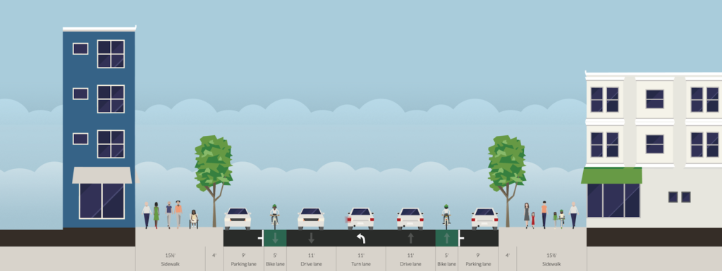
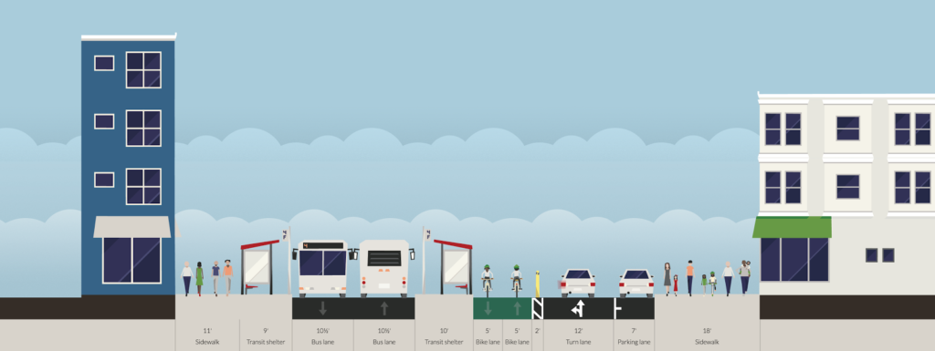
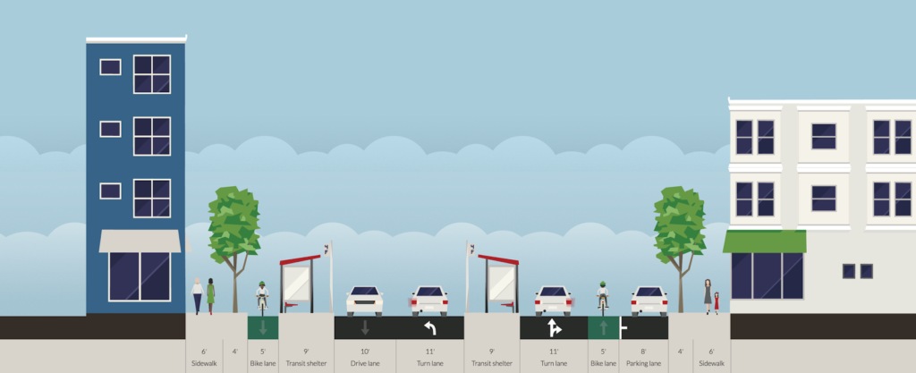
That’s a lot of space for cars, isn’t it?

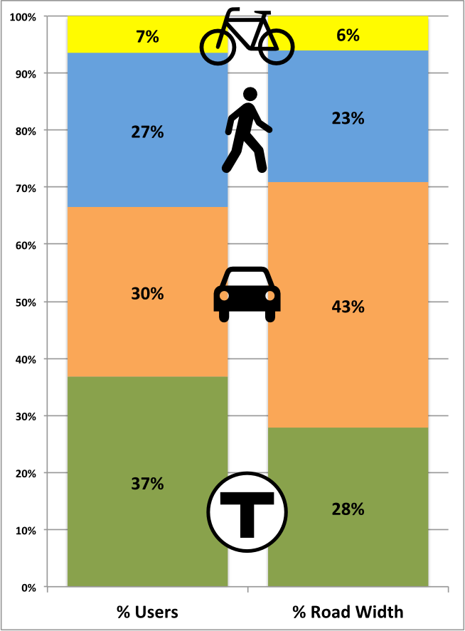
Still, the Square is remarkably car-oriented for a community where the majority of residents don’t drive as their main means of transport. Bike lanes are an afterthought, and cyclists jockey for space as buses, taxicabs and parked cars pull in and out, crossing and frequently blocking the bike lane. It is one of the most dangerous locations in the city for cyclists, which is no surprise to anyone who bikes there. For pedestrians, crosswalks are frequent and Mass Ave and Prospect Street have five second leading pedestrian intervals, but sidewalks are still congested, especially near transit stops which often fill with riders if a bus is a few minutes off of its headway.

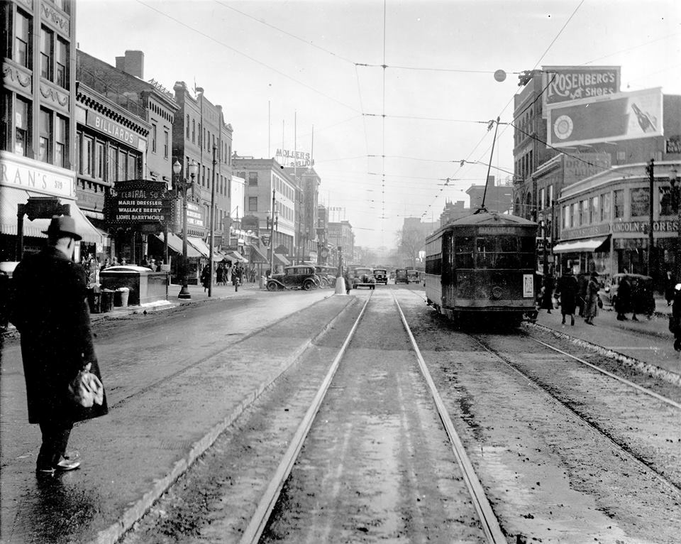
Back in the day, transit riders boarded streetcars in the center of the street
in Central Square (these were not exclusive lanes but rather “safety zones
where passengers could board streetcars while automobiles passed on the
right; cars could pass on either side of the platform.

And transit riders? They have it worst. Long queues can form entering and exiting the too-narrow subway entrances at Pearl Street. Bus riders have a small shelter on Mass Ave, which is often inadequate for the number of riders waiting for the multiple routes which board there, and riders on Route 70 are forced to board buses a block away from the Square, on Green Street, with minimal shelter, narrow (just five feet wide!) sidewalks and on a grungy back street which is often so choked with traffic the bus can barely manage a crawl between the stops.

Unlike most other parts of the 1 Bus route, there are parallel streets in Central which could be used to alleviate traffic on Mass Ave and provide safer options for cyclists and pedestrians and better conditions for transit riders. It would require a major rethinking of how street space is used, changing the direction of Green Street and moving eastbound traffic one block to the south. That hurdle aside, Mass Ave could be reapportioned to allow for a safe, separated bicycle facility, bus stop consolidation at a single point adjacent to the Red Line (not, for many riders, a block away), and a transit-only facility stretching several blocks, free of the traffic snarls that routinely hold up buses. It would also (gasp) reduce some street parking, but the majority of businesses in Central cater to walk-in traffic, and there is ample parking at the too-numerous parking lots nearby and at the ugly-and-should-be-torn-down-for-housing Green Street Garage.

So, how do we create a Central Square where pedestrians, cyclists and transit riders are put first, and not an afterthought?

1. Green Street flips from west to east. This allows all of the traffic from Mass Ave to be shunted south on Pleasant Street by the Post Office and then left on to Green. (Franklin would probably also be flipped from east to west, which would have the added benefit of eliminating a the Franklin/River intersection, which has very poor sight lines.) Green would be two lanes wide, with one lane for through traffic and the other for deliveries and drop-offs and potentially parking between Magazine and Brookline. While this would increase traffic on Green Street, it would be mitigated by removing most if not all of the buses (more on that in a moment). Furthermore, there are very few residential buildings on Green Street, which is really mostly a service corridor for Central Square, so the impact of any additional traffic would be minimal. The street is 24 feet wide, which is wide enough for two 12-foot travel lanes.

Once past Pearl Street, traffic would be able to filter back to Mass Ave. Some traffic would take Brookline Street, mostly to zigzag across to Douglass Street and Bishop Allen. Traffic destined to Main Street could turn here, or signals could be changed to allow a straight-through move on Sidney Street. Traffic going towards Boston could continue on Green Street as far as Landsdowne, where the diagonal street allows for less severe turns.

What about westbound traffic via Bishop Allen and a transit-only corridor? There are several reasons this is suboptimal. First, it’s probably good from a political and practical sense to have some vehicular access to Mass Ave. Otherwise you wind up with some dead-ended narrow streets abutting the square. Second, the right turn for through traffic from Mass Ave to Bishop Allen is very hard to figure out. The Sidney Extension-Main-Columbia turn would be implausible increased traffic. Douglas Street is only 20 feet wide and is probably too narrow for trucks. Norfolk is 24 feet, but then you’re creating a busy turn right in the middle of the square. Finally, complete streets include cars. They just don’t make them the priority.

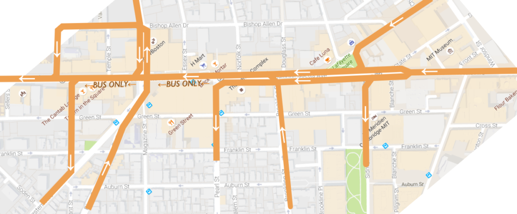
2. Mass Ave eastbound is rerouted to Green Street. As described above, all traffic from Mass Ave eastbound would be diverted to Green Street at Pleasant. Traffic wishing to turn left on to Prospect would take a right on Pleasant, and a left at Western. Light timings would be changed at Western to allow for additional traffic. Mass Ave Westbound would remain as is.

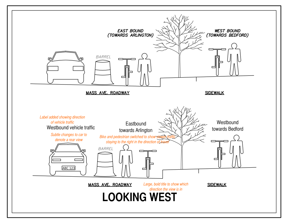
Eastbound traffic patterns for traffic to and from Mass Ave. The dashed line shows where traffic would be allowed but not encouraged; signs would direct through westbound traffic to Mass Ave to proceed to Landsdowne Street, but right turns from Brookline to Mass Ave would be permitted. For simplicity, not all traffic movements are shown.
Eastbound traffic patterns for traffic to and from Mass Ave. The main change would be the split for traffic destined to Sidney Street and Pearl Street, where turning traffic would share a separate lane with buses before turning left.

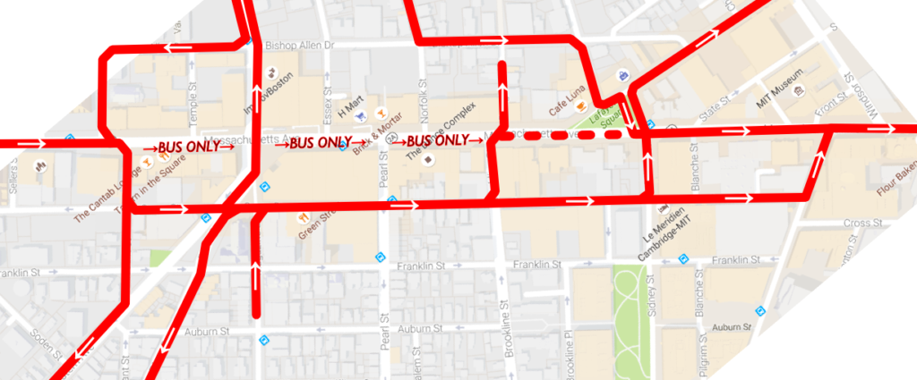
3. A two-way busway would be built on the south side of Central Square from Pleasant to Sidney. Eastbound buses would be exempt from the turn to Green Street and instead proceed directly down Mass Ave. East of Pearl Street, this busway would allow for some general traffic: right turns from Brookline Street to Mass Ave and left turns from Mass Ave to Pearl. The busway would also allow emergency vehicles (including from the nearby firehouse) to bypass gridlock in Central Square, creating BRT elements in one of the most congested areas of the 1 bus route (as opposed to, say, the Silver Line, which has bus lanes in the least congested part of the route). Bus stops would be consolidated between Pearl and Essex for betteraccess to transit. (This 160-foot long section could accommodate four 40-foot buses.) Buses would be able to loop as follows:

  • 1 is a through route. CT1 should be eliminated. Short turns could be made via Pleasant-Green-Western.
  • 47 would go left from Brookline to the busway. Loop would be made via Pleasant-Green-Western. A single-bus layover would be retained at the end of Magazine Street. This would eliminate the need for passengers to walk a block to transfer.
  • 64, when not operating through to Kendall, would loop via University Park, but instead of serving stops on Green Street, it would loop back to the busway. Left turns would be allowed for buses from Mass Ave to Western.
  • 70 would loop via University Park as above, making inbound and outbound stops on Mass Ave, eliminating the walk to Green Street and the inadequate boarding facilities there.
  • 83 and 91 would use a left-turn lane for buses only on Prospect Street (currently a painted median) to allow access to the busway. An actuated signal there would allow a left turn phase when necessary (approximately once every ten minutes, which would have a negligible effect on other traffic). Buses would then loop and layover in University Park like the 70. This would allow these routes to serve the growing University Park area, which has seen significant development in recent years. 
A busway, a cycletrack, a travel lane and even some parking! Emergency vehicles would be able to use the busway, too.

4. Eastbound bus stops would remain largely where they are on the south side of the street, but any pull-ins and bulb-outs would be removed to allow vehicles to maneuver more freely. (The additinal crossing distance would be mitigated by the bus platform mid-street.) Westbound bus stops would be placed in the center of the roadway; one between Pearl and Essex (approximately 160 feet long) and another east of Sidney Street (60′ long, for the 1 Bus only), where those buses (and Pearl Street turns) would be shunted to the left. These stops would be ten feet wide, significantly wider than the current stops on Green Street. Pedestrians transferring between the Red Line and westbound buses would have to cross just the westbound traffic lanes of Mass Ave, no longer making the trek to and from Green Street. West of Essex Street, the bus lanes would jog to the right to allow clearance between the headhouse and elevator for the main entrance to the Central Square station. The bus platform—which could be raised to allow level boarding akin to the Loop Link in Chicago—would span the distance between the Pearl and Essex crosswalks, allowing access from both ends of the platform. (The bus platform for eastbound buses could also be raised.)

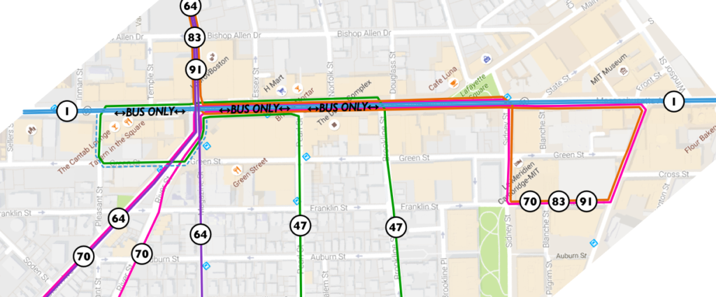
MBTA bus routes shown, including loops for routes terminating in Central. At non-rush hours, the 64 bus would follow the route of the 70. The dashed blue line shows the ability for the 1 bus to short-turn (today known as the CT1). Other buses, such as the MASCO shuttle, could also use the busway.
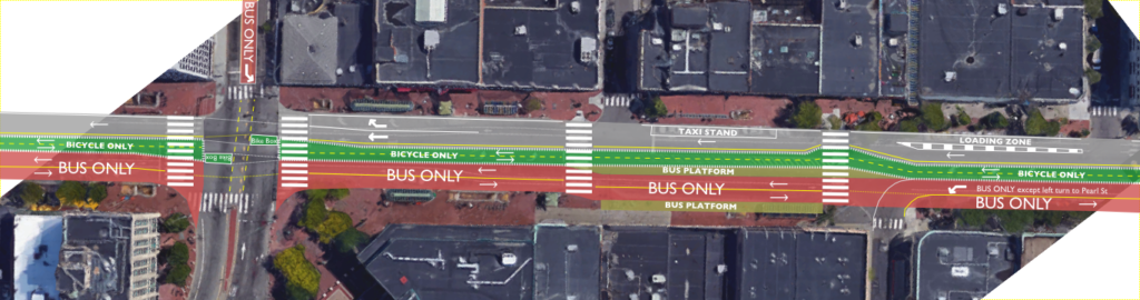
East of Pearl, the busway would allow some general traffic (left-turning cars to Pearl Street). Through traffic would remain on the north side of the street, and the cycle track would have no vehicular crossings between Brookline and Prospect.

5. In between the westbound bus stop and the westbound traffic and loading zone lane would be a 10- to 12-foot-wide cycletrack, running from Sidney to Inman. Except where adjacent to the firehouse, it would be raised above grade and separated from traffic. At either end, a separate bicycle signal phase would allow cyclists to move from existing bicycle facilities to the center of the roadway. This would eliminate the constant conflicts between cyclists, motorists and buses. Bicycle traffic calming measures would be required in the vicinity of the bus stop at Pearl Street with high pedestrian traffic, but cyclists would otherwise have an unobstructed trip from Sidney to Inman (with traffic lights at Brookline and Prospect, where a bicycle phase might be necessary for right turns). For turns to Prospect and Western, bike boxes would be provided to allow two-stage turns. For turns to minor streets, cyclists could use areas adjacent to crosswalks. Since bike lanes in Central Square are frequently blocked by vehicles, this would wholly eliminate these issues.

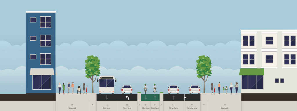
A bus-only facility would dramatically improve facilities for transit passengers, a cycletrack would eliminate car-bike conflicts make biking through Central much safer, and a bus platform would decrease crossing distances for pedestrians. And there would still be ample room for taxis and loading zones on the westbound side of the street.

Why not side-of-street cycletracks? A few reasons. If it weren’t for the location of the Red Line headhouses, it would probably make more sense to have side bike lanes, but we should assume that the Red Line infrastructure are immovable. Putting the cycletrack in the middle of the street means that you don’t have right-hook issues (although right turns from the cycletrack are trickier). Second, bus stops. Central is one of the busiest bus transfers in the MBTA system without an off-street facility (think Alewife, Harvard, Forest Hills, Ashmont, Sullivan, Kenmore, etc). You’d need large floating bus stops and really need to pull the cyclists back from the street. Third: pedestrian traffic. There are a lot of pedestrians in Central Square. A successful cycletrack would need significant separation from the sidewalks to avoid becoming choked with pedestrians. This is a lot easier to do in the middle of the road than it would be alongside the sidewalks. Finally, the busway creates the need for a buffer between the westbound travel lane and the buses, which is a perfect place for the cyclists. You do have two points of conflict on either end of the cycletrack to transition from the existing lanes (which can be signalized) but otherwise have relatively clear sailing for cyclists devoid of the current maze of turn lanes, parking spaces and taxi stands.

East of Sidney Street, Mass Ave westbound would split, with left-turning traffic to Sidney and Pearl to the left of the bus stop island for the 1 bus (the floating stop on the south side of the street would serve the 1, as well as routes short-turning at University Park). The westbound bike lane could be cycletracked inside parking. Both bike lanes would have a signal phase at Sidney to allow a safe transition from the side of the street to the center-street cycletrack.

6. The westbound lanes of Mass Ave would be 22 to 24 feet wide, allowing the current travel lane as well as a wide area for a loading zone for area businesses, a taxi stand and other pick-ups and drop-offs near the transit station. These uses would no longer conflict with bicycle traffic. Some street parking could be provided, but it is probably best relegated to side streets nearby or parking lots (there are generally few on-street spots today anyway).

All of this might increase traffic congestion for some drivers. (Horrors!) But it would benefit the large majority of users of Central Square who arrive by transit, walking or biking, or a combination of all of them. Central once had transit stops in the center of Mass Ave (for streetcars), and it’s time that those users were the priority for the heart of Cambridge, not an afterthought.

Quick thoughts on the ½ block Mass Ave bike lane

I took the liberty to bike home this morning from running across the Harvard Bridge to check out the new bike lane there (sans phone, however, so no sexy pictures). Here are some quick observations:

  • It needs flexi-posts. Too many drivers are used to using it as a right turn lane. Once installed, they should preclude that, which is where the real safety improvements come (that and No Turn on Red markings, which are long overdue; perhaps DCR and MassDOT will match with NTOR on the Cambridge side of the bridge). Whatever system is put in place needs to be kept year-round, with a snow-clearance plan (which includes the bridge, which MassDOT did not clear this past winter).
  • Flexi-posts would be nice on to the bridge, which is always a bit harrowing with catch basins on the right and traffic on the left, but that would mean it would be hard to pass slower cyclists, a relatively frequent occurrence. Perhaps intermittent (every 30 meters/Smoots) posts that would still allow cyclists to change lanes would work. It’s also MassDOT territory and interagency cooperation is not a thing in Massachusetts.
  • Once in place, there will no longer be the merge/bus stop/right turn hell that has been the situation there for years. (Or as vehicular cyclists would call it: paradise. To be dead serious for a moment: the previous situation at Mass and Beacon was exactly what vehicular cyclists advocate for: a free-for-all with bikes acting as cars. People died because of it. It is high time for the vehicular cyclists to be banished to the dustbin of history.)
  • The bike lane westbound/northbound on Mass Ave (on the other side) has been striped quite wide—at least 8 feet—coming in to Beacon, where it shares a bus stop. This means that both travel lanes are just nine feet wide. If nine foot lanes are okay (and they should be) you could dramatically improve Mass Ave.
  • The current lane off the bridge is probably the most important single block for a bicycle facility in the City of Boston, and perhaps the Commonwealth. It is heavily used, with high conflict rates and a steep downhill off the bridge which sent cyclists flying in to a sea of cars and bad pavement. So it’s the right place to start. But it’s just a start. The lane really needs to be extended all the way down Mass Ave (as has been proposed here and elsewhere). 
  • By moving the bus stop to Marlborough, a few parking spaces will be lost. And the M2 will have to find a new stop (I’m not sure where). In fact, it might make sense for both bus stops to be moved to either side of the Marlborough intersection, which would make my previous plan even more feasible (expect a redraft of that in the next couple of days).
  • Still, I think that this is a huge change, because the city eliminated a lane of traffic without a months-long, drawn-out “traffic study” which would claim a reduction in LOS and that therefore a bicycle facility couldn’t be accommodated. Is it reactive instead of proactive? Yes. And that needs to change. But it sets a precedent: we can remove traffic lanes in the name of safety. And it’s now time to act for a safer Mass Ave, a safer Beacon Street, and safer streets all around.

It’s time to radically rethink Mass Ave and Beacon St

There’s an intersection in Boston, at the end of the Harvard Bridge, that I bike through all the time.

So do a lot of other people.

Today, one of those people didn’t make it.

Legend:
White: Roadway
Yellow: Exclusive transit
Green: Bicycle
Gray: Pedestrian
Blue: Parking
“Wavy” = barrier or curb

The corner of Mass Ave and Beacon Street is dangerous. Like, really dangerous. It’s relatively narrow in both directions (i.e. not wide enough to easily separate uses), but still wide enough that cars can get up a decent amount of speed. It is heavily traveled by many modes, and has frequent buses and other large vehicles. Some of those things aren’t going away (no, we can’t kick the #1 bus out). We know it’s dangerous; we have for some time. Yet we’ve done nothing about it. Today, that has yielded tragic results.

But there are certainly things we could do. The intersection is dangerous for a variety of reasons:

  • The bike lane disappears so that there can be three (3) lanes on the Boston-bound side.
  • Buses pull in and out of the bike lane to make passenger stops.
  • Bicyclists have no leading signal, so they have to go at the same time as cars.
  • Cyclists accelerate down the grade off the bridge, quickly catching up on turning traffic.
  • Trucks swing out to make wide right turns from the left lane, oblivious to bicycle traffic three, and cyclists don’t see the trucks turning right; trucks then turn across these lanes.
  • There is frequently heavy traffic, so cyclists have to weave between stuck cars. When there’s less traffic, wide lanes allow cars to go fast.
  • Beacon Street has three lanes of traffic east of Mass Ave, making it feel much more like a highway than a city street, despite traffic counts that would barely require two. (It has fewer cars than parallel Comm Ave, which has—wait for it—two lanes of traffic.)
  • There are minimal bicycle facilities on Beacon Street, making cycling there especially dangerous.
As usual, most of the real estate on the street is given over to cars. It was seen as a real coup when Nicole got parking removed on one side of Mass Ave and bike lanes installed in 2012 and, at the time, it was. But we’ve come a long way since then. Comm Ave is getting protected bike lanes. And one of the first protected intersections in the country, which is downright Dutch! We’re fixing bicycling safety issues in other parts of the city: it’s high time we did so at this intersection as well.
There’s another element at play, too, which you can see if you look at the diagram that’s been staring you in the face since you started reading this post: this is a huge transit corridor. With the 1 and CT1 buses, it handles 15,000 bus riders per day, add in the M2 Shuttle and bus passengers account for 20,000 people on Mass Ave, despite lousy service and near-constant gridlock impacting schedules. Given that traffic counts for the bridge are only about 25,000, it means that if you’re crossing the bridge, there’s a better than even chance that you’re on a bike or a bus, as I’ve pointed out before. Yet even with the new lanes (thanks, MassDOT!), we still give 82% of the bridge space to cars, with no priority for transit.
So here’s what you could do:
  • Put a bus lane on the Harvard Bridge, extending south along Mass Ave to Boylston Street (and perhaps beyond). Build a new station at Boylston in the center of the roadway (you’d need left-door buses for this, but these exist), safety-zone type stops like shown here but both adjacent to the Hynes station, or exclusive bus lanes on the sides with signals to allow the buses to move to the center of the roadway. (This could be extended further south as well, but traffic is usually not as bad south of Boylston.) At Beacon Street, install offset bus stations on either side of the street (there’s not room for a single station) with signal priority. Modal equity is a good thing. And despite my feelings about the ITDP’s bus study (this would hardly qualify as gold standard by their rankings with offset stations and lanes demarcated by paint and not concrete, but there’s not room for that), I think this is a great place for bus lanes! And by putting them in the center, you reduce any instances of buses having to cross and block the lanes to make passengers stops.

    This will require removing only a couple of parking spaces on Mass Ave as the busway transitions in to the middle of the street to allow parking on one side. As far as I can tell, the businesses in the area have done fine without parking. Until Boylston, there are two ways of dealing with left turns. One would be to allow left turns from the bus lane, with a green light preceding any bus arrival to clear the lane. Even better would be to ban left turns all together, like San Francisco has on Market Street. This is safer for cyclists, pedestrians and vehicles, and addresses a major congestion issue (while allowing longer phases for straight movements). The few vehicles needing to go left could make a series of three rights (right on Comm/Newbury, right on Charlesgate, right on Marlborough/Comm) instead.

    (Why not at Beacon, too? A northbound driver past Marlborough would have to go all the way to Cambridge to get back. So the left turn lane there fits and allows that movement, although it could be reassessed if it received very little use.)

  • On Mass Ave, the southbound bike lane should be separated to the intersection. This is the most dangerous area, where cyclists are most likely to be right hooked as one was today. Bicyclists should have a separate phase to cross when there will be no other cross traffic allowed. At other times, cyclists could have a red signal for the straight or left (yes, left; more in a second) movement, but a green signal for a right turn on to Beacon Street. In addition, a curb or bollard south of the cycletrack on Beacon would require large trucks turning right to do so with much better visibility for cyclists, which could preclude the need to use specific bicycle signals to keep the users safe.
  • South of Beacon, Mass Ave would be a bike lane without separation to fit in the bus station, but would transition to a parking-protected separated facility.
  • Going northbound, the protected lane would similarly lose its protection at the stop. However, with no right turns possible, there would be no worry of a right hook. It would regain protection across the Harvard Bridge.
  • The Harvard Bridge is currently two five-foot bike lanes and four 11-foot travel lanes. By reducing the travel lanes by one foot each, a two-foot buffer is easily attainable.
  • Now, on to Beacon Street. Beacon Street is easy. It’s currently three 12-foot travel lanes and two six-foot parking lanes. There is no need for three lanes given traffic volumes on the street (just 7500 to 9500 per day!); two would suffice. If you pulled the width back to ten feet, you’d have 16 feet available to add two feet to each parking lane (8 feet instead of 6), a 2 foot buffer and a 10-foot-wide, two-way protected bike lane all the way to the Common. Which is why you’d need the aforementioned left turn from Mass Ave.
This is all doable. The big hurdle is convincing people that cars might have to wait in some more traffic so that transit riders, bicyclists and pedestrians—the majority of the users in the area—can have a faster and safer experience. We’ve seen what happens with the current layout: gridlock, congestion, pollution, with deadly results. It’s high time we made a change.

Update 8/9: In the original diagram, I had near-side bus stops, but it is noted that
far-side bus stops might work better from a transit signal priority point of view, and to allow for larger vehicles to make right turns. This turned out to be the case from a physical point of view as well inasmuch as it doesn’t require the busway to jog nearly as much if the parking moves from one side of Mass Ave to the other. The main issue is that cars would now be aiming right at the “safety zone” style bus stops and an errant car could drive in to a group of waiting passengers, but a protruding island could guide them towards the roadway. (By minimizing the amount of zigging and zagging, it would allow for more parking as well.) Another issue is that this would not accommodate the M2 Shuttle as well, as it turns right on to Beacon Street, but it could continue and go right on Mass Ave or have a separate stop further down Beacon Street. I’ve also added left turn boxes for cyclists. If you’re interested, the original design is shown to the left.

I also have a design shown to the right which has much less transit priority but puts a two-way bikeway in the center of Mass Ave (with enough room for a jersey-style crash barrier on either side). While it would provide a quite-safe bicyclist experience for those going straight, there are a number of significant downsides:

  • Bicyclists turning right would have to cross traffic at an intersection, and could not pull to the curb.
  • It would be very difficult to design a means for cyclists to enter and exit this cycling facility from the Paul Dudley White bike path along the river.
  • Turning movements for cyclists between Beacon and Mass Ave would also be difficult as there would be nowhere for cyclists to wait for a turning phase, which would be required for all turns.
  • Where, inevitably, bike lanes move from the middle to the side it would be an awkward transition (as is the case with the Comm Ave bike lanes at Charlesgate). 
  • The potential for transit improvements are minimal. The main benefit is that there would be no need to transition transit from the middle to the center as would be the case in other scenarios, but buses can more easily signal across mixed traffic. However, transit would only share a lane with right-turning vehicles, and the only way to really improve bus speeds would be to somehow assure that drivers didn’t use the right turn lane to bypass traffic and then attempt to merge back in. Good luck with that.
Update 8/20: Clarified a few things and slightly changed the diagram.

The Comm Ave conundrum—in a chart

We’ve been covering Commonwealth Avenue a lot recently on this page, and here’s another post (likely not the last). In the last couple of days we’ve seen the Boston Globe editorialize that the current design is subpar, which, despite the supposed end of print media, is a decently big deal. This post will be somewhat short on words, but I think get across an important point: the current design gives drivers more room than they deserve, and gives the short shrift to everyone else: transit users, bicyclists and pedestrians. Many thanks to TransitMatters for digging through the BU transportation plan (several hundred pages, including the entire MBTA Blue Book appended to the end) and finding their peak hour traffic counts. He presented it as a table, I simplified it a bit (grouping all transit riders) and show it to the right.

It’s plainly obvious who the current plan favors: automobiles. They are only 30% of the street’s traffic, but are afforded 43% of the streetscape. Transit carries significantly more people but sees only two thirds of the street space, and pedestrians and bicyclists also see their portion of the street relatively small compared with the actual use. Plus, car traffic is flat or declining, while bicycling and walking grow, but instead of encouraging such growth, we’re shifting them to the edge in narrow, dangerous conditions, so we can have faster vehicles.
Expressed another way, transit, vehicles and pedestrians transport between 61 (bikes) and 75 (transit) people per linear foot of street width per hour. Cars transport 39. Does it make sense to afford the most street space to the least efficient mode?
(Note, these measurements were made from the already-build segment of the street east of the BU Bridge; the new plans seem quite similar.)
Now, imagine, if the road was built according to the actual use, not prioritizing it for vehicles. Transit would go from 46 feet to 61 feet, although those 17 feet aren’t really needed for transit, so they could be used for other modes. Cars would be reduced from 71 to 49. That’s still enough for four 10 foot travel lanes and parking on one side. Does BU really need on-street parking lanes on both sides of the street? Pedestrians get an extra six feet, three on each side, and bikes go from 10 to 11 feet. Of course, you still have those 17 transit feet. You could put in another 9 foot parking lane (see, parking!), and then use the remaining eight feet to provide a four foot protected buffer for each of the bike lanes. (Or a three foot bike lane buffer and make the right lanes 11 feet instead of 10 since they will be host to buses.)
Or we could overbuild the road for cars at the expense of all other users.

Poor signage harms viability of the temporary cycletrack in Lexington

Two cyclists correctly using the temporary “cycletrack” along
Massachusetts Avenue in Lexington.

Biking through Lexington a few weeks ago, I noticed that the Minuteman Bikeway was set to close for most of May for construction work related to a collapsed culvert. And at an opportune time: the first day of construction would coincide with Bay State Bike Week‘s start, and it would last through the rest of the month, Memorial Day included. The Minuteman is certainly a recreational asset, but is also heavily used for commuting; the site of the construction is only five miles from the Alewife MBTA station, where many cyclists transfer to the Red Line or other bicycle facilities.

The only logical detour? Massachusetts Avenue, a.k.a. Routes 4, 225 and 2A. In other words, it’s not a quiet country lane. While some cyclists are comfortable riding the road (and it can be faster cycling than the bike path), many are not. Ideally, there would be a detour around the construction work. But with a narrow right-of-way and heavy construction equipment, this is not possible. So the town of Lexington, to its credit, did something remarkable: they banned parking along Mass Ave and “barreled off” a lane of traffic to create a contraflow cycletrack for a half mile around the closure. As far as I know, it is the first such facility in the state.
And if you want to see it, you better act fast: it will be gone in two weeks.
As well-intentioned as this temporary infrastructure is, the communication to the public could be better: signage both at the site and even online is confusing to cyclists who will already be thrown out of their comfort zone. The crux of the issue is that when you are implementing a new and different infrastructure plan, you need to be clear to the users what they should do. Unfortunately, both signage at the start and end of the lane and at the project’s website (description and sketch; both pdf) is ambiguous, and thus users were unclear as to how to traverse this section of roadways. It seems that highway engineers created a good plan, but the signage was not properly thought through and vetted. 
According to the detour notice (pdf), the following detours occur:
  • Westbound bicycle traffic will take a left on to the Seasons Four driveway, and a right on to the Mass Ave sidewalk, following the sidewalk to Woburn Street and taking a left to get to the trail crossing and proceed up the trail.
  • Eastbound bicycle traffic will take a right on to Woburn Street. It will then turn left across Woburn Street and proceed on the far-left (north) side of Massachusetts Avenue between a row of barrels and the curb—this is the (temporary) protected, contraflow cycletrack. At the end of this facility, they will take a left on to the Seasons Four driveway, and proceed as normal along the path. 
  • Any cyclists who wished to use the roadway along Mass Ave should use the traffic lanes as usual but should note that lane width will be constricted by the construction.
In other words, a cross-section of Mass Ave looking westbound would look something like this:

Simple right? Well, not really. Here are the problems with the communication:
  • The project notice is buried on a town website. It’s easy enough to find with a Google search but not well publicized. Once you find it, however, it is a poorly-formatted word-doc-turned-PDF. I don’t want to toot my own horn (or, pardon me, ring my own bell), but the bulleted section I wrote above is much more informative than trying to parse the information from this document.
  • The sketch which accompanies this notice (but is not linked from it) is clean and simple, but unfortunately leaves out important information to show users how to use the facility. It shows what appears to be the front of a car in the westbound travel lanes, when in fact this should be the rear of a vehicle. This is a fine engineering mock-up, but this is a case where more detail is necessary. It also is too simplified to show the direction of travel, and would be well-supplemented by an overhead sketch as well. It even lacks a proper title, such as “Mass Ave looking westbound” for user orientation. You certainly don’t want information overload, but in this case, important information is left out.
  • The signage onsite is abundant, but lacks important information. In a case such as this one, it is not enough to use uniform highway signage: you are dealing with a different user group, and with a situation which is unique. And even then, the signage is ambiguous. Imagine showing up as a cyclist and trying to make heads or tails of the picture below. Kind of difficult.
  • The written sign shows a picture of a bicycle and pedestrian (fine) and then the text “Temporary shared use trail. Keep right.” Keep right of what? Is this referring to the sidewalk or to the “cycletrack” lane? Does it mean “keep to the right of the sidewalk” or “keep to the right of the cycletrack” or “of the sidewalk and cycletrack, use whichever is furthest right”? 
  • Good idea, poor signage. This sign makes very little sense.
    Do they mean keep to the right of the on-street lane, or
    keep to the right of the sidewalk? Who knows!
  • Below this sign is a which shows two directional arrows (which bend for no particular reason) around a center island. This is also very ambiguous. Does the island refer to the area between the sidewalk and the “barreled off lane”? Or does it refer to the barrels? Is it telling westbound cyclists to use the “cycletrack” and eastbound cyclists to use the roadway (presumably with traffic on the other side)? Coupled with the signage above, it is no closer to making any sense.
What it needs is more of a cross-section, with words and pictures (see above). Yes, it might be a larger sign, but it would also make it much clearer who was to use the trail, and where. Many trail users take the path daily, so a clear sign on the first day would allow them to properly use the facility during the entirety of the construction. This was, unfortunately, not the case.

As for the sketch, a few minor tweaks could make it more usable. Here is the original sketch, and below my retouched sketch with some annotation regarding changes. It’s still not perfect, since it doesn’t show the whole road, but it at least leaves less room for confusion and interpretation.