Quick thoughts on the ½ block Mass Ave bike lane

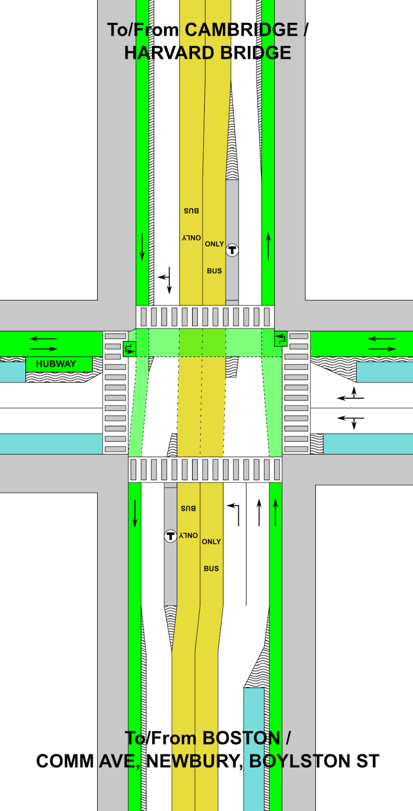
I took the liberty to bike home this morning from running across the Harvard Bridge to check out the new bike lane there (sans phone, however, so no sexy pictures). Here are some quick observations:

  • It needs flexi-posts. Too many drivers are used to using it as a right turn lane. Once installed, they should preclude that, which is where the real safety improvements come (that and No Turn on Red markings, which are long overdue; perhaps DCR and MassDOT will match with NTOR on the Cambridge side of the bridge). Whatever system is put in place needs to be kept year-round, with a snow-clearance plan (which includes the bridge, which MassDOT did not clear this past winter).
  • Flexi-posts would be nice on to the bridge, which is always a bit harrowing with catch basins on the right and traffic on the left, but that would mean it would be hard to pass slower cyclists, a relatively frequent occurrence. Perhaps intermittent (every 30 meters/Smoots) posts that would still allow cyclists to change lanes would work. It’s also MassDOT territory and interagency cooperation is not a thing in Massachusetts.
  • Once in place, there will no longer be the merge/bus stop/right turn hell that has been the situation there for years. (Or as vehicular cyclists would call it: paradise. To be dead serious for a moment: the previous situation at Mass and Beacon was exactly what vehicular cyclists advocate for: a free-for-all with bikes acting as cars. People died because of it. It is high time for the vehicular cyclists to be banished to the dustbin of history.)
  • The bike lane westbound/northbound on Mass Ave (on the other side) has been striped quite wide—at least 8 feet—coming in to Beacon, where it shares a bus stop. This means that both travel lanes are just nine feet wide. If nine foot lanes are okay (and they should be) you could dramatically improve Mass Ave.
  • The current lane off the bridge is probably the most important single block for a bicycle facility in the City of Boston, and perhaps the Commonwealth. It is heavily used, with high conflict rates and a steep downhill off the bridge which sent cyclists flying in to a sea of cars and bad pavement. So it’s the right place to start. But it’s just a start. The lane really needs to be extended all the way down Mass Ave (as has been proposed here and elsewhere). 
  • By moving the bus stop to Marlborough, a few parking spaces will be lost. And the M2 will have to find a new stop (I’m not sure where). In fact, it might make sense for both bus stops to be moved to either side of the Marlborough intersection, which would make my previous plan even more feasible (expect a redraft of that in the next couple of days).
  • Still, I think that this is a huge change, because the city eliminated a lane of traffic without a months-long, drawn-out “traffic study” which would claim a reduction in LOS and that therefore a bicycle facility couldn’t be accommodated. Is it reactive instead of proactive? Yes. And that needs to change. But it sets a precedent: we can remove traffic lanes in the name of safety. And it’s now time to act for a safer Mass Ave, a safer Beacon Street, and safer streets all around.

It’s time to radically rethink Mass Ave and Beacon St

There’s an intersection in Boston, at the end of the Harvard Bridge, that I bike through all the time.

So do a lot of other people.

Today, one of those people didn’t make it.

Legend:
White: Roadway
Yellow: Exclusive transit
Green: Bicycle
Gray: Pedestrian
Blue: Parking
“Wavy” = barrier or curb

The corner of Mass Ave and Beacon Street is dangerous. Like, really dangerous. It’s relatively narrow in both directions (i.e. not wide enough to easily separate uses), but still wide enough that cars can get up a decent amount of speed. It is heavily traveled by many modes, and has frequent buses and other large vehicles. Some of those things aren’t going away (no, we can’t kick the #1 bus out). We know it’s dangerous; we have for some time. Yet we’ve done nothing about it. Today, that has yielded tragic results.

But there are certainly things we could do. The intersection is dangerous for a variety of reasons:

  • The bike lane disappears so that there can be three (3) lanes on the Boston-bound side.
  • Buses pull in and out of the bike lane to make passenger stops.
  • Bicyclists have no leading signal, so they have to go at the same time as cars.
  • Cyclists accelerate down the grade off the bridge, quickly catching up on turning traffic.
  • Trucks swing out to make wide right turns from the left lane, oblivious to bicycle traffic three, and cyclists don’t see the trucks turning right; trucks then turn across these lanes.
  • There is frequently heavy traffic, so cyclists have to weave between stuck cars. When there’s less traffic, wide lanes allow cars to go fast.
  • Beacon Street has three lanes of traffic east of Mass Ave, making it feel much more like a highway than a city street, despite traffic counts that would barely require two. (It has fewer cars than parallel Comm Ave, which has—wait for it—two lanes of traffic.)
  • There are minimal bicycle facilities on Beacon Street, making cycling there especially dangerous.
As usual, most of the real estate on the street is given over to cars. It was seen as a real coup when Nicole got parking removed on one side of Mass Ave and bike lanes installed in 2012 and, at the time, it was. But we’ve come a long way since then. Comm Ave is getting protected bike lanes. And one of the first protected intersections in the country, which is downright Dutch! We’re fixing bicycling safety issues in other parts of the city: it’s high time we did so at this intersection as well.
There’s another element at play, too, which you can see if you look at the diagram that’s been staring you in the face since you started reading this post: this is a huge transit corridor. With the 1 and CT1 buses, it handles 15,000 bus riders per day, add in the M2 Shuttle and bus passengers account for 20,000 people on Mass Ave, despite lousy service and near-constant gridlock impacting schedules. Given that traffic counts for the bridge are only about 25,000, it means that if you’re crossing the bridge, there’s a better than even chance that you’re on a bike or a bus, as I’ve pointed out before. Yet even with the new lanes (thanks, MassDOT!), we still give 82% of the bridge space to cars, with no priority for transit.
So here’s what you could do:
  • Put a bus lane on the Harvard Bridge, extending south along Mass Ave to Boylston Street (and perhaps beyond). Build a new station at Boylston in the center of the roadway (you’d need left-door buses for this, but these exist), safety-zone type stops like shown here but both adjacent to the Hynes station, or exclusive bus lanes on the sides with signals to allow the buses to move to the center of the roadway. (This could be extended further south as well, but traffic is usually not as bad south of Boylston.) At Beacon Street, install offset bus stations on either side of the street (there’s not room for a single station) with signal priority. Modal equity is a good thing. And despite my feelings about the ITDP’s bus study (this would hardly qualify as gold standard by their rankings with offset stations and lanes demarcated by paint and not concrete, but there’s not room for that), I think this is a great place for bus lanes! And by putting them in the center, you reduce any instances of buses having to cross and block the lanes to make passengers stops.

    This will require removing only a couple of parking spaces on Mass Ave as the busway transitions in to the middle of the street to allow parking on one side. As far as I can tell, the businesses in the area have done fine without parking. Until Boylston, there are two ways of dealing with left turns. One would be to allow left turns from the bus lane, with a green light preceding any bus arrival to clear the lane. Even better would be to ban left turns all together, like San Francisco has on Market Street. This is safer for cyclists, pedestrians and vehicles, and addresses a major congestion issue (while allowing longer phases for straight movements). The few vehicles needing to go left could make a series of three rights (right on Comm/Newbury, right on Charlesgate, right on Marlborough/Comm) instead.

    (Why not at Beacon, too? A northbound driver past Marlborough would have to go all the way to Cambridge to get back. So the left turn lane there fits and allows that movement, although it could be reassessed if it received very little use.)

  • On Mass Ave, the southbound bike lane should be separated to the intersection. This is the most dangerous area, where cyclists are most likely to be right hooked as one was today. Bicyclists should have a separate phase to cross when there will be no other cross traffic allowed. At other times, cyclists could have a red signal for the straight or left (yes, left; more in a second) movement, but a green signal for a right turn on to Beacon Street. In addition, a curb or bollard south of the cycletrack on Beacon would require large trucks turning right to do so with much better visibility for cyclists, which could preclude the need to use specific bicycle signals to keep the users safe.
  • South of Beacon, Mass Ave would be a bike lane without separation to fit in the bus station, but would transition to a parking-protected separated facility.
  • Going northbound, the protected lane would similarly lose its protection at the stop. However, with no right turns possible, there would be no worry of a right hook. It would regain protection across the Harvard Bridge.
  • The Harvard Bridge is currently two five-foot bike lanes and four 11-foot travel lanes. By reducing the travel lanes by one foot each, a two-foot buffer is easily attainable.
  • Now, on to Beacon Street. Beacon Street is easy. It’s currently three 12-foot travel lanes and two six-foot parking lanes. There is no need for three lanes given traffic volumes on the street (just 7500 to 9500 per day!); two would suffice. If you pulled the width back to ten feet, you’d have 16 feet available to add two feet to each parking lane (8 feet instead of 6), a 2 foot buffer and a 10-foot-wide, two-way protected bike lane all the way to the Common. Which is why you’d need the aforementioned left turn from Mass Ave.
This is all doable. The big hurdle is convincing people that cars might have to wait in some more traffic so that transit riders, bicyclists and pedestrians—the majority of the users in the area—can have a faster and safer experience. We’ve seen what happens with the current layout: gridlock, congestion, pollution, with deadly results. It’s high time we made a change.

Update 8/9: In the original diagram, I had near-side bus stops, but it is noted that
far-side bus stops might work better from a transit signal priority point of view, and to allow for larger vehicles to make right turns. This turned out to be the case from a physical point of view as well inasmuch as it doesn’t require the busway to jog nearly as much if the parking moves from one side of Mass Ave to the other. The main issue is that cars would now be aiming right at the “safety zone” style bus stops and an errant car could drive in to a group of waiting passengers, but a protruding island could guide them towards the roadway. (By minimizing the amount of zigging and zagging, it would allow for more parking as well.) Another issue is that this would not accommodate the M2 Shuttle as well, as it turns right on to Beacon Street, but it could continue and go right on Mass Ave or have a separate stop further down Beacon Street. I’ve also added left turn boxes for cyclists. If you’re interested, the original design is shown to the left.

I also have a design shown to the right which has much less transit priority but puts a two-way bikeway in the center of Mass Ave (with enough room for a jersey-style crash barrier on either side). While it would provide a quite-safe bicyclist experience for those going straight, there are a number of significant downsides:

  • Bicyclists turning right would have to cross traffic at an intersection, and could not pull to the curb.
  • It would be very difficult to design a means for cyclists to enter and exit this cycling facility from the Paul Dudley White bike path along the river.
  • Turning movements for cyclists between Beacon and Mass Ave would also be difficult as there would be nowhere for cyclists to wait for a turning phase, which would be required for all turns.
  • Where, inevitably, bike lanes move from the middle to the side it would be an awkward transition (as is the case with the Comm Ave bike lanes at Charlesgate). 
  • The potential for transit improvements are minimal. The main benefit is that there would be no need to transition transit from the middle to the center as would be the case in other scenarios, but buses can more easily signal across mixed traffic. However, transit would only share a lane with right-turning vehicles, and the only way to really improve bus speeds would be to somehow assure that drivers didn’t use the right turn lane to bypass traffic and then attempt to merge back in. Good luck with that.
Update 8/20: Clarified a few things and slightly changed the diagram.

Bus Lanes on the Harvard Bridge

April was Bus Month here at Amateur Planner, and May is showing no signs of slowing down. I noticed recently that in a traffic jam on the Harvard Bridge (which occur regularly, especially during baseball season), there are not many buses on the bridge, but they carry a large portion of the people crossing it. So I waited for the next traffic jam on the bridge (not a long wait) and went to take a photograph, which I then annotated:

This was taken at the 250 Smoot marker (so about two thirds of the way to hell), and I noted that, in stopped traffic, there were 20 cars per 100 Smoots (this is a bit more than 25 feet per car; Smoot markers make it really easy to quickly measure things). I took a quick census of the number of people in each car (appeared to be about 1.3) and set about making the graphic above. (The bus numbers account for one at all-seated capacity, one at normal standing capacity, and one at crush load.)
Then I tweeted it, and it may have gotten retweeted a couple of times.
There was one bizarre (in my opinion—and I’m really not sure if it’s uninformed or malicious) response thread, which amounted to the following (as requested by the Tweeter, the full conversation is below):
This is where the bus does go. (1/4 and
1/2 mile buffers of MBTA bus routes.)
So, pretty much everywhere.

Responder: Plenty of people need to get where buses don’t go.
Me: I’m fine with them having one lane of the Harvard Bridge, and the buses go a *lot* of places; if they ran faster than cars, more people would take them.
Responder: So glad you’re not making the rules.
Me: Here are areas within 1/4 and 1/2 miles of bus routes, where again are people going that the buses don’t go? [See map at right.] And why should my tax $$ go to pay for buses to sit in traffic so cars can … sit in traffic? >50% of the people on the bridge are in buses. Why not give them 50% of the space?
Responder: It’s the when, not the where. Bus schedules don’t nec. match ppl’s schedules. RedSox fans all over NE. [editor’s note: see original Tweet in thread.]
Me: So if the buses were 15 minutes faster than driving, people would take them, and anyone who *drives* to Fenway deserves a dope slap. [There’s] plenty of parking at Alewife-Riverside-Wellington-Wonderland. Trains run every 5 mins. Why should 20k+ bus passengers be delayed 10 mins for a few Sox fans?
Responder: It’s about making connections too—when too many connections get inefficient, driving works.
Me: Driving works? Tell that to the people on that bridge: people were walking faster. Bus lanes means more people opt for transit, fewer cars overall, and less traffic.
Responder: Just because buses work for you doesn’t mean they work for all.
Me: That’s the problem. They don’t work. The deck is stacked in favor of driving. I’m not saying ban cars, I’m saying let’s equalize street real estate. Why shouldn’t a bus with 50 passengers have priority over a car with 1 or 2?

But this is the usual reactionary inability to see the greater good. Take away a lane from cars, and it’s an affront to driving. An affront to freedom. Un-American. Never mind the majority of people on that bridge aren’t driving cars. They don’t matter. Still, I haven’t heard this turned in to an equity argument, so that’s kind of groundbreaking.

So the first part of this blog post is a plea: Ms. Cahill, I want to know what goes through the mind of someone who can’t see that transit efficiency is a societal benefit, and that it will amount to more people using fewer vehicles. Please email me, comment here, and discuss. I want to know.

The second part is me, trying to quantify what would happen to vehicles displaced by a bus lane on the Harvard Bridge, and what the time savings would be for bus riders as opposed to the time penalties for drivers. And, as I am wont to do, I did this in chart form. I imagined a hypothetical traffic jam stretching across the bridge (0.4 miles) in a closed system where all of the cars feed off of Mass Ave on to the bridge (this is close to the case, but some traffic does enter from Memorial Drive):

At first glance, going from two lanes to one would double the length of roadway needed to store the same amount of cars. But several other factors come in to play. First of all, the buses take up the space of 8 cars—at least. Then, we can assume that 10% of the cars remaining will shift modes: if taking the bus is all of the sudden significantly faster than driving, people will use it. And people in taxis (by my estimation, 10% of the traffic on the bridge) will likely switch in greater numbers since they’re starting closer by: I estimated 50% mode switch there. Then there’s induced demand: make the traffic on Mass Ave worse, and some drivers—I said 10%—will choose another route, whether it’s the Longfellow or the BU Bridge or further afield.

Add these together, and I would guess that traffic would increase by between 1/3 and 1/2. Assuming that traffic moves at 5 mph, this would mean an increase of 2.5 to 4 minutes for each person in a car on the bridge. But it would also mean that buses would cross unencumbered by traffic, making the trip in one minute, and saving every bus passenger 7 (this assumes that the bus lanes extend back to Vassar Street, displacing bus stops and a few parking spaces on Mass Ave through MIT). With these numbers, drivers would incur 510 minutes of additional delay, but bus passengers would save nearly three times that much time—a dramatic benefit.

Am I way off base with these numbers? I don’t think so. When the Longfellow went from two lanes to one, vehicle traffic decreased by nearly half! Traffic spread to other locations, people chose other modes (walking, biking, transit), or didn’t make trips. The traffic apocalypse that was predicted didn’t materialize, and life has gone on.

The Harvard Bridge is one of the most heavily-traveled bus corridors in the city, up there with the North Washington Bridge, the Silver Line on Washington Street, the 39/66 concurrency on South Huntington, portions of Blue Hill Avenue, some streets to Dudley and the feeder buses to Forest Hills. (All of these should have bus lanes, by the way.) The 1 and CT1 combine for more than 15,000 trips per day and, at rush hour, better than one bus every 6 minutes. The bridge also carries the heavily-traveled M2 MASCO shuttle 6 times per hour. Combined, these routes account for a full (usually crush-load) bus every three minutes—which is why in a 10 or 12 minute traffic jam there are three or four buses on the bridge at any given time—transporting at least 1000 passengers per hour.

Bus lanes would allow these bus lines to operate more reliably, more efficiently and more quickly, meaning the same number of buses could run more trips, and carry more people. Which, if they’re 10 minutes faster than cars, they’re going to be carrying! This would be something that could be tested and quantified, and it could be done as a temporary pilot with cones and paint. There is no parking to worry about, no bus stops to relocate: just set aside one lane for buses (and give buses signal priority at either end of the bridge). This would take the cooperation of MassDOT, DCR, Boston and Cambridge—and prioritize “those people” riding transit over real, taxpaying non-socialist Americans—so I don’t expect it to happen any time soon.

The new Harvard Bridge bike lane, animated-GIF style

The state, thanks in part to LivableStreets’ tireless advocacy, finally repaved the Harvard (/Mass Ave/Smoot) Bridge, and restriped the bike lane to a full five foot width. Previously it had narrowed to 20 inches at the foot of the bridge, which was substandard and dangerous. Now, it’s 5 feet wide, making it much easier to navigate on bicycle, and keeping the cars in the middle of the road. Here, in two pictures is the progress that was made:

In the animated GIF (on the right; give it five seconds), I didn’t perfectly take the picture from the same angle, so it’s not layered right on top (the “before” picture was taken the summer doing recon from a BS traffic stop). Note the location of the drain, and that while the bike in the “before” is closer to the drain, he’s outside the bike lane, while in the “after” the cyclist is further from the drain, but comfortably in the bike lane. Yes, at the edge of the frame is a Street Ambassador, the work of whom led to this better bridge. So that’s cool, too.

Also, the pictures were taken at 1:30 (standard time, November) for the after and 6:30 (daylight time, July) for the before, and the shadows are the same length.