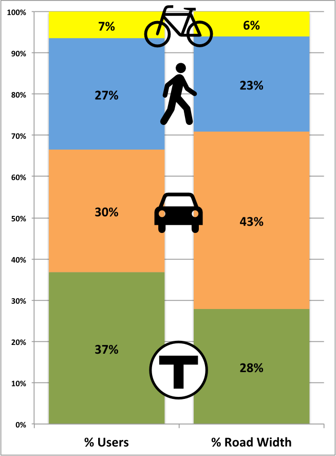
We’ve been covering Commonwealth Avenue a lot recently on this page, and here’s another post (likely not the last). In the last couple of days we’ve seen the Boston Globe editorialize that the current design is subpar, which, despite the supposed end of print media, is a decently big deal. This post will be somewhat short on words, but I think get across an important point: the current design gives drivers more room than they deserve, and gives the short shrift to everyone else: transit users, bicyclists and pedestrians. Many thanks to TransitMatters for digging through the BU transportation plan (several hundred pages, including the entire MBTA Blue Book appended to the end) and finding their peak hour traffic counts. He presented it as a table, I simplified it a bit (grouping all transit riders) and show it to the right.
It’s plainly obvious who the current plan favors: automobiles. They are only 30% of the street’s traffic, but are afforded 43% of the streetscape. Transit carries significantly more people but sees only two thirds of the street space, and pedestrians and bicyclists also see their portion of the street relatively small compared with the actual use. Plus, car traffic is flat or declining, while bicycling and walking grow, but instead of encouraging such growth, we’re shifting them to the edge in narrow, dangerous conditions, so we can have faster vehicles.
Expressed another way, transit, vehicles and pedestrians transport between 61 (bikes) and 75 (transit) people per linear foot of street width per hour. Cars transport 39. Does it make sense to afford the most street space to the least efficient mode?
(Note, these measurements were made from the already-build segment of the street east of the BU Bridge; the new plans seem quite similar.)
Now, imagine, if the road was built according to the actual use, not prioritizing it for vehicles. Transit would go from 46 feet to 61 feet, although those 17 feet aren’t really needed for transit, so they could be used for other modes. Cars would be reduced from 71 to 49. That’s still enough for four 10 foot travel lanes and parking on one side. Does BU really need on-street parking lanes on both sides of the street? Pedestrians get an extra six feet, three on each side, and bikes go from 10 to 11 feet. Of course, you still have those 17 transit feet. You could put in another 9 foot parking lane (see, parking!), and then use the remaining eight feet to provide a four foot protected buffer for each of the bike lanes. (Or a three foot bike lane buffer and make the right lanes 11 feet instead of 10 since they will be host to buses.)
Or we could overbuild the road for cars at the expense of all other users.