It’s time to radically rethink Comm Ave in Brighton

Welcome to the now-series “It’s time to Radically Rethink” where we take a roadway in the Boston area (or, in the future, elsewhere?) and really think about how it could function better. We go beyond a four-to-three conversion, as worthy as they may be, and think about how a 1950s-era street could be reformulated to serve 2020 and beyond. Our first street was Mass Ave north of Harvard Square. Next?

Comm Ave in Brighton.

Why Comm Ave? Because Comm Ave, at least west of Packard’s Corner, is obscenely overbuilt, an eight-lane highway masquerading as a local road. Originally planned as a grand parkway, most of the roadway today is a 150-foot-wide sea of asphalt, interrupted by narrow green islands and the MBTA reservation. The roadway has four through lanes, as well as two frontage roads with parking. If the roadway was used by 60,000 vehicles per day, this might be necessary. But the dirty little secret is that almost no one drives on Comm Ave.

Well, not no one. But very few people. The roadway has between 11,000 and 14,000 vehicles per day, with the higher vehicle counts west of Chestnut Hill Avenue. Some other roadways with similar traffic counts? Washington Street near Saint E’s, Cambridge Street near Inman Square, and Chestnut Street near Jamaica Pond. What do all of these streets have in common? They’re all two lanes wide. (Many two-lane streets are significantly busier.)

Comm Ave is six lanes wide. It’s a complete street for cars—and no one else.

It was originally designed as a Frederick Law Olmsted roadway (a comprehensive early history here), but you wouldn’t know that from the concrete expanse of the roadway today (portions were originally significantly narrower, but was widened in the 1950s). Before the Turnpike, the roadway may have gotten more use, but today it sees little more traffic than a side street. It serves a transportation purpose, but mostly for transit; twice as many people ride the B Line as use the roadway (13,000 people board west of Packards Corner, almost all inbound, so a similar number ride this segment outbound), yet the B line crawls along, stopping frequently for traffic lights and loading passengers on substandard, non-accessible platforms.

Pedestrians are forced on to often-narrow sidewalks, and experience long crossing times (and long gaps between crosswalks) when trying to get from one side to the other. And cyclists? Options for cyclists are to ride in the highway-like traffic lanes or ride the service roads along parked cars with frequent side streets. Despite being the widest street in the city, there are no provisions for cyclists.

So it’s time to radically rethink Comm Ave.

In the City of Boston’s defense, they have gotten a start, but as usual, they are thinking first about cars, and then about everyone else. Their presentation gives three reasons the city wants to maintain four main lanes (six total):

  • Operational flexibility including winter
  • More signal time available for pedestrians
  • Consistent with adjacent segments = safety
Huh? None of this makes sense. First of all, there are plenty of two-lane roads which can be operated in winter (all of them, it turns out). Second, more lanes means more for pedestrians to cross, so this makes no sense. And consistency = safety? How is a wider, faster roadway safer for the majority of users (cyclists, pedestrians and transit users)? If anything, a narrower road would allow for better transitions, and pleasing the wishes of motorists to see a consistent roadway should not get in the way of building something safe for everyone.

Here’s how it comes out:

There’s still a lot of pavement there. Yes, there’s a nice multiuse path, but there are still six lanes of traffic, and parking. And note that since the MBTA does not like trees near their right-of-way, the second-from-left tree would likely not exist. Without moving curbs—as this plan proposes—it’s nearly impossible to rebuild the T stations with full accessibility, nor does it provide a staged plan where, when the Green Line tracks are rebuilt, it can sensibly be integrated with the design.

So what if, instead, all of the current traffic on Comm Ave was shifted to the outside roadways, and the middle of the road became a two-mile-long linear park? In other words, what if you built the portion of Comm Ave west of Packards Corner to more resemble Comm Ave in the Back Bay than, say, the Mass Pike?

This wouldn’t be as hard as it seems, and it could be done in stages with the first stages allowing current traffic movements while providing better cycling and pedestrian facilities In the long term, by rebuilding and relocating the Green Line tracks (a project which the City of Boston should help the T to fund, similar to how other cities fund transit agency projects), it would allow a 75- to 100-foot-wide linear park stretching from Chestnut Hill Avenue to Packards Corner, unlocking the pockets of useless parkland and creating a wide, welcoming park.

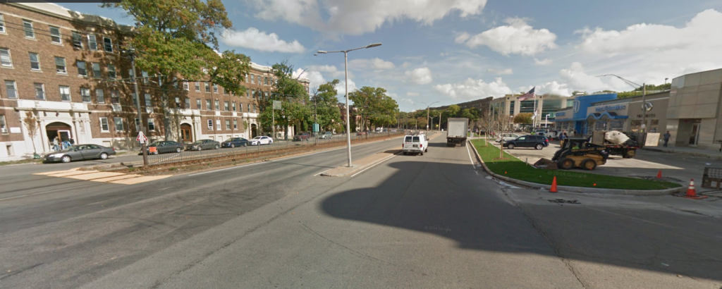
Here’s what Comm Ave looks like today:

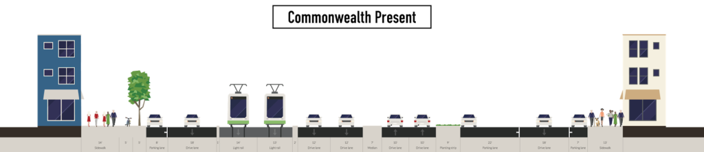
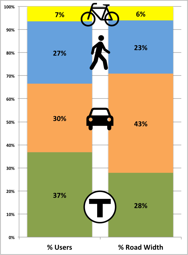
It’s 200 feet wide from curb to curb, yet two thirds of the spaces is devoted to cars. The two sidewalks take up 37 feet, and the T reservation another 30: beyond that it’s all travel lanes, parking lanes and medians to keep the lanes apart (and encourage faster driving). The city’s plan would mostly replicate this: a couple of improvements here and there, but mostly the same profile.

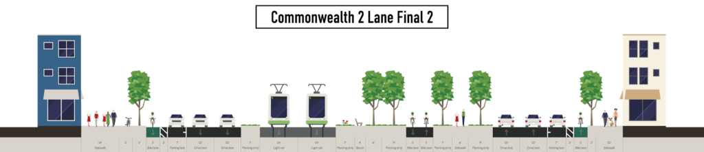
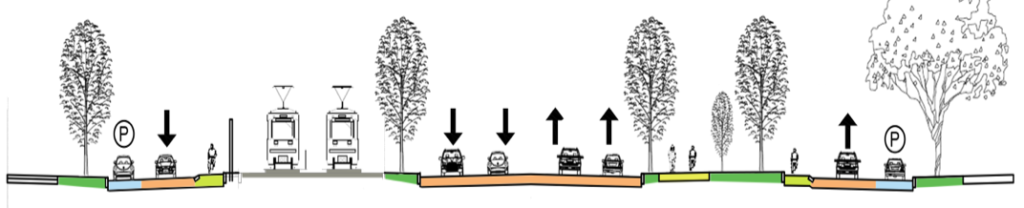
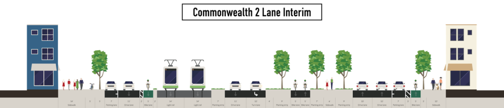
Here’s an idea of what you could have instead:

This would still allow two lanes of traffic in each direction, but rather than being a pseudo-highway in the middle of the street, cars would instead travel along the edges, and along parallel parking, to allow easy access to local businesses. (A single lane of traffic would only reduce the width of the roadway by a couple of feet, since a certain width is needed for fire apparatus, and would also allow loading zones during the annual Allston Christmas festivities.) Two lanes of traffic in each direction is plenty for this roadway, and this profile provides it. The traffic is all shunted to the side of the roadway and might move a bit more slowly, but this is a local roadway, and slower traffic would be better.

Now, this assumes the MBTA rebuilds its track, allowing a wider roadway on the north (left side of this diagram, which looks east) side. Since that’s a worthy—but longer term—project, there’s a relatively easy interim stage which can be constructed: build the final alignment of the south side (eastbound traffic) of the roadway, and leave a lane of westbound traffic to the south of the MBTA reservation. It would look something like this:

This allows for most of the beneficial elements of the roadway to be built:

  • Most of the green space
  • The curb-side cycletrack on the eastbound lane (which could be shifted to the left if there were data that showed too many turning patterns, although then it is harder to access the sidewalk and businesses)
  • The center walking path and cycling facility
But it’s also very scalable. Once the MBTA right-of-way was moved south in to the existing roadway to allow all westbound traffic to be moved to the north of the T tracks, the rest of the roadway could be filled in allowing for the final state with a wide green median between the two sides of the road.
There’s a lot more to make this street work I’m not showing here (especially on the transit side). The T stations could be rebuilt with center platforms to ease boarding and alighting, moved back from roadways to allow easier operations, fill transit priority allowing trains to proceed at speed through intersections with minor streets (i.e. every street except Harvard Ave), smooth out some of the tighter curves for the Green Line, and place the streetcar tracks in a grassy right-of-way to allow a wide green space in the middle of Comm Ave. Combined, this would speed operations by 10% or more, allowing the T to operate more service with the same number of trains.
But let’s first think a lot harder about how much pavement we actually need on Comm Ave. The city is rejiggering the current alignment. Instead, we could add several acres of parkland to the middle of Allston. We can do better.

The Comm Ave conundrum—in a chart

We’ve been covering Commonwealth Avenue a lot recently on this page, and here’s another post (likely not the last). In the last couple of days we’ve seen the Boston Globe editorialize that the current design is subpar, which, despite the supposed end of print media, is a decently big deal. This post will be somewhat short on words, but I think get across an important point: the current design gives drivers more room than they deserve, and gives the short shrift to everyone else: transit users, bicyclists and pedestrians. Many thanks to TransitMatters for digging through the BU transportation plan (several hundred pages, including the entire MBTA Blue Book appended to the end) and finding their peak hour traffic counts. He presented it as a table, I simplified it a bit (grouping all transit riders) and show it to the right.

It’s plainly obvious who the current plan favors: automobiles. They are only 30% of the street’s traffic, but are afforded 43% of the streetscape. Transit carries significantly more people but sees only two thirds of the street space, and pedestrians and bicyclists also see their portion of the street relatively small compared with the actual use. Plus, car traffic is flat or declining, while bicycling and walking grow, but instead of encouraging such growth, we’re shifting them to the edge in narrow, dangerous conditions, so we can have faster vehicles.
Expressed another way, transit, vehicles and pedestrians transport between 61 (bikes) and 75 (transit) people per linear foot of street width per hour. Cars transport 39. Does it make sense to afford the most street space to the least efficient mode?
(Note, these measurements were made from the already-build segment of the street east of the BU Bridge; the new plans seem quite similar.)
Now, imagine, if the road was built according to the actual use, not prioritizing it for vehicles. Transit would go from 46 feet to 61 feet, although those 17 feet aren’t really needed for transit, so they could be used for other modes. Cars would be reduced from 71 to 49. That’s still enough for four 10 foot travel lanes and parking on one side. Does BU really need on-street parking lanes on both sides of the street? Pedestrians get an extra six feet, three on each side, and bikes go from 10 to 11 feet. Of course, you still have those 17 transit feet. You could put in another 9 foot parking lane (see, parking!), and then use the remaining eight feet to provide a four foot protected buffer for each of the bike lanes. (Or a three foot bike lane buffer and make the right lanes 11 feet instead of 10 since they will be host to buses.)
Or we could overbuild the road for cars at the expense of all other users.

Street hierarchy planning sense … from Chicago

I was thinking the other day about planning streets. About how the default is to plan for cars first and for other users after. And about how it should work, which is that we should decide what our priorities are for each area (some areas might have transit prioritized over bicycles, some might have bicyclists prioritized over transit) and then plan based on those assumptions. For instance, if cars are not prioritized, planning shouldn’t be subjected to a level of service analysis, because vehicular delays should not affect design.

And then I saw this Tweet retweeted by Gabe Klein. And this picture:

Chicago gets it, at least in theory. Here’s how it would/should play out on Comm Ave:

  1. Pedestrians come first. Everyone (well, nearly everyone) is a Pedestrian (on Comm Ave) as they access stores, shops and buildings. Design for their mobility and safety first.
  2. Transit comes next. Take the B Line, add the 57 bus and the BU shuttles and you have 40,000 users using only a fraction of the streetscape. Keep them moving, keep them safe.
  3. Then bicyclists. Bicycles don’t use much space, but the space they do use is used efficiently for a relatively high speed of travel. Plus it’s healthy and emission free. Keep them safe and moving.
  4. Okay, we’ve come to cars. Is there enough room for cars? If the answer is yes, but it doesn’t meet some arbitrary delay guideline (level of service), too bad. We’ve accommodated everyone else. We can’t close the road to cars completely, but if they lose a lane of travel, it’s not the end of the world. If we lose a couple of drivers from Framingham, so be it.
So, kudos to Chicago for getting it right. And hopefully, Boston won’t get it wrong.

Letters, and letter responses

This page’s recent post about Comm Ave was also distilled in to a letter to the editor to the Globe that go published. And since the Globe, apparently, has a comments section, it spawned some oddly vitriolic comments. My favorite:

Remember that those hated cars are being driven by people who need to simply go to where they need to go and take care of their business, the same as anyone else. A letter like this only adds fuel to the fire of anti-bicycle bias.

Okay, first of all, did I mention bikes in the letter? Barely. This is what is so bizarre about the anti-bike people: you can write a letter about how transit should be given priority, and you’re automatically pro-bike. It’s not a dichotomy, guys. And second, the people on the trains, on foot and on bikes are also going to take care of their business. And there are a lot more of them than there are people in cars (using less street real estate to boot). But, right, let’s make sure the few people in cars aren’t delayed.

Then there’s another boo hoo letter from a suburbanite. He loves the city so much he lives 20 miles away from it. I’m not here to bash the suburbs (well, only partially), but if you make a decision to live in the suburbs and want to enjoy the amenities of the city, you should expect to encounter some resistance getting there when you go in—once every week or two. That’s the deal. If you want to live out on the Sudbury River, you damn well should have to sit in traffic if you’re going to a show. But here’s where I’m just sort of confused:

My daughter and son-in-law also love Boston, and reside there, but drive 30 and 20 miles, respectively, to their jobs. None of us would live in the city or visit it regularly if we had to rely on public transportation.

I hate to break it to you, guy, but you don’t live in the city. And your daughter and son-in-law, well, they have made a choice to live in the city despite their jobs being far afield, so there must be some draw to live there. But here’s the deal: if there wasn’t public transportation, there wouldn’t be a vibrant city. There would be Houston or Dallas or Jacksonville or some other junkhole with an oil-funded “cultural institution” surrounded by a parking lot. The doctors and shows you go to exist because it’s hard to drive there. The cultural mecca of the country—one New York City—is also hard to drive to. Boston doesn’t exist because it’s easy to get to by car from Framingham.

So, if it becomes a little bit harder for you to drive in, you have three choices:

  1. Deal with the 5 extra minutes it takes to drive because transit vehicles and bicyclists can more safely travel a less-freeway-like Comm Ave.
  2. Not come to the city and take advantage of the world-class medical facilities in Framingham. I hear there is a world-renowned symphony orchestra and art museum over in Marlborough, too.
  3. Go to this “Framingham” you speak of and take a train (information here, guy) which runs every hour to Boston for about the price of tolls and gas (actually, since you’re retired, quite a bit less), nevermind the cost of parking. Oh, and it doesn’t get stuck in traffic.
Or he could move to the city.

Update, September 21:


I’d missed this, but another retiree writes in to rebut Mr. Quitt, but this letter hits the nail on the head. Of Quitt’s letter, he writes:

I would like to shorten his last sentence by five words to read: “The attraction of Boston as a cultural, medical, and business capital is greatly enhanced by its accessibility,” leaving off “to people who drive there.”

Indeed, he points out that better transit service would increase accessibility, not just more parking. 

No need to duplicate transit on Comm Ave

NB: This got picked up on Universal Hub and there are a bunch of comments there. I’ll respond to comments in both forums, but probably here more. One note of clarification: I’m not saying that this should be the plan, but that it should be considered. Like much of the Commonwealth Avenue project, the planning process has been opaque and has had no public input. Also, this comment is a great illustration of what you could have.

The Boston Globe recently ran a story about proposed changes to Commonwealth Avenue. Of issue is that while Comm Ave is wide, it is not infinitely wide, and the changes will widen the transit reservation (mainly for safety for track workers, presumably this would also allow for wider stations), narrowing the rest of the road enough that the city is reticent to add cycle tracks, because it would narrow bus stops, and stopped buses would delay vehicles. (I’m just going to touch on the fact that there really shouldn’t be an issue with delaying traffic in favor of buses, bicyclists and pedestrians, but that’s not the scope of this post.)

What I am going to point out is that all of these issues could be mitigated by moving the 57 bus route and the BU buses to the center reservation of Comm Ave with the trolley tracks. This would result in the removal of bus infrastructure from the sides of the street—buses could instead stop at the same stations as Green Line trains. While this would be novel for Boston, it has been used in other cities, and while it could result in delays for transit riders, with better stations and transit signal priority, it would result in a better experience for all customers.

There are a variety of benefits from such a plan:

  •  Buses would move out of mixed traffic, resulting in fewer traffic delays for buses (especially at the busy BU Bridge intersection) and fewer conflicts between buses and traffic.
  • The duplicative infrastructure of having parallel bus and trolley stops would be eliminated. In their place, larger, more substantial stations could be built in the center transit median.
  • Instead of waiting for either a bus or a trolley, riders could board “whatever comes first” for short trips between Packards Corner and Kenmore Square, and riders wishing to go further east than Kenmore could take a bus to Kenmore and transfer down to a B, C or D car.
  • Removing bus stops would eliminate the conflict with buses pulling across the bike lanes when entering and exiting stops.
  • Removing bus stops would allow for more parking spaces to be added to the street. The number would be small—probably in the 12 to 18 range—but not negligible, and would assuage the (dubious) constant calls for more parking in the area.
  • In addition, there would no longer be issues with cars and taxicabs blocking bus stops, requiring buses to stop in the travel lanes.
  • Wider stations would better serve disabled users, with higher platforms better allowing wheelchairs and other disabled users to board and alight transit vehicles.
  • Narrower side lanes (parked cars are narrower than buses) would allow for more bicycle and sidewalk space, including the possibility of cycle tracks.
  • Without bus stops, there would be no need for bus passengers to get off of buses and cross a cycling facility.
  • With signal priority implemented, transit travel times through the corridor could be improved for bus and trolley riders.

The main reason to not to do this is that it hasn’t been done before. The cost to pave the trackbed—and to pave it well—wouldn’t be negligible, but since the entire corridor is under construction, it would be feasible. There would have to be some study to see if the number of vehicles would cause congestion in the transit reservation.

Additionally, there would have to be a specific signal to allow buses to enter and leave the corridor at each end of the corridor—especially the east end where they would have to merge back in to traffic. However, the 57 bus would only have to merge in to and out of the left lane since it then accesses the busway at Kenmore, which is in the center of the roadway. This could be attained with a signal activated by the approaching vehicle—again, a novelty in Boston, but by no means a procedure without global precedent.

The B line has 26,000 surface boardings, most of which travel to Boston University or through the campus and in to the tunnel. The 57 bus adds 10,000 more, and the BU Bus serves countless others. There are tens of thousands of pedestrians in the corridor, and thousands of bicyclists—it is one of the most heavily-traveled bicycle corridors in the city. Yet we are planning for cars—minority users of the corridor—first, when we should be planning for transit first (by far the largest user of the corridor by the number of passengers carried), then bicyclists and pedestrians. Cars should be an afterthought, put in to the plans after other users have been accommodated, not before. Of course, had the old A line never been converted to buses, Commonwealth Avenue would not host any MBTA services, and wouldn’t need any bus infrastructure. But that battle was lost 45 years ago.