Car Free Kendall

Kendall Square is growing, but the road network around it is not, and traffic has mostly flat-lined (probably because, without a good highway network, only so many vehicles can enter the area). But as the planet burns and the region chokes on congestion, we ought to talk about how we can improve the area with less pavement and fewer cars. At the main transit node of Kendall Square, which has tens of thousands of transit riders and other pedestrians a day, the streetscape is mostly given over to automobiles, to the detriment of the vast majority of users. What could be a great, welcoming public space is instead a wide road with plenty of street parking, for no other reason than it’s always been that way. Its time for that to change: Kendall Square should be car-free.

Which of these would you prefer to spend time in?

Unlike the Seaport, Kendall Square has been successful because of its access to transit, not in spite of it. There are no highways in to Kendall, so it has had to develop around transit access, while the Seaport has developed around the Turnpike extension, with the Silver Line mostly as an afterthought. As Kendall has grown it has become less of a desert than it was, especially as surface parking lots have been replaced by buildings or open space, and as more businesses have arrived, with a new grocery store opening recently.

Development has accelerated since 2016, especially along Main Street in the heart of the square, adjacent to the MBTA station. Until quite recently, this street epitomized the “suburban office park” feel of Kendall. Low-slung office buildings with ribbon windows wouldn’t be out of place in Bedford, Burlington or Billerica. The new MIT buildings add some spice to the square, casting off red brick for more modern designs. (In my opinion, they do this quite well, say what you will about the huge underground parking garage, the buildings, at least, are attractive. I only wish they were taller.) The four-story Coop building on top of the T, which was lifted straight from Waltham (it’s hard to cast too much blame, of course, because in the ’80s, everything was still moving out of the city, and it probably seemed deft to bring the suburbs to the city), has been torn down, and a taller, denser, and more-attractive building will take it’s place.

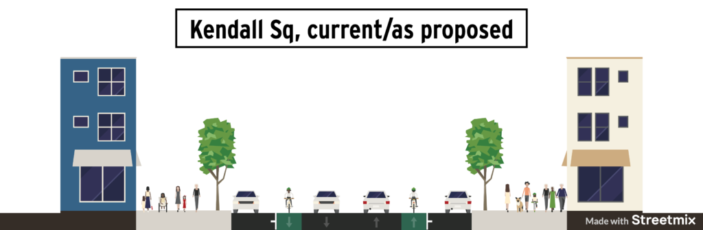
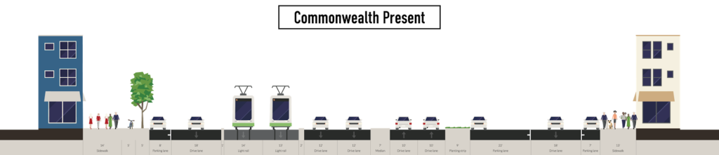
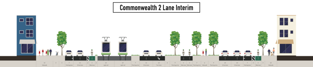
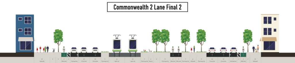
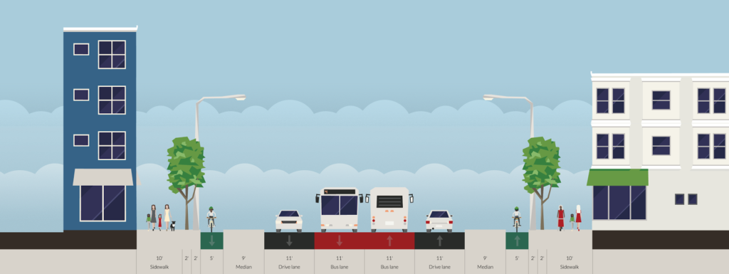
The road design 10 years ago was even worse. The median invited vehicle drivers to speed through the Square, and pedestrians were supposed to wait for a walk light at the T station to proceed across the intersection (although few waited, leading to conflicts with these speeding cars). This was replaced with a new design, but one which kept the street parking and travel lanes because even in Cambridge, we think about cars first (this came before protected bike lanes were prioritized, so the many bicyclists through the Square have to contend with pick ups, drop offs and cars darting in and out of the curb). The current design gives somewhat more priority to pedestrians, and the raised crossing significantly slows down vehicles, but even still, of the 90 feet between buildings on Main Street, the majority—50 feet—is handed over to those on four wheels.

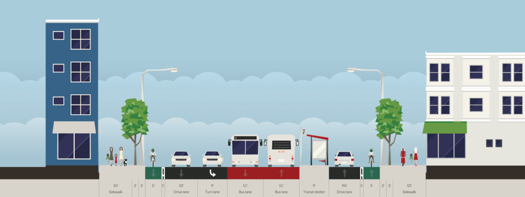
So, Kendall has made progress, but not enough. We’ve taken the worst of the 1980s superimposition of the suburbs onto the city and begun to build out more of a viable urban space. For the past few years, and for the foreseeable future, Main Street has been home mostly to barricades, scaffolding and construction equipment. But once this disappears, Main Street in Kendall Square will still be far from what is desired: it’s a place to pass through, but not a place to linger. Mostly because when the new buildings go up, the road will return to its early-2010s design: through lanes for cars, unprotected bicycle lanes for drivers to open doors into and metered street parking.

Cars are in the distinct minority in Kendall Square. Traffic counts show only about 5000 eastbound vehicles, and far fewer westbound since westbound traffic comes only from Third Street, not the Longfellow Bridge itself. Compare that to the Kendall Station, which has more than 15,000 boardings per day, meaning more than 30,000 people going in and out of the station. Add to that non-transit pedestrian trips and bicyclists and cars may only account for one tenth of the traffic in Kendall Square, especially once MIT’s SOMA project extends the campus into the square. Yet even after the current spate of construction, the plan for the road remains unchanged.

It’s time we change that.

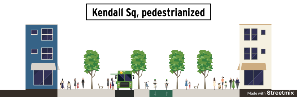
There is no need for through traffic in Kendall Square. So we should get rid of through traffic in Kendall Square. Imagine if Kendall Square was a 500′-by-100′ pedestrian plaza. With benches, and trees. Maybe a water feature. Bike lanes? Yes. Bus lanes? Maybe. Car lanes? No.

Pedestrian malls have a somewhat fraught history, but recent examples in already-high pedestrian areas have been successful. As a means to revitalize an area, they have a mixed record, but in a vital area marred by traffic, (see much of Broadway in New York City), they can be quite successful. Thus, the failures often occur when there isn’t enough foot traffic to fill the space, but this is certainly not the case in Kendall. The new construction both in the Square and nearby development sites will add to the already tens of thousands of pedestrians using the space each day. MIT’s project will turn the square from a backwater of the campus lined with parking lots (some of them gravel!) to an entryway. There will be no shortage of pedestrians.

“But we can’t just take away travel lanes in Kendall Square!”

Nonsense. We already have. Broadway has gone from two lanes to one. So have both sides of the Longfellow Bridge (only partially thanks to yours truly), and a portion of Binney Street between Third and Land Blvd. So any traffic can easily be absorbed elsewhere. Binney Street, Broadway and Ames Street can distribute these vehicles to other paths of travel. As we saw with the Longfellow shutdown, any initial traffic tie-ups will dissipate as drivers choose other routes and, with safer infrastructure, other modes. And given the climate crisis globally and congestion crisis locally, making driving in Cambridge a bit more cumbersome is good: it makes people consider their many other options, and in Kendall, we have many.

Bikes would still be able to proceed through Kendall, with a two-way bicycle facility offset from the rest of the square. This could be designed with some sort of chicane system and speed calming, encouraging through cyclists to pedal at a reasonable speed for the environment and not treat it as the Tour de Kendall. Of course, ample bicycle parking would be provided. Coming west, cyclists would share a roadway with MIT delivery vehicles from Third Street; this roadway would act as a shared street or a woonerf, where any vehicles would be encouraged by the street’s design to proceed at a human pace, and couldn’t go much faster, since their only destination would be the MIT loading dock.

There is the question of what to do with the buses. Kendall is not a major transfer point, and the busiest route through the square, the CT2, has already been routed off of Main Street to a new stop on Ames. Three other routes—the 64, 68 and 85—terminate at Kendall, and more may be added as routes are realigned with the opening of the Green Line extension. One option would be to keep a single-lane busway through the square where the buses run today, allowing buses to serve the train station head house and layover, but this would eat into the potential gains in open space and walkability. A second, and I think preferable, option would be to have all buses terminate at the bus stop on Ames Street.

The parking on Ames Street adjacent to the new bike lane could be turned over to bus layover (because, again, why do need street parking everywhere in Kendall?). This would require somewhat longer transfers, up to 800 feet of walking from the inbound head house, but given that the CT2 and EZRide buses have moved out of the square with no ill effects, this may be a reasonable option, especially since most of it is through an covered concourse, and the rest would be through a pedestrian plaza. A new drop-off stop would be placed near Main Street, where arriving buses would drop passengers. There would then be space between this stop and the existing stop for buses to layover before their next trip, where they would pull forward to serve the stop.

A wide-enough corridor would be left along the southern side of the plaza for intermittent vehicular use. This would include things like major deliveries to buildings which could not be accommodated elsewhere and access for food trucks and farmers market vendors. It would also give the MBTA a path for buses during Red Line shutdowns, so that buses could still replace the Red Line when absolutely necessary between Boston and Kendall. But 99% of the time, Kendall would be car-free.

I’ve taken a plan drawing from MIT’s SOMA project and overlaid new open space as described. I’d suggest adding rows of trees to create an urban forest along the street itself, with an opening at the current crosswalk, creating a sight corridor and plaza feel through the square itself. I included a bicycle corridor (and other existing bicycle lanes), which would run between the trees, but would still leave most of the space in the square for pedestrians. I also show an emergency vehicle “lane” which would generally be a walking area, and assume there would be plenty of benches and tables in amongst the trees. I also show the bus terminal at the upper left. Gray areas show vehicular roadways on Main Street and in the rest of the SOMA area (other roadways are shown on the original plan). This is all a sketch, of course.

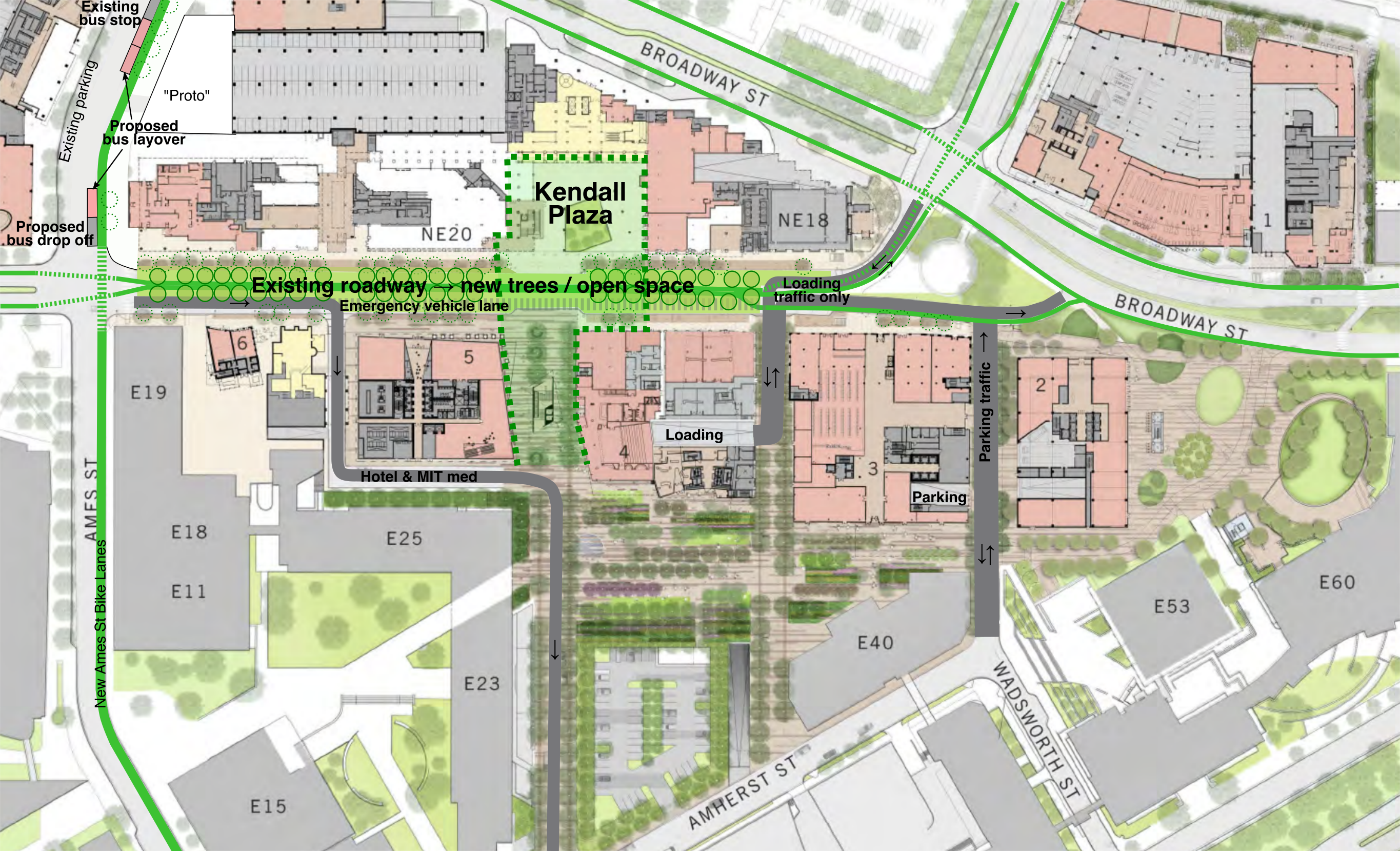
There would still be some asphalt in the square. From the west, a roadway would lead from Main Street to Dock Street, accessing the Kendall Hotel and continuing to MIT Medical. From the east, the planned loading dock in the SOMA project would be accessed from Third Street or Broadway, but this would be a shared street with limited, slow traffic. The parking entrance on Wadsworth Street would exit onto Broadway via Main Street, but the only entrance would be from Wadsworth and Amherst Streets (which would allow exiting traffic as well). Would this make driving somewhat less convenient for some drivers? Sure: someone headed to MIT’s SOMA parking would have to take a right on Ames, a left on Amherst and a left on Wadsworth instead of driving straight through Kendall Square.

This is a small price to pay for the tens of thousands of pedestrians would no longer have to avoid cars in Kendall. Maybe some drivers would take the train instead of driving. In the language of Kendall, this is a feature, not a bug.

It’s Time to Radically Rethink Memorial Drive in Cambridge

Memorial Drive in Cambridge—a pleasure roadway and a park—is actually a death trap. The wide, straight roadway encourages cars to speed, and speed they do, running over a pedestrian several times per year and killing people far too often. The roadway hosts no commercial vehicles, and the eastbound lanes serve only a couple of boating facilities between the BU and Longfellow bridges, yet the roadway—which was designed for low-speed horses and carriages—is built as if it were a highway, and any efforts to improve pedestrian safety have been stonewalled in the name of keeping traffic moving.

Except for a couple of traffic lights and poor-visibility sidewalks, traffic can proceed unimpeded from the BU Bridge to East Cambridge, on a straight, flat, mostly divided highway, where the 35 mph speed limit is honored in the breach. It’s no fun to walk across and only slightly more fun to walk or bike along. Officially, it’s a park, but it doesn’t seem like one.

Memorial Drive is part of the Charles River Basin park and there is a 2002 master plan for the basin. Portions of this plan have been implemented, including the new paths along the Cambridge side of the river, but the roadways have not been touched. (Believe it or not, until the 1990s, parking was allowed on both barrels of Memorial Drive, so there was even more pavement on Mem Drive east and a line of cars along the river.) The plan proposes narrowing the road slightly and moving the eastbound barrel inland from the river, slightly increasing the width of the park along the river. It says that other options were considered, but not advanced further in to the plan. One of these would have eliminated the eastbound roadway entirely, channeling all traffic on to the combined westbound barrel. Apparently removing the roadway would be incongruous with the historic nature of the roadway:

While there is some flexibility in applying
preservation criteria, the historic value of this cultural landscape would
be entirely lost under this alternative.

I call shenanigans. I don’t remember Frederick Law Olmsted planning for two lanes of 40 miles per hour automobile traffic in each direction, and parking. I think the DCR is afraid of reducing the number of lanes on the roadway. Rather than focusing on what the road looks like today, what if the DCR prioritized what would best serve as parkland for the public?

Instead of trying to rebuild the highway-like park (or is it a park-like highway) let’s consider moving traffic to the westbound lanes. Use this roadway for two lanes of traffic, turning lanes at intersections, pedestrian refuges between the lanes to minimize crossing distances and some parking where needed (and charge for it if you can’t figure out how to pay for the roadway changes). At the same and the eastbound lanes can be converted to parkland, increasing green space and allowing us to reclaim the dead space in between the current roadway. It might not match his parkway, but it would create a Cambridge esplanade. I think old Frederick Law would be proud.

There is an 80-foot-wide median between the two barrels of Memorial Drive today, but this is lost parkland, since it is nearly impossible to access and cut off from both MIT and the river, and who really wants to sit in a park in the middle of a highway anyway? If the roadway were consolidated, it the amount of useful parkland would go from 40 feet wide to 145 feet wide. On the MIT side, the portion of the parkland between the road and the sidewalk isn’t even grass, but instead wood chips and mud, since it receives heavy pedestrian use, so the road could actually be pushed north there. This would provide enough room for one lane of traffic in each direction, left turn bays on and off of Memorial Drive where needed, and parking spaces elsewhere. By using part of this space, no trees would be impacted (which would be the case of the roadway were moved south).

But only one lane for cars in each direction? Yes! Memorial Drive in Cambridge carries about 36,000 vehicles per day. While this is high for a single lane in each direction, it is not without precedent, especially for a roadway with few intersections or interruptions. In fact, the DCR has a very similar stretch of roadway with a single lane in each direction which carries the same number of vehicles a few miles west: Nonantum Road, along the river in Brighton and Newton. Most notably, this roadway used to have four lanes but, according to the same master plan, was reduced to two in 2010, yet with turning lanes, traffic throughput has not decreased. The new design allowed room for an expanded bicycle/pedestrian path alongside as well.

These two roadway designs carry the same number of vehicles.

2007:
2018:
The 2002 master plan is dated, but it provides a blueprint for improving Memorial Drive. The DCR and MIT have started to implement some improvements, but these are small steps. It’s time that Cambridge had an esplanade along the river, not a strip of parkland and a wide highway.

It’s time to radically rethink Comm Ave in Brighton

Welcome to the now-series “It’s time to Radically Rethink” where we take a roadway in the Boston area (or, in the future, elsewhere?) and really think about how it could function better. We go beyond a four-to-three conversion, as worthy as they may be, and think about how a 1950s-era street could be reformulated to serve 2020 and beyond. Our first street was Mass Ave north of Harvard Square. Next?

Comm Ave in Brighton.

Why Comm Ave? Because Comm Ave, at least west of Packard’s Corner, is obscenely overbuilt, an eight-lane highway masquerading as a local road. Originally planned as a grand parkway, most of the roadway today is a 150-foot-wide sea of asphalt, interrupted by narrow green islands and the MBTA reservation. The roadway has four through lanes, as well as two frontage roads with parking. If the roadway was used by 60,000 vehicles per day, this might be necessary. But the dirty little secret is that almost no one drives on Comm Ave.

Well, not no one. But very few people. The roadway has between 11,000 and 14,000 vehicles per day, with the higher vehicle counts west of Chestnut Hill Avenue. Some other roadways with similar traffic counts? Washington Street near Saint E’s, Cambridge Street near Inman Square, and Chestnut Street near Jamaica Pond. What do all of these streets have in common? They’re all two lanes wide. (Many two-lane streets are significantly busier.)

Comm Ave is six lanes wide. It’s a complete street for cars—and no one else.

It was originally designed as a Frederick Law Olmsted roadway (a comprehensive early history here), but you wouldn’t know that from the concrete expanse of the roadway today (portions were originally significantly narrower, but was widened in the 1950s). Before the Turnpike, the roadway may have gotten more use, but today it sees little more traffic than a side street. It serves a transportation purpose, but mostly for transit; twice as many people ride the B Line as use the roadway (13,000 people board west of Packards Corner, almost all inbound, so a similar number ride this segment outbound), yet the B line crawls along, stopping frequently for traffic lights and loading passengers on substandard, non-accessible platforms.

Pedestrians are forced on to often-narrow sidewalks, and experience long crossing times (and long gaps between crosswalks) when trying to get from one side to the other. And cyclists? Options for cyclists are to ride in the highway-like traffic lanes or ride the service roads along parked cars with frequent side streets. Despite being the widest street in the city, there are no provisions for cyclists.

So it’s time to radically rethink Comm Ave.

In the City of Boston’s defense, they have gotten a start, but as usual, they are thinking first about cars, and then about everyone else. Their presentation gives three reasons the city wants to maintain four main lanes (six total):

  • Operational flexibility including winter
  • More signal time available for pedestrians
  • Consistent with adjacent segments = safety
Huh? None of this makes sense. First of all, there are plenty of two-lane roads which can be operated in winter (all of them, it turns out). Second, more lanes means more for pedestrians to cross, so this makes no sense. And consistency = safety? How is a wider, faster roadway safer for the majority of users (cyclists, pedestrians and transit users)? If anything, a narrower road would allow for better transitions, and pleasing the wishes of motorists to see a consistent roadway should not get in the way of building something safe for everyone.

Here’s how it comes out:

There’s still a lot of pavement there. Yes, there’s a nice multiuse path, but there are still six lanes of traffic, and parking. And note that since the MBTA does not like trees near their right-of-way, the second-from-left tree would likely not exist. Without moving curbs—as this plan proposes—it’s nearly impossible to rebuild the T stations with full accessibility, nor does it provide a staged plan where, when the Green Line tracks are rebuilt, it can sensibly be integrated with the design.

So what if, instead, all of the current traffic on Comm Ave was shifted to the outside roadways, and the middle of the road became a two-mile-long linear park? In other words, what if you built the portion of Comm Ave west of Packards Corner to more resemble Comm Ave in the Back Bay than, say, the Mass Pike?

This wouldn’t be as hard as it seems, and it could be done in stages with the first stages allowing current traffic movements while providing better cycling and pedestrian facilities In the long term, by rebuilding and relocating the Green Line tracks (a project which the City of Boston should help the T to fund, similar to how other cities fund transit agency projects), it would allow a 75- to 100-foot-wide linear park stretching from Chestnut Hill Avenue to Packards Corner, unlocking the pockets of useless parkland and creating a wide, welcoming park.

Here’s what Comm Ave looks like today:

It’s 200 feet wide from curb to curb, yet two thirds of the spaces is devoted to cars. The two sidewalks take up 37 feet, and the T reservation another 30: beyond that it’s all travel lanes, parking lanes and medians to keep the lanes apart (and encourage faster driving). The city’s plan would mostly replicate this: a couple of improvements here and there, but mostly the same profile.

Here’s an idea of what you could have instead:

This would still allow two lanes of traffic in each direction, but rather than being a pseudo-highway in the middle of the street, cars would instead travel along the edges, and along parallel parking, to allow easy access to local businesses. (A single lane of traffic would only reduce the width of the roadway by a couple of feet, since a certain width is needed for fire apparatus, and would also allow loading zones during the annual Allston Christmas festivities.) Two lanes of traffic in each direction is plenty for this roadway, and this profile provides it. The traffic is all shunted to the side of the roadway and might move a bit more slowly, but this is a local roadway, and slower traffic would be better.

Now, this assumes the MBTA rebuilds its track, allowing a wider roadway on the north (left side of this diagram, which looks east) side. Since that’s a worthy—but longer term—project, there’s a relatively easy interim stage which can be constructed: build the final alignment of the south side (eastbound traffic) of the roadway, and leave a lane of westbound traffic to the south of the MBTA reservation. It would look something like this:

This allows for most of the beneficial elements of the roadway to be built:

  • Most of the green space
  • The curb-side cycletrack on the eastbound lane (which could be shifted to the left if there were data that showed too many turning patterns, although then it is harder to access the sidewalk and businesses)
  • The center walking path and cycling facility
But it’s also very scalable. Once the MBTA right-of-way was moved south in to the existing roadway to allow all westbound traffic to be moved to the north of the T tracks, the rest of the roadway could be filled in allowing for the final state with a wide green median between the two sides of the road.
There’s a lot more to make this street work I’m not showing here (especially on the transit side). The T stations could be rebuilt with center platforms to ease boarding and alighting, moved back from roadways to allow easier operations, fill transit priority allowing trains to proceed at speed through intersections with minor streets (i.e. every street except Harvard Ave), smooth out some of the tighter curves for the Green Line, and place the streetcar tracks in a grassy right-of-way to allow a wide green space in the middle of Comm Ave. Combined, this would speed operations by 10% or more, allowing the T to operate more service with the same number of trains.
But let’s first think a lot harder about how much pavement we actually need on Comm Ave. The city is rejiggering the current alignment. Instead, we could add several acres of parkland to the middle of Allston. We can do better.

A Complete Mass Ave in Cambridge

Cambridge is in the process of starting a citywide master plan (right now it’s in the naming phase). The major thoroughfare in Cambridge is Massachusetts Avenue (Mass Ave for short, of course), and it is pretty much the only street in Cambridge that is more than two lanes each way. Except for a couple of locations, north of Harvard Square Mass Ave is 72 feet wide, and it could be a great street.

Unfortunately, it’s not. It’s basically a highway.

Two wide lanes of traffic each way, parking and a median. Are we in Cambridge, or LA?
All diagrams shown made in Streetmix, which is a fantastic tool for this sort of exercise.

And that needs to change. The street currently serves two functions well: traffic and parking. There’s minimal traffic on Mass Ave because there is ample capacity (the bottlenecks are at either end of Cambridge). There is plenty of parking; nearly the entire stretch of the street has parking on both sides. And since the street is so wide, there is a median to help pedestrians cross, discourage left turns and make the traffic even faster. It is also a concrete waste of six perfectly usable feet.

The street does have 14 feet of pedestrian facilities on either side, but these are hardly enough for the various uses there, which include bus stops, bike racks, sidewalk cafes, building access, power and light poles, etc. And the current lane width is ridiculous. Each side of the street is 33 feet wide: a 7 foot parking lane and two 13 foot travel lanes. Considering that Interstate travel lanes are only 12 feet wide, and 10 foot lanes are used throughout much of Cambridge, this is far, far more width than necessary, meaning that with the median there are 18 wasted feet of space on Mass Ave. Wider lanes cause drivers to speed, which endangers other street users. As for transit, the 77 bus limps along Mass Ave, stuck in traffic and pulling to the curb at every stop, only to wind up stopped at a light behind the cars that passed it.

We need to re-plan Mass Ave, and we need to rethink our priorities. In the 1950s, when the removal of transit safety zones in Mass Ave sped traffic and the end of the streetcars (at the City’s behest, no less), the main priority was vehicular traffic, with no mind paid to cyclists, little to buses, and not much to pedestrians. This is nearly completely backwards. How we should plan is:

  1. Pedestrians. Every street user other than a pass-through driver is a pedestrian. We need to make sure crossings are manageable, sidewalks are wide enough, and traffic is slow enough to be safe.
  2. Transit. Right now there are four bus lines along Mass Ave, the 77, 83, 94 and 96, carrying 13,000 passengers daily (as opposed to 20,000 vehicles). In addition, the street serves as the pull-out route for the 71 and 73 buses, serving 10,000 more. At rush hour, there may be a bus every two or three minutes.
  3. Cyclists. Safe cycling infrastructure is imperative for Mass Ave, as it is the straightest line between Arlington and North Cambridge and Harvard Square and points south and east. It is also the main commercial street for the neighborhood, and safe cycling facilities will allow residents to access businesses without driving. Rather than shunt cyclists to roundabout side streets, we should give them a safe option on Mass Ave. 
  4. Cars. Yes, we need to provide for vehicles. We need a lane in each direction, enough parking to serve businesses (likely on both sides) and turn lanes in a few selected locations. Do we need two lanes in both directions? Certainly not; there are plenty of one-lane roadways which accommodate as much traffic as Mass Ave. And if we build a road that’s better for pedestrians, cyclists and transit users, many of the current drivers will travel by foot, bicycle or bus instead. We also need parking, and there’s enough for parking on each side. It would be eliminated where there are bus stops, but with fewer overall stops there would be only a minor loss of spaces. And with better non-driving amenities, fewer people would drive, anyway.
With that said, here are some Streetmix diagrams of the roadway, and an overhead sketch of how they would mesh together:

This is a typical section of street. The curbs and sidewalks are unchanged, but everything else is. Cars get one lane, plus parking. There are center bus lanes, which also allows cars to pass people parking, or a double-parked car, although this will require enforcement to keep drivers from using the bus lanes for travel or turns. Each lane is 11 feet wide, and emergency vehicles would also use the bus lanes to bypass traffic. On each side of the street, there is a 5 foot bike lane separated from parked cars by a 2 foot buffer (the bike lanes could either be at street or sidewalk level). This would be the baseline configuration of the street.

Now, how do people get on to the bus? A bus stop. Back in the day, this would be called a safety zone, so that passengers could safely wait for and board a streetcar in the center of the street. Mass Ave had these until the ’50s, as did Central Square, as did many other cities. (In fact, they still have them in Philadelphia and San Francisco.) Today, we’d call them part of Bus Rapid Transit. They’d be paired with a crosswalk to allow people to easily access the station, and allow buses to quickly and safely board and discharge passengers without having to pull in and out of traffic. The travel lane would be shifted towards the side of the road in these cases, and the parking would disappear; this chicane would also serve as a traffic calming measure. Of course, there would be no more curbside bus stops taking up parking. This would also reduce the crossing distance of the roadway at bus stops to 47 feet, although less since there would be refuge between the bike lane and the travel lane opposite the bus stop; meaning the longest distance would be only 33 feet.

When a crossing of the roadway is desired away from a bus stop, the parking lanes would be replaced with curb bumpouts beyond the cycle track, meaning that pedestrians would only have to cross four lanes of traffic—44 feet—instead of the current 72. Crosswalk treatments would be included in the cycletrack to warn cyclists of the pedestrian crossing.

A turn lane could be accommodated by reducing parking in a manner similar to a bus stop. This would often be paired with a bus stop opposite the turn lane, with through traffic proceeding straight and the turn lane becoming the bus stop.

What would it look like from above? Something like this:

In the 1950s, we planned Mass Ave for cars. Cambridge can do better. In 2015, we were honored to have built what was described as the best new bicycling facility in the nation. It’s high time we remake Mass Ave, this time for everyone.

It’s time to radically rethink Mass Ave and Beacon St

There’s an intersection in Boston, at the end of the Harvard Bridge, that I bike through all the time.

So do a lot of other people.

Today, one of those people didn’t make it.

Legend:
White: Roadway
Yellow: Exclusive transit
Green: Bicycle
Gray: Pedestrian
Blue: Parking
“Wavy” = barrier or curb

The corner of Mass Ave and Beacon Street is dangerous. Like, really dangerous. It’s relatively narrow in both directions (i.e. not wide enough to easily separate uses), but still wide enough that cars can get up a decent amount of speed. It is heavily traveled by many modes, and has frequent buses and other large vehicles. Some of those things aren’t going away (no, we can’t kick the #1 bus out). We know it’s dangerous; we have for some time. Yet we’ve done nothing about it. Today, that has yielded tragic results.

But there are certainly things we could do. The intersection is dangerous for a variety of reasons:

  • The bike lane disappears so that there can be three (3) lanes on the Boston-bound side.
  • Buses pull in and out of the bike lane to make passenger stops.
  • Bicyclists have no leading signal, so they have to go at the same time as cars.
  • Cyclists accelerate down the grade off the bridge, quickly catching up on turning traffic.
  • Trucks swing out to make wide right turns from the left lane, oblivious to bicycle traffic three, and cyclists don’t see the trucks turning right; trucks then turn across these lanes.
  • There is frequently heavy traffic, so cyclists have to weave between stuck cars. When there’s less traffic, wide lanes allow cars to go fast.
  • Beacon Street has three lanes of traffic east of Mass Ave, making it feel much more like a highway than a city street, despite traffic counts that would barely require two. (It has fewer cars than parallel Comm Ave, which has—wait for it—two lanes of traffic.)
  • There are minimal bicycle facilities on Beacon Street, making cycling there especially dangerous.
As usual, most of the real estate on the street is given over to cars. It was seen as a real coup when Nicole got parking removed on one side of Mass Ave and bike lanes installed in 2012 and, at the time, it was. But we’ve come a long way since then. Comm Ave is getting protected bike lanes. And one of the first protected intersections in the country, which is downright Dutch! We’re fixing bicycling safety issues in other parts of the city: it’s high time we did so at this intersection as well.
There’s another element at play, too, which you can see if you look at the diagram that’s been staring you in the face since you started reading this post: this is a huge transit corridor. With the 1 and CT1 buses, it handles 15,000 bus riders per day, add in the M2 Shuttle and bus passengers account for 20,000 people on Mass Ave, despite lousy service and near-constant gridlock impacting schedules. Given that traffic counts for the bridge are only about 25,000, it means that if you’re crossing the bridge, there’s a better than even chance that you’re on a bike or a bus, as I’ve pointed out before. Yet even with the new lanes (thanks, MassDOT!), we still give 82% of the bridge space to cars, with no priority for transit.
So here’s what you could do:
  • Put a bus lane on the Harvard Bridge, extending south along Mass Ave to Boylston Street (and perhaps beyond). Build a new station at Boylston in the center of the roadway (you’d need left-door buses for this, but these exist), safety-zone type stops like shown here but both adjacent to the Hynes station, or exclusive bus lanes on the sides with signals to allow the buses to move to the center of the roadway. (This could be extended further south as well, but traffic is usually not as bad south of Boylston.) At Beacon Street, install offset bus stations on either side of the street (there’s not room for a single station) with signal priority. Modal equity is a good thing. And despite my feelings about the ITDP’s bus study (this would hardly qualify as gold standard by their rankings with offset stations and lanes demarcated by paint and not concrete, but there’s not room for that), I think this is a great place for bus lanes! And by putting them in the center, you reduce any instances of buses having to cross and block the lanes to make passengers stops.

    This will require removing only a couple of parking spaces on Mass Ave as the busway transitions in to the middle of the street to allow parking on one side. As far as I can tell, the businesses in the area have done fine without parking. Until Boylston, there are two ways of dealing with left turns. One would be to allow left turns from the bus lane, with a green light preceding any bus arrival to clear the lane. Even better would be to ban left turns all together, like San Francisco has on Market Street. This is safer for cyclists, pedestrians and vehicles, and addresses a major congestion issue (while allowing longer phases for straight movements). The few vehicles needing to go left could make a series of three rights (right on Comm/Newbury, right on Charlesgate, right on Marlborough/Comm) instead.

    (Why not at Beacon, too? A northbound driver past Marlborough would have to go all the way to Cambridge to get back. So the left turn lane there fits and allows that movement, although it could be reassessed if it received very little use.)

  • On Mass Ave, the southbound bike lane should be separated to the intersection. This is the most dangerous area, where cyclists are most likely to be right hooked as one was today. Bicyclists should have a separate phase to cross when there will be no other cross traffic allowed. At other times, cyclists could have a red signal for the straight or left (yes, left; more in a second) movement, but a green signal for a right turn on to Beacon Street. In addition, a curb or bollard south of the cycletrack on Beacon would require large trucks turning right to do so with much better visibility for cyclists, which could preclude the need to use specific bicycle signals to keep the users safe.
  • South of Beacon, Mass Ave would be a bike lane without separation to fit in the bus station, but would transition to a parking-protected separated facility.
  • Going northbound, the protected lane would similarly lose its protection at the stop. However, with no right turns possible, there would be no worry of a right hook. It would regain protection across the Harvard Bridge.
  • The Harvard Bridge is currently two five-foot bike lanes and four 11-foot travel lanes. By reducing the travel lanes by one foot each, a two-foot buffer is easily attainable.
  • Now, on to Beacon Street. Beacon Street is easy. It’s currently three 12-foot travel lanes and two six-foot parking lanes. There is no need for three lanes given traffic volumes on the street (just 7500 to 9500 per day!); two would suffice. If you pulled the width back to ten feet, you’d have 16 feet available to add two feet to each parking lane (8 feet instead of 6), a 2 foot buffer and a 10-foot-wide, two-way protected bike lane all the way to the Common. Which is why you’d need the aforementioned left turn from Mass Ave.
This is all doable. The big hurdle is convincing people that cars might have to wait in some more traffic so that transit riders, bicyclists and pedestrians—the majority of the users in the area—can have a faster and safer experience. We’ve seen what happens with the current layout: gridlock, congestion, pollution, with deadly results. It’s high time we made a change.

Update 8/9: In the original diagram, I had near-side bus stops, but it is noted that
far-side bus stops might work better from a transit signal priority point of view, and to allow for larger vehicles to make right turns. This turned out to be the case from a physical point of view as well inasmuch as it doesn’t require the busway to jog nearly as much if the parking moves from one side of Mass Ave to the other. The main issue is that cars would now be aiming right at the “safety zone” style bus stops and an errant car could drive in to a group of waiting passengers, but a protruding island could guide them towards the roadway. (By minimizing the amount of zigging and zagging, it would allow for more parking as well.) Another issue is that this would not accommodate the M2 Shuttle as well, as it turns right on to Beacon Street, but it could continue and go right on Mass Ave or have a separate stop further down Beacon Street. I’ve also added left turn boxes for cyclists. If you’re interested, the original design is shown to the left.

I also have a design shown to the right which has much less transit priority but puts a two-way bikeway in the center of Mass Ave (with enough room for a jersey-style crash barrier on either side). While it would provide a quite-safe bicyclist experience for those going straight, there are a number of significant downsides:

  • Bicyclists turning right would have to cross traffic at an intersection, and could not pull to the curb.
  • It would be very difficult to design a means for cyclists to enter and exit this cycling facility from the Paul Dudley White bike path along the river.
  • Turning movements for cyclists between Beacon and Mass Ave would also be difficult as there would be nowhere for cyclists to wait for a turning phase, which would be required for all turns.
  • Where, inevitably, bike lanes move from the middle to the side it would be an awkward transition (as is the case with the Comm Ave bike lanes at Charlesgate). 
  • The potential for transit improvements are minimal. The main benefit is that there would be no need to transition transit from the middle to the center as would be the case in other scenarios, but buses can more easily signal across mixed traffic. However, transit would only share a lane with right-turning vehicles, and the only way to really improve bus speeds would be to somehow assure that drivers didn’t use the right turn lane to bypass traffic and then attempt to merge back in. Good luck with that.
Update 8/20: Clarified a few things and slightly changed the diagram.