What’s up with the taxi queue at Logan?

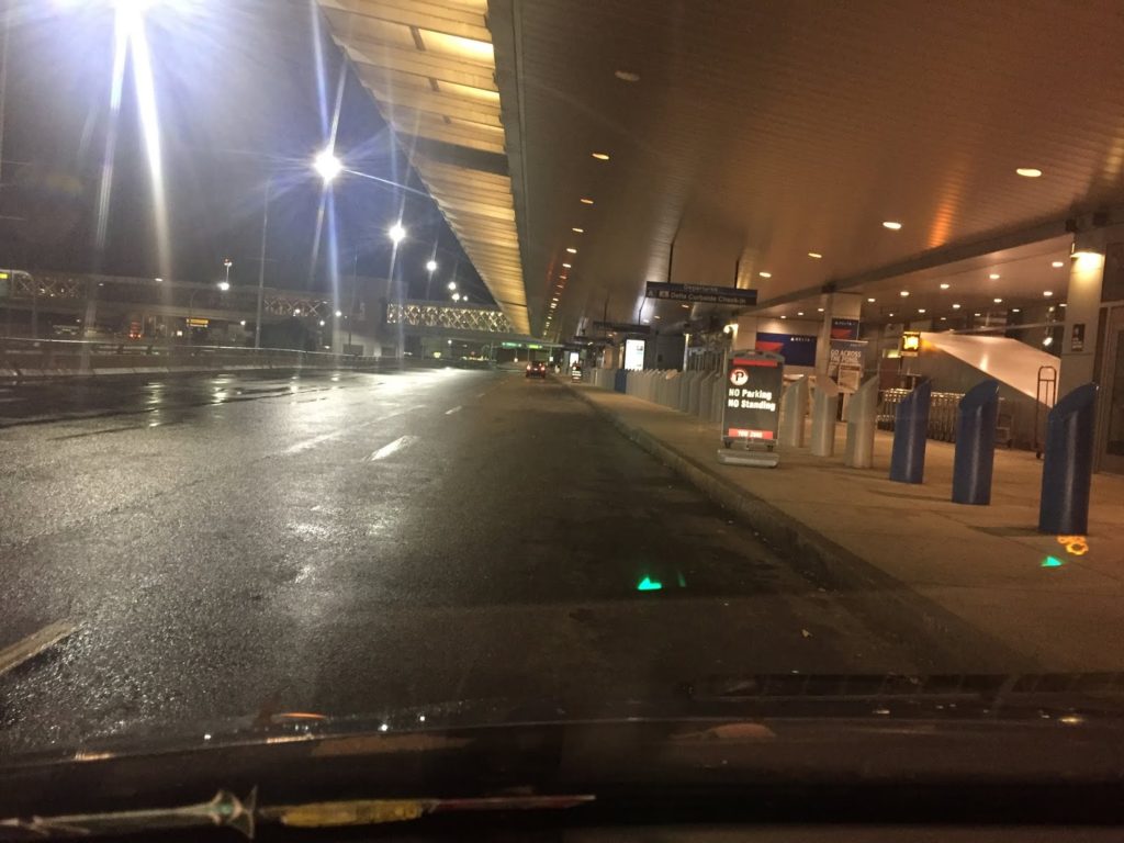
Early Monday morning, on Twitter, Cambridge City Councilor Jan Devereux posted this photo of the taxicab line at Logan Airport:

Then she went to check out the Uber/Lyft line and it was no better:

By 1:30, others reported that the cab line was an hour long.

What’s going on here? Where are all the taxis? Where are all the Ubers? Why are people arriving at the airport after midnight then waiting an hour for a ride home? What can we do about this?

It’s not really a simple answer. Please, though, follow me down a rabbit hole.

Logan airport is not a hub airport (okay, not really: Delta and especially JetBlue are doing their best to create a hub, but it still is mostly an origin-destination airport). This is a matter of geography: because it is tucked away at the northeast corner of the country, the airport mostly handles passengers flying in one direction, south or west, either on direct flights, or to other domestic hubs (although international travel has increased markedly in recent years, and JetBlue even has a bank of later domestic flights to accommodate connecting passengers).

Boston’s flights can be grouped in to three main types: short haul flights to non-hub cities, short-haul flights to hub cities, and long hauls, both domestic and international. Only the first group operates without geographic constraints which dictate that flights can only arrive and depart at certain times of day. Non-hub short-haul flights, mostly on JetBlue and Delta (to places like AUS, BUF, RDU, MKE) are spread more evenly throughout the day, because they don’t have to make connections at hubs. Hub-based flights within the eastern half of the United States (say, as far as MIA, DFW and MSP). These flights account for many of the early departures, but few leave Boston after early evening. They don’t arrive in Boston until mid-morning, but are the bulk of the last flights arriving later in the evening. Because of these travel patterns, Logan has a lot of early and late flights: in the morning, people want to get to a connecting hub for the first “bank” of connecting flights, and in the evening, flights have to leave the connecting hub after the last bank has occurred.

(Not all airlines utilize banking at hubs—Southwest most notably runs continuous hubs—and there are pluses and minuses to each method, about which I won’t go into too much depth here. But basically, banking decreases fleet utilization and increases congestion at hub airports since flights arrive and depart all at the same time, followed, in some cases, by periods of relatively low flight activity, but passengers have much shorter connection times at hubs since connections are coordinated. It’s actually something like a pulse system for buses, except that airports have finite numbers of vehicles which can arrive and depart at any given time, and longer dwell times. As airlines have consolidated, hubs have grown and seen more frequent banks such that they are now closer to continuous operation, especially at large airports like Atlanta and Chicago. See how this is a rabbit hole? Also, when I say people want to connect to the first bank, I mostly mean airlines, no rational human being wants to be on a flight departing at 5:15 a.m.)

Then there are longer-haul flights. Transcons have to deal with time changes, cycle times, and the fact that flights generally don’t depart or arrive between 1 a.m. and 5 a.m. local time. So they arrive from the West Coast either as redeyes between 5 and 10 a.m., and then turn to depart between 6 and noon, or as day flights, arriving in the afternoon or evening. Thus, in addition to the overnight lull, there are basically no transcons which arrive in or depart Boston during the midday. International flights (mostly TATLs) generally are redeye flights going out, leaving Boston in the evening, and return during the middle of the day, arriving in the afternoon. All told, Boston has demand throughout the day, but particularly high demand for flights arriving later in the evening.

For instance, O’Hare and Atlanta, the two busiest airports in the country (by number of aircraft movements), have 29 and 24 flights scheduled to arrive after 11 p.m., respectively. Boston has 39. After 11 p.m., Boston is basically the busiest passenger airport in the country (about tied with LAX), and possibly the world (since in many countries, airports have noise regulations which limit late night flights). Yet at the same time, there are few flights departing Boston. The airport has only 14 scheduled departures after 11 p.m., and only six of these are domestic flights (all are JetBlue E190s, so they’re small planes). There is basically zero demand for passengers to get to the airport late at night. This creates a demand imbalance for ground transportation: there’s a lot of demand to leave the airport at midnight, but almost no one who wants to go there.

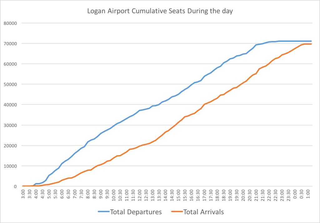
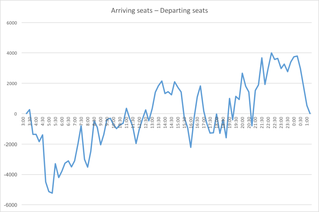
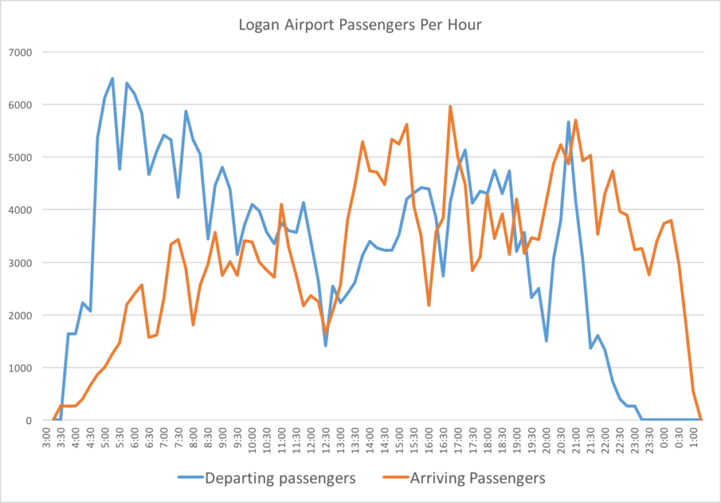
Here are some charts of the approximate number of airline seats arriving and leaving Boston. I adjusted for the typical arrival time at the airport (60 minutes for domestic, 120 for international) and assumed it would take 30 minutes for the average international passenger to clear customs.

(Note, the seat numbers for arrivals and departures don’t exactly match because each day at Logan is not identical and this was a snapshot of a day. This is total seats available, not total passengers, and is also a rough estimate based on plane sizes at different times of day, but should show general trends well.)

So, it’s clear that there is a good deal more demand to get to the airport in the morning, which doesn’t even out until around 9 a.m., various points of imbalance during the day, and then, starting around 7 p.m., significantly more demand to leave the airport.

A couple of personal anecdotes can illustrate this. The first illustrates the imabalce in the morning. Back before the Big Dig was completed (and, in fact, pre-Silver Line, and back when the airport had half the traffic it has today), when I was going to college, getting to the airport was, perhaps, worse than today. It involved both the elevated Central Artery and then the Sumner/Callahan tunnel complex: a trip to or from the airport to downtown could take an hour (which is, of course, not much different than it is now). For several years, however, the Ted Williams Tunnel had been open to commercial vehicles only. The connecting highways were not yet complete, so this was a way to keep the local streets from getting overrun by people trying avoid the congestion.

From Newton, where I grew up, my father came up with a solution, especially for early morning departures. He would drive me to South Station. Rather than risk the airport traffic, I’d get in a cab for the usually $10 or $12 trip under the harbor in the tunnel only cabs could use. Early one morning, I got in a cab at South Station and told the driver I was going to the airport. He quoted the fare: “$20” and didn’t turn on the meter. What I should have done is say “I’ll pay you whatever the meter quotes at the end of the ride, so it’s in your best interest to turn it on now,” but I was 18 and hadn’t quite figured that out, so at the airport, I paid him $20, noted his medallion number, and immediately reported it.

A month later my dad got a check for $20 from the Boston Police (which oversee taxi medallions), along with a note that the taxi driver had been given a stern talking to that he was never to refuse to turn on the meter for a trip within the city.

But I understand why the driver was reticent to take the fare. He would get to the airport and have two (bad) decisions. One would be to go to the taxi pool and wait in line for an fare back to the city: a long line, because there is much less demand going in to the city at 7 a.m. than there are taxis arriving at the airport. The other would be go cross back downtown without a passenger, but still incur the cost of driving, as well as the tunnel toll (which was one-way inbound at that point), with no passenger to pay it. Still, because of redeye arrivals from the West Coast in the morning, there is some traffic for cabs that do make it to the airport going back, although they have to cycle through the cab pool (or the Uber/Lyft pool) before their next fare. Even now, if you take a cab or a ride-hail vehicle to the airport in the morning, the driver is probably not particularly happy taking the fare.

The second example was an extreme example of the late-night issue. I was flying back from SLC and the flight was delayed several hours. Originally scheduled in at 11:30 (plenty of time to catch the Silver Line downtown and take the T home), the plane was more than three hours late, and didn’t arrive in Boston until about 2:30. The airport was empty. Yet a 757 had arrived with 200 passengers, and no one was making the trip at that point to pick us up. So we all converged on the cab stand, but there wasn’t a cab in sight. Immediately, people started self-pooling: it was clear that if we all took our own cabs, the line wouldn’t clear for hours. “Who’s going to Brookline?” “I’m going to JP, that’s close!” “I’m going to Concord.” “I’m going to Lexington, let’s share.” Every few minutes, a stray cab would roll up, three overtired strangers would pile in, and the line would get slightly shorter. I found a cab pretty quickly, but imagine those at the back of the line may have seen the sun rise.

Finally, here’s a picture of the departures level at Terminal A at 8 p.m. this past week.

Delta’s last domestic flight leaves at 7:45 (to MCO) and the last hub-based flight leaves at 6:56 (for ATL). Two international flights leave around 8:30. At this time, it’s a ghost town. Note: if you’re picking someone up at the airport in the evening, plan to meet them on the upper level, and note that Terminal A is a great place to wait without having State Police harass you. (Terminal B was pretty quiet, too.)

Here are scheduled arrivals and departures, by carrier, at different times of day:

Note: not all regional flights appear to be in this sample, for instance, there are no Cape Air flights shown after mid-evening, when Cape Air flies several late flights out of Boston, but these flights are minimal as far as number of arriving passengers is concerned.

Notice how departures peak in the morning, then lull in the midday, and then have a secondary peak in the evening, before domestic departures (except for JetBlue) tail off quickly after 7 p.m. International carrier flights are clustered arriving in the afternoon and leaving in the evening. But there is a clear imbalance for flights arriving and departing the airport.

In any case, this has been a problem for years, and it’s a structural issue pertinent to Logan Airport based on the airport’s geography on both a macro and micro scale. On a macro scale, the geography of the airport at the corner of the country means that, late in the evening, flights feed into it but don’t feed out. On a micro scale, the airport’s geography encourages taxi/app-ride/ride-hail use (I’ll call these taxis, for simplicity). The constrained location means that parking costs are high, because demand for parking outstrips supply. The proximity to areas with high trip generation (downtown, and high density areas nearby) means that taxi costs are often significantly lower than a day’s parking cost ($38) in the garage. The combination of these factors push many people to use taxis.

Much of the day, taxi supply roughly matches demand, and there is a minimal delay for these services. But this breaks down at the beginning and end of the day, especially in the evening. Once again, Logan’s geography comes into play. While the airport is close to the city geographically, it is expensive to get to for a taxi driver. When there is high demand for fares back to the city at 1 a.m.—especially once buses have, for the most part, stopped running—there is negligible demand to get to the airport, or even East Boston in general, so to pick up any fare would require the driver to deadhead to the airport.

Unless a driver happens to pick up a stray fare to East Boston, this requires a driver to travel several miles, and to pay the cost of the tunnel toll. Once at the airport, there is no promise that the trip home will be lucrative enough to cover these costs. They might get a $50 fare to a far-flung suburb. But it might only be a $15 fare to a downtown hotel or, worse, to Revere or Winthrop, meaning a driver would then have to drive back home—likely through the tunnel—and foot the bill for the toll both ways. Moreover, this is the end of the day for most drivers: except on a Friday or Saturday night, there is only so much demand for rides after 1 a.m. For many drivers, the potential upside of getting a decent fare from the airport doesn’t make up for the potential downsides, especially when the alternative is shutting off the app (or taximeter), driving home, and going to bed an hour earlier. There is a high disincentive to be in the last group of taxis at the airport: a driver might get one of the last passengers, but if not, there is not likely a job for several hours when the first redeye flights start to trickle in around 4 a.m. There is little incentive for taxicab drivers to go to the airport during this dwindling time, so demand is only met by drivers already in East Boston who need a fare back to the city.

This is not an easy issue to solve. It also shows why Uber and Lyft are basically just taxis: they are subject to the same supply and demand issues that affect the rest of the market. Alas, they’re providing the same service: a chauffeured ride from Point A to Point B. And the airport is pretty much the only place that cabs still have a foothold, partially because matching passengers to specific vehicles is quite inefficient with large groups, like you might find at an airport. This has been a recent point of contention at LAX, which consolidated its taxi and ride-hail facilities away from the terminals (as Logan is planning). It hasn’t gone particularly well to start, but I would venture to guess that there are similar supply and demand issues at LAX. (As several people have pointed out, the buses there are running much more smoothly, too.)

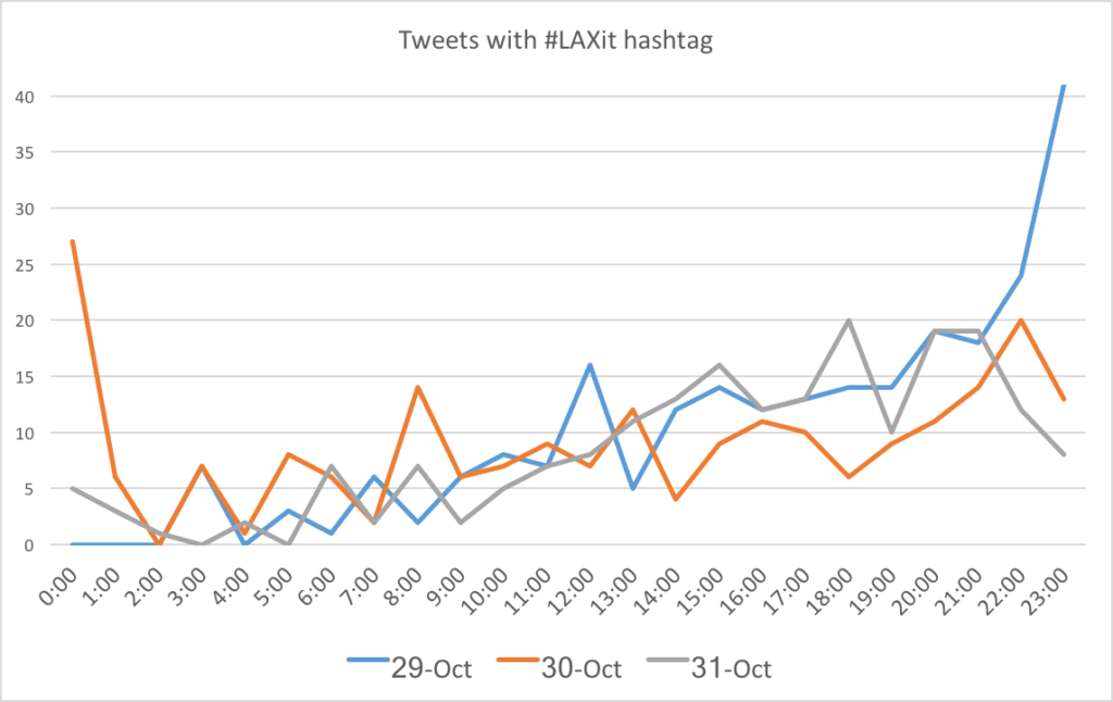
Of course, at LA, there is a temporal aspect to the complaints about #LAXit. Most of the issues are in the evening. Los Angeles has more balanced operations, with plenty of departures in the evening, both redeyes to the East Coast and transcontinentals, mostly TPACs but some TATLs as well. There is probably both more demand for cabs in the evening because LA is on the opposite side of the country as Boston, and also because most of the transcon redeyes leave before 11 p.m., and most of the later flights are international, which are fed more by connecting travelers and by passengers arriving at the airport much earlier. Thus, for the actual demand for taxis, there is a similar, if less pronounced, demand compared with Boston.

I scraped Twitter for #LAXit from the first few days and it seems clear that the issue is mostly in the evening.

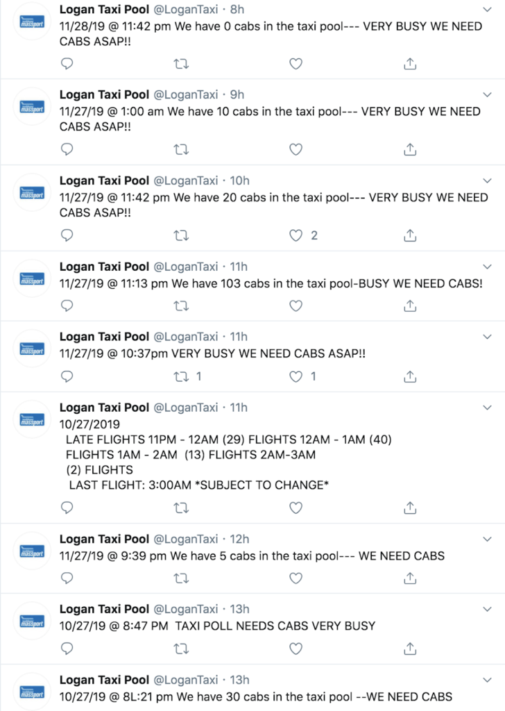
But back to Boston. Here’s what the Logan cab pool Twitter feed (because of course Logan’s taxis have a Twitter feed) looked like last Sunday. There was a cab shortage by 8 p.m., and the late night arrival issue was foreseen by 10 p.m. It wasn’t a surprise. It is a market issue.

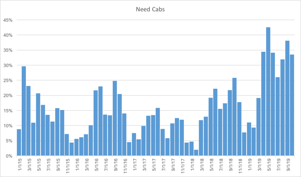
Is this feed a bot? Certainly not! Note the wrong months, typos, misspellings, random numbers of hyphens and use of quotations. The one thing that seems constant is the use of the word “need” when the airport has a cab shortage (with various qualifiers like all-caps or exclamation marks). I’m pretty sure it’s a guy standing by the taxi pool furiously typing tweets into the Twitter machine. So, I decided to scrape the feed (about 60,000 tweets), and code each tweet by whether it included the word “need” or not, to get a very rough estimate of the frequency of taxi delays at Logan.

From the charts of arrivals and departures above, we would assume that the airport would generally need cabs mid-afternoon, as well as in the evening. If we chart the arrival and departure relationship and the Twitter feed’s need for cabs together, and we shift the need for cabs back 1:15 (probably due to actual behavior of arriving passengers), voila, they match pretty darned well.

A few other notes on the need for cabs:

  • There is more demand on Sundays (36% of Tweets include the word “need”), followed by Mondays, Thursdays and Fridays (28%), with the least demand on Saturdays (20%)
  • The cab shortage is generally higher in the summer than the winter (and highest in May, June, September and October, while lowest in December, January and February), and it has been particularly high this year. In fact, the only higher demand for cabs at the airport was in February of 2015. I wonder why.

TL;DR: it is definitely getting harder to get a cab at the airport, especially during certain times of the year and at certain times of day. And when flights are delayed, this is exacerbated. Departing passengers generally still get to the airport on time, but arriving passengers get in later, meaning the cab shortage is even more acute. Which leads to situations like the one which occurred earlier this week at the start of this post, which may have taken you nearly that long to read

So what can be done about it? Well, Uber/Lyft could use their surge features to increase the cost of a trip to the point where it would make economic sense for drivers to come to the airport at this time of day. But that might double or triple the cost of a ride, so while it is a very market-based solution to the problem, it is not consumer-friendly. It (and taxi starters) could do a better job of pooling rides, and moving the Ubers and Lyfts to the same site might make pooling easier there. A very low-tech idea might be to figure out where vehicles are going and, at high-demand times, put people into lines based on regions to help them self-pool. This might nibble around the edges on the demand side, but it doesn’t help supply. It turns out that Lyft and Uber are not a magic panacea to mobility: they are subject to the same supply and demand issues as the rest of the world. And if the answer is pricing, it’s not a great answer, especially since prices might have to go up significantly to provide enough supply or suppress demand enough to satisfy market equilibrium, especially after midnight when there are really no other options available.

One solution, I think, is that rather than trying to bring supply to the demand, we should move the demand to where there is more supply: get people, en masse, downtown. This requires a magical invention: the bus. While the supply of hire cars is not limitless (there are only about 1800 taxicabs in Boston, and probably far fewer are active today, and many more Ubers and Lyfts, but a finite number), it is significantly less constrained on the other side of the Harbor. Instead of trying to entice drivers to come to the airport, we could instead move riders to where are there are more cars. Most riders are going north, west or south of the airport, and need a ride through Downtown Boston anyway. The bus might not be that appealing to a traveler at 1 a.m., but neither is a 45 minute wait for a cab. This basically takes what LA is doing, and extends it a couple of miles.

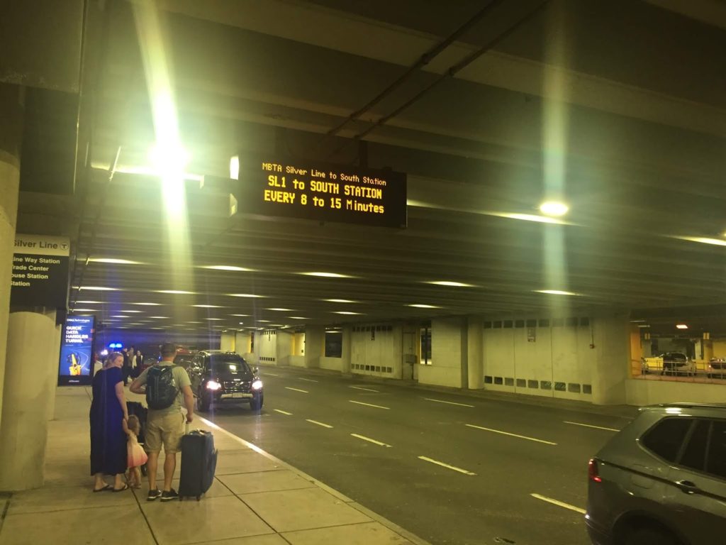
The MBTA runs the Silver Line until 1:15 a.m., which could easily bring passengers to South Station, where catching a taxi or ride hail vehicle is easier than at the airport. Massport and the T, however, do a poor job of advertising these late buses, both with signage telling passengers the hours as well as real-time information about the buses’ whereabouts (important especially if you are unsure if the last bus has left). But these are easy issues to solve. The bus real-time data is available: I have no issue pulling it up on mbtainfo.com, for instance.

Not helpful, especially if you’re trying to figure out if the last bus has left, or even deciding if it’s worth waiting in a cab line versus waiting for the bus.

And Massport could put up static signage:

NO CABS? NO PROBLEM!
GET A CAB ACROSS THE HARBOR
MBTA BUS TO SOUTH STATION
SKIP THE LINE — SAVE MONEY
BUSES EVERY 8-15 MIN UNTIL 1:15 AM
ADDITIONAL BUS AT 2:30 AM

And as I’ve written before, with some minor schedule tweaks, the T could use the Silver Line 3 returns from Chelsea to supplement this service even later, and keep one bus in service to make an extra round trip to provide service until 2:30 when, on most nights, the planes have all landed. Alternatively, or in addition, Massport could continue its Back Bay Logan Express bus later in the evening and into the early morning (or even 24/7), providing late night trips to the taxicab-rich parts of Boston when there are cab shortages at the airport (and perhaps even direct service to large hotels in the Back Bay).

Even more, the Logan Taxi Twitter feed often includes this kind of Tweet:

By 10:00 most evenings, someone at Logan knows how many late flights are coming in. So, conceivably, the bus driver could be held on duty to make extra trips in the cases of delays. Massport, which already helps to subsidize the fares for the Silver Line, could shoulder the rather minimal cost of the extra trips. And passengers arriving at midnight would no longer have to face an hour-long wait for a cab, when there are many more options across the harbor.

The market has never provided enough cabs at Logan when they are needed, and at certain times of day, lines of cabs are the rule, not the exception. Assuming the market will take care of this has never worked, and it is unlikely that it ever will. If Massport worked with the MBTA, however, it could pilot a project to move people downtown and create a secondary taxi queue there, where drivers would be much more willing to go for a fare, because even if the demand had dried up, they wouldn’t be out the tunnel tolls, mileage and time to show up at the airport.

How much does BRT cost? 7X less than LRT? (Hint: No.)

This is the third in a series about the ITDP bus rapid transit report for Boston, and the ITDP standard in general.

One of the claims often made by BRT propagandists is that constructing bus rapid transit is seven times cheaper than light rail transit.

This is from the executive summary of the ITDP’s Boston BRT report:

Analysis of recent transit development costs
in the United States suggests that implementing BRT in these
corridors would also be more cost-effective than other options
for improving the existing transportation system. Based on this
evidence, on average, BRT can be seven times more affordable
per mile implemented than light rail.

Their “Benefits of BRT” page repeats this factoid several times. Quite a ways down the page do they use some properly weasely language to qualify their statement: “BRT can on average be up to seven times more affordable than light rail.” (Italics mine.) Hey, guys? That’s now how averages work. An average is the sum of a set of numbers, divided by the total number in the set. It’s like saying “In February, Boston gets, on average, up to 65 inches of snow.” Boston must be a snowy place, a reader would say, since some there must be a lot of years that have more snow than that. Except “up to” denotes an outlier. Boston normally gets, in average, about 12 inches of snow in February. 65 inches is an outlier. The ITDP report is off by about the same factor.

If this seven-times-as-expensive figure were the case—especially in corridors where demand is not likely to exceed 2500 passengers per hour—then it would make a lot of sense to build, right? If you can get 25 miles of BRT for the price of four miles of light rail, it’s a no-brainer. But what about if you can get nine miles of BRT for the price of four miles of light rail? Because that’s the actual ratio: light rail comes in at slightly more than twice the cost. And the while the ITDP bandies about that number, they cite no actual evidence to back it up.

Given the capacity constraints of bus rapid transit, it becomes a harder choice: if you spend half the cost of light rail on a bus system that doesn’t have the capacity to serve the needs of the corridor, it’s wasted money. It becomes a sort of Yogi Berra white elephant: no one goes there anymore, it’s too crowded. Crowds seem like success, and they are, to a point. But overcrowded transit runs more slowly and is more prone to uneven headways. In other words, if you build it, and they come, then what?

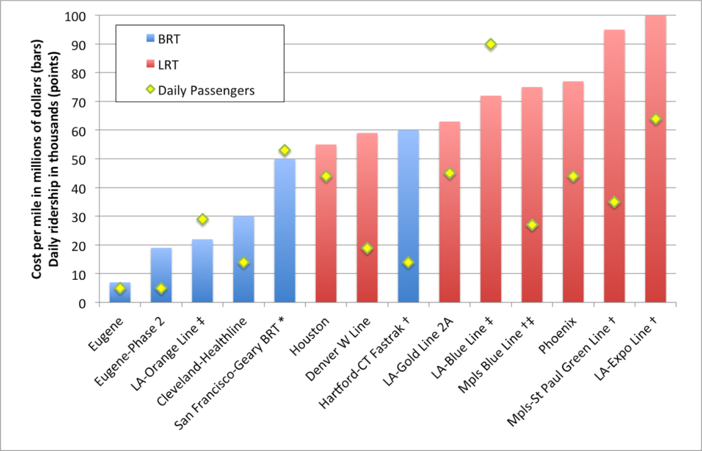
* Planned for ~2020. Ridership includes 38, 38R, 38AX, 38BX
† Included significant grade separation/bridges/tunneling
‡ Primarily in an existing right-of-way
All dollar figures adjusted for inflation (2015)

I like charts (you’ll know that if you’re a frequent reader) and here is one. It shows the costs per mile, and daily ridership, for a variety of BRT and LRT projects which have been built recently. I included several Los Angeles LRT examples because it is the only city which has built both BRT (to the level of an ITDP standard) and LRT in that time, and included the much older (relatively) Blue Line because it was mostly built on an old Pacific Electric right-of-way, much like the BRT Orange Line. Is light rail more expensive to construct than bus rapid transit? Yes. Is it seven times more expensive? Certainly not. The distance-weighted average construction cost for light rail is about 225% higher than BRT, less than a third of the difference that the ITDP suggests. (I’ve left out rail examples here—the Central Link in Seattle, for example—which include significant tunneling or grade separation, and similar BRT systems.)

There is only one example of BRT construction which is seven times less expensive than any similar light rail line: the Emerald Express in Eugene, Oregon.

Eugene, Oregon The Emerald Express was cheap to build: but you get what you pay for. The line serves a transit system which has a daily ridership of 40,000; fewer than most of the light rail lines above. It runs every ten minutes—frequent by the standards of a small town—but will require significant more investment to go any faster. Why? Because many of its exclusive lanes are bidirectional: a bus may have to wait for a vehicle going the other way to clear. It’s like a single-track railroad with passing loops for buses. And the stations are not what you’d see in Bogota: here is one along a less populated stretch of the route. This is not to say that there’s anything wrong with the Emerald Express—it is good for the community it serves. But that type of infrastructure would be overwhelmed on opening day in Boston.

Oh, also: the second leg of the Emerald Express—with similar BRT features—is coming in a bit higher: $19 million per mile. So the one-seventh number? It’s pretty selective.

Los Angeles Then there’s the Orange Line in LA. It is certainly successful, relative to an unused corridor, anyway. It runs every four minutes and carries 30,000 passengers per day. It’s basically at capacity. It cost $27 million per mile to build initially (but the recent extension was more than $50 million per mile), and has a third the capacity of the Blue Line, built in a similar corridor. It wasn’t built as light rail because, well, it’s along story that includes Orthodox Jews and corrupt politicians. You can’t make this up. Since it’s over capacity, there are initial plans to improve capacity (costing another $20 million per mile) or convert it to rail ($65 to $95 per mile).

The cost for a bus line that will perform anywhere near the level of a rail line will wind up being just about as high, and will still have a much lower capacity—certainly nowhere near the 90,000 passengers the Blue Line carries. Of course, there’s a sunk cost issue. Having already spent $600 million on a busway, there’s an argument not to “throw this money away”. But the total cost for the busway could come to $1 billion by the time all is said and done, about what light rail would have cost in the first place, with a lower overall capacity. So the BRT is really a white elephant, even if it’s one that transports a lot of people. This is a perfect illustration of the problem I posited above: you spend a lot of money on a project and quickly it is overburdened.

Cleveland Perhaps the best example of a successful BRT line in the US is the HealthLine. It was built along six miles of Euclid Avenue from downtown east towards a university/hospital cluster (including, yes, the eponymous Cleveland Clinic, and Case Western, too). It carries about 14,000 passengers per day, and does so in a well-designed corridor (the only one in the US to qualify as Silver based on the ITDP’s standards). The corridor varies between about 70 and 90 feed wide. The cost? $30 million per mile. It was probably a good investment. There is a roughly parallel heavy rail line that makes the end-to-end trip faster, so there’s never likely to be very heavy corridor ridership, and it likely won’t have to scale beyond it’s single-lane capacity. Of course, this rail line has plenty of capacity (it is by far most lightly used metro system in the country) between the HealthLine’s endpoints, so there is a valid question as to whether these investments were necessary.

BRT boosters (ITDP) point out that the HealthLine has been the $5.8 billion of development which has taken place along the line. (Well, other sources put the number in the $4 billion range; it’s a big number.) Which is great. But two important caveats. First: correlation does not imply causation. Much of this development was planned out well before the line was built. Much of it likely would have taken place if no improvements had been made. It’s not like the Cleveland Clinic (with 1500 beds and $9 billion in annual revenue) waited for the bus line out front to be built. Or that Case Western—with a $2 billion endowment—didn’t spend any of it until the HealthLine was completed.

The comments by Coolebra in this article flesh this out very well, as does this article. As one commenter there quips:

I could probably go put a giraffe near the Cleveland Clinic, and surely the Clinic will build another building within the next 24 months (or two). I can publish a study showing that giraffe investment is the best way spur development as cities run around to put giraffes across their neighborhoods.

The point being: there are a variety of factors which account for the return on investment for any transit line. Crediting all of it to a single source is folly. And let’s all say it together: correlation does not imply causation!

Second: most of the improvements have taken place on the eastern end of the line. This happens to be where it mostly parallels the aforementioned Red Line rail line. Saying that all of the development in the area occurred because of the HealthLine would be like ascribing all of the development between Dudley Square and the Financial District in Boston to the Silver Line. It helps, but there are a couple other factors—and rail lines—involved.

So there’s nothing wrong with the HealthLine, per se. It is a decent investment and has room to grow. But there needs to be a bit more nuance in analyzing it’s ability to leverage private investment than claiming that anything built within a stone’s throw—a college campus and two major hospitals—is only there because of the BRT. (In fact, they’re there because of transit—originally, Euclid Avenue had a streetcar, of course.)

Hartford Very recently-opened is CTFastrak in between Hartford and New Britain. Like the HealthLine, it probably doesn’t have the capacity needs for a rail line, and there’s no existing light rail infrastructure in Hartford to build upon. It’s reasonably fast, mostly grade-separated, and serves both buses along the line and others that enter the line part way along it. (It’s brand new, but has been getting good reviews.) Of course, it cost $60 million per mile to build, which is comparable to most new light rail lines. It will probably score well when the ITDP comes to town (separate platforms, some passing lanes, etc) and they’ll probably gloss over the fact that it cost as much as a couple of sets of railroad tracks.

It might be a good time to point out another hidden BRT cost: maintenance facilities. Light rail costs almost always include the operating fleet as well as the cost of maintenance facilities. Most BRT systems makes use of existing maintenance infrastructure, at least to start, which reduces costs in the short run but in the long run will require more or larger garages to be built down the road, especially if the line is successful (the cost of the vehicles is usually included in the cost of the system). I don’t believe BRT costs have future maintenance facility requirements amortized in to their figures. Since these are likely shared with other bus operations, the costs won’t be factored in to the cost of the system. Such facilities can cost more than half a million dollars per bus, adding a million dollars per mile in costs for frequent systems.

San Francisco And then there’s Geary, one of the busiest bus lines in the country. It has more than 50,000 daily passengers spread out among four routes, the 38, the 38R (a limited stop route) and two rush-hour express routes, the 38AX and 38BX, which serve an outer portion of the line before using other streets to access downtown San Francisco. In a sense, these already function as a local-express BRT network, just without the bus lanes, stations and other amenities the ITDP looks for. So basically BRT, without the R. Do they function well? Hard to say. People seem to like the limited and express options (I mapped their Yelp scores a few years back) although at rush hour the 38R, which comes every four minutes, is at or near capacity (running 60 foot buses).

The city is planning to build BRT and have it “light rail ready” because they don’t have the money for light rail. The problem is that this is going to have the capacity issues that the Orange Line has in Los Angeles on day one. Yes, better platforms, signal priority and wider doors may help, but the system already carries more than 3,000 passengers per hour, so it won’t have the capacity in a two lane system. Much of it is being built as side lanes instead of in a center median, especially in the inner part of the route, so limited buses will be able to pass locals in mixed traffic lanes. But it won’t really solve the capacity crunch, especially if there’s traffic in those lanes.

There are two ways to add enough capacity on Geary. One would be to build light rail. A three-car light rail train every five minutes would carry 6000 people per hour and not be at capacity. The second would be to build a full-on four-lane Bogotá-style BRT system. The corridor already has local, limited and express buses: at rush hour, there are nearly 60 buses per hour serving the corridor. This would allow buses with different service patterns to skip stops easily, and as we’ve said before, a multi-lane system does have capacity that will match light rail.

There are only two issues. The first is that even the half-baked BRT system will cost $50 million per mile (and run in to the same white elephant/sunk cost issue as LA has). A four-lane system would likely cost more, getting in to the range of the average light rail system. The second is that while there is enough space on the street for this type of system, there’s not much to spare. Geary is about 100 feet wide—one of the widest streets in San Francisco—but it is still narrow compared to most streets in Bogotá. Since most highways in the City were never built (or removed) and these few rider surface streets, it functions as a thoroughfare, as well as a shopping street. So to take four lanes plus stops for a busway would leave only 35 feet or so on each side, barely enough for one lane and parking. This likely wouldn’t fly, so you get single-lane BRT: pretty expensive, but minimal improvement to capacity. The B-Geary was one of the last lines in San Francisco to lose streetcar service, and the only way to keep enough of the road for cars and have enough transit throughput is a light rail line, even if it would cost more. BRT is, to quote Sarah Palin, lipstick on a pig.

Minneapolis-Saint Paul There are several light rail lines which have been built as well; for some of them there was a conscious choice made between bus and rail transit. The Green Line between Minneapolis and Saint Paul is one. When it was proposed, bus rapid transit would have cost about a third of the cost of rail. But it’s unlikely that it would have been able to handle the passenger loads that the rail line carries, especially since it serves both the University of Minnesota (with 50,000 students, one of the largest in the country) and both downtown Minneapolis and Saint Paul (Minneapolis being the larger traffic generator). The line already carries 35,000 passengers daily—more than the ten-year-old Blue Line (which was built along an already-cleared but never-built freeway right-of-way)—a year in to service. With those riders, Minneapolis now has the highest ridership of any light rail system opened since 2000.

It also serves the Cities’ main sporting arenas (the ballpark, hockey, basketball and both football stadiums and the minor league ballpark; and yes, the Twin Cities may be the most over-stadiumed city in the country), so in addition to heavy loads at rush hours, it has to cope with frequent event traffic as well. If it were a bus rapid transit system, it would have been overloaded from the start. As a light rail line, it can cope with demand with 10 minute headways at all times (except overnight, and, yes, it runs 24 hours a day), which means it could easily double capacity—or more—if ridership increases.

Which is not to say that the Twin Cities don’t have any bus rapid transit. They have a couple of freeway-based lines (which don’t really conform to ITDP standards) and are planning several arterial lines, which may not have exclusive lanes but will have better stops, all-door boarding and more frequent service. One, on Snelling Avenue, intersects the light rail lines near both lines’ midpoints. While Snelling once had a streetcar, it probably wouldn’t merit one today, but it connects the two rail lines and will provide an important link in the region.

While the Twin Cities may be somewhat light rail-heavy in their planning, they are choosing appropriate modes for each corridor. They aren’t hamstringing heavily-used routes with inadequate BRT because it’s cheaper (or because buses are always better, or something) but aren’t spending on light rail where BRT will do the trick (the streetcar plans are another story, and how I feel about them—conflicted—is the topic of another post entirely). Rail cost more than twice as much as BRT would have (but certainly not seven times as much) on University Avenue. But it provides more utility than BRT on day one, with room to grow. It was a smart investment, and the right choice.

I’m more familiar with the Twin Cities than other regions, but imagine there are others which act similarly. But the ITDP wouldn’t give them the time of day and certainly doesn’t examine rail systems as “gold standard” or otherwise. Perhaps it’s time we took a more holistic approach towards analyzing transit investments—looking at ridership, throughput and actual costs, not hyperbole—rather than engaging in mode wars (the Transport Politic made just this point recently). Let’s choose the right mode for each corridor, not blindly push for one over another based on preconceived agendas.

When Multiple Agencies Attack … a NYT Reporter

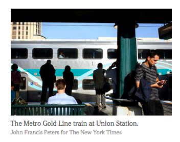
The New York Times ran an article this week wherein a reported attempted to navigate Los Angeles by transit. There’s an obvious faux pas in a picture caption (see right, and see if you can figure out what it might be), but otherwise the piece is a list of trials, tribulations and eventual successes trying to navigate Los Angeles by something other than a car.

Sometimes successfully.

As someone who once navigated LA for a week mostly by transit—aided by an iPhone and, at times, a friend at USC—I can empathize with Mr. Hanc to a degree: it can be hard to figure out how to use the system. And while I would criticize some of his convoluted routes and relying on infrequent direct buses when there were better options (and, yes, I’ll try to reconstruct his journeys later), another glaring issue is the multi-agency mishmash, especially in the part of LA where many of his travels took him: the area between Westwood, LAX and downtown.

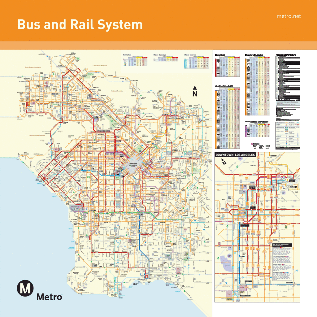
First, Metro’s system is huge. The LACMTA carries more than a million passengers a day; only New York carries more. Since New York has the bus system separated out by borough, it’s probably the most complex system map in the US. Seriously, check it out:

Good luck making sense of that! But to add insult to injury, there are no fewer than 47 (forty-seven!) municipal bus operators. LA Metro has a long history of interagency squabbles—it was created in 1993 after two separate operators were merged because they almost built two subway lines that didn’t connect. And while, as far as I can tell as an outsider, there is not much contention right now, there are certainly still multiple agencies running multiple—and sometimes parallel—services, without fare or schedule integration.

It makes it tough, especially as an outsider, to use the system. When I was there, without time constraints, I stuck to Metro services (and a trip on Metrolink, the region-wide commuter rail service) even when another trip might have been better. I had a 7-day pass, and didn’t want to bother with learning the transfer purchase system. So I stayed away from Dash, and the Culver CityBus, and the Big Blue Bus, and others. But in the area that the Times author was traveling, he had too many choices, which led to enough confusion that he wound up taking at least one trip by car, and convoluted routings on others.

There’s obviously a lot of history and issues of local control, but from an outsider, it makes the whole system—which is complex enough already!—a pain to use. I know if, for instance, I’m in Chicago, and I want to go to a suburb, I might wind up on Metra and a Pace bus. Or that in New York I might need to take NJT or a Bee Line Bus or a bus out on Long Island. But to go from LA to Santa Monica is like going from Manhattan to Brooklyn, or the Near North to Wicker Park. Even in San Francisco, home to dozens of local agencies (many of them large—AC Transit is the tenth largest bus system in the country) the boundaries are generally clear: Muni in the city, AC across the bay, SamTrans south, Golden Gate north, VTA in San Jose.

In LA, all bets are off. It means that local riders may be penalized for crossing a city line; at least in San Francisco, the systems are county-run, and the dense cities (San Francisco and Oakland) only really have one system to use. Anyone unfamiliar with transit—whether a car-driving local or a visitor—will be flummoxed, as the author was:

But when I got to Westwood, I was dumbfounded. Buses of every size and color whizzed by: big blue City of Santa Monica buses, green Culver City buses, blue and white U.C.L.A. “Bruin Bus” shuttles. A barista at a nearby Starbucks pointed me to the one I wanted: the Metro Rapid 734 bus.

If you’re LA, and your reputation is already that it’s hard to navigate by transit, extra barriers to entry don’t help. The LACMTA is actually a pretty good system, buses are frequent, well-marked, go most everywhere, and once you learn the difference between an orange local bus and a red “Rapid” bus, as well as the fares (no transfers, cheap day passes) and a few other eccentricities, it’s easy (if not always speedy) to use. That is, unless you wind up going somewhere served by another agency. Then it’s almost as if you’ve flown to another city, even if you’re a mile away.

So, to recreate John Hanc’s journey, using GTFS, which has most transit agencies in it (and which I think he could have been helped by):

His first trip was from LAX to an unnamed hotel that overlooked the 405 he had to take the 734 on Westwood to get to. The 734 crosses the 405 on Sunset before going over the Sepulveda; it’s likely that it he was staying at one of the hotels at or near Sunset and Sepulveda. While he chose the airport bus to Westwood, a more frequent and less confusing option would have been the Culver CityBus 6 or 6R to Westwood ($1 fare instead of $10) from the airport bus transit center, and then a change to the 734. That bus would have dropped him on Westwood, not a few blocks away, for an easier transfer. Still, it’s multi-agency, so it’s not simple. And you have to get to the first bus on an airport shuttle, too.

The next morning he went from his hotel to the Hammer museum. He got a ride, even though it would be an easy, one-seat ride on the 734, every 20 minutes or so.

Next, he needs to take an afternoon trip from UCLA to downtown LA. This should be pretty easy, if not super fast. His buddy Mark works right downtown, near the terminus of all the buses and near the actual subway. Somehow Hanc finds a commuter bus that runs less frequently (four times a day!), and trades frequency for speed—and winds up waiting an hour for it. There’s a LA Metro route 534 from Culver City to Malibu, but it’s not the route he’s looking for: he wants a LA DOT 534, which is a different service entirely, although the fare media are at least integrated. Here, it pays to learn that any time you might make up waiting for an infrequent service you could spend already moving towards your destination, albeit slowly.

But it’s another illustration of how convoluted the overlapping systems are. You can take the LA DOT 534, or you can take Metro 720 to the Red/Purple Line, both of which will get you downtown in about 1:00, and which run parallel to each other. But there’s no fare or schedule integration. Maybe it makes sense for a daily commuter. Maybe. But for an outsider? Forget about it. It should be noted that if and when the Purple Line Extension a.k.a. Subway to the Sea (although it won’t quite get there) is completed, it will be a one-seat subway ride from Westwood to downtown, rendering the current alphabet soup for that ride moot. This might be done in 20 years.

Did he have to even go downtown? He could have taken an express bus due north and met Mark in Valley Glen, saving Mark the drive out of the way to pick him up, and himself the long wait for the bus. Since LA has no real center, it’s generally possible to get from one place to another without going downtown. (Although maybe he and Mark had dinner downtown; he doesn’t say.)

The next day he takes a BRT Line to a Subway. Easy. (Apparently Mark prefers to sit in traffic even though he lives walking distance from the Orange Line.) Then he was taking the Antelope Valley Line out to Newhall and coming back to Burbank, before transferring one stop outbound to the Burbank airport. He could have taken the 164 to Burbank, and then gone outbound on Metrolink from there. That would have also meant he would have bought a ticket from a machine rather than a person (and, yes, it’s perfectly fine to buy a ticket between non-downtown locations). And on the way back, rather than backtracking to Burbank and switching trains, he could have, again, taken a train to a bus.

So kudos to John Harc for sorta kinda getting around LA by transit. If only he’d actually planned ahead a little more, he could have saved a lot of time. And a couple of rides with Mark.

How many buses on Wilshire?

Another bit about Los Angeles: while there, we decided to take the bus on Wilshire towards Santa Monica. In doing so, we boarded one of the most frequent bus routes in the country. How frequent? At certain times of day, three dozen buses run along Wilshire Boulevard per hour, one every 100 seconds. They’re split between the local 20 bus (headways of 6-12 minutes; 30 minutes overnight) and the Metro Rapid 720 bus (headways of 2-9 minutes, generally less than 5). Yes, two minutes. From 6:30 a.m. to 8:30 a.m. westbound, the 720 has an astounding 51 trips, with buses arriving every 2:20 on average (not counting the 20, which adds another 20 trips.

The 720 is operated with 60-foot buses which have a capacity of 100 passengers; or 2500 per hour, with an additional 600 capacity on the 40-foot 20 buses. 3100 passengers per hour—more than a freeway lane of traffic. Yet this parade of buses has operated in regular traffic lanes, with only limited abilities to hold traffic lights. That’s slated to change, as rush-hour bus-only lanes have been approved for most of the corridor. The changes, which will cost $30m, are slated to save riders 10 minutes per trip. While it’s not the ideal solution (that would be a decades-long plan to build a “Subway to the Sea” under the corridor, which would serve many more people and halve transit times), it is a relatively inexpensive fix which will help thousands of riders a day.

How “relatively inexpensive” is it? There are approximately 160 affected trips daily (buses don’t run in each direction at the same frequencies), and we can assume that these trips are 75% full at rush hour (75 passengers per trip). That equals savings for 12,000 passengers per day, times 10 minutes, or 2000 hours saved per weekday, or 500,000 hours saved per year. There is limited literature regarding travel time costs (how much people value the time they spend in transit) but a conservative estimate is $8 per hour; about half of the prevailing average wage. (It’s possible that mobile computing will raise this considerably.) In any case, 500,000 hours at $8 per hour is equal to $4m per year, giving the project an eight year payback in this metric alone.

Of course, LACMTA stands to save as well. Saving ten minutes per trip will save the agency 1600 minutes of bus operation per day, or about 27 hours. It costs about $100 to operate a bus per hour, equating to a savings of $2700 per day, or $675,000 per year (and these are much more quantifiable savings than the time costs).

Will bus lanes give Wilshire Boulevard an acceptable level of transit? No—with the ridership the corridor sees a grade-separated line is probably necessary. But since that is many years off, this is a step in the right direction.

Los Angeles: where’s the transfer?

This spring, I spent some time in Los Angeles—and most of the time I was there I spent without a car. I’d called off a planned hike of the Pacific Crest Trail and stayed with family and friends for most of a week (with an interlude to take the train out to the Grand Canyon) and explore Los Angeles, mostly by bus.

Los Angeles is, of course, synonymous with the freeway and the car. (And, of course, traffic.) While there is a coherent-and-growing network of commuter rail lines, they serve a small proportion of transit use. The rail network—a few light- and heavy-rail urban lines—see more use. However, the majority of Angelinos traveling by transit do so by bus. Of the 1.4 million daily riders, about three quarters—well more than a million—ride the bus, making it the second largest bus system in the country.

There’s been a bit of news about the agency, too—namely, a New York Times article regarding the 305 bus route, which mostly ferries domestic staff from poorer neighborhoods south of downtown LA to wealthy suburbs to the city’s west. The route is slated to be discontinued as the newest light rail line, the Expo Line, will open this fall. When fully completed, the Expo Line will allow for much faster east-west service from Downtown Los Angeles to Santa Monica, a route which is currently heavily traveled and quite slow. And, as with most new transit lines, local bus service will change based on its opening.

In 2004, when I was but a budding student, the Hiawatha Line opened in Minneapolis from downtown to the airport. In Saint Paul, we’d had direct service on the 84 bus (2004 schedule pdf) line every half hour from our college campus to the airport. After the light rail opened, the buses were dramatically rerouted and the trip requires a transfer to the light rail, adding a bit of time but increasing options to get to the airport; the thrice-hourly 74 bus routes near the campus as well. In fact, the 84 was just about the only route whose airport service declined in service. Most buses now have faster and/or more frequent airport service.

And, thanks to free transfers, the fare remained the same. (It’s since risen, but there’s no surcharge to ride the train.)

This is a major problem in Los Angeles. There are no free transfers. If your destination happens to be on the same line as your starting point, the fare is $1.50. If it’s at a right angle and you have to change, it’s $3.00. Given the size of the LA area, it’s quite possible to take a three-legged trip (say, east, north, and east) and pay $4.50. These fares are made up to some degree with the availability of a $6 daily unlimited fare (made up for by a round-trip with transfers). Still, the tacit discrimination against people with trips that don’t fall on a straight line is unwarranted.

And this is the biggest issue with the 305 bus story. If you put the trip from one end of the 305 route to the other on Google Maps, say, from Watts to Cedars Sinai (I picked these simply because they were easily identifiable landmarks near each end of the 305) the map output shows several options:

  • 1:18: Take the Blue Line to the Green Line to 550 express bus. 
  • 1:16: Take the Blue Line to the Red Line to the 14/37 bus.
  • 1:17: Take the 305.

Three very different routes, all with travel times within two minutes. The 305, following Los Angeles’s grid of streets, travels the same distance, but since it is on surface streets the whole way, it travels quite slowly. The rail lines attain much faster speeds which make up for the multiple transfers. (And many other destinations along the 305 benefit from the Metro Rapid system—limited buses which run frequently and only stop every half mile. They’re not that fast, but certainly speedier than buses which stop every block of miles-long routes.) The Times, which states in the lede that “It will be more than an hour before they arrive at work, and soon the same journey may stretch to nearly two hours” supports its narrative with a falsification. It goes on to use the fear of the unknown (in this case, transferring) to posit an actual detriment to service, which it is not.

Then, there’s frequency! Human Transit makes exactly that point: the 305 only runs once every 45 to 60 minutes, while the other services run every five or ten. So if the 305 happens to be about to run (and, yes, LA is on NextBus) it’s faster to travel by other routes. These services—plus the Expo Line—should be able to absorb the 3,000 daily travelers on the 305 without any effect. It seems very reminiscent of the axing of the 26-Valencia bus in San Francisco, an infrequent bus which paralleled Mission buses one street over and which was much-loved by some of its riders but which didn’t actually provide any meaningful transit service. Transit systems across the US are filled with these sorts of historical anachronisms which drain resources without providing any actual service.

The money saved from cutting this line will not adversely affect many travelers—the “community” cited by the NYT article notwithstanding—and will result in greater efficiencies for all …

… if LA better managed their non-existent transfer system.