More ITDP truth-stretching

I wrote a lot last spring about the ITDP and their biased reporting on bus rapid transit. I thought I was done. I wanted to be done. And then I was looking something up and found this. More specifically, I found pages 23 and 24 and I just don’t know where to start. First on page 23:

BRT, however, has a distinct operational advantage over LRT: A BRT vehicle
can operate in mixed traffic on normal streets and then enter dedicated BRT
infrastructure without forcing passengers to transfer to another vehicle. LRT,
by contrast, can only operate where there are rail tracks, and passengers
coming from locations not served by the tracks must transfer to and from
buses, or to space-consuming park-and-rides, in order to use the system. 

This is just not true at all! A subway system can’t operate in mixed traffic. But light rail systems can—and do—all the time! Here’s an example from Boston. Here’s Pittsburgh. Here’s Philadelphia, San Francisco and Sacramento. And all of Toronto. Their big hit against light rail is belied by examples in many of the large cities in the United States! It’s just wrong.

And then there’s page 24. Oy, page 24. Here, they have a list of average speeds for different transit systems. The idea being, I think, is that look how fast some of those BRT systems are! Look, in Ottawa, the average speed of a bus is 50 mph. 50! That’s really fast. That’s basically faster than any transit service in the country. I’m really not sure what conclusions they’re trying to draw from these data.

And the data seem specious, and I looked in to where they got their data from. Which was from a footnote (well, really an endnote) 129 pages later in the document. They know no one is scrolling back that far (Al Franken—yes, Senator Al Franken—makes this point about Ann Coulter; see page 19). Here’s where the data is from:

12. Speed data is from the following sources: Ottawa, Interview
with Colleen Connelly, OC Transpo, 2012; Cleveland: Interview with
Michael Schipper, Greater Cleveland Regional Transit Authority,
2012; Las Vegas, ITDP, Recapturing Global Leadership in Bus Rapid
Transit, 2011; Pittsburgh, Interview with David Wohlwill, Port
Authority of Allegheny County, 2012; Eugene, Interview with Tom
Schultz, Lane Transit District, 2012; Boston, ITDP, Recapturing
Global Leadership in Bus Rapid Transit, 2011; Portland: Interview
with Jillian Detweiler, TriMet, 2012; Phoenix, Interview with
Abhishek Dayal, Valley Metro, 2012; Charlotte: Interview with Tina
Votaw, Charlotte Area Transit System (CATS), 2012; Los Angeles:
Interview with Gayle Anderson, Metro, 2012; Kansas City: Interview
with Randy Stout, Kansas City Area Transportation Authority, 2013

Let me get this straight. They got speed data—data!—from a bunch of reports they commissioned themselves and from interviews. If they got accurate data, it would be one thing. But these numbers are wrong! First of all, there’s no way that the average speed for the Ottawa transitway is 50 mph. And they asked people for an average speed, and people gave it to them, and they probably didn’t understand what an average is because the ITDP itself doesn’t understand what an average is.

Here’s a trip on buses which serve the Ottawa Transitway. It takes 55 minutes on the vehicle. The distance is about 25 km. The average speed? 17 miles per hour. Even an all-on-the-transitway trip takes 20 minutes to go 15 km. That’s 30 mph, which is better. But still nowhere near 50. Maybe they got their metric conversions confused?

Let’s go to the Charlotte Lynx. Does it average 35 mph? It runs 9.6 miles in 26 minutes. It averages 22 mph. Not 35. Pittsburgh? 9 miles in 22 minutes (25 mph).

And some of the low numbers are too low. They claim Denver’s light rail averages 14 mph. Even through the city center, it runs 14 miles in 38 minutes. That’s 22 mph. Phoenix? 23 miles in 65 minutes (21 mph). The Orange Line in LA—advertised as 11.2 mph—actually runs 18 miles in 57 minutes, at 19 mph. They’re even sandbagging the mode they want to push!

In any case, it turns out that a fixed guideway transitway—light rail or bus—will run at about 20 mph, stops included. The Silver Line in Boston is susceptible to traffic, but at low-traffic times it even makes 12 mph. How did I find these numbers? The Internet, from actual schedules and times. It would behoove the ITDP to actually do some research as opposed to just making numbers up.

Beyond Better Buses: Build a Better Network

This is the final in a series of articles about the place and practicality of bus rapid transit in Boston. Previous installments can be found at this link, or below:

and finally, this conclusion discussing how to build a better transportation network.

The Boston BRT report’s heart is in the right place. They want better transit. But we don’t just need a better bus rapid transit network. We need a better transportation network. Let’s not fight mode wars, let’s leverage the resources we have, and work towards a better network and better transit all over.

A recent article in NextCity put it well: the US can’t afford “nice” transit, so people fawn over BRT. And it works, in places. But this is a false dichotomy; it sells ourselves short. If we push BRT when another option would make more sense, it’s a square-hole-round-peg solution and we’re bound to have a system that is either underutilized or over capacity. No one mode is always the answer. If someone publishes a study positing that, we should ask if it is actually proposing a solution, or an agenda.

What Boston does need, wholesale, is a better transportation network, with improved hub-and-spoke routes and, especially, better connectivity to growing urban activity centers.  In the early 20th century, transportation infrastructure focused on the center of the city, with high capacity transit converging downtown. Later in the 20th century, most transportation infrastructure focused growth on the outskirts, accessible only by road. (Every so often someone proposes bus rapid transit or a monorail or something along 128, but that’s a lost cause. The employment density, with offices scattered amongst sprawling parking lots a mile from the roadway, is way too car-oriented for effective transit of any type. Last mile shuttles can provide decent connections for some employees; most others will have to brave traffic; any other transit is massively subsidizing car-oriented development.) Many other cities are continuing down the downtown-suburban split: even in San Francisco where tech companies either hole up in downtown towers or sprawling suburban office parks all but inaccessible by transit and reliant on highly subsidized corporate shuttles which are still at the whims of traffic.

Boston has managed to establish growing, dense and urban recent development focused in Longwood, Kendall, the Seaport and similar areas. While not as accessible by transit as downtown, they’re close enough that the just last mile needs to be solved or enhanced to leverage the existing transit network. (Apple, for instance, is building a “transit center” in to their huge new campus. That’s the last mile. Unless they can build a bus lane on 280, they just have to figure out the first 40; their goal is to have just 2/3 of their employees driving alone to work; neither Kendall, the LMA or even the Seaport is nearly that high.) Boston is lucky: many of fastest growing large employment centers are dense, transit-oriented and close together.

They just need more and better transit. Boston needs to go from hub-and-spoke to a network. It’s a hard choice to make, and system expansion needs to dovetail with system maintenance; one can’t cannibalize another. But while Boston’s hub-and-spoke network doesn’t serve the next century particularly well, that can be remedied, and improve transit for all. And better buses are certainly part of this solution.

But only part. In the past two posts, I’ve gone through many of the routes proposed by the ITDP and myself, and examined which mode would be best, how they would interact with the current transportation system, and how they would form a better network. And, as I am wont to do, created a map:

There’s a lot of BRT on that map. It acts as a feeder service to transit lines, as crosstown routes, and to speed transit through major chokepoints. Of course, none of these would likely qualify for “gold standard” BRT. All would be cheaper, and are in corridors where they are the right solution, not something that would work well in Bogotá or Mexico City transplanted in to Boston. The rest of the network builds much of the Urban Ring—not with a zigzagging overbuilt bus route—and adds significant capacity to the system. It solves huge last mile issues to the commercial nodes in the city, and good circumferential routes will take a lot of connections and take pressure off the downtown routes. It leverages huge portions of the existing network—especially the Commuter Rail lines—and brings them closer to the quickly-growing areas. By doing so, it brings much more housing, both in the cities and the suburbs, within a reasonable transit commute of most major downtown employment nodes.

It’s a network. It connects people to jobs. It encourages mode shift. It provides system redundancy, so if one line has issues, there is another way around. It brings good service to underserved neighborhoods, it puts many more people’s jobs within the reach of commuter rail termini, and it doesn’t force everyone to transfer through downtown, or take a slow bus through rush hour traffic. It is not focused on one mode over another: some work well with buses, others with light rail, others with heavy rail, and still another (the Grand Junction and its extensions) with an RER-style commuter line operating at high frequency. It provides the kind of system the city needs to grow without overstressing the infrastructure we have now. But it doesn’t put all the eggs in one modal basket.

If we are going to have dreamy, long-term proposals about transit in Boston, let’s at least have some that fit in with the system we have, not the system on another continent.

How to improve transit (including buses) in Boston, part II

In the first installment of this post, we looked at four corridors highlighted by the ITDP for “gold standard” bus rapid transit. I agreed that those corridors need investment, but questioned whether BRT was the right technology for each. However, I think there are many, many parts of Boston where better bus facilities could dramatically improve service. It just might not conform to the “gold standard” the ITDP requires (and, uh, made up).


Here again are the non-ITDP bus corridors I will examine.

Bus improvements High
Frequency
Straight Street
Width
Bypass
Traffic
Connectivity Last
Mile
Right
Mode
White
Elephant
Arlington to Harvard N/A
Central to South End via Mass Ave N/A
Arsenal-Western (70 Bus)
Mount Auburn St (71/73 bus)
111 Bus, N. Wash Bridge & Tobin
Northbound I-93 express buses N/A
Huntington Ave (39/66/E Line)
Ruggles-Jackson Sq-Seaver-Ashmont N/A
Washington St, Quincy N/A
Union Sq-Kenmore
O’Brien Hwy during GLX Busing


And here they are on a map (orange: ITDP; green: others). Details below.

Mass Ave. Arlington to Harvard. The stretch of Mass Ave north of Harvard Square is wide, traversed by the often-crammed 77 bus (and others), and almost entirely given over to cars. The street had safety islands for boarding streetcars until 1955; at the time, the City of Cambridge was the main antagonist against the use of such islands. (Safety islands or “safety zones” were constructed in the middle of wider streets with a large concrete pylon at the upstream end to provide a safe waiting and boarding area for streetcar passengers while letting the streetcar stay in the center of the street; a sort of proto-BRT in the early 20th century. An impediment to cars, they were removed with the streetcars so that traffic could flow better as buses pulled to the curb, slowing transit further. Examples here and here.) Since then, Mass Ave has had a median added and been given four wide travel lanes and two parking lanes; most of the street north of Harvard is 72 feet wide.

And sometime in the next few years, the street may be up for full reconstruction. While “gold standard” BRT is unlikely, a center-running bus lane would be possible (if traffic lanes were reduced to one in each direction). This would allow the 77 bus—and the 96 from Davis—to run without delay through all of Cambridge. Many passengers don’t transfer at Porter since the long escalator ride makes it less convenient than the indoors transfer at Harvard, and such a lane would allow reliable operation from Alewife Brook Parkway to Harvard.

In Arlington, a huge opportunity for better transit was missed with the reconstruction of Mass Ave. The current streetscape, which dates from the end of streetcar service in the late 1950s, is being rebuilt for cars first, then bikes, and then transit. The current single, wide lane is being rebuilt with two lanes, to provide storage for the traffic light at Alewife. However, a single bus lane could be repurposed from one of these lanes, allowing inbound buses on Mass Ave to bypass the constant congestion at ABP and feed in to the lanes to Harvard.

Before 7:00, this inbound trip is scheduled as 10 to 12 minutes. By 8:00, it is scheduled for 22 to 24 minutes. All-door boarding, bus lanes and signal priority would reduce travel times by up to 50% in this corridor. It might not fit gold standard BRT, but it would provide the same benefits.

Mass Ave. Central to South End/Columbia. Between Harvard and Central, bus rapid transit would be difficult: the path through Harvard is narrow and congested, as is Central Square west of Central. (It is also duplicated by the Red Line below.) East of there, the street gets wider, gaining a third lane, which becomes a fourth across the Harvard Bridge and in to Boston. With the 1 and CT1 buses, this is the busiest bus route in the system—apart from the Silver Line—despite heavy traffic, frequent bunching, slow travel and overcrowding. (I’ve had full #1 buses pass me midday and midnight.) The MASCO shuttle also runs frequently at rush hours. There is huge latent demand on this corridor which could be dealt with by providing bus rapid transit facilities.

I wrote recently about putting bus lanes on the Harvard Bridge. While this bridge is narrower than most any BRT corridor, because it is devoid of stops, lanes could be installed while keeping room for a vehicle lane and bike lane in the 53 foot width. On the Cambridge side of the bridge, the road is wide enough for BRT, although other modes need to be accommodated. From Vassar to the river, a busway through MIT’s campus would certainly be possible (left turns might need to be accommodated at Vassar, but street parking is oversupplied here and could be shifted to other roads). Towards Central, one lane might work. For instance, from Lafayette Square to Central Square, buses frequently sit in a slow-moving conga line of traffic. If they could, instead, use the left-turn-to-Pearl-Street-lane and then have a signal allowing them to queue jump at Pearl Street, they could save considerable time. A much larger-scale option would be to rebuild Central Square for transit, diverting traffic off of Main Street and on to Green and Bishop Allen, allow for better bus-rail transfers, and keeping buses out of traffic. This would also improve the currently piss-poor conditions for bus riders in Central, many of whom wait for the 70 and other lines along an exposed brick wall on a narrow sidewalk.

South of the river, the street is very congested and constrained, but there are enough lanes for bus lanes, sort of. Stations are again an issue. At Beacon Street, buses could have offset stops on either side to best utilize street width. Left turns would be an issue at Beacon, Marlborough and Comm Ave, but they are low volume movements with high congestion prices: they could be eliminated. San Francisco has banned left turns on Market Street. The same could be done on Mass Ave. A slightly longer trip for a few drivers (taking a series of rights to reach their destination) would speed trips for tens of thousands of bus riders. Another option is bus and left-turn only lanes. These would require signals to trip when buses approach, allowing cars to turn left and buses to go straight, which might be more difficult to design, build and enforce.

There’s plenty of room for a bus stop between Newbury Street and Boylston street at Hynes, and along Mass Ave to Symphony, the Orange Line station and beyond, to Andrew or JFK/UMass. Most of it would require a reduction in traffic lanes. But this would be a price to pay for better transit service. Perhaps the most intriguing part of the Mass Ave corridor is that it connects many subway lines, providing excellent crosstown connections. In addition, most stops on the route are existing transit stops or major destinations (MIT, Symphony, Berklee), meaning that using longer buses with larger doors and all door boarding would speed boarding significantly.

Some of this overlaps with the ITDP’s Dudley-Longwood corridor, but the #1 bus has proven demand and would likely carry many more passengers if it was more reliable (overcrowding, bunching, traffic). The uncoordinated 1 and CT1 could be combined in to a single, more frequent route with some consolidated stops (some extraneous stops—particularly at Comm Ave—have been removed) and capacity would be increased with the same number of operation hours if buses weren’t subject to the daily whims of gridlock. Bus times currently range from 15 minutes during low-congestion times to 30 minutes—or higher—at peak hours. Again, time savings of 50% would be possible.

Arsenal-Western (70 bus). This bus, and this route, likely wouldn’t be a candidate for full “gold standard” lane separation. However, there are several congested areas of the route where bypass and queue jump lanes could dramatically improve the overall performance of the route. More coherent scheduling would help as well. For instance, a queue jump lane from the Arsenal Mall to the Arsenal-Western bridge is a site of frequent delays with plenty of room. A bus lane could also be built through the Soldiers Field Road/Western/Cambridge/River joggle. While the new Western Avenue separated bike lane is a boon to cyclists, there is probably not enough room on the roadway for a bus lane. However, floating bus stops that don’t require the bus to pull out of and then attempt to reenter traffic will help bus traffic along Western Avenue. (The neighbors are up in arms, so they must have done something right.)

Mount Auburn Street, especially where it is traversed by the 71 and 73 buses is much like Western Ave: it is too narrow for a full BRT treatment, but would benefit from queue jumps in a few locations. The most glaring one is at Fresh Pond Parkway, where there is plenty of room for an inbound bus lane to bypass the worst of the traffic, and a retimed priority signal could allow bus movements in between the various signal phases in the area. Other signal priority measures—especially at minor cross streets near Harvard Square—could help to speed these buses which, at peak times, operate every two to three minutes. To quote the linked article: “Saving 10 or 20 minutes a day for thousands of people is one of those little things that is actually a very big thing.”

North Washington Street / Charlestown Bridge. This is one of the busiest stretches of bus route in the city, carrying the 111, 92, 93, 426 and 428 buses. The 111 is a lifeline to Chelsea, running every three to four minutes at rush hours, and the combined buses have ridership of 20,000 daily—nearly as much as traffic on the bridge. The bridge is scheduled for reconstruction in the next few years, and while it’s being sold as “multimodal” it includes no transit priority provisions. There is room for transit lanes in addition to the two travel lanes, which would then allow for queue jumping at the end on to North Washington Street to Haymarket (or, perhaps, even a bus lane on that narrower stretch of street) which would save several minutes at rush hours, when these buses can sit in gridlock. Not building transit lanes here—where there is enough room and there is no parking to be lost—would be a huge missed opportunity.

The 111 could be further enhanced by bus lanes on the Tobin Bridge. Going inbound, the rightmost of the three lanes could be opened to bus traffic (and perhaps HOVs) from the entrance in Chelsea to the exit to Charlestown. Outbound is tougher, since buses have to merge from the left side of the road to the right. An entrance off of Chelsea Street might be possible, but could be quite difficult, involving short merge lanes and moved bridge supports. Still, a priority lane up Rutherford to the entrance, signal priority there and perhaps a bus lane on the entrance ram would all help buses in the outbound direction.

Rutherford Avenue north of the North Washington Bridge is another candidate for bus lanes. In theory, it parallels the Orange Line and has no current bus service. In practice, it could provide an bus lane for northbound buses to complement the southbound HOV lane on 93. It helps that the roadway is well over 100 feet wide and underutilized. As Sullivan Square is rebuilt, both local and express buses could use these lanes to access the Square, with express buses—and perhaps even intercity buses, vanpools and other HOV vehicles—could use these lanes to leapfrog some of the worst gridlock on 93, where a variety of merges cause traffic that sometimes slows to less than 10 miles per hour. Lanes could even extend along Mystic Avenue to the next exit, allowing buses to bypass even more of the worst traffic, and perhaps, for some Medford buses, to Medford Square, eliminating congestion delays on I-93 all together.

Huntington Ave. Between Brigham Circle and the Riverway, Huntington Avenue is one of the most heavily used transit corridors in the region. It is traversed by two “key” bus routes—the 39 and 66—and by the Green Line’s E branch. Delays here affect the commutes of 50,000 daily passengers, whether they’re in the vehicles or waiting for delayed buses or trains in that traffic jam. Peter Furth of Northeastern pointed out that by providing a center median and consolidated stops, these routes could increase speed and reliability dramatically by bypassing the chronic congestion on this stretch of roadway. Like many other bus lanes, it would also provide emergency access for ambulances which frequently access the hospitals there from Route 9 and further west. This would require removing a lane of parking or a travel lane from each side of the roadway, but like Mass Ave, the roadway is not constrained by width but by signals at either end, and thus is used mostly for storage, not throughput. With a bus or train traversing this roadway 50 times per hour, transit operations should come before slightly faster car travel.

Ruggles-Jackson Square-Seaver Street-Ashmont. This is the longest corridor that I’ve identified, and it dovetails well with the aforementioned Blue Hills-Washington corridor, which I argue should, in the long term, be a light rail line. This line, however, runs diagonally across it (and, for a short stretch of Blue Hill Ave, concurrent with it) from Ruggles and the LMA to Ashmont station. From Ruggles to Jackson Square through Egleston to Blue Hill Ave, there is ample room for a bus lane; in fact, Seaver Street cars ran on a separate right of way until, like many streetcars on wider streets, it was removed in the 1950s for more cars. At the time, Seaver was a major commuting street—it is less-so today. Once on Talbot Street southeast of Blue Hill Avenue, buses might run in mixed traffic, but most of the route would be in separate lanes with better stations, speeding this crosstown trip, and making a good connection with the BRT or LRT line on Blue Hill Avenue.

Washington Street, Quincy. I threw this in partly for geographic representation, but partly to show that there are some busy bus corridors in the suburbs. The 220, 221 and 222 combine for 10 trips per hour in the morning peak. There might not be the street width of political will for full BRT here, but a faster connection to the Red Line would encourage more transit use.

Union Square (Allston) to Kenmore. This stretch of Brighton Avenue, like Seaver Street once had streetcars in a median, which was removed for more traffic. There’s plenty of room for such a treatment, and I’ve argued that with signal priority, 57 buses on Commonwealth Avenue could share the reservation with the B Line, and speed through congestion on Comm Ave, especially at the BU Bridge to the Kenmore transfer. By removing bus stops along Comm Ave, it’s possible that this could actually increase street parking.

O’Brien Highway, especially during Green Line Extension construction. When the new Lechmere Station is built, the Green Line will shut down for a period of months (or even years) while the end of the viaduct is rebuilt and connected to the extension. During this time, the line will be replaced with buses running along O’Brien Highway, which devolves in to gridlock on a daily basis. (Disclosure: the EZRide Shuttle, which is managed by the Charles River TMA and for whom I work, also uses this stretch of roadway.) There are three inbound lanes and three outbound lanes west of the Craigie draw, and they are regularly stopped at rush hours, so it often takes 10 to 15 minutes to travel this half-mile corridor. Customers riding the Green Line will be subjected to this traffic if nothing is done, and with the Longfellow closed, the backups have increased.

As with many other examples, the issue is not that the road isn’t wide enough, it is the throughput of the lights at the ends of the segments. So the extra lanes act just to store cars, not to move them through. Repurposing one of the lanes for buses would mean that during the Lechmere Viaduct closure, Green Line passengers would not have trips 15 minutes longer—or more—than their regular commute. There is no parking to worry about, and even without signal priority, it would allow better transit times.

Are these corridors as sexy as “gold standard” bus rapid transit? No. But they’re more realistic: unlike the Silver Line, they don’t over-promise and under-deliver. CityLab had an article about the ITDP report (they didn’t debunk it’s half-truths) in which MBTA planner Scott Hamwey (living in reality) had the following to say:

Hamwey says shorter stretches of exclusive bus lanes can still lead to better service—“even if it doesn’t add up to a brand new, shiny, four-mile corridor.”

That’s exactly the point. Fixing Boston’s buses will not begin an end with a couple of unrealistic corridors. There are places—the North Washington Street Bridge, or all-door boarding on the 1 bus, for example—where a few minor changes would allow much better service for the whole corridor. Making major changes—long stretches of bus lanes and the removal of significant parking—is not going to happen overnight. It will require incremental changes. A bus lane and queue jump here, a prepay bus stop there, done well. These will pave the way for better buses in other corridors. The Silver Line has been a step backwards for better buses; it’s helped to convince people that Boston can’t do buses well. More expensive projects with lofty promises and cloudy outlooks will only do the same. The goal should not be infrastructure that doesn’t fit with the geography of the city, but instead to start picking the low hanging fruit, and to use existing infrastructure to leverage better buses in to the future.

The Silver Line—and the Boston BRT study—overpromise and underdeliver. They sell you the moon, and you get, well, a slightly faster bus. Think big, but think realistic. Build a better network, not just a better bus.

How to improve transit (including buses) in Boston, part I

McKayla Maroney is not
impressed with the ITDP
Boston BRT study.

Up to this point, I’ve been critiquing the ITDP’s Boston bus rapid transit report. That:

  • Boston doesn’t have wide enough streets for the kind of BRT the ITDP reports on.
  • The ITDP’s reported BRT capacity is mostly exaggerated.
  • BRT costs far more than the ITDP suggests and their report is intellectually dishonest suggesting BRT is an order of magnitude less expensive than light rail.
  • Rather than looking to Central and South American cities, Canada might be a better analog.
  • The ITDP’s agenda may be less about better transit and more about funding their studies.

I think that about sums it up. If you need a tl;dr, see the picture to the right. What this and the subsequent post will focus on is where and how Boston can improve it’s buses, and where bus rapid transit is, and is not, the best technology to use. We’ll look at street widths, capacity constraints, growth potential and system integration, several factors the ITDP glosses over in their “lines on a map” “analysis.” Here are, more specifically, the factors I’m using to analyze these routes:

  • High frequency service. Corridors or bottlenecks with frequent service, whether on one line or many, give a better “bang for your buck” than bus lanes that don’t see much use.
  • Relatively straight routes. One criticism of the Boston BRT study is that it tries to reargue the urban ring, a project which uses buses for what should be a rail project, with significant looping and zigzagging rather than trying to build a faster corridor. (Oh, and a billion dollar tunnel under the Longwood area.) Buses should go in straight lines. Time spent curving back and forth to serve destinations’ front doors or wide-enough streets is time wasted. The urban ring, and the ITDP’s reprisal, do just this.  
  • Wide-enough rights of way, especially in bottlenecks. One of the major failings of this report is that it assumes that if most of a route can be BRT-ified and a few sections are too narrow, it’s fine. But the capacity issues often fall in those narrow sections. Buses may save a bit of time with better lanes in the areas where it’s easier to put those better lanes, but still lose a lot of time in mixed traffic. (See Line, Silver.) The low hanging fruit should not be “areas where it’s easy to build facilities” but rather “areas where we can save the most time” even if you don’t get a long, shiny new busway.
  • High potential to bypass traffic. This ties in with the previous note, but if you build a two mile BRT line which parallels an uncrowded road, you’ve spent a lot of money on useless infrastructure. (An extreme example; we have few such roads in Boston.) If you build a 0.2 mile lane which moves buses out of constant gridlock and saves each several minutes, it’s a much wiser decision.
  • Build connectivity. Use new transit to enhance the utility of existing transit, whether by building crosstown connections or connecting major transit nodes to housing and employment areas.
  • Be wary of BRT for major last-mile connections. One of the failings of the Silver Line waterfront tunnel is that it is over capacity. It serves as the last mile connection between the Red Line and South Station to the waterfront. It currently runs at better two minute headways, and while it could conceivably run somewhat more frequently (say, loading multiple buses at South Station at the same time) it has a finite capacity of maybe 4500 per hour (it operates below 3000 right now). But that’s assuming balanced loading. If two busy commuter trains and two crowded Red Line trains come in to South Station at the same time, it can mean 5000 passengers arriving together. If 10% of them are traveling to the waterfront, it takes 5 packed and bunched buses to carry that many people. Or one three-car train. BRT is better for corridor systems with more balanced loads, but are hard to scale for these sorts of spikes.
  • Choose the right mode (especially to tie in to existing transit). Bus rapid transit was studied and rejected as an alternative for the Green Line Extension to Somerville and Medford. While it would have been cheaper to build in the corridor, it would have needed a destination downtown, and required bus lanes along O’Brien Highway and then in to downtown Boston. With existing Green Line infrastructure, light rail trains can run in to the central subway tunnel across the Lechmere viaduct. If a corridor has high ridership potential and can connect with existing grade-separated infrastructure with spare capacity, it’s wise to use that infrastructure. And if you’re building a long tunnel, BRT is probably not the way to go.
  • Don’t build a white elephant! If you spend $500 million on a BRT busway and the buses are over capacity and delay-prone, you’ve thrown that money away. Instead, look at investing that in a higher-capacity system with better grade separation. If you can’t build that on day one, look for lower-cost things you can accomplish, and plan for a longer-term goal of higher-capacity, better speed transit. In other words, don’t build a high cost but constrained if it’s not a good long-term choice.
With that said, let’s look at some areas that could benefit from better transit in Boston. I am going to break this in to two posts to keep it from getting too long: one examining the ITDP study corridors, and another other corridors which I think might have a better return on investment for bus improvements.

ITDP study corridors High
Frequency
Straight Street
Width
Bypass
Traffic
Connectivity Last
Mile
Right Mode White
Elephant
Silver Line to Mattapan
Hyde Park to Forest Hills (32 Bus) N/A
Harvard to Dudley via Longwood
Sullivan to Longwood

Other bus improvements High
Frequency
Straight Street
Width
Bypass
Traffic
Connectivity Last
Mile
Right
Mode
White
Elephant
Arlington to Harvard N/A
Central to South End via Mass Ave N/A
Arsenal-Western (70 Bus)
Mount Auburn St (71/73 bus)
111 Bus, N. Wash Bridge & Tobin
Northbound I-93 express buses N/A
Huntington Ave (39/66/E Line)
Ruggles-Jackson Sq-Seaver-Ashmont N/A
Washington St, Quincy N/A
Union Sq-Kenmore
O’Brien Hwy during GLX Busing

Let’s examine these in a bit more detail. In the interest of brevity (ha!) we’ll start with the ITDP’s corridors and cover the others in a subsequent post.

Silver Line, downtown to Mattapan; Washington Street and Blue Hill Avenue. This is broken in to two routes in the ITDP study, but really they combine as one. And this is an incredibly important transit corridor, linking a huge swath of lower income neighborhoods in Boston in with the downtown core. Better transit would serve these communities well, and increase transit-accessible housing in the region dramatically. This is important in curbing gentrification by dramatically increasing supply so that demand, latent and induced, can keep pace.

And this is a good candidate for bus rapid transit! South of Warren Street, Blue Hill Avenue is more than wide enough for a high-quality BRT system. North of there, there are constrained sections, but only a couple of major bottlenecks (Warren Street, just north of Dudley Square). But there are two major issues with bus rapid transit on the corridor. First, it might hit capacity, like the Orange Line in LA has. Without grade separation or passing lanes (neither of which are feasible, especially in the more heavily-used northern portion of the line) better-than-three minute headways are difficult without without bunching and load balancing issues. And with narrow roads downtown, even 60 foot buses are a stretch, longer buses would be difficult even if they were used in the US.

Second, downtown. Boston had a problem with surface transit clogging downtown 120 years ago. We solved it by putting transit underground. I’m very on the record as saying that buses are a good thing in downtown Boston. But with narrow streets and limited terminal space, downtown Boston doesn’t need more buses, especially buses which need to maintain even headways in both directions; most of the current routes are express buses which carry few people on their outbound trips; others mostly use the already-busy Haymarket busway. (I’ve written ad nauseum about the perils of scheduling a busy route without recovery time at both ends.) We certainly shouldn’t banish the buses we have, but we also should be wary of too many more.

What makes sense for this corridor is light rail. It can also deal with a few short street-running segments (although the ITDP would believe otherwise: see page 22 here where they sell BRT because it can run in mixed traffic while light rail cannot; this is patently untrue) and has higher capacity. But the major advantage is that instead of threading through narrow downtown streets, light rail can use existing infrastructure and use the subway along Tremont Street to reach Government Center and beyond. As someone commented to me, we solved the issue of running transit on downtown streets 120 years ago. Well, more like 118.

Is there capacity in the subway? West of Boylston, there is not. But from Boylston to Park Street, there are four tracks, and the inner two tracks which come in from the west are separate from the outer two tracks, with a turning loop to send cars back. So by terminating some cars at peak hour at Park Street, it would open capacity to have cars from the now-abandoned Pleasant Street incline in their slots. This might mean, at rush hour, turning B cars at Park Street. Some B Line riders might have to make a cross-platform connection to high-frequency through cars for the trip to Government Center (where they terminate today), but it’s a small price to pay for proper underground service.

And if you do that, you don’t have to try to engineer BRT on to narrow downtown streets where it doesn’t belong. In Mexico City, Line 4 is the only section on similarly narrow streets, and those streets have no vehicular access to businesses, something that would be difficult to implement as most streets in Boston require deliveries made by vehicle. Even so, that line in Mexico can only run 40 foot buses, platforms have few of the amenities associated with BRT (there’s nowhere to put them) and capacity is constrained. The report’s “technical analysis” spends a lot of time examining how to route BRT downtown by completely taking over streets, which is basically a non-starter. I’m not sure how businesses in the Centro Histórico are serviced (parallel streets, perhaps) but for most areas of downtown Boston, there needs to be at least some vehicular access to the streets, especially since the Centro Histórico is more akin to the North End than the Financial District. In any case, this is probably a nonstarter on downtown streets in Boston.

Yet the cost of rebuilding the Pleasant Street incline is certainly not inexpensive. Both downtown solution are costly, yet one only integrates with existing light rail capacity and another only with BRT. Perhaps the solution downtown, right now, is to do the minimum. Run buses on the Silver Line route, perhaps with better lane priority, but don’t try to carve out BRT through the Financial District for a high cost and low return.

And south of that point? Do everything. Build a true light rail-ready BRT corridor. In name, San Francisco is doing this on Geary, but conversion would still require the removal of concrete and the installation of electric capacity, both of which would be disruptive to transit operations for some time. If you are going to completely rebuild the street (which either mode would require) put in the disruptive infrastructure for the future. The marginal cost of setting rails in concrete is minimal (and some portions would be used by buses even if light rail trains ran as well), and if you’re already digging down, building the necessary electrical conduit system costs a lot less (substations can be added later). Then, if and when money becomes available for the Pleasant Street incline (which may dovetail with capacity constraints), you can easily convert the corridor to light rail operations without digging up your investment.

It’s also more of a commitment to the community. One of the reasons (I believe) the 28X proposal was sunk is that it was an inferior product in the neighborhood without any promise that it would ever be comparable to rail service. The current study does little to quell those fears, especially since the Silver Line is often full and the bus lanes it uses disappear where they’re needed most downtown. The 2012 study of modes that made the curious assumption that a light rail line with one-seat rides downtown would actually decrease transit use was further “proof” to community activists that the deck was stacked against rail transit. (This may be due to fewer transferring passengers, so there would be more overall journeys, but fewer unlinked trips. Of course, this is coming from an agency which defines highway capacity by the number of vehicles moved per hour, not the number of people (!) so take it with a grain of salt.) And proposals for limited-stop buses along the 28 (from the same study) still don’t promise a one-seat ride downtown, although at rush hour, considering the chance of getting a seat on the Orange Line at Ruggles, it might be a good descriptor.

Building a light-rail ready line, and actually putting some track in the ground, would be a commitment that, yes, the goal is a system which integrates with the rest of the transit network. The fact that there is spare capacity in to Park Street is icing on the cake. For much of the T, getting more capacity would require major track and signal upgrades. But the tracks at Boylston are there, and the quad-track running in to Park could allow for additional service.

Yes, this will cost somewhat more. But light rail doesn’t cost that much more than bus rapid transit, and if you don’t string wire, add substations or buy vehicles, it pulls the cost down further. Steel rails only cost so much. But you won’t be stuck in a Orange Line-esque sunk cost conundrum like in LA. There, the initial cost to build BRT plus the cost to upgrade it is nearly the cost of tearing it out and putting LRT in it’s place. It’s a sunk cost white elephant. Don’t build that here.

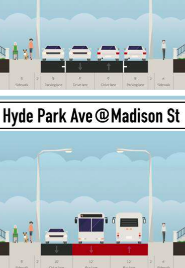
Neighborhood street with no parking
or bicycling facility. Also, no room for
a bus station. Yup, this makes sense.

Hyde Park to Forest Hills (32 bus). Here’s a line appropriate for BRT … if the street was wider. As it is, there would be enough room on much of the corridor for BRT, travel lanes and, well, that’s it. If there were a parallel street for, say, bike lanes, that might work, but there’s not. Hyde Park Ave is the main artery through the neighborhood, and it needs to be a complete street. The ITDP’s proposals leave enough room for one travel lane, or require one-way splits which are poor transit planning, especially if there’s a barrier (the Providence Line) in between. There is also no plan showing how to fit a bus stop in to to these narrow areas. Presumably everyone will walk a mile to wider parts of the street as empty buses roll through?

Then there are other users. There is, apparently, no need to have provisions for cyclists in Hyde Park Ave. We often talk about making streets more comfortable for cyclists, and a single travel lane shared with cars is certainly not a high level of comfort. This is also not somewhere where bike/bus lanes make sense, as buses would be slowed by passing cyclists more than they are in traffic (more on this later; in some short segments they do make sense). So to speed buses, all cyclists will either have to poach bus lanes, risk narrow travel lanes with no shoulders, or take a circuitous route. More likely, they just won’t bike. And let’s talk about parking. This is a neighborhood street. It would be great to give people a BRT option, but you can’t build a street with zero parking. Not just politically. At all.

Is what is proposed even gold standard? Not even close. By the ITDP’s own standards, I doubt this corridor would score higher than the bronze level. Would the 32 benefit from stop consolidation, proof-of-payment fare collection, better stop amenities and bus lanes on the wider part of the corridor? Certainly. Again, to make an analogy to the Twin Cities, this is exactly what they’re doing with the 84 bus on Snelling. Fewer stops, better amenities, off-board fare collection. Costs a lot less, gets most of the benefits. Perhaps those are the steps to take, not pushing through a politically unpalatable busway which will anger drivers, cyclists and pedestrians, and which won’t have much marginal benefit.

Dudley to Longwood and Harvard/Sullivan. Like the Downtown-Dudley-Mattapan corridor, this is one of the most important corridors in the city. It links several transit lines with major employment centers, both current (Longwood, Kendall, Harvard) and upcoming or potential (Sullivan, Dudley, and nearly Assembly). But there are no wide roads between them, and the roads that do exist have numerous pinchpoints and bottlenecks. Constructing bus rapid transit would be a massive undertaking (The urban ring proposal was for a mile-long tunnel below the Longwood area, perceived as “the rich get their tunnel and the poor get pollution.” If you’re going to build a tunnel, as we’ve seen with the Silver Line, don’t hamstring it with low capacity bus service.) and still would be serving as a major crosstown and last-mile route with high and imbalanced peak transfer loads, resulting in a system unable to cope with capacity.

It has two potential outcomes which the Silver Line illustrates well:

  • The SL4/SL5 scenario. A watered down BRT that will fail to deliver the promised time savings. This has happened on the SL4/5 from Dudley to Boston. It doesn’t have enough signal priority, street width, or enough priority in congested areas (where it really needs it) and is barely faster than the bus lines it replaces (the CT2 and others). It hobbles along with relatively strong ridership, but never really attracts new riders or takes pressure off the downtown subways or achieves the time savings to attract new riders who currently drive. This is the far more likely scenario. It is notable that even the ITDP’s rosy predictions for this route offer only modest time savings.
  • The SL1/SL2 scenario. There is money and political will to build a proper BRT system: full signal preemption, elevated platforms, 60 foot buses, significant grade separations, the whole nine yards. We don’t have the street width for passing lanes, so the system is run as a single line. There are quickly diminishing returns once you start running more than 20 buses per hour per direction and it’s very unlikely that you can get beyond 30 buses (one every two minutes): minor fluctuations in passenger loading will quickly cause bunching. Considering that the corridor acts as a last mile transit line for several major subway and commuter rail lines, this is all but inevitable.

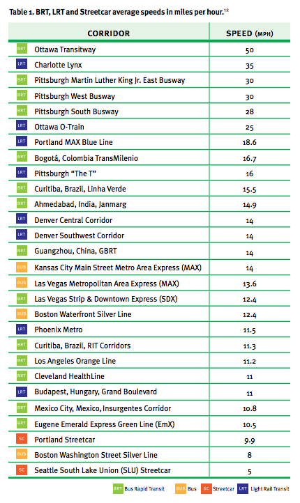
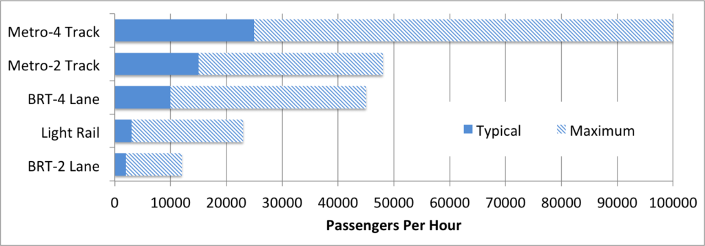
    So you get a white elephant: spending a lot of money (the SL1/2 cost $625m in 2004, equivalent to $800m today, or about half the cost of the GLX, with much lower throughput) and quickly go over capacity with no way to add more. The 32 buses hourly in the Silver Line waterfront tunnel have a theoretical crush capacity of 3,200 passengers (less, actually, given the luggage racks in the SL1, and bunching and delays as the buses can’t handle influxes of transfers at South Station). This is significantly less capacity than a single branch of the Green Line (which could be more efficient with fare pre-payment and signal priority), and less than a quarter of the combined capacity of the Green Line central subway, which, with 37 trains per hour carries more than 12,000 passengers. If the Green Line ran all three-car trains, it would have six to eight times the capacity of a BRT line.

This is particularly worrisome for these corridors because they have the potential to be a major last-mile collector system between Commuter Rail lines and employment centers, driving mode shift beyond the corridor itself. If you build an urban corridor and move 1000 people from driving 5 miles to riding a bus five miles, you save 5000 vehicle miles traveled each day. If that same corridor also serves as a good last mile connection for 1000 employees who each live 20 miles away, you quintuple the congestion and air quality mitigation, not to mention getting more people on commuter rail corridors, most of which have some excess capacity. But it has to be fast.

Right now, passengers from any Southwest Corridor line (Needham, Franklin, Providence) or the Worcester line have to go downtown and transfer to the Red Line to get to Harvard or Kendall; passengers from the north have to change to the Orange or Green lines at North Station to get to the LMA, all of them crowding the downtown subway system. Worcester passengers pass within a mile of Harvard Square and Kendall, but have to travel all the way downtown and then backtrack on the Red Line through downtown to get to work. Even LMA workers have to get off at Yawkey; at least it’s a short bus ride—or walk, even—from there. Thus, many drive, because these last mile connections take a lot of time and make transit less time-competitive. 

Even if there were more frequent, direct buses, they still would sit in gridlock on the BU Bridge (for the CT2) or Mass Ave to make these connections (and the Boston BRT report points out that there’s really no room on the BU Bridge for BRT; the Harvard Bridge might be a different story). For a worker coming to Kendall from Framingham, the fastest option might be to get off the train at Yawkey and walk. But this is not a great solution, nor attainable for everyone (especially given fickle Boston weather, we’re not all #weatherproof).
What these areas need is better grade-separated, high-capacity transit service. Yes, rail lines. The first is obvious: from the proposed West Station in Allston along the Grand Junction. MassDOT proposes DMUs, although for a corridor of this length it would make more sense to put up wires and run EMUs or integrate with the existing light rail infrastructure (and, perhaps, tunnel through Cambridge, which would increase the cost, capacity, utility and land values above-ground). Commuting from west of Boston to Kendall Square is a black hole for transit: taking transit requires 25 to 30 minutes just to get back to where you started from; surveys frequently show much lower transit commute percentages from western suburbs than other areas in the region. A good connection from Cambridge could shave 30-45 minutes off the transit commute daily, and there’s plenty of capacity on the Worcester Line for those commuters. It could also catalyze development with a station in Cambridgeport, which is currently a compendium of empty lots, parking lots and low-slung buildings. 
But the real meat is in where it could be extended. First, an extension of some service to North Station would provide better service between north side commuter lines and Kendall (full disclosure: I work for the Charles River TMA, which operates the EZRide Shuttle between North Station and Kendall and is too often hamstrung by traffic delays; these opinions are my own), the Worcester line and the North Station area, but would also provide a better connection to potential development in Allston. Another branch could circle around the back of the Boston Engine Terminal and serve the third and fourth iron tracks (to the west of the Orange Line) at a major new transfer station at Sullivan before extending to Assembly or perhaps even towards Lynn along the Eastern Route. With these tracks, and the overbuilt (in anticipate on lengthening) Orange Line station, there’s plenty of room for such a facility, being a major transfer point and serving a high-potential TOD node. (See page 97 of this urban ring PDF for engineering drawings.) On the west end, service could be extended west along the Turnpike to the new “Boston Landing” New Balance station, and perhaps further as local service to upgraded Newton stations and a 128 park-and-ride, while current commuter rail service could provide an express trip, local trains serve the inner stations, with cross-platform transfers in Allston. 
Kendall has a huge head start over pretty much anywhere else in the world for biotech (and some other tech as well) and a lot of that is because it has good transportation access, as a commenter in this Universal Hub thread said a lot of the reason it’s grown is that “none of the new hires and hot recruits wanted to move to [exurban] New Jersey.” It’s well-located. But to truly cement that lead, the community needs to embrace more transit capacity, and an east-west line to complement the north-south Red Line is, I think, the ticket. A winding bus rapid transit line? Probably not.
Then there’s the Harvard to Longwood section. In the short term, bus lanes on Mass Ave may be able to help the M2 to better provide this connection. And if West Station is built, a shuttle bus from Harvard to Allston will move commuters along that leg. But in the longer run, this is also a corridor which would benefit greatly from a new, underground, high-capacity transit service. If you’re going to tunnel under the LMA (and getting high throughput through the LMA is easier said than done on the surface), it should have rails in it, which allow for higher speed and higher capacity service. Buses in tunnels need to be guided, and are still hamstrung by lower speeds and wide loading profiles. If they’re not electric or dual-mode, ventilation is more of an issue than with electric rail. And the cost of a tunnel is the digging itself; it’s no cheaper to construct a concrete road in a tunnel than steel rails.

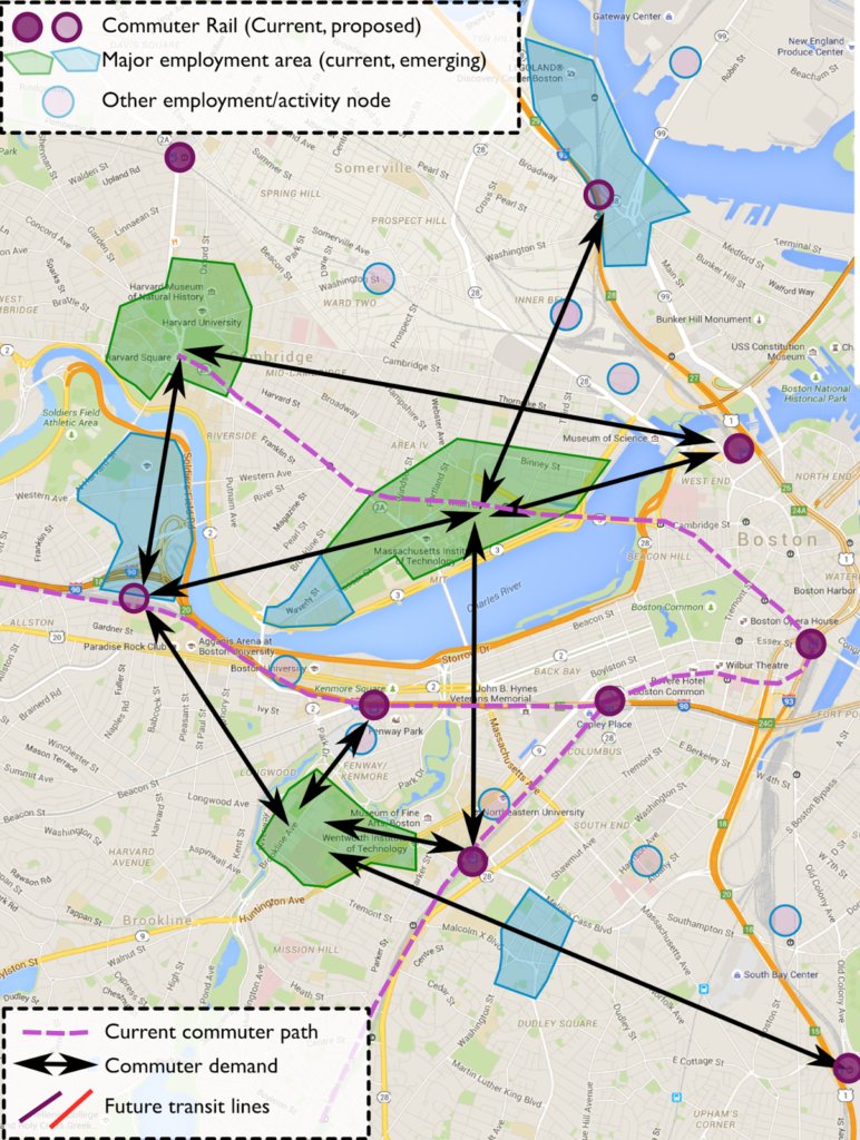
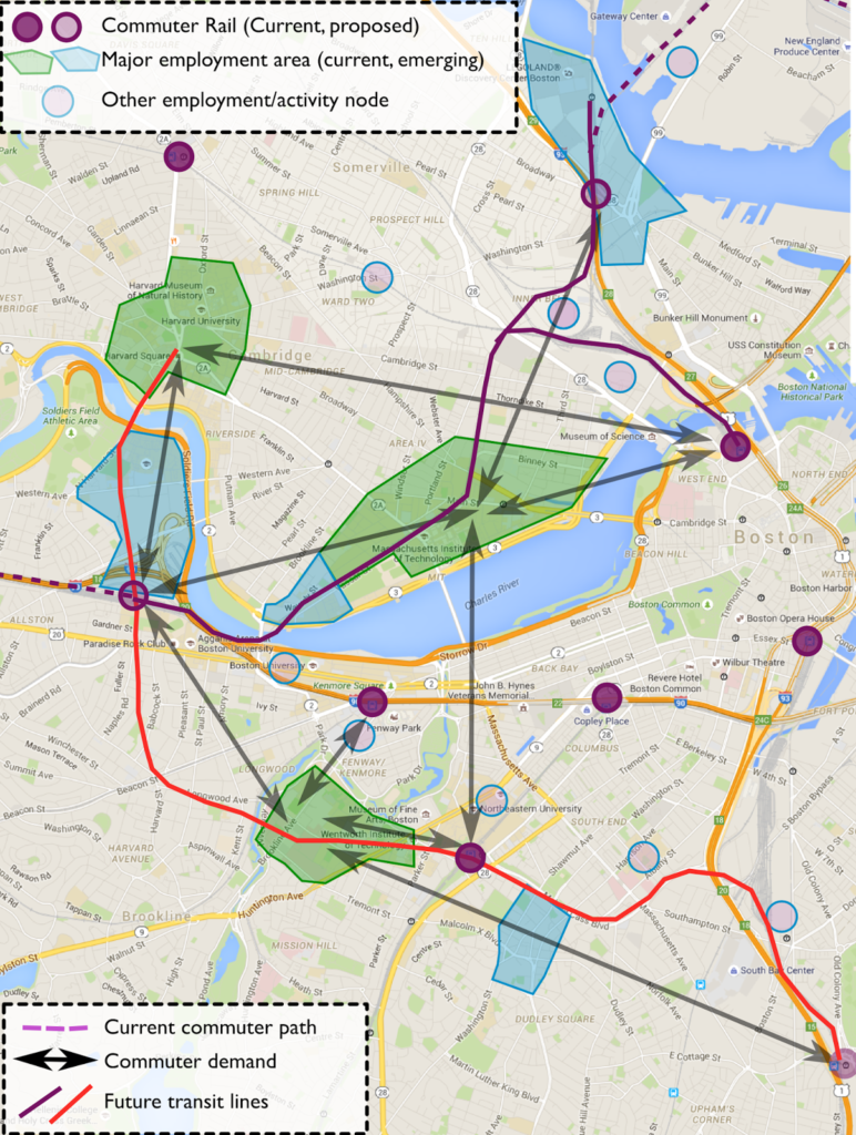
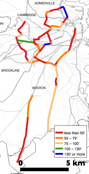
Above: major and emerging employment centers outside of downtown (green, blue), other employment/activity nodes (pink circles), Commuter Rail stations (purple circles). On the left, current transit routes and demand, on the right, how two new rail lines would satisfy most of this demand.


The advantage of buses is that they can run on the surface outside of a tunnel, so you only have to tunnel in the most necessary locations. The disadvantage is that once you build a tunnel for buses, you lose the capacity you might get with rail, so it’s a big investment for minimal capacity. The issue with this tunnel is that the most expensive portion to tunnel is also the most necessary: if you build that portion of the tunnel, it makes sense to build logical extensions on either end.

In this case, the line extends in two obvious directions from the ends of this tunnel: towards Harvard Square and towards JFK/UMass station, where it can connect, on both ends, to the Red Line. In both cases, in fact, there are already yard leads in place for this connection. Such a loop would connect all of the South Side rail lines (and the Fitchburg Line at Porter) with Harvard Square, Allston and the LMA. It would provide much better service than any amount of bus rapid transit could for an urban ring. It would cost more to construct, but provide a much better network enhancement by connecting the Commuter Rail lines—all of which have potential to add more capacity—with major employment centers with which they are currently disconnected, and provide far speedier service than any at-grade option.

The easier Red Line connection is on the south end. North of JFK/UMass Station, there Cabot Yard leads extend, grade-separated, north towards South Station and the Red Line yard. This is basically a full two-track subway line for a mile from Columbia to Widett Circle (for what its worth, this line would basically connect all of the Olympic venues Boston2024 has proposed, as well). The next mile and a half to Ruggles could follow the Melnea Cass right of way (cut and cover: cheap, fast and it doesn’t impact parking or businesses), which was cleared for the unbuilt Inner Belt highway. Using this right of way would mean that a tunnel could be built below grade as a cut-and-cover project, far cheaper than a bored tunnel, with minimal land takings. It would also serve Boston Medical Center with a subway station.
From there, a tunnel boring machine would be needed under Longwood and Brookline. The launch box for the machine could be built in the Melnea Cass easement on one end and the Allston yards at the other; much of the cost of using such technology comes from the land needed to put the machinery in and out of the ground (see San Francisco, for example), but in this case, there is open land available. This section would provide an easy connection between the LMA and Ruggles, JFK and West Station, making the area far easier to access from the Commuter Rail system. This tunnel, with stations, would likely cost in the range of $2 to $3 billion. But it would transform the transportation options in the area far more than any other project for decades to come.
From West Station, another cut-and-cover tunnel could be built up towards Harvard Stadium and the under the river (probably a trench-and-box procedure since the river is quite shallow here) towards the JFK School. The state actually owns the pedestrian corridor through the JFK School campus to the old yard leads which still exist behind a cinderblock wall. (Don’t believe me? Check out these pictures. You could lay track in there tomorrow. More info in this foamernet thread.) Since Harvard has bi-level platforms, you could run trains on and off of the current trackage there without any crossing traffic since it’s a flying junction. Of course, this dramatically limits utility, because you would miss the Harvard station itself which is outbound of the wye.

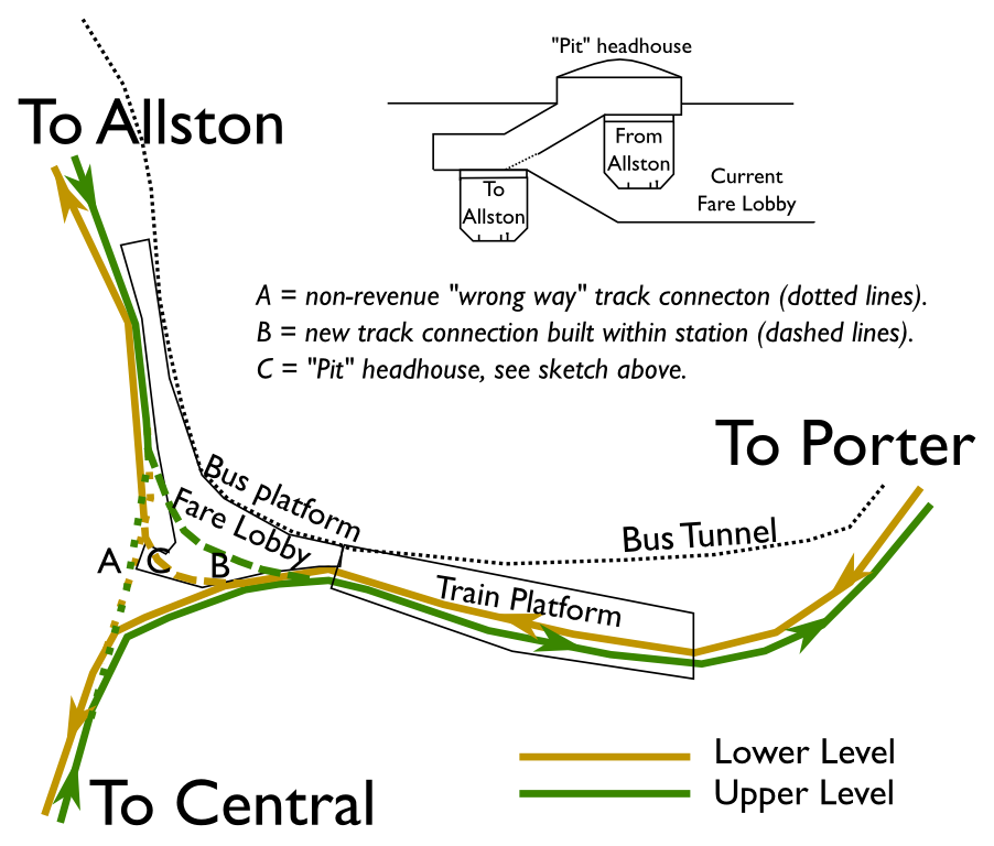
Obviously, just a sketch, but it’s likely something
could be fit in to the existing Harvard station without
completely rebuilding it a la 1978-84.

So you’d have to do some construction in the station. But this might actually be quite easy. The main issue is that to build a full wye, you’d need to have some trains switch levels, which doesn’t exactly work. If you didn’t have a Central-Allston leg of the wye (which you don’t really need, but which you could retain for non-revenue moves), trains could operate through the existing platform and then have a switch just east of the platform end and a curved tunnel to the existing tunnels (with a less-severe curve than the current line). All of this could be built within the existing station cavern. The major change necessary would be to relocate the stairwell from “The Pit” in Harvard Square, but that could use an update after 30 years anyway, and it could potentially be built in between the bi-level tracks (see sketch). Beyond there the tracks would be left-running (think Britain) but the line could fly over itself somewhere (cut and cover in Allston, or perhaps in the bored section) to regain right-side running for the connection to JFK/UMass.


(Update: Note that this is all conceptual, and there are obviously operational and engineering hurdles to overcome. Just like squeezing a four lane busway in to a 35-foot-wide right of way.)

All of this costs a lot of money, but look at the utility that you would gain:

  • Coolidge Corner to Harvard: 8 minutes (currently 25-30)
  • Ruggles to Allston: 8 minutes (currently 15-25)
  • LMA to Harvard: 11 minutes (currently 25-30)
  • Ruggles to Harvard: 14 minutes (currently 30-35)
  • Dudley to Harvard: 16 minutes (currently 35-40)
  • Porter to LMA: 14 minutes (currently 30-35)
You basically kill off the whole hub-and-spoke notion of Boston by putting Harvard Square, Allston and the LMA the same amount of travel time from most subways and commuter lines as downtown. A trip from Natick to Harvard goes from 55 minutes to 30, a trip from Canton to Harvard from 47 to 36, and a trip from Concord to Longwood from 71 to 47. For many commuters, you’re saving nearly an hour a day in transit times, and making transit commuting time-competitive with driving, something which, in many cases, it isn’t today.
But isn’t BRT just as fast? Boston BRT claims a 42% time savings between Dudley and Harvard, going from 57 minutes to 34. This is impressive! Of course, it’s not true. The actual scheduled travel time from Dudley to Harvard ranges from 22 minutes off-peak (on the 1 bus) to 36 minutes at heavy traffic times (via several modes, the Silver Line or Orange Line to Red Line or even the 1). The 66 bus does take this long (including schedule padding coming in to Harvard), but no one would suggest that it is the fastest way to travel between Dudley and Harvard. The loop described above would go from Melnea Cass and Washington Street to Harvard in about 16 minutes, less than half what the current travel time—or promised BRT travel time—affords.
In any case, the four corridors proposed by the Boston BRT study are certainly some of the most important in Boston. And in the short term, they are certainly candidates for better buses. However, trying to install “gold standard” BRT treatments is not necessarily appropriate: in some it would mean kicking cyclists and, yes, vehicles to the curb (literally!) and in others it would mean using the wrong technology for the necessary demand. If Boston had a Bogotá-style network of wide highways—and if it wasn’t bisected by a wide river with only a few crossings—then BRT might make more sense for these heavily-traveled corridors. But given the geography of the city, this is not the case.

Do we have the money for this? We should. Obviously, we need to invest in moving the system to a state of good repair. But we also need to keep up with our “competition”: many cities are building multi-billion dollar projects to enhance their transit networks. San Francisco is building the Central Subway and rebuilding the Transbay Terminal to better connect people and jobs. LA is building several transit lines and connections to enhance transit in the city. New York is building the Second Avenue line, the 7 extension and East Side Access, among others. Chicago, having rebuilt many of its elevated lines in recent years, is seriously talking about the Brown Line flyover. Boston is installing a few third rail heaters. (The GLX project is a good one, but it is more an extension than it adds capacity to the network.)

We do need to look towards the future. And while other cities are all embracing BRT as part of the solution, they are investing in their rail systems as well. The ITDP’s agenda of buses-only is a detriment to that approach, and thus we may run in place while other cities move forward.

In the next post, I’ll discuss places where buses could benefit from elements of bus rapid transit, even though it might not fit in to the ITDP’s arbitrary standard system.

What exactly is the ITDP’s agenda?

What, exactly, is the ITDP’s agenda, and why do they fight mode wars? They denigrate rail-based transit as if their opponents were well-funded machines slowly tracking over the world. In fact, LightRailNow.com, their “opponent” in the silly mode wars, is a small outfit in Austin which was originally founded to encourage light rail in that city, and doesn’t have the same funding or, agenda, it seems, that the ITDP does.

The ITDP says that its field of expertise is “Public Transport” but have a very narrow view of public transport: anything that doesn’t run on rubber wheels in a right of way doesn’t really count. This is really an open question: what is their agenda? Why not focus on better transit regardless of mode? Why publish reports with unsubstantiated statistics that don’t stand up to the light of day? Wouldn’t their argument be stronger if they reported the facts of BRT, and didn’t make up numbers?

As I’ve said before, I agree with a lot of what they say about the utility of bus rapid transit, but with one major difference. Bus rapid transit is an important part of moving people more efficiently, but only part of it. Buses, light rail and heavy rail transit each have their place, and need to be used where they are most appropriate. In a city like Bogotá, with wide boulevards and lower operating costs, BRT makes sense. In a city like Mexico, with gaps in a good rail network and relatively wide street, it does as well. In Cleveland, the HealthLine was likely a good investment in that corridor to spur development along the Euclid corridor. In Boston, BRT is certainly a good choice in some corridors. But, as I’ll flesh out in a final post in this series (yes, all things, good or otherwise, must come to an end), trying to shoehorn it in to certain corridors just doesn’t make sense.

I’d go as far as to say that the ITDP doesn’t really care about public transportation. They care about their bottom line. They want cities and foundations to pay them money to write reports using the metric they made up to analyze what they want to analyze. Good work, if you can get it.

Perhaps we should look north?

What is the best analog for the future of transit in the US? If you ask the ITDP, they point south: Mexico, Colombia, Brazil, countries which have invested heavily in bus rapid transit. It’s a rather curious comparison for a couple of reasons. First, those countries have much lower standards of living than the US does, so that operating costs for high-personnel transportation systems (buses require five to ten times as many drivers as trains) have a lower cost. Another is the streetscapes: many South American cities have Haussmann-style boulevards with plenty of room for BRT systems which are wide enough to support high-capacity systems. We don’t have that in the US. There is also a climate question. Countries with no freeze-thaw cycle can more easily build asphalt and concrete busways and expect them to last, while in the US, they require more preventative maintenance.

So perhaps the best place to look is not to our south, but to our north. That’s right. Canada. Unlike the US, no city in Canada had a pre-war subway system. When demand outstripped street supply, Canadian cities have taken a number of different tacks towards addressing transit needs:

  • Montreal’s looked to Paris and its Metro system is today the third busiest metro system in North America, with more than a million passengers daily, more than all but Mexico City and New York. It’s bus system carries another million and a half passengers.
  • Toronto’s Rapid Transit system also carries more than a million passengers per day, and is supplemented by the city’s extensive surface network, which carries nearly two million more passengers, and Go Transit commuter services, which launched only in the 1960s and carries nearly 300,000 passengers, and is being upgrade to electrified service to provide faster and more frequent trains. All told, Toronto has nearly 3 million daily riders, and TTC’s 73% farebox recovery ratio is the highest of any system in Canada or the US.
  • Ottawa’s OCTranspo carries more than half a million passengers daily, nearly all of them on buses. Many of these buses use mostly-grade-separated transitways and Ottawa is the only city in the ITDP’s database (scoring bronze status). Yet Ottawa is working to convert most of it’s bus rapid transit to light rail. Why? Capacity. The downtown segment, with 100 mostly 60-foot buses per hour, is oversubscribed. Even the ITDP admits it (although their circular logic is that this just points to the success of BRT, although they don’t give any solution for increasing capacity). 
  • Calgary and Edmonton both have light rail systems. Calgary’s is very well patronized, with more than 300,000 daily passengers using a single downtown trunk line, and illustrates that surface-running light rail can far exceed bus capacities in a limited corridor (including double the capacity that the ITDP quotes for light rail). Calgary’s system is now the most heavily-used light rail system in North America (yes, more than the Green Line in Boston) and both systems are expanding.
  • Vancouver hosts Canada’s newest rail system, Skytrain, a “light metro” system which is fully grade-separated but has slightly less capacity than a full metro. Most of Skytrain is above-grade, although several sections are in tunnels as well. Notably, it is fully automated, reducing operation costs further. The city has several very busy bus routes (particularly the 99 to UBC) which are planned to be replaced by Skytrain lines in the future.

Unfortunately (or maybe fortunately) the ITDP hasn’t studied these Canadian systems, because—especially in the case of the newer systems outside of Toronto and Montreal—they don’t fit in to “BRT good light rail bad” narrative. If Ottawa had built light rail like Calgary, they would not have the capacity constraints that are now causing them to build a light rail line instead. Downtown Calgary is booming for a variety of factors, but one is that its light rail line has the capacity to serve the number of commuters necessary to support the dense downtown without highways. It would probably be booming similarly had BRT been build instead, but it’s likely that system would be over capacity and, like Ottawa, would need significant enhancements or a mode change. Montreal had a bus rapid transit line that they’re rebuilding on a peripheral street for US$25m per mile, although costs are ballooning and it’s a lengthy project, and Montreal’s trunk lines are still served by underground rail.

Canadian cities have generally been successful in getting people to commute without driving, much moreso than in the US. Even in the Texas of Canada (Alberta), half the commuters to Downtown Calgary take transit to work (and Calgary does not have many large peripheral office parks; development is focused downtown). Bus rapid transit has worked in Ottawa, but congestion, especially in the downtown area, has caused the system to be replaced with light rail. While the outer portions work with buses, where many routes merge and streets get narrower (and Ottawa has a grid street system downtown with relatively wide roads) it has been overwhelmed.

So, back to Boston, a city which is more similar to Canadian cities than it is to, say, Mexico or Curitiba. Canadian cities have somewhat similar development patterns, highways (Montreal and Toronto both have highways serving downtown and terrible traffic, does that sound similar?) and standards of living. The ITDP chooses analog cities of Cleveland, Mexico City and Belo Horizonte in Brazil. These are examples of cities which have bus rapid transit. I’m just not sure how well they compare to Boston.

How much does BRT cost? 7X less than LRT? (Hint: No.)

This is the third in a series about the ITDP bus rapid transit report for Boston, and the ITDP standard in general.

One of the claims often made by BRT propagandists is that constructing bus rapid transit is seven times cheaper than light rail transit.

This is from the executive summary of the ITDP’s Boston BRT report:

Analysis of recent transit development costs
in the United States suggests that implementing BRT in these
corridors would also be more cost-effective than other options
for improving the existing transportation system. Based on this
evidence, on average, BRT can be seven times more affordable
per mile implemented than light rail.

Their “Benefits of BRT” page repeats this factoid several times. Quite a ways down the page do they use some properly weasely language to qualify their statement: “BRT can on average be up to seven times more affordable than light rail.” (Italics mine.) Hey, guys? That’s now how averages work. An average is the sum of a set of numbers, divided by the total number in the set. It’s like saying “In February, Boston gets, on average, up to 65 inches of snow.” Boston must be a snowy place, a reader would say, since some there must be a lot of years that have more snow than that. Except “up to” denotes an outlier. Boston normally gets, in average, about 12 inches of snow in February. 65 inches is an outlier. The ITDP report is off by about the same factor.

If this seven-times-as-expensive figure were the case—especially in corridors where demand is not likely to exceed 2500 passengers per hour—then it would make a lot of sense to build, right? If you can get 25 miles of BRT for the price of four miles of light rail, it’s a no-brainer. But what about if you can get nine miles of BRT for the price of four miles of light rail? Because that’s the actual ratio: light rail comes in at slightly more than twice the cost. And the while the ITDP bandies about that number, they cite no actual evidence to back it up.

Given the capacity constraints of bus rapid transit, it becomes a harder choice: if you spend half the cost of light rail on a bus system that doesn’t have the capacity to serve the needs of the corridor, it’s wasted money. It becomes a sort of Yogi Berra white elephant: no one goes there anymore, it’s too crowded. Crowds seem like success, and they are, to a point. But overcrowded transit runs more slowly and is more prone to uneven headways. In other words, if you build it, and they come, then what?

* Planned for ~2020. Ridership includes 38, 38R, 38AX, 38BX
† Included significant grade separation/bridges/tunneling
‡ Primarily in an existing right-of-way
All dollar figures adjusted for inflation (2015)

I like charts (you’ll know that if you’re a frequent reader) and here is one. It shows the costs per mile, and daily ridership, for a variety of BRT and LRT projects which have been built recently. I included several Los Angeles LRT examples because it is the only city which has built both BRT (to the level of an ITDP standard) and LRT in that time, and included the much older (relatively) Blue Line because it was mostly built on an old Pacific Electric right-of-way, much like the BRT Orange Line. Is light rail more expensive to construct than bus rapid transit? Yes. Is it seven times more expensive? Certainly not. The distance-weighted average construction cost for light rail is about 225% higher than BRT, less than a third of the difference that the ITDP suggests. (I’ve left out rail examples here—the Central Link in Seattle, for example—which include significant tunneling or grade separation, and similar BRT systems.)

There is only one example of BRT construction which is seven times less expensive than any similar light rail line: the Emerald Express in Eugene, Oregon.

Eugene, Oregon The Emerald Express was cheap to build: but you get what you pay for. The line serves a transit system which has a daily ridership of 40,000; fewer than most of the light rail lines above. It runs every ten minutes—frequent by the standards of a small town—but will require significant more investment to go any faster. Why? Because many of its exclusive lanes are bidirectional: a bus may have to wait for a vehicle going the other way to clear. It’s like a single-track railroad with passing loops for buses. And the stations are not what you’d see in Bogota: here is one along a less populated stretch of the route. This is not to say that there’s anything wrong with the Emerald Express—it is good for the community it serves. But that type of infrastructure would be overwhelmed on opening day in Boston.

Oh, also: the second leg of the Emerald Express—with similar BRT features—is coming in a bit higher: $19 million per mile. So the one-seventh number? It’s pretty selective.

Los Angeles Then there’s the Orange Line in LA. It is certainly successful, relative to an unused corridor, anyway. It runs every four minutes and carries 30,000 passengers per day. It’s basically at capacity. It cost $27 million per mile to build initially (but the recent extension was more than $50 million per mile), and has a third the capacity of the Blue Line, built in a similar corridor. It wasn’t built as light rail because, well, it’s along story that includes Orthodox Jews and corrupt politicians. You can’t make this up. Since it’s over capacity, there are initial plans to improve capacity (costing another $20 million per mile) or convert it to rail ($65 to $95 per mile).

The cost for a bus line that will perform anywhere near the level of a rail line will wind up being just about as high, and will still have a much lower capacity—certainly nowhere near the 90,000 passengers the Blue Line carries. Of course, there’s a sunk cost issue. Having already spent $600 million on a busway, there’s an argument not to “throw this money away”. But the total cost for the busway could come to $1 billion by the time all is said and done, about what light rail would have cost in the first place, with a lower overall capacity. So the BRT is really a white elephant, even if it’s one that transports a lot of people. This is a perfect illustration of the problem I posited above: you spend a lot of money on a project and quickly it is overburdened.

Cleveland Perhaps the best example of a successful BRT line in the US is the HealthLine. It was built along six miles of Euclid Avenue from downtown east towards a university/hospital cluster (including, yes, the eponymous Cleveland Clinic, and Case Western, too). It carries about 14,000 passengers per day, and does so in a well-designed corridor (the only one in the US to qualify as Silver based on the ITDP’s standards). The corridor varies between about 70 and 90 feed wide. The cost? $30 million per mile. It was probably a good investment. There is a roughly parallel heavy rail line that makes the end-to-end trip faster, so there’s never likely to be very heavy corridor ridership, and it likely won’t have to scale beyond it’s single-lane capacity. Of course, this rail line has plenty of capacity (it is by far most lightly used metro system in the country) between the HealthLine’s endpoints, so there is a valid question as to whether these investments were necessary.

BRT boosters (ITDP) point out that the HealthLine has been the $5.8 billion of development which has taken place along the line. (Well, other sources put the number in the $4 billion range; it’s a big number.) Which is great. But two important caveats. First: correlation does not imply causation. Much of this development was planned out well before the line was built. Much of it likely would have taken place if no improvements had been made. It’s not like the Cleveland Clinic (with 1500 beds and $9 billion in annual revenue) waited for the bus line out front to be built. Or that Case Western—with a $2 billion endowment—didn’t spend any of it until the HealthLine was completed.

The comments by Coolebra in this article flesh this out very well, as does this article. As one commenter there quips:

I could probably go put a giraffe near the Cleveland Clinic, and surely the Clinic will build another building within the next 24 months (or two). I can publish a study showing that giraffe investment is the best way spur development as cities run around to put giraffes across their neighborhoods.

The point being: there are a variety of factors which account for the return on investment for any transit line. Crediting all of it to a single source is folly. And let’s all say it together: correlation does not imply causation!

Second: most of the improvements have taken place on the eastern end of the line. This happens to be where it mostly parallels the aforementioned Red Line rail line. Saying that all of the development in the area occurred because of the HealthLine would be like ascribing all of the development between Dudley Square and the Financial District in Boston to the Silver Line. It helps, but there are a couple other factors—and rail lines—involved.

So there’s nothing wrong with the HealthLine, per se. It is a decent investment and has room to grow. But there needs to be a bit more nuance in analyzing it’s ability to leverage private investment than claiming that anything built within a stone’s throw—a college campus and two major hospitals—is only there because of the BRT. (In fact, they’re there because of transit—originally, Euclid Avenue had a streetcar, of course.)

Hartford Very recently-opened is CTFastrak in between Hartford and New Britain. Like the HealthLine, it probably doesn’t have the capacity needs for a rail line, and there’s no existing light rail infrastructure in Hartford to build upon. It’s reasonably fast, mostly grade-separated, and serves both buses along the line and others that enter the line part way along it. (It’s brand new, but has been getting good reviews.) Of course, it cost $60 million per mile to build, which is comparable to most new light rail lines. It will probably score well when the ITDP comes to town (separate platforms, some passing lanes, etc) and they’ll probably gloss over the fact that it cost as much as a couple of sets of railroad tracks.

It might be a good time to point out another hidden BRT cost: maintenance facilities. Light rail costs almost always include the operating fleet as well as the cost of maintenance facilities. Most BRT systems makes use of existing maintenance infrastructure, at least to start, which reduces costs in the short run but in the long run will require more or larger garages to be built down the road, especially if the line is successful (the cost of the vehicles is usually included in the cost of the system). I don’t believe BRT costs have future maintenance facility requirements amortized in to their figures. Since these are likely shared with other bus operations, the costs won’t be factored in to the cost of the system. Such facilities can cost more than half a million dollars per bus, adding a million dollars per mile in costs for frequent systems.

San Francisco And then there’s Geary, one of the busiest bus lines in the country. It has more than 50,000 daily passengers spread out among four routes, the 38, the 38R (a limited stop route) and two rush-hour express routes, the 38AX and 38BX, which serve an outer portion of the line before using other streets to access downtown San Francisco. In a sense, these already function as a local-express BRT network, just without the bus lanes, stations and other amenities the ITDP looks for. So basically BRT, without the R. Do they function well? Hard to say. People seem to like the limited and express options (I mapped their Yelp scores a few years back) although at rush hour the 38R, which comes every four minutes, is at or near capacity (running 60 foot buses).

The city is planning to build BRT and have it “light rail ready” because they don’t have the money for light rail. The problem is that this is going to have the capacity issues that the Orange Line has in Los Angeles on day one. Yes, better platforms, signal priority and wider doors may help, but the system already carries more than 3,000 passengers per hour, so it won’t have the capacity in a two lane system. Much of it is being built as side lanes instead of in a center median, especially in the inner part of the route, so limited buses will be able to pass locals in mixed traffic lanes. But it won’t really solve the capacity crunch, especially if there’s traffic in those lanes.

There are two ways to add enough capacity on Geary. One would be to build light rail. A three-car light rail train every five minutes would carry 6000 people per hour and not be at capacity. The second would be to build a full-on four-lane Bogotá-style BRT system. The corridor already has local, limited and express buses: at rush hour, there are nearly 60 buses per hour serving the corridor. This would allow buses with different service patterns to skip stops easily, and as we’ve said before, a multi-lane system does have capacity that will match light rail.

There are only two issues. The first is that even the half-baked BRT system will cost $50 million per mile (and run in to the same white elephant/sunk cost issue as LA has). A four-lane system would likely cost more, getting in to the range of the average light rail system. The second is that while there is enough space on the street for this type of system, there’s not much to spare. Geary is about 100 feet wide—one of the widest streets in San Francisco—but it is still narrow compared to most streets in Bogotá. Since most highways in the City were never built (or removed) and these few rider surface streets, it functions as a thoroughfare, as well as a shopping street. So to take four lanes plus stops for a busway would leave only 35 feet or so on each side, barely enough for one lane and parking. This likely wouldn’t fly, so you get single-lane BRT: pretty expensive, but minimal improvement to capacity. The B-Geary was one of the last lines in San Francisco to lose streetcar service, and the only way to keep enough of the road for cars and have enough transit throughput is a light rail line, even if it would cost more. BRT is, to quote Sarah Palin, lipstick on a pig.

Minneapolis-Saint Paul There are several light rail lines which have been built as well; for some of them there was a conscious choice made between bus and rail transit. The Green Line between Minneapolis and Saint Paul is one. When it was proposed, bus rapid transit would have cost about a third of the cost of rail. But it’s unlikely that it would have been able to handle the passenger loads that the rail line carries, especially since it serves both the University of Minnesota (with 50,000 students, one of the largest in the country) and both downtown Minneapolis and Saint Paul (Minneapolis being the larger traffic generator). The line already carries 35,000 passengers daily—more than the ten-year-old Blue Line (which was built along an already-cleared but never-built freeway right-of-way)—a year in to service. With those riders, Minneapolis now has the highest ridership of any light rail system opened since 2000.

It also serves the Cities’ main sporting arenas (the ballpark, hockey, basketball and both football stadiums and the minor league ballpark; and yes, the Twin Cities may be the most over-stadiumed city in the country), so in addition to heavy loads at rush hours, it has to cope with frequent event traffic as well. If it were a bus rapid transit system, it would have been overloaded from the start. As a light rail line, it can cope with demand with 10 minute headways at all times (except overnight, and, yes, it runs 24 hours a day), which means it could easily double capacity—or more—if ridership increases.

Which is not to say that the Twin Cities don’t have any bus rapid transit. They have a couple of freeway-based lines (which don’t really conform to ITDP standards) and are planning several arterial lines, which may not have exclusive lanes but will have better stops, all-door boarding and more frequent service. One, on Snelling Avenue, intersects the light rail lines near both lines’ midpoints. While Snelling once had a streetcar, it probably wouldn’t merit one today, but it connects the two rail lines and will provide an important link in the region.

While the Twin Cities may be somewhat light rail-heavy in their planning, they are choosing appropriate modes for each corridor. They aren’t hamstringing heavily-used routes with inadequate BRT because it’s cheaper (or because buses are always better, or something) but aren’t spending on light rail where BRT will do the trick (the streetcar plans are another story, and how I feel about them—conflicted—is the topic of another post entirely). Rail cost more than twice as much as BRT would have (but certainly not seven times as much) on University Avenue. But it provides more utility than BRT on day one, with room to grow. It was a smart investment, and the right choice.

I’m more familiar with the Twin Cities than other regions, but imagine there are others which act similarly. But the ITDP wouldn’t give them the time of day and certainly doesn’t examine rail systems as “gold standard” or otherwise. Perhaps it’s time we took a more holistic approach towards analyzing transit investments—looking at ridership, throughput and actual costs, not hyperbole—rather than engaging in mode wars (the Transport Politic made just this point recently). Let’s choose the right mode for each corridor, not blindly push for one over another based on preconceived agendas.

What is the actual capacity of BRT?

This is the second in a series about the ITDP bus rapid transit report for Boston, and the ITDP standard in general.

When proponents of Bus Rapid Transit—

You know what? I need to redefine this. I am a proponent of BRT. But I am a proponent of BRT in context. When the ITDP talks about transit, they only mention BRT. Heavy rail, light rail, commuter rail, these are seen as competition, and need to be denigrated whenever possible. BRT is the solution, anything else is not even worth mentioning. 


This is myopic. Bus rapid transit is a tool, but just a a tool box needs more than just a hammer, transit needs a variety of modes working together depending on a city’s existing infrastructure, needs and geography. BRT needs to be used where and when it is appropriate, but it is not a one-size-fits-all solution for every transit need. I’ve already discussed how BRT is not particularly compatible with narrow streets, and how the cities used as analogs to Boston are anything but. 

—So to begin again:

When propagandists of BRT (yup, I went there, ITDP) talk about the benefits of bus rapid transit, they don’t tell the whole story. Their argument is that bus rapid transit has the ability to transport as many people as any other mode (45,000 per hour!), at a fraction of the cost. In very isolated cases, this may be true. However, they don’t mention that this is an extreme outlier. The infrastructure required for that number takes up enough space that it is compatible only in urban areas with long, wide thoroughfares with space to build. Without this, capacities are an order of magnitude lower, and BRT is much harder to scale than rail.

Here is what the ITDP shows for capacities in people per direction per hour:

This is somewhere in the neighborhood of being true (it’s, shall we say, rosy), but it shows absolute maxima, which for BRT are often attained in conditions which, in most cities, are unworkable. (Let’s also set aside the fact that 6000 people per hour on a non-BRT bus system equates to 1 minute headways, that a four-track metro like the 6th Avenue Line in New York runs at a capacity of 60,000 per hour and theoretically could run at 100,000 and that light rail is capable of more than 20,000 passengers per hour in, for example, Calgary. So, it’s basically not true then; see below.) The BRT number is from Bogotá, and it is an outlier. The way that Bogotá attains that number is by having the BRT system in the center of a highway with wide stations and two lanes for buses on either side, necessitating about 70 feet of street width. This requires four bus lanes at stations, and the street width to accommodate that something many cities just don’t have.

Without this width, BRT carries many fewer people. Bus and rail transit scale in two very different ways. Imagine (or look at the chart to the right) a graph where the X axis is the route, and the Y axis is the width of the corridor or the number of lanes/tracks. Rail scales along the X axis, by adding vehicles to the train, so that going from one car to 10 cars gives ten times the capacity. However, adding a second track (increasing the Y axis) only doubles capacity, there are no similar economies of scale. BRT can only lengthen the vehicle so much; most BRT buses top out around 100 feet (carrying about 160 passengers). However, doubling the number of lanes a BRT uses increases capacity by 10 times (or even a bit more; the most frequent route in Bogotá has 350 vehicles an hour—a bus ever 10 seconds!). So while rail can scale by an order of magnitude within a narrow corridor, BRT scales best in another dimension. However, this requires four lanes of width, plus stations, to have the same increase in capacity.

This becomes an issue when capacity is an issue. For a line transporting 1000 or 2000 people an hour, rail is no better than bus: a single-car light rail train every 8 minutes has about the same capacity as a 60-foot bus every 4 minutes. (This is assuming they have similar signal priority, level boarding and fare collection mechanisms to minimize dwell times and unnecessary stops.) Both these frequencies are show-up-and-go frequencies; the average wait time for a three minute headway versus a six minute one is a negligible 120 seconds, a small percent of total trip time.

But if demand increases, a rail line can easily add capacity while a BRT system can not. Increase demand to 3000 people per hour, and a rail line will handle it fine: a two-car light rail train every seven minutes does the trick. However, a BRT system maxes out around 60 trips per hour, and even at this point, even a minor load imbalance (say, from connecting services) or a traffic light cycle missed (say, to allow pedestrians to cross*) will cause bunching. There are diminishing returns at very low headways as being slightly out of sync can cause bunching and crowding issues. There’s a reason the BRT line in Los Angeles (the Orange Line) has four minute headways, and not less. Beyond that, bunching, and accompanying diminishing returns, are inevitable.

[Update: Mexico City has more frequent service, it’s just that Google Maps transit doesn’t show that. Thanks, Google Maps! And I didn’t go in to the GTFS file to see what was going on, and it’s a somewhat complex file! So, Mexico’s BRT system has higher throughput, especially given their longer buses, maxing out around 12,000 per hour. Of course, with vehicles every minute at-grade, bunching is inevitable as crossing phases have to be a certain length on wide streets, so speed declines. It’s certainly faster than minibuses in mixed traffic, which the system replaced.]

Beyond 3000 people per hour? A two-lane bus system has problems; crowding will increase dwell times, and capacity or speed may actually go down. A light rail line will reach this point as well, but will be carrying many more passengers when it does so. Boston and San Francisco run 35 to 40 light rail trains per hour underground, with a capacity of 15,000 passengers per hour (Boston, with some three-car trains, actually has a slightly higher capacity). Calgary runs 27 three-car trains (with plans to increase to four) through downtown at rush hour, at-grade! 27 four-car trains will give it a capacity of 22,000 per hour. (Their system carries more than 300,000 riders per day, higher than Boston or San Francisco.) That’s on par with pretty much any BRT system (Bogotá’s is over capacity, and they are actively looking to build parallel lines to reduce the demand on the main trunk routes.), but the stations and track only take up about 40 feet of street width, enough for a lane of traffic and wide sidewalks in an 80-foot building-to-building downtown corridor, still narrower than any BRT street in Bogota.

In any case, the chart that the BRT report has should actually look something like this, accounting for typical loads and outliers:

Typical loads are lines such as the Broadway IRT for the four-track metro, the Red Line in Boston for the two-track metro, a single branch of the Green Line for the LRT, and the Orange Line in LA for BRT. I took a guess at the typical throughput of a four-lane BRT; I couldn’t find any specific schedule or loading data.

Maximum loads are theoretical maxima. For a four-track metro, this is double a two-track metro (the 6th Avenue line is the busiest trunk line in New York, running about 30 trains per hour with a capacity north of 60,000, but could carry more). For two-track metros, several are in the 40000 range: the Victoria and Central lines in London (33 trains per hour, 1150 passengers per train), and the L train in New York (20 trains per hour, 2200 passengers per train). For BRT, four lane, the number is from Bogota. For light rail, the number is from Calgary, assuming they implement four-car trains as scheduled this year. And for BRT, two lane, the number is from a single-lane, one minute headway system with 100-foot buses (which don’t exist in the US).

Two notes:

  1. Bogotá’s system is an outlier. Most BRT systems carry many fewer passengers, especially the majority of lines which do not have passing lanes at stations to increase their capacity. While light rail can scale dramatically, BRT can not, unless the streets are wide enough. Which, in Boston, they’re not.
  2. Four-lane BRT is akin to four-track metros in capacity enhancement (a four-track metro can carry, in theory, more than 100,000 passengers per hour). However, a four-track metro is only necessary in very high demand situations; most two-track metros can be scaled to meet demand. Four-lane BRT, however, is necessary even when demand is well below what a typical metro line, or even light rail line, might carry. 

Here’s another way to look at capacity. It shows how different transit modes attain capacity: rail by adding vehicles (and, to get very high frequency, extra tracks) and BRT by adding passing lanes and frequency. It also shows a dotted line at 60 trips per hour—a one minute headway. Most systems operate to the left of the dashed line. In the case of rail systems, this is because more capacity is generally not needed. In the case of BRT, however, it is because the system is operating near its maximum. In reality, the lines should curve flatter beyond 30 trips per hour (except for four-lane BRT) as bunching and load imbalances cause diminishing returns.

In any case, it’s another way to show that while BRT is a useful tool in the transit toolbox, it has a very finite capacity unless it can be expanded to four lanes (plus stations). If you are trying to design a system which can scale, you either need to have that corridor space available (as is the case in Bogotá), or build a rail line. Without that, bus rapid transit can carry about 2500 passengers per hour, but it can’t scale higher.

[ * A note on pedestrians: surface BRT is constrained by the length of crossing traffic light cycles. Even with full signal preemption, a crossing cycle needs to be long enough to clear crossing traffic, and for pedestrians to cross the street. In most cases, a BRT corridor will be wide enough to require 30 seconds of pedestrian crossing time. At 5 or 6 minute headways, this is not a problem; the BRT only requires 10 or 15 seconds every two to three minutes, or so. At three minute headways, it requires 15 seconds every 90 seconds, and at two minutes, 15 seconds every 60, and at a minute, BRT requires half of the signal time. It is likely that buses at this frequency would, at times, be forced to stop because of the length of the pedestrian phase (and to keep cross traffic flowing at all), which would create bunching and crowding problems downstream. Again, most single-lane BRT networks operate at four minute headways, which constrains capacity. Beyond that, they lose signal priority advantages, which constrains speed. In other words, there’s a fair argument that for surface transit, a three minute headway may be better than a one minute headway.]

Boston will not have “Gold Level” BRT: the streets are way too narrow

I’m digesting the study from Boston BRT from the ITDP group (second installment on the actual capacity of BRT here) and while I certainly appreciate forward-thinking planning in transit, I feel that they are selling us a bill of goods in several respects. One is promising that Boston can cheaply and easily have a “Gold Level” bus rapid transit, a level attained only by a handful of South American cities. The problem is that Boston’s street geometry and grid does not allow for that level of service, even by the ITDP’s own scorecard. We shouldn’t marry ourselves to an artificial and unattainable standard, but we should build the transit system that we need.

The scorecard is out of 100 points, and you need 85 to meet the gold standard.

Here are the Boston BRT’s routes, and their highest possible scores (within reason, anyway) based on the detailed ITDP scorecard (sorry for the janky Blogspot table format):

Criteria Points Blue Hill Ave Dudley-Downtown Hyde Park Ave Dudley-Harvard Dudley-Sullivan Notes
Dedicated Busway 8 7 5 5 5 5 Assumes separated lanes for 75% of BHA, and colorized/exclusive lanes for 75% of other corridors.
Busway Alignment 8 8 5 5 5 5 Assumes an average of 5 points for corridors other than BHA.
Intersection treatments 7 5 5 2 2 2 Will be hard to ban turns across busway outside of Blue Hill Ave corridor. Assume some turns prohibited and signal priority.
Multiple Routes 4 4 4 0 4 4 No other buses use Hyde Park Ave
Demand Profile 3 2 2 3 3 3 Highly dependent on high-demand areas, which are often the most space-constrained. 
Center Stations 2 2 1 0 1 1 Center stations + lanes require 32 feet of width.
Station Quality 3 2 2 1 1 1 10 foot required width unlikely at all stations in narrower corridors.
Pedestrian Access 3 3 0 0 0 0 Requirement of 10 foot sidewalks rare in Boston.
Bicycle Parking 2 1 1 1 0 0 Standard of bike racks in most stations unlikely.
Bicycle Lanes 2 1 1 1 1 1 Some bike lanes qualify for one point.
Bicycle Sharing 1 0 0 0 1 1 Requires bike sharing at 50% of stations.
Systemwide 55 47 47 47 47 47 See Below
Total 8 82 73 65 70 70

Systemwide points assumes that Boston could qualify for full marks in a variety of categories, i.e. there are no physical constraints: operating hours (2), comtrol center (3), platform level boarding (7, although this may be difficult on downtown corridors), top-ten corridors (2), multiple corridors (2), emissions (3), intersection setback (3, assuming exceptions for frequent short blocks), pavement quality (2, although whether a 30-year pavement is attainable in New England’s climate is unknown), station distance (2), 2+ doors (3), branding (3), passenger information (2), accessibility (3), system integration (3).

Systemwide points where Boston would not qualify for full marks: fare collection (7/8, assumes full proof-of-payment system; otherwise it requires turnstiles at each station), express-local service (0/3, requires passing lanes), passing lanes (0/4, requires wider streets), docking bays (0/1, requires passing lanes).

Given these scores, the highest corridor scores 82, three points shy of “gold” standard, and that’s being quite generous in some categories (i.e., it will be tough to ban turns for most vehicles since there is not an adjacent grid which can handle the excess traffic, or squeeze in bike lanes in already narrowed corridors, and I’m still not sure why renderings along, say, Hyde Park Avenue don’t show stations, which take up a good deal of space). Two other corridors make the “silver” standard of 70 (barely), and the others are “bronze”. Even still, it would be a lot of work to shoehorn in enough ITDP-standard busway to meet that. Mexico City, which the report uses as a model, doesn’t even reach the gold standard on any of their lines, despite most of them running in streets wider than in Boston. In the US, only Cleveland has attained silver level, and Euclid Avenue there is mostly 80 feet wide (110 feet between buildings) and the narrowest parts are 60 feet wide. We need to have better-performing buses in Boston, but we need to adapt what works in other cities, not wed ourselves to a metric that is ill-suited to our city’s older, narrower streets.
I sketched the BRT networks in Bogotá and Mexico D.F., showing the curb-to-curb street width of each street where BRT operates. I divided the streets in to five categories:
  • 130 feet or wider. This is the majority of street widths in Bogotá. 
  • 100 – 130 feet. This is the minimum width in Bogotá except for two short portions: a narrow portion to a terminal downtown on a bus-only street (which is still 50 feet wide at its narrowest) and the southern portion, which runs non-stop through an undeveloped area to a terminal station. This is generally the minimum for passing lanes at stations.
  • 75 – 100 feet. This is the minimum width of most streets in the Mexico City network. Few Boston streets are even this wide. This generally permits single-lane stations, but not stations with passing lanes. This is the bare minimum width for a “Gold Level” BRT (although Mexico’s system is rated “silver”.
  • 55 – 75 feet. This is the minimum width of any BRT line in Mexico City. This is the minimum width for a complete street with two lanes of BRT, a station and either two lanes of traffic or one lane of traffic and bicycling facilities.
  • Less than 55 feet. There is no way to fit BRT on a street this wide without removing all but one lane of traffic. While BRT can run on streets of this width, they have to be in areas which do not require any auto access, and nearby streets need to be able to host adequate bicycling facilities. In a city like Boston without any street grid, this is impossible to provide. There might be a it of fungibility at the high end of this scale—something like the 53-foot-wide Harvard Bridge which could have a bus lane, a travel lane and a bike lane on each side, barely—but only in areas that don’t require any stations, at which point it’s just too narrow. 

One of these things is not like the other. Much of the supposed gold standard BRT route network in Boston is simply too narrow to have gold standard BRT. It’s also worth noting that while in Bogotá and Mexico BRT runs in relatively straight lines, in Boston, outside of Blue Hill and Hyde Park avenues, it’s much more serpentine. This is because of the cities’ unique geographies, and it doesn’t make sense to establish a single “standard” when each city is inherently different.

Here’s a fun game, called “where do you site the station?”
Because people do have to get on and off the buses somewhere.
Oh, and a street segment like this would require cars to turn
across the busway to access driveways.

In the ITDP’s 25 page report, here’s what they say about street geometry:

Boston has a unique cityscape, and while the ITDP analysis shows that
Gold Standard is possible, there are stretches where routing would pose a challenge. For
example, tight passages can still accommodate BRT, but in some cases a street may need
to be made BRT-only, or converted to one-way traffic.

By “stretches” I think they mean “pretty much everywhere.”

They also admit that it might be a wee bit harder to fit “gold standard” in Boston:

It’s important to note that all of these travel time projections
are based on implementing BRT at the gold standard throughout the entire length of the corridor. This study acknowledges that achieving every
element of Gold Standard in a few portions of some of the
corridors would require some bold steps. The exact corridor
routing and any associated trade-offs will have to be explored in
more detailed analyses in the future.

Yet their travel time savings analyses (appendix C, here) assume median bus lanes, which they state aren’t possible. This is—ahem—a lie. From Dudley to Harvard most of their savings come from congestion reduction:

Median-aligned dedicated BRT infrastructure
will greatly reduce the 20.6 minute delay associated
with congestion. 

Yet most of this corridor is too narrow to support median bus lanes and stations. (Not to mention that by analyzing the 66 they choose the longest possible Dudley-to-Harvard route—the 1, CT1 or Silver-to-Red Lines are all faster—and 66 bus schedules to Harvard include schedule padding for the loop through Harvard Square.) Yes, in theory, most of the corridor could have such lanes, but only if a single lane were left for vehicles, driveway access and loading, to say nothing of bicyclists. That’s just not going to happen, especially on that route through Brookline.

So, they acknowledge that street width might be an issue (read: probably impossible), but that’s something to be studied in the future, but the numbers assume that it’s a done deal. (More studies! More money for the ITDP!) This is intellectually dishonest. If something isn’t going to work, it should probably inform your study. This would be be like if someone studied a high speed rail line and said “do note that because we can’t plow straight through a major metropolis, the exact corridor routing might be slightly longer than analyzed” but then analyzed the straight line distance anyway.

Look at the maps above. Street width is a slightly bigger problem than they make it out to be. It comes down to the fact that the highest performing bus rapid transit lines are built in cities which already have a lot of room to work with. Boston is much less like South America or Asia (newer cities with wide roads) and much more like Europe (older cities with more constrained rights of way). There are not many ITDP busways in Europe.

More to come on such topics as where we should have BRT in Boston, how we should go about implementing it, and what we should implement in corridors where BRT is not workable. But suffice to say, we should not paint ourselves in to a corner by adhering to an arbitrary standard like the one from the ITDP.