Apparently the WSJ hasn’t heard of slugging

The Wall Street Journal (or, according to Wonkette, the WSJ banking pamphlet) has an article about people who pull over to bus stops to pick up passengers before crossing the George Washington Bridge, saving tolls. They mention carpool savings in San Francisco but miss a bigger point: this is exactly how slugging started in DC, three decades ago!

According to Wikipedia:

The term slug (used as both a noun and a verb) came from bus drivers who had to determine if there were genuine passengers at their stop or just people wanting a free lift, in the same way that they look out for fake coins—or “slugs“—being thrown into the fare-collection box.

The original sluggers would poach riders from bus stops. After a while, slugging queues formed at park-and-rides (on the inbound) and areas with many offices like the Pentagon (on the outbound) and the system became self-reinforcing. Sluggers have an unofficial website now and the system has been around long enough that it is ingrained in a couple of areas. However, one of them may not be New York.

Emily Badger, now of The Atlantic Cities, wrote a long and interesting piece about slugging last year, which outlined several factors that have to be in place for slugging to work:

  • The HOV requirement must be 3. HOV-4 is too cramped, and HOV-2 lacks a sense of security. (With three strangers in a car, even if one is crazy they’ll be outnumbered.)
  • The HOV lane has to be lengthy or have a high toll, and paralleling traffic has to be bad enough that it saves considerable time. In DC, the 95/395 corridor is one of the most gridlocked in the country, while the carpool lane sails along at freeway speeds. And misuse must be enforced.
  • There needs to be a parallel transit system for backup, even if it is slower. Drivers and passengers will not always balance perfectly.
  • Employment needs to be situated in dense urban nodes that draw workers from a highway corridor
  • Some homogeneity in the workforce. For instance, everyone in DC works for Uncle Sam (or so it seems)
I would add that slugging also needs
  • The existence of park-and-ride lots where riders can congregate (preferably with some amount of cover from the elements)
  • Parallel transit can’t be too fast, frequent or reliable, although it’s rare to find fast, reliable and frequent transit in the US. (In other words, if there was a Metro Line along 395 which ran at 110 mph to the District, there would probably be fewer slugs. But since the transit options are a bus with a transfer to Metro, slugging is faster.)
  • The end of the system has to be in a transit-served area; the transit, or even bike sharing, can provide a last mile solution from the slug lines (which are sort of like transit stations).
On the GW, high tolls are certainly in place, and there are savings to be realized with an HOV toll pass. However, the system lacks a few other features. There is no major employment density on the other side of the bridge. Well, there is, but not that many New Jerseyites drive there from the GW. There are no time savings for HOV travelers, either. There’s nowhere to congregate (although this might change, according to the article). Once across the bridge, there is relatively easy access to a subway station, but getting back on the highway requires a couple of zigs and zags on surface streets to the Bronx. Once on the train, however, the A train runs express to Midtown, making the trip in 20 minutes, which is generally faster than driving. Also, there is no toll westbound, so there’s no incentive to pick up a passenger and save.
What would it take for slugging to catch on on the GW? First, the police would have to stop ticketing people for picking up slugs. It would have to be a two-way system, which would require more tolling capacity. A dedicated, easy-on, easy-off slug facility or location would have to be found (in Manhattan, this could be a section of street, but it’s harder on the interstate in Jersey). And to cap it off, I think the Port Authority would have to create free-flowing carpool lanes, to create a time incentive. This, too, would be tricky, because they’d have to extend across the Palisades (which often back up), but in doing so would extend beyond the market of available slugs. So, the GW might not be right for slugging.

How high are MBTA fares? Not.

According to the news, Occupy Boston has a new target: the MBTA. This is wrongheaded. They should protest the crawl with which the legislature is able (or unable) to make changes to the T’s funding mechanism, the debt burden shouldered by the agency from the Big Dig and myriad other poor decisions by the state and by the T in the last ten or twenty years. But protesting a modest fare increase? Not helpful.


Back in January, when the draconian proposals came out, my reaction was “well it must not be as bad as last time—then they were threatening to shut down commuter rail at 7 p.m.” Because of intransigence on the part of the legislature, the T has to threaten huge cuts, and then make smaller ones, so it’s a better pill to swallow. This time, at least, people seem to realize it’s a problem. Whether the legislature will act is another question all together.


In any case, the T will be raising fares to $2. Monthly passes will rise to $70. This is what the Occupy folks are protesting. And, well, this is really not a big deal. Look at other cities fares:

(“Lower Fares” are shown where there is are multiple monthly pass levels except those based on peak and off-peak fares. Notes: Houston has no monthly pass system. Boston has a $48 bus-only pass, San Francisco’s higher fare allows in-city travel on BART, Denver sells a year of transit passes for the price of 11 months, Miami gives a 10% discount for group purchases. Washington DC has no monthly passes, but a $15 weekly bus pass and a $32 weekly Metro pass allowing fares up to $3.25, which covers travel within the city limits.)

Only two cities have lower fares than Boston, and neither of these has a comparable level of transit. San Francisco does sell a cheaper pass for non BART-users, but those are confined to MUNI lines which are, well, not particularly speedy (the longest MUNI lines are about the distance from South Station to Alewife, but they take more than 22 minutes to complete the route). If you look at the “Big Six” cities with MSA transit use over 10% and center city transit use over 20% (Boston, SF, Philly, Chicago, DC and New York), the average monthly pass is about $85. DC has no real monthly pass option. And New York tops out over $100. Of course, their trains do run all night.


Here is another way of showing that the MBTA fares aren’t that high—looking at fares for major transit systems through the last 100 years in nominal and current dollars.

{“dataSourceUrl”:”//docs.google.com/spreadsheet/tq?key=0Aq40hr6FfrocdEk4Q21pS3V2eFVGeUw4NXVYdTBOMVE&transpose=0&headers=1&range=E1%3AO102&gid=0&pub=1″,”options”:{“vAxes”:[{“viewWindowMode”:”pretty”,”viewWindow”:{}},{“viewWindowMode”:”pretty”,”viewWindow”:{}}],”series”:{“0”:{“color”:”#1155cc”},”1″:{“color”:”#6d9eeb”},”2″:{“color”:”#cc0000″},”3″:{“color”:”#ea9999″},”4″:{“color”:”#ff9900″},”5″:{“color”:”#f9cb9c”},”6″:{“color”:”#38761d”,”lineWidth”:4},”7″:{“color”:”#00ff00″,”lineWidth”:4},”8″:{“color”:”#999999″},”9″:{“color”:”#cccccc”}},”useFormatFromData”:true,”booleanRole”:”certainty”,”curveType”:””,”height”:333,”animation”:{“duration”:500},”legend”:”in”,”theme”:”maximized”,”width”:600,”lineWidth”:2,”useFirstColumnAsDomain”:true},”state”:{},”chartType”:”LineChart”,”chartName”:”Chart 2″}

I left out DC (which has distance-based fares) and SEPTA (I couldn’t find fare history data for Philly) and threw in gas prices for fun. Note that the T has generally been about the same price as MUNI in San Francisco, and cheaper than Chicago and New York. (Except from 1920 to 1950, when Boston fares were a dime, and New York was a nickel.) The transit agencies all raise their fares to cope with increasing prices. And while the T has never hit the two dollar mark before, unless there’s deflation this year (there won’t be) it’s likely that prices will, in real terms, regress below the $2 mark in the next couple of years. It’s also significantly cheaper than New York and Chicago—especially since Chicago doesn’t have free bus transfers on single fares. And lest we complain further, Boston has had the lowest fare around since MUNI raised fares to $2 a couple years back.

Oh, and unless gas prices tumble real soon (and we’ll need another proper recession for that; in other words, we really don’t want cheap gas) any transit system is still cheaper than a gallon of petrol.


A few notes:

  1. New York has slight discounts—10% from 1993 to 2009, 7% since 2009, when purchasing at least $10 of transit fare. Chicago has charged between 10¢ and 30¢ for bus-train transfers since the 1960s. 
  2. Since most transit users (about 2/3 in Boston) use monthly passes—an advent of the last 30 years or so—their actual fare per ride, assuming 2.5 rides per day for a transit-dependent user, is significantly lower: under a dollar in Boston. In transit-heavy New York, assuming 3 rides per day yields a cost per trip of just over a dollar.
  3. DC’s higher fares and lack of monthly passes yield a higher farebox recovery rate compared with other systems of over 60%.
  4. Commuter rail fares are going up, too, but for a less sensitive population: 28% of bus riders have incomes over $75,000, while 72% of Commuter Rail riders do.
  5. Data sources for Boston (Note that this study has transit fare comparisons in it, but doesn’t use the most-frequently-purchased fares; for instance it shows a single ride in New York as $2.50 and in Boston as $2. Most users pay less.), New York, Chicago, San Francisco. Gas prices from the EIA. Inflation from the BLS.

The rise of jaywalking

As an East Coaster in the Midwest, one thing I can’t stand are people who refuse to jaywalk. In college, I’d look both ways, see no traffic and cross against the light, and my friends would stand stationary on the sidewalk. I had more than one conversation imploring them to cross—as I stood in the middle of the street. And the drivers? Well, they’re oblivious—there’s trouble crossing streets even in crosswalks.

So I’m all for jaywalking. I know the statute, and choose to ignore it at will. I was here first (i.e. pedestrians were here before cars. If there is no good reason I shouldn’t cross a street (generally an oncoming vehicle), I’ll cross the street.

And it turns out, jaywalking is good for cities. A Slate article and two blog posts discuss something interesting: streets before cars were relatively safe. Here’s Market Street in San Francisco in 1906—utterly chaotic, but nothing moving fast enough to be dangerous (it’s a cool video). Cars made them dangerous, and something had to be done.

In the early days, there were some who argued that cars should be limited or governed to low speeds. Sadly, these folks lost out to an all-out assault from auto and road interests. And the term “jaywalking”? It was foisted on to the unwitting American public. Instead of cars being a danger to pedestrians, pedestrians were now a danger to cars. And in may cases, pedestrians have gone danger, to nuisance, to, well, gone, or so marginalized on the side of eight lane arterials that they’ve all but disappeared.

Webster says jaywalking originated in 1915. Google news seems to agree. But what’s interest is how it blossomed in usage in the early 1920s and has been used to stigmatize pedestrians ever since. Google News’ archives can be very useful here, showing its use in news articles from the dawn of time. Or in this case, 1910:

Apparently, it all started in 1919. You can search each decade and various themes appear:
1920s: Debate over whether to have laws and whether laws work. Jaywalking is generally an evil. And, yes, boy scouts were deputized to warn of the dangers of evil jay walking.

1930s: Okay, we’ve decided that jaywalking is bad. Very bad. Jaywalkers will kill Main Street. And a study showed that jaywalkers actually lose time. (It was commissioned by the Elks.) New York plans to put up walk/wait signs (yeah that worked out real well, patient New Yorkers never jaywalk).
1940s: Laws get crazy. Judges get crazier. Pedestrians begin to fight back. And fines will work? Ha. (These articles are all gems.)
1950s: New York begins enforcing jaywalking rules (oh, and the paper of record says the term dates to 1917). New Yorkers don’t care. Cops in Chicago don’t care. And a few people fight back.
1960s: Laws continue. Public continues to ignore them. Or protest.
1970s: Jaywalking continues. Ordinances continue. As to people standing up to silly rules. Regionality begins. People in New York jaywalk, while those in Seattle and LA don’t.
1980s: Tickets keep coming, and believe it or not, people keep jaywalking. New York seems to give up, issuing 25 jaywalking tickets in 1989. LA issued 132,000.
1990s: New Yorkers don’t care. Bostonians really don’t care (and the fine? $1). Rudy Giuliani tries to raise fines and enforcement. New Yorkers are not happy. Cops think it is silly. And the first ticket written is dismissed. Rudy is laughed off. By 1999, the whole charade is just that. New Yorkers call jaywalking “logical.”
2000s: New Yorkers ridicule Seattle. New Yorkers use statistics, and Rudy has given up. (Jaywalking while flipping off and cussing out a cop may get you disorderly conduct, though.) Bostonians don’t care. Saint Paul doesn’t really care. Atlanta, apparently, does. Gadgets become the new menace to pedestrians. And the crusade moves to ticketing bicyclists who don’t wait for lights to change.
The tide has turned. Jaywalk, my friends. Jaywalk proudly. If, you know, it gets you where you are going a little faster.

Interregional High Speed Rail: the myth of the 400 mile cap

Recently, we began to consider interregional high speed rail, or, in other words, high speed rail spanning more than the current corridors proposed. Before we delve in to details, it’s time to dispel some myths. The first one is that high speed rail is not competitive over distances of 400 miles.

No, I’m not making that up. Obviously, as distances become longer, air travel becomes more competitive, since when they are flying at cruise level, planes are faster than trains. However, making up a number, in this case 400 miles, is just not true. The problem is that very important economists writing for very important newspapers (in this case, Ed Glaeser for the Times and Robert Samuelson for the WaPo) make stuff up, and because they have degrees from places like Harvard, people believe them.

Both writers pieces have been thoroughly discredited (and there are many more such posts, like this one), but no one has mentioned one of Samuelson’s rather-blatant misrepresentations. In his piece, he states as fact (without any source, of course), that

Beyond 400 to 500 miles, fast trains can’t compete with planes.

. This is rather interesting. Why? because not only does he fail to mention places where trains compete comfortably with planes in a 400-500 mile corridor, but he doesn’t mention either a 500+ mile corridor where a train line doesn’t compete or offer any rationale about why they couldn’t.

So, I’ll do his dirty work for him. First of all, let’s find a city pair with high speed rail of greater than 400 miles. Say, Paris to Marseille. By air, it’s 406 miles, by road, it’s about 482. Either way, it’s in Samuelson’s not-really-competitive range. Here’s the interesting thing. Of the air-rail market on the Paris-Marseille route, the TGV has taken 69% of the traffic. That’s up from 22% before completion of the line. I think that’s competitive.

In fact, it’s time, not distance, that governs competitiveness, and the time is definitely more than three hours. According to SNCF’s Guillaume Pepy

High-speed rail has historically captured the major share of combined air/rail traffic along routes where train journeys are under 3 hours. But this is changing, says SNCF’s Pepy: “With air travel becoming more complicated and increasing airport congestion, high-speed rail now wins 50% of the traffic where rail journeys are 4.5 hours or less,” he said. On the Paris-Perpignan route (5 hrs by train), TGV has 51% of the air/rail market, on Paris-Toulon (4 hrs) 68%.

It seems that, even for trips of four or five hours, high speed rail can be competitive. In that amount of time, a train averaging 160 mph could cover 640 to 800 miles. If that is the case, then a lot more corridors are plausible for consideration for high speed rail including a route between the East Coast and the Midwest. Especially between cities with congested airports. In other words, New York and Chicago.

Viaducts: The High Line

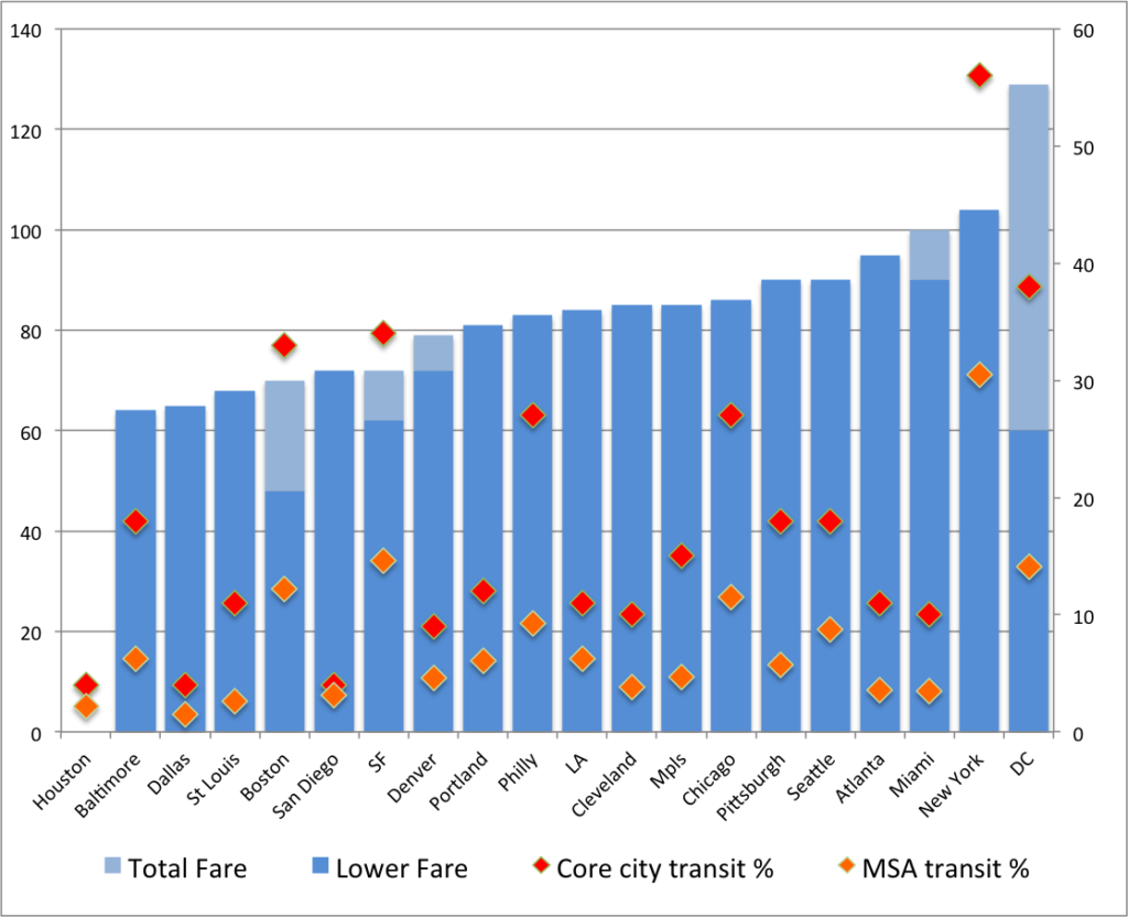
After the success of the Viaduc des Arts in Paris, some New Yorkers looked at their community and realized they had a somewhat similar asset, and didn’t really know what to do with it. Was the structure a blight—as it was seen by the Giuliani administration, which wanted to tear it down—or something worth saving? Like the Viaduc Des Arts, it was nearly 30 years between the abandonment of rail service and the opening of the structure to the public, but the results, in the month which it has been open, have been similarly positive.

The elevated railroad south from 34th street has an interesting history, following the use of the west side of Manhattan. It was first built, at-grade, in the 1850s. Along the Hudson were dozens of docks, and until the 1960s, New York was one of the busiest ports in the world. By the 1920s, the railroad across surface streets on the west side was the cause of so much congestion that a proposal was made to elevated the tracks south of the yards at Penn Station, and by 1934, the work had been completed: a two-track railroad (which was, in places, wider) extended for a couple of miles along the docks.

The line ended at the Saint John’s Park terminal, which was built in the 1860s, and rebuilt once the elevated line was completed. The complex stood near the current Canal Street IRT and IND (1 and ACE) subway stations, a few blocks east of the Hudson. The rebuilt station truncated the line a bit, and it now ended at Spring Street, about a block east of the river—close to the docks—although it retained the name. The facility was impressive, with nearly a million square feet of floor space, eight railroad tracks, dozens of truck bays, customs offices and a connection to the docks. Speed would be improved as well; before the grade separation, trains were limited by law to six miles per hour and had to be preceded by a man on horseback. The New York Central published a pamphlet extolling the virtues of the new line.

In addition to the services to the docks, the line served factories and, especially, the meatpacking district, encompassing more than 250 slaughterhouses. The New York Central touted the relationship of the line to destinations by both ship and railroad (assuredly because they were the only possible provider of service) for factory locations, and, indeed, several were built, some of which straddled the line. During World War II, the line was used heavily to service these various industries. Within 35 years, it would be abandoned.

The decline of the West Side Line was not only attributable to the automobile, although it definitely had an effect. With automobiles and trucks, of course, production no longer needed to be as centralized. In other words, it didn’t have to be on the island of Manhattan. In addition, trucks could more easily make deliveries to Manhattan (although it is still notoriously hard to deliver goods to the island, even the milk in The City expires earlier than elsewhere, due, ostensibly, to longer periods when it is out of refrigeration during transport).

But there were other factors at work in the demise of the Line peculiar to it (many railroads in the country saw major declines with the coming of the car and truck). One was the improvements made in refrigeration. In the first half of the 20th century, meat processing was best done as close to the point of consumption as possible, as refrigeration was rather rudimentary. However, major strides were made in refrigerated trucks and rail cars that by the end of the war, it was easier to process meat outside the city and ship the smaller product—just the meat—in. Thus, of the 250 slaughterhouses which once operated in the meatpacking district, only a couple dozen remain.

The other factor at work was containerized shipping. In “The Box” Marc Levinson details how shipping was extremely inefficient and costly after World War II, especially in major break-in-bulk points like New York City. Shipments would arrive on trains and have to be unloaded, sorted and then reapportioned in to ships for overseas travel. Improvements in efficiency were frowned upon, especially if they would cost the union jobs. New York still accounted for a good deal of shipping until the advent of the container. Within 20 years, the New York docks were moribund, as shipping had shifted to locations which could process metal containers, which were easily lifted from trains and truck to ships. The Saint John’s Park Terminal, at the cutting edge of integrated shipping little more than a generation before, had outlived its usefulness. Factories closed up shop, and the meatpacking district became a den for prostitution, transvestites and others seen as socially undesirable.

It was about the same time that the railroad ceased to be used—the last three carloads were delivered in 1980 and it fell in to disuse. Local residents lobbied for it to be torn down in the 1980s, and it may well have been, had the city not been in such dire financial straits that a demolition and environmental cleanup were not in the cards. By the time the city was solvent enough to tear down the structure, in the 1990s, a small group of devotees and urban explorers—loosely organized as The Friends of the High Line lobbied against its demolition. Thus, while portions were torn down, it was kept intact north of Gansevoort Street. Some of the explorers of the structure, such as Joel Sternfeld (whose book of images from the line is now out of print and fetches high sums on the open market) introduced the structure to the masses, and Giuliani was unable to knock it down. Michael Bloomberg was more supportive of the project, the neighborhood through which the line runs had transformed from a den of vice to one of the trendiest parts of town, and fundraising began to open the structure to the public. The Design Build Network has a good history and description of this time frame of the structure.

Reaction to the project has generally been quite positive. The main detractors have not been those who wish it away, but those who lament the loss of the frontier aspect of the previously wild viaduct. Before it was completed, the High Line was open to a select few who climbed atop it, and wandered through a veritable prairie that was growing up in the middle of Manhattan. The current design tries to incorporate such aspects, keeping some of these plants and portions of the abandoned track, but with demarcated walkways and thousands of visitors, it is a different space entirely. Still, it was not feasible to let the structure rust in to oblivion, and keeping it as a public space is surely preferable to tearing it down, and having the landscape become a sea of condos like any other in New York.

The High Line opened to the public last month. I have not been in New York City since, but it is most definitely a destination the next time I am there. It seems to be similar, at least in the above, to the Viaduc des Arts, although more minimalist in design. How it will continue to interface with the city in the future will be interesting: it is one of the less-developed parts of Manhattan, and still has a few undeveloped parcels facing the High Line. Whether these will ever open out on to the structure is questionable: it’s a rather controlled space (one that is closed at night, for example). Also interesting will be what happens underneath it. Still, it is one of the most exciting new public spaces in New York in some time.

(Part of an occasional series.)

Viaducts: in with the old

Recent travels have taken me to Chicago, San Francisco and Paris (and explain the lack of activity on this page). It is the latter of these cities which I am going to use to explore the above-city landscape.

What is the above-city landscape? Well, in the late 1800s and through much of the 1900s, cities realized that it was generally quite easy to build transportation networks above street level. The first of these took the form of steam-powered, elevated railroads. In most cases, these were built on metal structures above the street, but in a few, they were built as stone or masonry structures instead. The next generation were electrically-powered elevated railroads, which were mostly built in the early 1900s and, in many cases, torn down during the latter half of the 20th century, which were followed by, after 1950, mostly concrete elevated road structures.

Most of these structures, especially the narrower, non-road ones, were built over existing roads. (Road structures are often several lanes wide and required significant property takings, as there were no existing rights of way wide enough to carry them.) Thus, when they fell in to disuse or when they were made redundant by paralleling surface or underground routes, most were seen as a blight to the landscape and torn down. Metal, over-street elevateds are easy targets: they are ugly, they block light, they generally carry noisy traffic and their supports impede the flow of traffic. If they no longer serve a purpose (such as carrying passengers) there is usually little debate as to their fate. Abandoned elevateds are a rare sight indeed.

In a some cases, however, elevated railroads were not built over a street, but next to it, or in between streets. Examples of this type of construction include some active lines, such as the Park Avenue Viaduct in New York, the Reading Viaduct in Philadelphia and various elevated lines in Chicago (the Red Line north of the Loop and the Blue Line east of Logan Square). Quite often, however, segments of urban, elevated lines have been abandoned, for various reasons: a new at-grade or (more often) underground segment opened, their need was made redundant by a parallel line, or the need they served ceased to exist. Once this occurs, cities are left with long, grade separated rights-of-way, and no clear procedure for what to do with them.

Urban viaducts are often seen as a blight, and while they do represent significant infrastructure, there is often pressure to tear them down. In Boston, no one could wait to get rid of the Central Artery—there was almost no discussion of keeping it for any reason. Although it could have been used as an elevated park or a means to connect North and South Stations, consensus was to remove it and reconnect the city to the waterfront. This was likely the correct approach; the structure was close to 100 feet wide and ran between the city and the harbor, casting an ominous shadow.

In some cases, however, disused structures are less abhorred and there is not such swift pressure to demolish them. This, in particular, is the case with railroad structures. Few, if any, highway structures in cities are less than six lanes wide—if you are going to bother building an elevated highway and the various accoutrements which go with it (exits, entrances, underpasses, and such), it makes little sense to build it as a two-lane roadway. A two lane roadway can not handle much traffic, and the marginal cost of adding a few extra lanes is relatively small. Thus, highway bridges tend to be at least six lanes wide, and with shoulders, barriers and supports, they are often 100 feet wide (add a couple of exit ramps and they are even more intrusive). Furthermore, because the roadways need to be accessed from below, these structures are usually built at a minimum height above other streets, often providing less than 20 feet of clearance. Thus, highway structures tend to create large and dark spaces underneath, which are almost universally disliked.

Railroad structures, however, often are built differently. Height is less of a consideration, although elevated structures are usually not built any higher than necessary. However, width is much less of an issue. Highways need to be built to a considerable width because the capacity of a highway lane is only about 2000 persons per hour. One railroad track, however, can carry ten times that many people (trains carrying 1000 passengers and operating at three minute headways are commonplace), so in most cases, no more than two tracks are needed. In a few cases, three tracks are built to allow for extra capacity, and sometimes even four—although since the entirety of Grand Central Station can be served by four tracks, wider structures are rarely necessary. And since railroads don’t need breakdown lanes, exit ramps or barriers, elevated railroad structures are rarely wider than about 40 feet, and often only 20 feet from side to side. These structures are not as often seen as the “Chinese Walls” that highways (or railroads built entirely on fill) are compared to, and therefore not universally torn down when they are no longer in use.

While aerial structures have been abandoned for some time, there is not yet a definitive protocol for what to do with them. Some, of course, are torn down and, often, the rights of way are used for new structures, all but obliterating the previous use (except to the well-honed eye). For instance, the CTA in Chicago demolished several short elevated segments, such as the Humbolt Park Line (the only visible traces of which lie in buildings which end suspiciously short of nearby alleys) and the north end of the Paulina Connector (redundant once the State Street Subway was built), which is only visible where the structure is still used for railroad signals.

More recent closures, however, have not necessarily been followed with demolition. As cities have transformed, planners and residents have realized that there is potential to use old viaducts to create unique urban spaces. Demolishing such structures often leave narrow and sometimes-bizarre plots of land which are not conducive to new development (especially when they are less than two dozen feet wide), so the land does not have much intrinsic value. However, the structures are often quite sound (having often been overbuilt) and seen as opportunities to bring green space in to the city—without demolishing the structure. The two most significant examples of this type of reuse are the Viaduc des Arts / Promenade Plantee in Paris and the High Line, which very recently opened in New York City. We’ll explore both of these in an occasional series.

Tracing transportation epochs

I was in Rochester, New York this weekend for my sister’s college graduation and finally got to see a bit of the city. (My previous trips there were a crash on a road trip to Chicago that had started off with a three hour delay twenty minutes outside Boston from an accident and a trip in 2006 which was mainly involved with skiing north of Syracuse; Rochester is a bleak place in early December anyway.) From a urban planning point of view, Rochester has some interesting sights, such as the at grade crossing of the Erie Canal and Genesee and the high falls in town. I also liked the fact that I flew from Rochester, once the leading flour milling city in the country, to Minneapolis, which succeeded it as the leading flour milling city in the country.

But the most interesting bit I saw was the old Rochester Subway. One of very few subways to be abandoned, the Rochester line ran similar to Boston’s Green Line, with surface lines feeding in to a subway. However, only a bit was actually underground; most of it was built on the old bed of the Erie Canal, which actually crossed over the Genesee in downtown Rochester. When the canal was relocated south of town, it was converted in to a grade-separated streetcar line, what we might today call light rail. Downtown it was covered by Broad Street, including across the Broad Street Bridge. Usage of the system peaked by World War II, but fell with suburbanization, and by 1956 the subway was abandoned. Most of it then became the right of way for Interstate 490 in to town.

The Broad Street Bridge in Rochester, with the lower level, previously the canal and subway, now abandoned. (“Rochester NY Broad Street Bridge 2002” by Andreas F. Borchert – Self-photographed. Licensed under CC-BY-SA-3.0-de via Wikimedia Commons.)

There’s a lot of good information about the subway at RocWiki and there’s a good reference Google Map of the subway, too. Also of note are the USGS topographic maps from 1920 of the city, particularly the southeast and southwest portions of the sheet, which show the pre-Subway configuration, with the canal bypass of the city under construction.

As a geographer, amateur planner and a bit of a history buff, I like how one single section—by Court Street and South Avenue, between the library and the river. From 1822 to 1926, the bridge there served as the Erie Canal. From probably the late 1800s to the mid 1900s, the the station for the Lehigh Valley Railroad was operational (it still stands). The main player in town, the New York Central, had a station to the north. From 1926 to 1956, the site was served by the Rochester Subway, and from the mid-1960s to the present it is next to Interstate 490. To the west is, from what I know, the only canal to be converted to an electric railroad to then become a highway, with no major gaps or other uses in between. Thus, the site is represented by four of the five main travel modes of the country’s history: canal, rail, electric rail and automobile. It’s missing just an airport, and I doubt that will ever be built there!

A professor called John Borchert came up with several periods—or transportation epochs—of the development of transportation in the United States. They generally begin with the beginning of prevalence of a certain technology. These epochs, and various transportation milestones in Rochester, can be compared below: