Google Maps has some work to do on route hierarchy

Last week we examined some of the changes—many of which I think are positive—to the Google Maps interface. However, Google Maps has fallen in to an old trap which harms the overall product: they unilaterally classify US Routes as a higher status road type. This leads to maps where some minor roads appear to be highways, while other routes with higher capacities and uses, appear to be smaller roads.

First, a case from west of Boston:

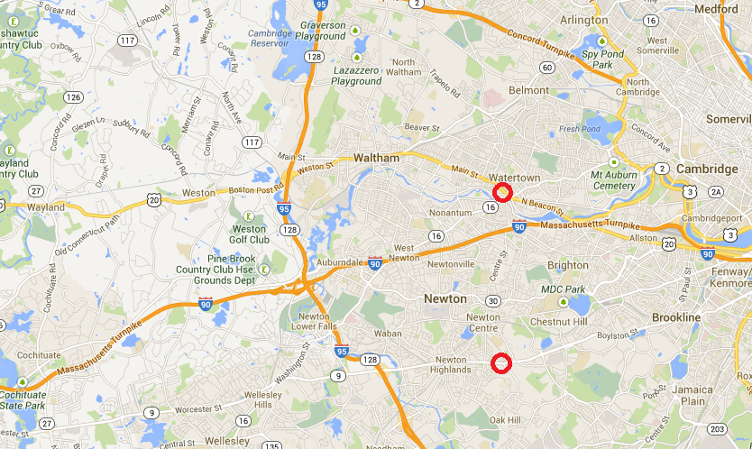
The two red circles on the map above represent the locations of the photos below. Which is which?

It would make sense for the highway on the left would be shown with a higher symbol level than the city street on the right. This, however is not the case. The image on the left (both from Streetview) is of Massachusetts Route 9 in Newton, showing a typical section of this divided highway. The image on the right shows a typical section of US Route 20 in Watertown, a mostly two-lane city street. Note on this map the second-level (lighter orange) roadways. They are few in number, and therefore quite prevalent. Thus, you would think that they are major, not-quite Interstate-level highways. So if you wanted to avoid the Turnpike (I-90) you’d be right in thinking that Route 20 is a viable alternative.

If Google Maps is going to make these changes, they should review the actual functionality of each roadway to properly classify them based on speed and capacity. Simply labeling every US highway as a higher category of roadway is folly.

It’s helpful to touch on the history of the US Highway numbering system in discussing the use of US Highways today (there is a good article on Wikipedia). The system was put in to place in the mid-1920s, so it is nearly a century old. Before that point, most roads were named (often as Auto Trails), although many of these names were of routes which were not improved; US Army convoys in 1919 and 1920 averaged only about 30 to 60 miles per day (not per hour; per day). The US Route numbering system was more of a way to codify these names across state lines (as New England had done a few years earlier; which is why many state highways in New England retain their number when crossing state lines) than to build improved highways.

So Route 20 was numbered in 1926, having previously been New England Route 5. Route 9 was originally the Boston-Worcester Turnpike, and was rebuilt in the 1930s when streetcar operations ceased, becoming one of the earliest roads in New England with some grade separation. (It has barely been improved since; it still has steep grades and some traffic lights. Of course, neither has Route 20.)

Thus, Google Maps, in 2013, is basing much of its route hierarchy on a numbering system put in to place nearly a century ago. Not only does this make little sense, but it harms the usability of its mapping interface.

Station Name Creep

Jarrett Walker tweeted today about a piece he wrote a few years back on his blog regarding corporate naming for train stations. While I agree that it is a pretty dumb idea to have mindless corporate naming rights (“get on the train at Bank of America, change at Gillette and get off three stops later at Novartis”), station names in Boston have changed, rather drastically, over the years. Someone dropped in from 1950 would barely recognize station names today, even though the lines in the core of the city haven’t changed in the past 50 years. So, where appropriate, I think name changes are not the end of the world, and if they help direction finding without overly-lengthening the name, may help.

Here’s a quick rundown:

Haymarket was originally Union-Friend, named for nearby streets. It was extensively rebuilt in the 1970s. (Wikipedia)

Government Center was originally Scollay (and Scollay Under for the Blue Line), named for the square above. It was obliterated by the Government Center construction in the 1960s (when the line was rerouted and the neighborhood leveled. (Wikipedia)

Hynes was originally Massachusetts, named for the Mass Ave. It then changed to Auditorium, then to Hynes Convention Center-ICA and, when the ICA moved, to Hynes Convention Center. During automated station announcements, the announcement sounds choppy at the end, as they just clipped the audio file when the station was renamed. (Wikipedia)

Prudential was originally Mechanics, named for the meeting hall which stood nearby, and changed when the Pru was built in the 1960s. (Wikipedia)

Kendall and Charles have both been modified to Kendall-MIT and Charles-MGH over the years.
Downtown Crossing was originally Washington, Winter and Summer. This is one of several Orange Line stations which has offset platforms named after multiple streets (and Washington was named after Washington Street of course). The Orange Line came first here, and the station wasn’t renamed to a single transfer point until 1967, when Winter and Summer were dropped, and 1985, when it as changed to Downtown Crossing. So although things didn’t change from 1944 to 1965, Tom Lehrer’s Subway Song today would be out-of-date. (Wikipedia)
Washington Street was originally the only street along Boston Neck and carried the Post Road to New York. As the main street, intersecting streets changed names when they crossed Washington (which doesn’t help the whole Boston is impossible to navigate thing). And because the BERy named subway stations for their intersecting streets, different platforms got different names (the Washington Street Subway had no center platforms). So, Friend-Union, Winter-Summer and …
Chinatown was originally Boylston and Essex. Boylston on the southbound side, Essex going north. Was it a problem that there was a separate Boylston station a block away? Apparently not. (Wikipedia)
State was originally Milk and State on the Orange Line and Devonshire on the Blue Line. It was, for a time, actually called State/Citizens Bank as Citizens was trying to get the whole area renamed for them, but that lapsed and the name reverted to State. (I don’t think any system maps were ever displayed with this travesty of a name.) State was probably retained over other names because it is located at the old State House, in addition to being on State Street. Along with Park, it is the only main transfer station that hasn’t been renamed completely. (Wikipedia)
Aquarium was originally Atlantic (for the Avenue, not the ocean). 
There’s a good animated GIF of the changes over time here.

Tracing transportation epochs

I was in Rochester, New York this weekend for my sister’s college graduation and finally got to see a bit of the city. (My previous trips there were a crash on a road trip to Chicago that had started off with a three hour delay twenty minutes outside Boston from an accident and a trip in 2006 which was mainly involved with skiing north of Syracuse; Rochester is a bleak place in early December anyway.) From a urban planning point of view, Rochester has some interesting sights, such as the at grade crossing of the Erie Canal and Genesee and the high falls in town. I also liked the fact that I flew from Rochester, once the leading flour milling city in the country, to Minneapolis, which succeeded it as the leading flour milling city in the country.

But the most interesting bit I saw was the old Rochester Subway. One of very few subways to be abandoned, the Rochester line ran similar to Boston’s Green Line, with surface lines feeding in to a subway. However, only a bit was actually underground; most of it was built on the old bed of the Erie Canal, which actually crossed over the Genesee in downtown Rochester. When the canal was relocated south of town, it was converted in to a grade-separated streetcar line, what we might today call light rail. Downtown it was covered by Broad Street, including across the Broad Street Bridge. Usage of the system peaked by World War II, but fell with suburbanization, and by 1956 the subway was abandoned. Most of it then became the right of way for Interstate 490 in to town.

The Broad Street Bridge in Rochester, with the lower level, previously the canal and subway, now abandoned. (“Rochester NY Broad Street Bridge 2002” by Andreas F. Borchert – Self-photographed. Licensed under CC-BY-SA-3.0-de via Wikimedia Commons.)

There’s a lot of good information about the subway at RocWiki and there’s a good reference Google Map of the subway, too. Also of note are the USGS topographic maps from 1920 of the city, particularly the southeast and southwest portions of the sheet, which show the pre-Subway configuration, with the canal bypass of the city under construction.

As a geographer, amateur planner and a bit of a history buff, I like how one single section—by Court Street and South Avenue, between the library and the river. From 1822 to 1926, the bridge there served as the Erie Canal. From probably the late 1800s to the mid 1900s, the the station for the Lehigh Valley Railroad was operational (it still stands). The main player in town, the New York Central, had a station to the north. From 1926 to 1956, the site was served by the Rochester Subway, and from the mid-1960s to the present it is next to Interstate 490. To the west is, from what I know, the only canal to be converted to an electric railroad to then become a highway, with no major gaps or other uses in between. Thus, the site is represented by four of the five main travel modes of the country’s history: canal, rail, electric rail and automobile. It’s missing just an airport, and I doubt that will ever be built there!

A professor called John Borchert came up with several periods—or transportation epochs—of the development of transportation in the United States. They generally begin with the beginning of prevalence of a certain technology. These epochs, and various transportation milestones in Rochester, can be compared below: