Ten years after I enroll, Macalester’s transit is slated to improve

Ten years ago, I arrived in Saint Paul, Minnesota as a (n extremely awkward 18-year old) first-year college student at Macalester College. Recently the college tweeted that new students could follow the campus life account and hash tag to stay abreast of move-in information. This made me feel old: when I moved in, we didn’t have hash tags. Or Twitter. Or Gmail. And forget about smart phones; many of us didn’t even have regular phones. And the Spotlight was an anticipated publication because it had everyone’s picture and phone number. In print form. Three years later, it would be fully supplanted by Facebook (which was based on a series of similar publications at Harvard).

Some things, however, have not changed. The 63 bus still bisects campus on Grand Avenue, and the 84 still runs north-south along Snelling Avenue. Even so, the public transport options from Macalester to the rest of the world (beyond the “bubble”) have changed in the past ten years, and are about to change exponentially. The two bus routes which serve campus will still follow their streetcar predecessors’ routes, but new rail lines will finally give them more flexibility and greatly enhance service.

Public transit lines can be very slow to change. They are rooted firmly in history; in most cities bus lines are based on streetcar lines built around 1900, and this entrenchment is not frequently updated to reflect more modern travel needs. For instance, the 63 bus runs west from Macalester and dead-ends at the University of Saint Thomas a mile to the west. This is the same route it’s run since 1890. (The only changes have been in headways, which have varied between 15 and 30 minutes over the last 10 years.) It connects there with one spur route of the 21, although it’s not timed, so except to get to Saint Thomas, there’s little reason to take the bus west. In 1900, the neighborhood was focused on Saint Paul, and ridership was mostly to downtown. Now, with Minneapolis a major draw, the bus provides very little connectivity to the west, instead dead-ending at an unheated bus shelter with a single transfer.

The 84 is slightly-more updated. By 2002, it had shed it’s streetcar-era jog up Pascal and moved to a full run on Snelling. (It also shed it’s Saint Paul-specific route number in 2000 or so, when the bi-city numbering scheme was integrated.) In 2000, it had several branches, and the airport branch was only served every hour-or-so, providing quick but infrequent access to MSP. (This was dramatically improved by 2002, when, during the heyday of Macalester-airport connectivity, there was an airport-bound bus twice an hour and the single-seat trip took under 30 minutes.) In 2004, when the Hiawatha Light Rail line opened, the route was changed to provide connections to the train and thence the airport, increasing travel times (especially with the moronic Montreal loop, which adds an out-of-the-way mile to the route with no appreciable gain) and no additional airport-bound headways, although the other half of the buses do connect to the airport-bound 54 bus which makes a tolerable airport connection every 15 minutes.

As much as that particular route has devolved, connectivity to the light rail and Minneapolis has improved for the 84. And with the new line on University finally being built, Saint Paul in general, and Macalester in particular, is going to reap dramatically improved transit access.

To the south, the 84 will see an increase from four to six buses per hour. The Montreal loop will be eliminated, shaving several minutes from the Snelling-Hiawatha trip. Headways on that branch will not be improved, however, so connections to the Hiawatha Line (Apparently, the Hiawatha Line is going to become the Blue Line, and the Central Corridor the Green Line. It’s probably good—unlike Hiawatha, “Central Corridor” is a pretty horrid name for a transit line, but I’m still not used to it.) will not be improved. This is too bad, and hopefully the short-turn trips at Ford Parkway could be extended across the river. Still, there is an improvement in frequency to Ford Parkway, and an improvement in time to 46th Street, both of which are gains. (In comparison, when the Hiawatha Line opened, there was no improvement in headways coupled with a loss in travel time.)

To the north, the 84 will serve its current route, but do so 50% more often. In addition, at some point it might become a “rapid bus” service and eliminate many single-patron stops, speeding the route mightily.

To the east there will be no net improvement in weekday headways, although the renewed emphasis on the 63 bus will likely mean less of a likelihood of headway reductions in the near future. (In 2001, headways were 15 minutes on the route west of Downtown, in 2003 they were expanded to Sunray, in 2005 they were reduced to 30 minutes West of Downtown and in 2009 they were finally made 20 minutes on both sides of the route.) And the weekend headways, which are currently 30 minutes on Saturday and an hour on Sunday, will be improved dramatically.

Finally, to the west, the most improvements occur. Right now, outside of rush hour, travel to Minneapolis is a trip on the 84 and a transfer to the express-bus 94 (30 minute frequencies outside of rush hour) or the 16/50 (10 minute headways at least, but horrendously slow service. The light rail will halve scheduled times, and with the 84 matching its headway, the average connection at Snelling and University will be 5 minutes in both directions. The average trip time will be 30 minutes from Macalester to Nicollet, as fast as the current connection but with no traffic delays at rush hour and triple the frequency middays.

In addition, the 63 bus will provide service west and a connection to the light rail. So, from campus, there will be 9 options per hour to get to Minneapolis, and a quick wave of the smart phone will tell you which bus is slated to arrive next. If an 84 is 9 minutes off but a 63 is due in 2, walk to Grand. If the 63 just passed, grab an 84. Coming back, if you can make a quick connection at Raymond to the 63, hop on it; otherwise, stay on the train.

When I was on campus, I rode the bus east with some frequency to Saint Paul (15 minute headways and a 15 minute ride) but rarely ventured to Minneapolis. When I lived in Saint Paul, headways on the 63 were worse and there were still no good connections to Minneapolis, so I spent a lot of time bicycling. I’d still probably bike for this trip with the Central Corridor plan in place, but I can think of multiple times where I decided not to take a trip to Minneapolis because the weather was lousy and the bus schedules uncooperative. Having improved headways to all points of the compass will be a boon for Macalester students, and a boon for the residents of Saint Paul. Hopefully they’ll be enticed to come out and use it.

When streets were streets

About a week ago, Infrastructurist posted about the various materials used for sidewalks. The consensus is that concrete is cheap and functional if not very environmentally friendly (both in its construction and its low permeability). Of course, in Paris, the streets are cobbled, which is beautiful, if a bit jarring to drivers and cyclists (although perhaps better than potholed asphalt).
Now, in America, except in a few instances (historic districts, or places where rich people gather, or both), streets are pavement. In some cases, concrete. Pavement is good when it’s good, but when it’s bad, it’s real bad. In other words, asphalt seems to have a wide range of conditions: new asphalt is silky smooth, but it doesn’t last in good shape. For a while it’s tolerable, until there’s a year with a lot of freeze-thaw cycles and gaps, gashes, frost heaves and, yes, potholes take over.
And that’s where we are in the Twin Cities. We’ve had an about-normal winter, but it’s been marked by a decent amount of warmer and colder temperatures. And snow. And plows. Minneapolis had enough snow accumulated that they had to ban parking on one side of narrow streets to allow traffic to flow, and all over there are huge gaping holes in the streets. And that’s meant we get to see what lies beneath.
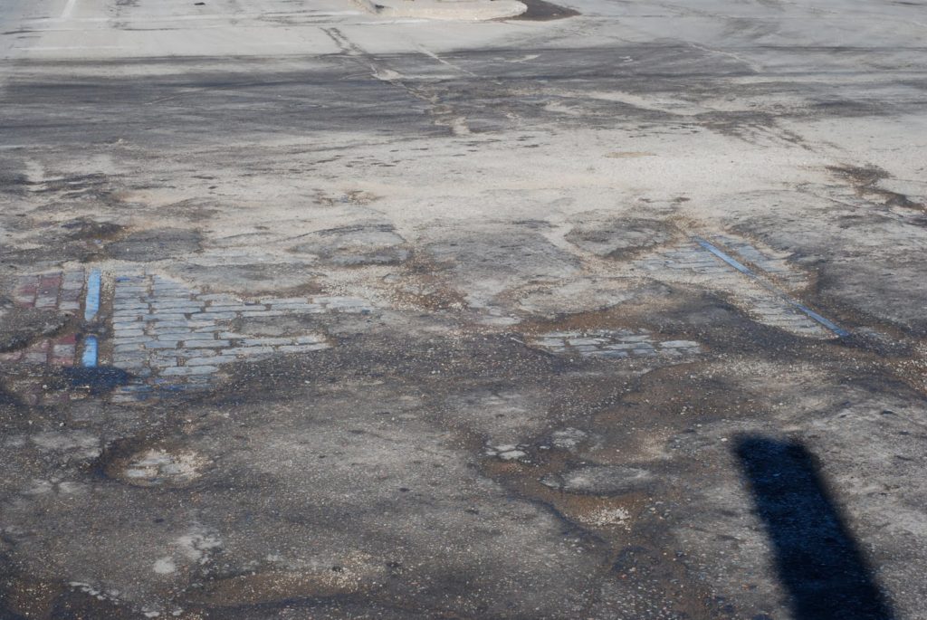
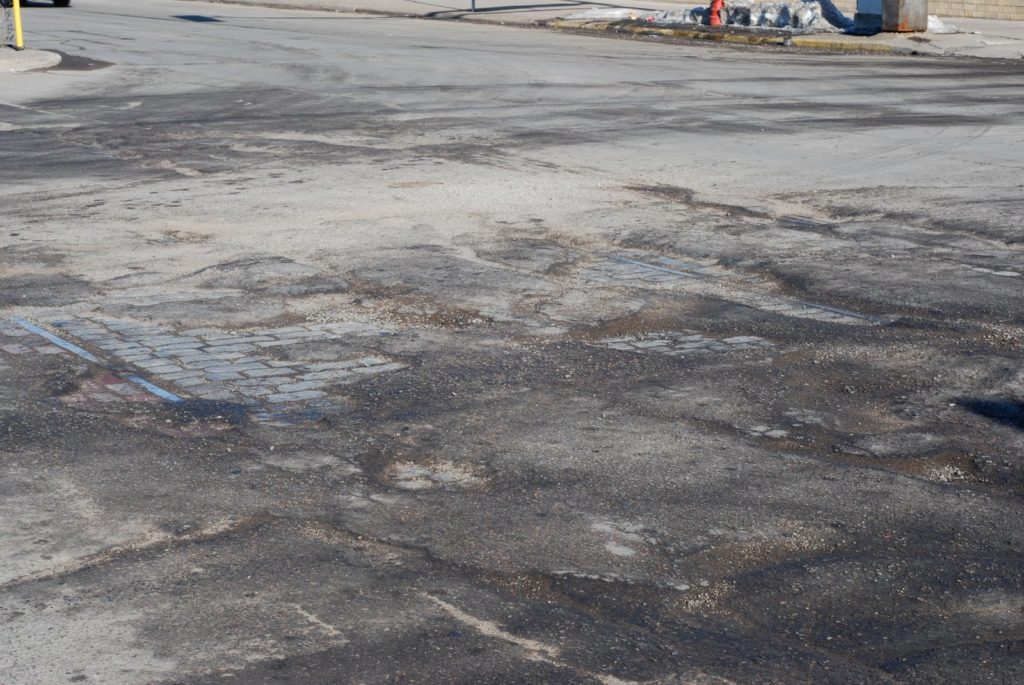
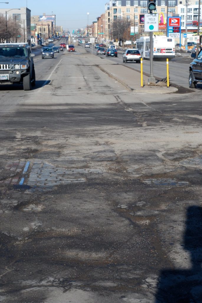
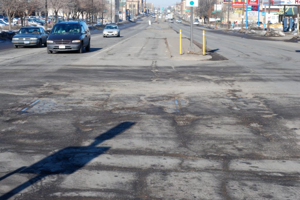
Here’s the middle of the intersection of University Avenue and Vandalia Street in Saint Paul. University was once the main thoroughfare between Saint Paul and Minneapolis, and while most traffic now takes the paralleling I-94, it is home to buses and will, in a few years, be home to the Central Corridor Light Rail. Of course, University had a streetcar line, which was very well patronized (the buses still run at 10-plus minute headways, with limited service at rush hours) until it was closed in favor of buses in the early 1950s. 
But 55 years later, the streetcar tracks, at least, are making a (re)appearance. The Google Street View from a couple years ago shows solid pavement at the corner of Vandalia and University. However, Vandalia is the route to the interstate for many trucks serving the nearby industrial area, as well as going to a large BNSF multi-modal facility, and the corner sees a lot of heavy traffic. So with the current winter, the pavement has been torn up pretty well.
It’s actually not bad to drive on—the holes are wide enough that they aren’t all that deep (the sides generally slope) but so much pavement is gone that you can see the streetcar tracks as well as the pavement. And it’s really quite interesting. First of all, for such a wide road, the streetcar tracks really take up a small amount of room. The image above shows that the tracks are contained in a lane-and-a-half of a turn lane and median (no comment on how ugly the University streetscape is), and there are two lanes of traffic and a wide parking lane on either side.
But second, it gives us a really good idea of what streets used to look like. Here’s a closer-up look at the exposed section. The rail on the left is the southern rail of the eastbound track, the rail visible to the right is the southern rail of the westbound track. So, between the tracks were (are) gray cobblestones, and on the outside red brick. There isn’t much color film from the time, but it seems that University, with red and gray stone and silver, steel rails would be almost elegant (some trees would be nice as well). Now, with gray, gray and more gray, it’s quite drab.
Apparently bricks and cobbles don’t hold up well to heavy truck traffic, although this section seems to be doing just fine. Apparently bricks and cobbles were used along streetcar routes because they could be more easily picked up and laid down when track work was necessary. Of course, there’s a possibly apocryphal tale that Melbourne, Australia’s trams were saved when, in the ’50s, the tracks were set in concrete, so that ripping them up would be prohibitive (in the US they were mostly just paved over). The union’s intransigence there—they required two-man operation on buses, and streetcars had conductors until the 1990s, when their removal caused a crippling strike (long story short: government says “one person tram operation”, union says “no” and runs trams without collecting fares, government plans to cut power to the system, union drives trams on to streets in city center, where they sit for a month)—was probably more to blame.
When Lake Street was rebuilt in Minneapolis in 2005, the street below was in similar shape—shoddy asphalt over a firm streetcar base. Since it was not just repaved, it was dug up completely, and Twin Citians flocked to scavenge bricks from below. University, which is wider and longer than Lake Street, should be a field day for anyone who wants a new, free patio or walk—it will be fully rebuilt for the light rail line (yes, they’ve studied it, and they can’t just reuse the tracks already there).
But, why not build streets out of these materials again? The upside to pavement is that, for a while, you have a really nice road. But in the long run? You have ruts, dips and potholes. Another layer of pavement is a panacea; cracks almost always form where there were cracks before (it’s easy to find old streetcar tracks—they’re wherever there are parallel cracks running down the road). Bricks and cobbles are attractive and permeable. Water filters through, which is better for the environment. As long as there’s no heavy truck or bus traffic, they’re fine. If something goes wrong, it’s easy to make small repairs which actually last (as opposed to patches which tear out during the next thaw). And for cyclists, constant cobbles are almost better than old pavement with huge potholes and ruts, even if you have a good bunny hop.
I’m not saying it’s the way to go for every street, but in certain cases—especially if there are streetcars involved, red bricks and granite pavers may be the way to go. And in many cases, they may be lurking just below the surface already.

The Central Corridor: a primer

One of my long-term projects, and when I say long term I mean long term, is to photograph the Central Corridor—between Minneapolis and Saint Paul—block by block, at various stages during its construction. I’ll post some of the photos here, although I assume that the whole avenue will be something along the lines of 150 photographs, and I’ll probably host those separately. I’m waiting on a wider-angle lens (24mm) which will let me more easily convey the street, especially considering its width in Saint Paul. It is my hope that, once the project is completed, photos can be taken from the same spots in the future for a before-and-after effect.

But before we dive in to a look at the Central Corridor—as it now stands—it would be helpful to have a quick (ha) primer on its history and some of the controversy towards bring fixed-guideway transit back to University. It helps to go all the way back to the founding of the Twin Cities. The area was inhabited by the Mdewakanton, a band of Dakota, before western settlement, which began in earnest in the early 1800s (there were traders and explorers before then, but none stayed). Fort Snelling was set up on the bluff overlooking the junction of the Minnesota and Mississippi Rivers, and still stands, but settlement never concentrated there. Instead, two urban centers developed, each with a different purpose. Saint Paul was built at a bend in the Mississippi and was the northernmost port on the river—north of Saint Paul the river enters a deep-walled gorge and a 50-foot waterfall—not conducive to navigation. With steamboats as the main transportation mode of the early- and mid-1800s, the city prospered.

Minneapolis, too, did quite well. While Saint Paul was the northernmost (or, perhaps, westernmost) connection to the east, Minneapolis became, in a way, the easternmost connection to the west, because it had something almost no other city in the Midwest had: water power. Between the Appalachians and the Rockies, there are many large rivers branching off from the Mississippi (in addition to the big river itself), many named after states: the Minnesota, Wisconsin, Illinois, Missouri, Ohio and others. Most of these, however, ply the plains, and, if they fall in elevation do so gradually. Not so for the Mississippi north of Saint Paul. After running in a wide, flat valley for its length, the old glacial outflows which provide that valley—the Saint Croix and Minnesota—diverge and the current main river climbs up through the gorge. Originally, the river fell over a ledge of limestone near the current confluence, and slowly crept north, eroding a few feet each year. This was stopped by the damming and control of the falls in the 1860s, although not for navigation—but for 111 vertical feet of water power. From across the growing wheat fields of the west, grain was shipped to Minneapolis to be milled and shipped east—where else was there available power?

(As an aside, it is often said that Saint Paul is the westernmost Eastern city and Minneapolis is the easternmost Western city. Saint Paul has narrower streets and is hemmed in by topography; most neighborhoods are up on hills. Minneapolis, on the other hand, is above the river, and spreads out across the plains. Perhaps this is a manifestation of from where the cities drew their influence.)

The Twin Cities are separated by about ten miles, and once railroads came in, there were services between the cities, the Short Line was built to help facilitate commuter-type services between the cities. However, while railroads have continued to play important roles in the Twin Cities’ economy even to this day (although less so than in the past), short distance passenger rail has not—the cities never developed commuter rail type services; those were supplied by streetcars. In 1890, the first “interurban” (so-called because it went served both Minneapolis and Saint Paul; it did not resemble a typical interurban) opened along University Avenue. The streetcars put the railroads out of the short-haul business between the cities, and within a few years the Twin Cities had a fully-built streetcar system service most main streets every fifteen minutes—or less. On University (and several other main lines) rush hour service was almost constant.

Low in-city density, little competition from mainline railroads, and relatively little crossover between the two cities (which generally had separate streetcar lines each focused on the downtown), however, meant that there was never impetus to built higher-speed or higher-capacity transportation. With the infatuation with buses of the 1950s, the Twin Cities were quick to rip up the streetcar lines, even where patronage was still high on some lines. Yes, the were shenanigans with proxy battles and speculation about the involvement of General Motors, but even if they lines had continued in private ownership, there was little to keep them from being torn out, like most other cities in the country. The only cities to keep their streetcars had major obstacles in the way of running buses: Boston and Philadelphia had tunnels through their central cities which would not accommodate buses (and nearly all of Boston’s existing lines run on private medians), San Francisco had several tunnels and private rights of way on existing lines, the Saint Charles Line in New Orleans runs in a streets median (or “Neutral Ground”) and Pittsburgh has streetcar tunnels. In every other city in the country—and there were hundreds—the streetcars disappeared. There’s little reason to expect that the Twin Cities, looking at street rebuilds in the time of rubber tires, would have behaved any differently, even without the goons who made it the first major city to switch to buses.

Speculation aside, it would be fifty years until rail transit ran again. The Central Corridor, mostly on University, was the obvious choice for the first corridor, from both a macro-political and planning standpoint. Politically, the line serves Saint Paul, the capitol, the University of Minnesota, and Downtown Minneapolis. Planning, it serves a major transportation corridor with inefficient bus service, high ridership, and the ability to spur more development. Logistically, the line from Minneapolis to the Mall of America, via the airport, was a bit easier to build, on a cancelled expressway right-of-way. And after years of planning and machinations, it was.

Between the two downtowns, however, there is still only bus service. There are three options: the 16 runs every ten minutes, all day, every day. It is very, very slow. There are stops every block, and since it traverses low-to-middle income, dense neighborhoods, it often winds up stopping every block, often for only one or two passengers. Most of the day, the trip—little more than ten miles—takes more than an hour. There is no signal priority, no lane priority, and the bus is far too slow to attract ridership from anyone in a hurry. A second option, which runs mostly at rush hour, is the 50, which stops every half mile or so and runs about 15 minutes faster than the 16. Then there’s the 94, which runs express between the downtowns (with one stop at Snelling Avenue) every fifteen minutes along I-94, which is a few blocks south of University. However, it poorly serves the corridor itself, and is not immune to the rush hour congestion which builds going in to each downtown, often as early as 3:00 p.m.

In other words, there’s no fast, reliable transit connection along University between the Downtowns. The buses are crowded and slow. Despite frequent service, the avenue has a lot of land use poorly suited to its location between several of the major employment centers of the area. Closer to the University, it has been more built up, with some good, dense condo developments, but there are still huge tracts of light industry, unused surface parking lots, big box and strip malls and (mostly) abandoned car dealerships. Thus, it is primed for redevelopment, and, with the coming of fixed rail, will likely (hopefully) change dramatically, once the light rail can provide frequent service to both downtowns. The run time is scheduled to be 39 minutes, much of which will be spent navigating downtowns. Outside the downtowns, nowhere will be more than 30 minutes from either downtown, or the University, any time of day. It will be very accessible. And it will like transform the area dramatically. That’s why I want to photograph it before it all starts.

Next: The Central Corridor: controversy (or: “why is this taking so long?!”)