The new Harvard Bridge bike lane, animated-GIF style

The state, thanks in part to LivableStreets’ tireless advocacy, finally repaved the Harvard (/Mass Ave/Smoot) Bridge, and restriped the bike lane to a full five foot width. Previously it had narrowed to 20 inches at the foot of the bridge, which was substandard and dangerous. Now, it’s 5 feet wide, making it much easier to navigate on bicycle, and keeping the cars in the middle of the road. Here, in two pictures is the progress that was made:

In the animated GIF (on the right; give it five seconds), I didn’t perfectly take the picture from the same angle, so it’s not layered right on top (the “before” picture was taken the summer doing recon from a BS traffic stop). Note the location of the drain, and that while the bike in the “before” is closer to the drain, he’s outside the bike lane, while in the “after” the cyclist is further from the drain, but comfortably in the bike lane. Yes, at the edge of the frame is a Street Ambassador, the work of whom led to this better bridge. So that’s cool, too.

Also, the pictures were taken at 1:30 (standard time, November) for the after and 6:30 (daylight time, July) for the before, and the shadows are the same length.

Allston-Brighton toll straightening shouldn’t ignore Soldiers Field Road

Massachusetts has taken on a surprisingly progressive role in transportation policy in recent years, with the transportation secretary publicly stating that “we will build no more superhighways” and setting explicit goals for a shift away from single-occupancy driving. As part of this fix-what-we-have policy, the state is planning to convert the whole of the antiquated tolling system to open-road tolling, eliminating toll boots and charging vehicles based on transponders and license plates. This is a good step forward as it will not only reduce congestion at toll booths but also reduce the amount of land required by the serpentine ramps and plazas needing at Turnpike entrances and exits. While rural interchanges won’t be changed, it give the opportunity to rework a lot of urban land previously occupied by redundant roadways.

Nowhere is this more of an issue than at the Allston tolls in Boston. Here, the main trunk of the Turnpike loops around a now-disused rail yard, and a convoluted set of ramps feed on and off of it with four separate toll plazas. The state has announced a $260 million plan to straighten this interchange, which contains dozens of bridge spans in need of replacement. An early conceptual design has been announced that reduces the amount of land required and simplifies the roadways. While this is a good start, it ignores the space just beyond the interchange, namely, the confusing and dangerous interchange with Soldiers Field Road which is congested, a major impediment to bicyclists and pedestrians and which darkens a stretch of the Charles River with highway ramps and traffic jams.
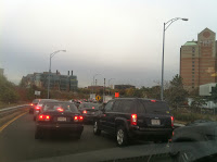
Typical traffic.

The Turnpike-Cambridge/River Street-Soldiers Field-Western Avenue interchange is a royal mess. It is so confusing that the state long ago stopped maintaining lane markings, and today it is a free-for-all as vehicles jockey for position as ramps funnel in to each other at a series of lights. For bicyclists and pedestrians? It’s a nightmare. Coming east on Cambridge Street is nearly impossible through the traffic chaos, and even crossing Western Avenue and Cambridge/River Street on the Paul Dudley White Bike Path is difficult, without a specific bike/ped cycle, crosswalks, curb cuts or even, at the southern bridge, a walk light!

A bit of a radical idea here that I’m proposing would be to move Soldiers Field Road away from the River. From Boston to Watertown, nearly the entirety of the Charles River is lined by highways. Yes, there is a bike path squeezed in between the riverbank and the roadway, but it is clear that cars are given the priority—we’ve turned our back on the river. The bike path is narrow, and when it intersects roadways crossing amidst the turning vehicles, it is perilous. It is a poor excuse for bicycle infrastructure, yet it is quite heavily used. Added to this, Soldiers Field Road doesn’t even follow a straight line but hugs the riverbank, adding distance (and pollution) for motor vehicles.

Here, then, is a conceptual plan to both improve the Turnpike interchange and the connection between the Turnpike, Soldiers Field Road, Western Avenue and River Street. Just doing the first part will still result in backups, congestion and pollution, and do nothing to improve the lot of pedestrians or cyclists. This plan would improve conditions for all users, and while it would require a major buy-in from Harvard University (which owns the land Soldiers Field Road would be rerouted across), they would be given a major incentive: an Allston campus connected directly to the river (in fact, some of their long-range plans have included decking over part of Soldiers Field Road). Depressing and covering the road would be simple compared to many similar projects (i.e. the Big Dig) as it runs almost entirely through post-industrial brownfields and athletic fields, no major property takings or utility work would be necessary, and much of the route would be closed to trucks, meaning the road clearance would only have to be big enough for emergency vehicles (and, perhaps, transit buses).

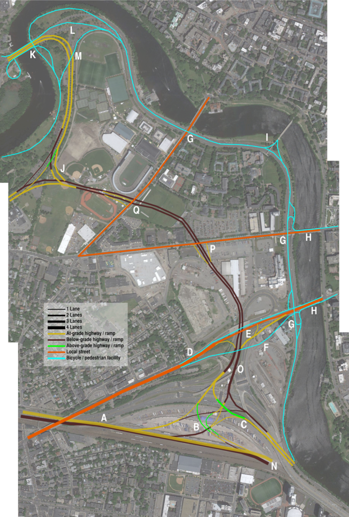
I’ve annotated the map, each letter corresponds to a comment below:

Click to make big!

A: The eastbound Turnpike main trunk would be depressed below the westbound trunk, allowing ramps to overlay.
B: A single westbound ramp would allow access to Soldiers Field Road in both directions, as well as River Street in Cambridge. Western Avenue would be accessed via Soldiers Field Road. Note that if Soldiers Field eastbound were merged with the Turnpike (see below), these ramps would be mostly below-grade; it could be built to allow that sort of conversion at a later time.
C: Soldiers Field east mainline. These roadways, and the ramps on and off of them, would not require truck clearances (but would require clear “no trucks” signage).
D: Cambridge Street could be narrowed to 4 lanes, and narrower yet between ramps. Sidewalks and cycletracks could be elevated to avoid ramp entrances and exits. Traffic from Western Avenue to Cambridge Street via Memorial Drive.
E: Offramp to Cambridge Street would end at a traffic signal.
F: Elevated cycletrack / sidewalk allows cyclists to avoid traffic signal and on/off ramps.
G: River bike path built 12+ feet wide, utilizes one of the disused Soldiers Field underpasses to avoid grade crossings. This would allow a 8-mile traffic-free trip from the Charles River dam west to the Western Avenue Bridge in Brighton by foot or bicycle. The other side of these underpasses would be filled.
H: Separated cycletrack facilites on the Western and River/Cambridge bridges would connected with the grade-separated riverside bike path. The riverside path could be set back from the riverbank, which would be maintained for active and passive recreation.
I: Rebuild the Weeks Bridge with ADA accessibility, and connect to bike paths for a river crossing.
J: The connection between Soldiers Field Road and the Eliot Bridge would be grade-separated; the current connection has a three-phase light in the center. Another option would be a single-point light between the Soldiers Field East-Eliot Bridge and Eliot Bridge-to Soldiers Field East which would reduce grade separation.
K: The current underpasses under the Eliot Bridge for bicyclists and pedestrians would be retained. Sidewalks / paths on the bridge would be used for grade-separated access to south-side pathways.
L: Most of the intersection east of the Eliot Bridge would be rebuilt as a wide swath of parkland.
M: A bicycle bridge would be built across the Eliot Bridge connection, cutting some distance off this route. Grade-separation would be integrated with the Eliot Bridge, and the current Eliot Bridge underpass would be retained (K).
N: Ramps to the current elevated structure would be built not to preclude future grade separation eastbound.
O: Mixing zones on Soldiers Field Road would be three lanes wide, and long enough to allow traffic to merge across two lanes to access various routes (although engineering would be required to determine the optimal length here so as not to bottleneck).
P: Ramps to Western Avenue would be built to specifications for truck traffic; north of this it would be cars-only. Traffic destined to Harvard Square would be routed west on Western and then east on Harvard, or via Memorial Drive.
Q: Ramps at North Harvard Street would be offset to keep construction away from Harvard Stadium. The track would be reoriented after construction.

While adding Soldiers Field Road reconfigurations to the rebuilding of the Turnpike interchange, the project should still not be viewed in isolation but rather as part of the larger transportation network. A few things to consider:

  1. Allowances should be made for future fixed-guideway transit between BU and Harvard.
  2. The entirety of the Turnpike, the railroad tracks and as many ramps as possible could be buried to allow the street grid to be connected across the rail yard from the BU area towards the river.
  3. Instead continuing east along the river, Soldiers Field Road could merge in to the Turnpike. This would require a wider highway (perhaps five lanes in each direction) and require the highway to be rebuilt below-grade to allow for room for the rail line. It would probably also necessitate some sort of exit in the Charlesgate area. This would be moving towards Big Dig territory as far as complexity, although by moving all rail service to North Station via Cambridge on the Grand Junction, enough space could be freed up to phase construction along the Turnpike. It would, however, create a three-mile-long section of riverfront with no roadway between the city and the river. (Paul Levy made this point years ago.)
  4. The Grand Junction, if (3) were built, would have to be fully rebuilt, below grade and with a transfer station at Kendall Square, although this would be a dramatic transit enhancement for the region and worth the investment.
  5. If Soldiers Field Road and Storrow Drive beyond it were replaced, it would recreate the parkland which James and Helen Storrow originally intended along the river. A two-lane parkway-type road could be retained from Charlesgate (which would have the Bowker Overpass flyovers removed) eastward (although this, too, could be in a tunnel) with a wider roadway resuming only past the current tunnel near the Hatch Shell towards Leverett Circle.
In other words, a project as large as proposed for the Allston Tolls should not be viewed in isolation, as its effects—good or bad—will cascade in several directions along the transportation network. With this kind of brownfield, simply rejiggering some onramps—and ignoring nearby bottlenecks and queues—is not enough.

How schedule adherence affects headways

There’s an article on TheAtlanticCities which is bouncing around the office about how painful it is to wait for a train (I’d add: especially if you don’t know when it might come). But even with the proliferation of countdown timers (except, uh, on the Green Line), any disruption to the published (or, at least, idealized) headways can cause headaches. And when headways get at all discombobulated, passenger loading becomes very uneven, resulting in a few very crowded trains that you, the passenger, are more likely to wind up waiting for and squeezing aboard.

For instance, let’s say that you ride the Red Line in Boston. The published headway is 4.5 minutes (two lines, 9 minute headways for each line). Assuming you’re going south through Cambridge, the agency should be able to send out trains at the exact headways from the two-track terminus, barring any issues on the outbound run. You’d expect that, upon entering the station, you’d have an average wait of 2:15, and the longest you’d ever wait for a train would be 4:30 (if you walked in just as the doors were closing and the train was pulling out of the station).

In a perfect world, this would be the case. In the real world, it’s not. In fact, it probably seems to many commuters that their average wait for the train is more in the four-minute range, and sometimes as long as seven or eight minutes. And when a train takes eight minutes to come, the problem compounds as service bunches: the cars get too full, and dwell times increase as passengers attempt to board a sardine-can train and the operator tries to shut the doors.

Here’s the rub: even if most services run on a better-than-average headway, passengers are more likely to experience a longer wait. Here’s an extreme example. Imagine a half hour of service with five trips. With equal headways, one would arrive every six minutes, and the average wait time would be three minutes. Now, imagine that the first four services arrived every 2.5 minutes, and the final one arrived after 20 minutes. The average headway is still six minutes. However, the experienced average is far worse. Unless the services operate at that frequency due to load factors, passengers likely require the service at a constant (or near-constant rate). Imagine that one passenger shows up each minute. The first ten are whisked away quickly, waiting no longer than three minutes. The next 20 wait an average of 10 minutes, with some waiting as long as 20. In this case, even with the same average headway, 14 passengers—nearly half—wait longer than the longest headway if the service was evenly-spaced.

I used the Red Line as an example because I have experience with this phenomenon, and also data. Back when I first collected Longfellow Bridge data, I tracked, for two hours, how often the trains came. It turns out that the headway is actually 4:10 between 7:20 and 9:20, more frequent than advertised. However, nearly half of the trains come within three minutes, which means that there is a long tail of longer headways which pulls the average down. So instead of an average wait time of 2:05, the average user waits quite a bit longer.

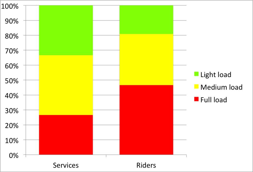
Assuming that each train carries all passengers from each station (not necessarily a valid assumption), the average customer waits 2:32. This doesn’t seem like a long time, but it means that while the trains are run on approximate four minute headways, the actual experience is that of five minutes, a loss of 20% of the quality of service. Five minute headways aren’t bad. The issue is that there are several periods where customers wait far longer than five minutes, resulting in overcrowding on certain trains, and longer waits for the same ones. The chart below shows wait times for each minute between 7:23 and 9:23. Green is a wait of 2:15 or less, yellow 4:30 or less (the advertised headway). Orange is up to 6:45, and red is longer. About one sixth of the time a train is running outside of the given headways. And three times, it is longer than 150% of the advertised headway.

Another personal observation is that, try as I might, I seem to always get caught on a packed-full train. This is due to the same phenomenon. Of the 30 trains noted, only eight of them had headways of more than 4:30. Those 8 trains—which, assuming a constant flow of riders, accounted for 27% of the passengers—served 56 of the 120 observed minutes, carrying 47% of the ridership! Ten trains came within 2:30 of the previous trains. These trains accounted for 33% of the service, but only served 19% of the ridership. So while one-in-three trains is underloaded, you only have a one-in-five chance of getting on one of those trains. And while only about a quarter of services are packed full, you have a nearly 50% chance of riding one of those trains. So if you wonder why it always seems like your train is packed full, it’s because it is. But there are just enough empty services that once a week you might find yourself in the bliss of a (relatively) empty train car.

Overall, I mean this as an observation of headways, not as an indictment of the MBTA. Running a railroad with uneven loads (especially at bus- and commuter rail-transfer stations), passengers holding doors and the like can quickly cascade in to a situation where certain trains are overloaded, and others pass by with plenty of room. Still, it’s infuriating to wait. But it’s interesting to have data, and to visualize what it looks like during the course of what seems to be a normal rush hour.

(On the other hand, there are some services, like the 70 bus, which have scheduled uneven headways and where the actual level of service is significantly impacted, but that’s the subject of another post entirely.)

Boston’s Worst Traffic Day of the Year

It’s tomorrow. The Friday before Columbus Day.

I have no actual data to back this up. Only anecdotal and empirical data. (Oh, and data from the Pike, which claims it’s second to the Friday before mother’s day in May, but I think that might be just for the Pike without the added benefit of every road north and south of the state, too. How prescient that this article comes out right after I post this.) But here’s what happens, and here’s how to avoid it.

Boston sees a lot of bad traffic. In the winter, when everyone is in town and weather hits, the entire system can grind to a halt. (The worst I know of was in December 2007 when a storm hit Boston around noontime. Snow fell heavily from the onset with temperatures in the mid-20s, so roads iced over. So many people left work early to beat the weather home that the roads filled up completely and plows couldn’t keep them clean. So the entire network ground to a halt until snow let up late in the evening.) But you can’t really plan for that. In the summer, Boston sees epic traffic jams headed out of the city to and from vacation spots, especially getting on and off of Cape Cod (the eight hour, 25-mile backup this July 4 this year was particularly bad), although other bottlenecks in New Hampshire and Western Mass can be painstakingly slow.

But the Friday before Columbus Day Weekend is the worst. Here’s why:

  • It’s the Friday before a long weekend. So in addition to Friday traffic, you have the masses headed on vacation, too.
  • But it’s a normal Friday. Of all the three-day weekends in the calendar, it’s the only one that almost no one extends. So there aren’t many people who get away a day early to ease the traffic.
  • It’s the last nice weekend of the year, for foliage and, often for weather. It’s still a pleasant time to go to Cape Cod, or the Berkshires, or Northern New England before the leaves fall and the temperatures plummet.
  • Not many people stay in town for the weekend. On Patriots Day (Marathon), July 4 (Fireworks), Labor Day, MLK Day and Memorial Day there are parades and ceremonies and the like that people attend locally. No one is celebrating Columbus anymore.
  • Oh, yeah: everyone from New York, Connecticut and Rhode Island wants to get to Vermont, New Hampshire and Maine. So guess where they all go? Massachusetts.
Personally, I’ve sat for two hours to go 10 miles on 128 on this wonderful day. I’ve also had a four hour drive from Springfield to Boston on the Turnpike. And my uncle had a three-hour trip from Providence to Boston, which culminated with him blindly following directions off of the Southeast Expressway on to Mass Ave when informed the Expressway wasn’t moving.
These weren’t due to accidents, but to volume. The system operates at-or-near capacity on a normal day. Add the factors above, and it is pushed way over capacity. Once that happens, everything stops.
But there are some suggestions. First of all, go where you are going later. We have wonderful apps and data and the ability to look at a computer screen and find out how long a trip is going to take. Take a look at Google Maps, or at MassDOT’s traffic map or data stream, and wait it out. As long as you plan to wait it out, you can sit by the river or go for a run and wait until the coast is clear (which should happen by 7 or 8 p.m.). Second, consider back roads, especially further from the city. Much of the congestion comes tourist-types descending on to main highways. People who don’t normally drive the roads don’t know about parallel options, and people who are unprepared for their onslaught get caught up in the hubbub. So if the Pike is a royal mess, try Route 9. If 93 is a parking lot, come through the city. 
The saying goes “if you can’t beat ’em, join ’em.” But that’s stupid. If you can’t beat ’em, either wait patiently, or find a route where they aren’t. Because if you don’t, you too will get to enjoy the Worst Traffic Day of the Year!

Mass State Police need to learn about bicyclists

Dateline: July 30, 2012. Cambridge.

I bicycle across the Harvard (Mass Ave) Bridge towards MIT (westbound). I signal in to the traffic lane to overtake a slower cyclist and to avoid a particularly rough stretch of pavement. Upon stopping for a light at Memorial Drive, the State Trooper tasked with directing traffic walked over.

“You’re not supposed to do that,” he said.

“Do what?”

“You can’t leave the bike lane to pass other vehicles.”

“Officer, I am allowed to leave the bike lane if conditions warrant, and this includes when pavement conditions are dangerous, or to overtake another vehicle.”

“No, you must stay in the bike lane. You can only leave the bike lane where it is dashed, at intersections like this,” he said, pointing to where the bike lane crosses Memorial Drive.”

At this point, he asked me if I would like to discuss this further. I was glad to. So he proceeded to write me a citation.

Here is what I was cited for:

85.11B: Pass No Pass Zone
85.11B: Fail to Stay Within Marked Lanes

I asked the officer to explain the citations. He refused. (This may be a violation of MGL 90C.2 which states that “[a] Said police officer shall inform the violator of the violation and shall give a copy of the citation to the violator.”) I asked him to please give me his name. He refused, and pulled his reflective vest over his name badge. He then took out his handcuffs and called for backup, asking me if I was being disorderly. Not wanting to further escalate the situation (and, sadly, not having a witness there to video the situation) I asked if I was under arrest and, upon being told that I was not, left.

And filed a complaint with the State Police.

I don’t want to dwell on the intimidation by the State Police; that will be dealt with internally. However, I would like to deal with the fact that the Mass State Police apparently do not understand bicycle law. (According to the ticket code and internet, the officer works at SC5, which is the Sturbridge Barracks. So, a) he’s probably not going to show up in court in Middlesex and b) he probably doesn’t cite a lot of cyclists.) First of all, bicyclists do not have to stay within bike lanes.

First, passing in a no passing zone. This would appear to fall under MGL 89.2. Here is the pertinent text from the law:

If it is not possible to overtake a bicycle or other vehicle at a safe distance in the same lane, the overtaking vehicle shall use all or part of an adjacent lane if it is safe to do so or wait for a safe opportunity to overtake.

It is, therefore, legal to change lanes to pass in the same direction. Additionally, the Massachusetts driver manual states that it is legal to cross solid white lines in a vehicle (see this PDF, page 10). In other words, a white line does not constitute a no passing zone. And none of this is mentioned in the cited section, 85.11B

Second, failure to stay within marked lanes. This falls under MGL 89.4A and 89.4B. It states, amongst other things, that:

Upon all ways the driver of a vehicle shall drive in the lane nearest the right side of the way when such lane is available for travel, except when overtaking another vehicle or when preparing for a left turn.

Since I was overtaking another vehicle, I was subject to this exception (there is a separate exception in 85.11B for dangerous situations, and the poor pavement in the bike lane on the Harvard Bridge would obviously fit within this exception). Additionally, while I did signal my turn, I am not required to do so if I need to keep both hands on the handlebars. The officer said that my left hand was extended to “wave off traffic” which is an interesting interpretation of the law from someone whose job is to enforce it.

Had the officer wanted to charge me with these offenses, he probably should have referenced them based on the actual statute. 85.11B simply refers to these statutes.

But, of course, I wasn’t in violation of either.

I expect this case to be dismissed without a hearing; it is likely that whatever magistrate vets the citation will not deem it worth the court’s time. If, however, a hearing date is set, I will make sure that it is well publicized. You’re all invited.

Update 10/21: I asked a State Trooper today on detail at the Head of the Charles if it was legal to leave a bike lane to pass another cyclist. He said it was perfectly legal.

Update 11/19: A court date has yet to be filed. Apparently it should be within 30 days. If it’s much longer, I could probably move to dismiss based on the delay.

Update 2017: I received a court date and asked for the charges to be dismissed. The officer had written that “I had created a situation where there were many cars honking at me.” I asked the Trooper there (not the same one) to look at the pictures and I showed where he was standing and where I was cycling and asked “do you think it is reasonable to assume that, in a busy intersection in Boston, it would be possible to ascertain which of several dozen vehicles was honking?” The case was decided in my favor.

I never did hear from the State Police regarding my complaint.

The next step on the BU Bridge area for bikes

The City of Boston recently made somewhat dramatic improvements to the bicycle facilities along Commonwealth Avenue. The formerly orphaned bike lane has been restriped through the intersection, and the new paint is all bright green. In addition, there are reflectors in the road to the right of the lane which I can attest are very visible from a vehicle at night. It’s a good start.

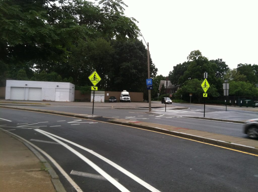
Meanwhile, Brookline has installed contraflow bike lanes on Essex Street to allow cyclists to go from Essex to Ivy to Carlton and allow a low-traffic alternative to get from the BU Bridge to the Longwood area. (And for those of us headed to Coolidge Corner, another block before we take a right.) Going towards the bridge, the town has striped in a bike lane. And, more importantly, they’ve cut a “bicycle crosswalk” across the BU Bridge loop (Mountfort Street) to allow cyclists to get from the Brookline streets to the BU Bridge without having to cross medians, loop around through the intersection of death, or ride the sidewalk to the light. It also allows cyclists coming from Brookline to skip Commonwealth altogether, a great boon to cyclists who don’t want to ride one of Boston’s widest and busiest streets. So, what was once a death trap for cyclists—and is still rather cumbersome—is getting better. (The picture at right shows the bike lane in the foreground and the crossover in the background.) There is some background information in this document.

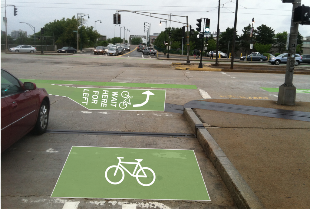
The next step, I think, is to better allow cyclists coming from the west on Commonwealth and headed towards Cambridge, would be a two-stage bike turn box. This is not a new concept—it even exists in Boston—and goes as follows:

  1. An eastbound cyclist on Commonwealth approaches the BU Bridge.
  2. The cyclists, upon a green light, goes through the light, then pulls in to a separate line to the right of the bike lane and turns their bike towards the bridge.
  3. Once the light changes, the cyclist pedals straight across and in to the bike lane on the bridge.
Here’s a picture of the current facility, with an idea of a two-stage bike box sketched in, as well as a bike box for cyclists coming from Mountfort:
I would hope this is on Boston Bikes’s radar screen (if it’s under their jurisdiction and not the state). It would be a great help to more novice cyclists who may not know it’s an option. The rest of us already do it.

The wrong way and wrong time to do a bike count

At some point, I might get off my high horse regarding bicycle counts on the Longfellow Bridge. But for now, I’m staying on. Why? Because I did my bike count on a Wednesday morning in June, to get a “typical” commute count (although, to be fair, with colleges out for summer it may have been a bit less traffic than some of the year). And I think I’m collecting better data than the established counts. Going through this process, I’ve found out more information about the National Bicycle and Pedestrian Documentation project, which is used as a basis for counting by local transportation agencies across the country, including the CTPS locally.


And I have not been particularly pleased with what I’ve found.


I think I originally buried the lede here, so I’ll add a bit here that I reiterate in the final paragraph: the bicycle and pedestrian count methodology treats bicyclists and pedestrians more as leisure users rather than treating them as using viable modes of transportation. We don’t take typical auto counts during vacation periods, and we shouldn’t do this for bicyclists, either. We should count bicyclists and pedestrians during normal use times, and design facilities based on this usage, especially in urban areas where bicycling and walking are important not only as transportation modes but as congestion mitigation resources

So what’s wrong with the national bike counting standards? First of all, the survey methods seem to come from about 15 years ago. From the directions:

Each counter should bring counting sheets, two writing utensils, a watch or cell phone for keeping time, and a clipboard or other device to write on. Counts are conducted in 15-minute intervals, and comprise the total volume of pedestrians and bicyclists traveling in both directions passing a given point. 

Here we are, in 2013, when everyone has an iPad and an iPhone and a laptop, and we’re taking counts with paper and pencil, and then admonishing people to make sure they don’t lose the paper because it is irreplaceable until it has been entered in to the database. Great. When I went to do my count, I didn’t even consider using paper and pencil, because it just didn’t make sense. I thought about writing a python script, but settled on Excel because it was easier to write and easier to test. But for a national program, how hard would it be to have an iPad app? Nothing fancy, just something where you tap a button every time you see a pedestrian or cyclist (it would be easy to have these buttons be customizable) and then directly upload the time-stamped data. 


Is there an up-front cost? Yes. Although my only overhead was the power to charge my computer’s battery and about 30 minutes on Google to figure out how to set up the Excel spreadsheet.


Second, why on earth would you survey typical use on July 4 weekend? I can not get over this. Their explanation is that it is selected because “The 4th of July period … will afford both a typical summer weekday and what is typically the busiest holiday period and activity period for recreational facilities and activities.” Three points. First, July 4 is not a typical holiday. You are likely to wind up counting a lot of people walking or bicycling to parades and fireworks. Are there a lot of parades on Columbus Day? So with one of the four annual counts, you’re collecting data which is unusable every other day of the year. Second, and excuse the italics, but in what universe is July 5, the Friday after July 4, is going to be a typical weekday? Half of my office is taking it off. Half of the country has vacation bounce messages on their emails this week. Third, while it is a busy time, so many people are traveling that it is not representative of many other weekends. I would contend that you’d get much more useful data by surveying a typical weekend in July rather than focusing on July 4. We’re spending all of this time and money to sample bicycle use, and we’re collecting just bad data.


Third, while uniformity is sometimes good, bicycle and pedestrian use is highly localized, so what works in one city may not work in another. In other words, there’s not a very good argument for standardizing bicycle count dates across the country other than to increase awareness. Awareness is a good thing. But it shouldn’t trump good data.


Harrumph.


You’d think that the NBPDP would at least be consistent in their data collection documentation, but this is not the case at all. This current survey is planned for a Thursday, Friday and Saturday. Their instructions document (available here) states that “Weekday counts should always be done Tuesday through Thursday, and never on a holiday.” Now, I understand that this is in relation to the national count in September, but, uh, guys? July 4-6 is a Holiday, Friday and Saturday. You’re 1-for-3. That might work in baseball, but it’s not a passing grade elsewhere.


Finally, in Boston this is an especially fraught issue. Why? Because on July 4, many of the city’s highest-use bicycle facilities are being closed. The Esplanade will be closed to bicyclists all day. The Longfellow and Harvard bridges are closing at 4 p.m. So any bicyclists after that point wishing to travel from Cambridge to Boston will have to either cycle across the Charles River Dam, or go up to the BU Bridge. Does it make any sense to take bicycle counts on this day? 


I’m not saying that my methodology was perfect, but it’s hard to comprehend how the current counts make much sense. If we go around collecting shoddy data and wind up undercounting bicyclists, we have only ourselves to blame when we get underdesigned facilities. It seems like high time to assess both the overall efficacy of the NBPDP, and especially whether Boston should participate in the program.


And a larger, and perhaps more important point: by prioritizing non-commuting periods, we are treating bicyclists as recreational users, not as a viable mode of transportation. Would we count cars during July 4 week? Of course not. AASHTO even says that such periods are “atypical” and would not have valid data. By counting traffic at these times, we are doing a severe disservice to bicycle advocacy.

Longfellow Bike Count

One of the issues I’ve touched on in the Longfellow Bridge series is the fact that there as no bicycle count done at peak use times—inbound in the morning. The state’s report from 2011 (PDF) counted bicyclists in the evening, and shows only about 100 cyclists crossing the bridge in two hours. Anecdotally, I know it’s way more than that. At peak times, when 10 to 20 cyclists jam up the bike lane at each light cycle, it means that 250 to 500 or more cyclists are crossing the bridge each hour. So these numbers, and bridge plans based on them, make me angry.

But instead of getting mad, I got even. I did my own guerrilla traffic count. On Wednesday morning, when it was about 60 degrees and sunny, I went out with a computer, six hours of battery life and an Excel spreadsheet and started entering data. For every vehicle or person—bike, train, pedestrian and car—I typed a key, created a timestamp, and got 2250 data points from 7:20 to 9:20 a.m. Why 7:20 to 9:20? Because I got there at 7:20 and wanted two hours of data. Pay me to do this and you’ll get less arbitrary times.

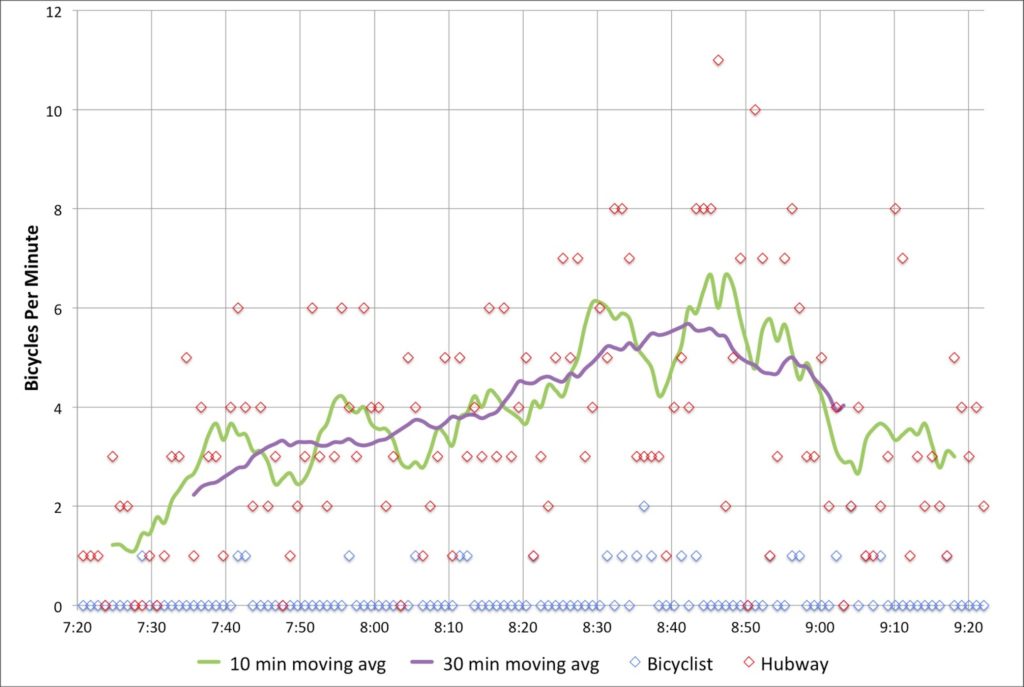
But I think it’s good data! First of all, the bikes. In two hours of counting, I counted 463 bicyclists crossing the Longfellow Bridge. That’s right, counting just inbound bicyclists, I saw more cyclists cross the Longfellow in one direction than any MassDOT survey saw in both directions. The peak single hour for cyclists was from 8:12 to 9:12, during which time 267 cyclists crossed the bridge—an average of one every 13.4 seconds. So, yes, cyclists have been undercounted in official counts.

Are we Market Street in San Francisco? Not yet. Of course, Market Street—also with transit in the center—is closed to cars. [Edit: Market Street is partially closed to private vehicles, with plans being discussed for further closures.] And at the bottom of a hill, it’s a catchment zone for pretty much everyone coming out of the heights. They measured 1000 bikes in an hour (with a digital sensor, wow!), but that was on Bike to Work Day; recent data show somewhat fewer cyclists (but still a lot).

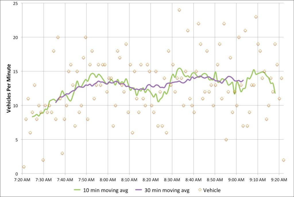
I also counted vehicles (1555 over two hours; 700 to 800 per hour, including three State Troopers and one VW with ribbons attached that passed by twice), inbound pedestrians (about 100, evenly split between joggers and walkers, although there were more joggers early on; I guess people had to get home, shower and go to work) and even inbound Red Line trains (30, with an average headway of 4:10 and a standard deviation of 1:50). I didn’t count outbound pedestrians, or the exact number of people I saw stopping to take pictures (at least three on my little nook of the bridge).

But did you come here for boring paragraphs? No, you came for charts! Yay charts! (Also, yay blogging at 11:20 p.m. when I should be fast asleep. Click to enlarge.)

First, bikes. Cyclists crossing the bridge started out somewhat slow—the moving average for the first 20 minutes was only one or two per minute. But the number of cyclists peaks around 8:40—people going in to the city for a 9:00 start—before tapering off after 9. I’ve written before about seeing up to 18 people in line at Charles Circle which is backed up by these data; the highest single minute saw 11 cyclists, and there were four consecutive minutes during which 36 bikes passed. At nearly 6 bikes per minute for the highest half hour, it equates to nearly 360 bikes per hour—or 10 per 100 second light cycle. Too bad we’re all squeezed in to that one little lane. (Oh, here’s a proposal to fix that.) If anything, these numbers might be low—the roads were still damp from the overnight rain early this morning.

What was interesting is how few Hubway bikes made it across the bridge—only 25, or about 6% of the total. With stations in Cambridge and Somerville, it seems like there is a large untapped market for Hubway commuters to come across the bridge. There are certainly enough bikes in Kendall for a small army to take in to town.

Next, cars. The official Longfellow traffic counts show about 700 cars per hour, which is right about what my data show. What’s interesting is that there are two peaks. One is right around 8:00, and a second is between 8:30 and 9:00. I wonder if this would smooth out over time, or if there is a pronounced difference in the vehicular use of the bridge during these times. In any case, 700 vehicles per minute is not enough that it would fill two lanes even to the top of the bridge, so the second lane—at this time of day, anyway—is not necessary on the Cambridge side.
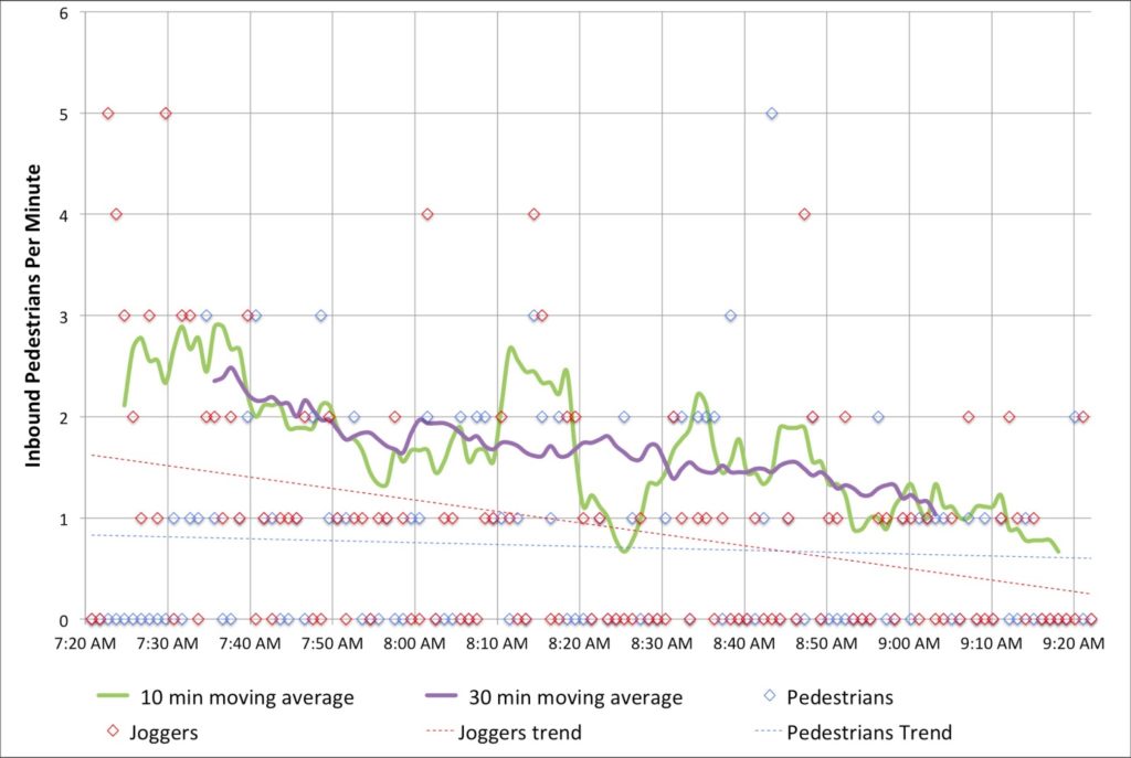
I also tracked foot traffic. I did my best to discern joggers and runners from commuters. Joggers started out strong early, but dwindled in number, while commuters—in ties and with backpacks and briefcases—came by about once every minute. I was only counting inbound pedestrians, and there were assuredly more going out to Kendall. Additionally, I was on the subpar, very-narrow sidewalked side; the downstream sidewalk is twice the width (although both will be widened as part of the bridge reconstruction).
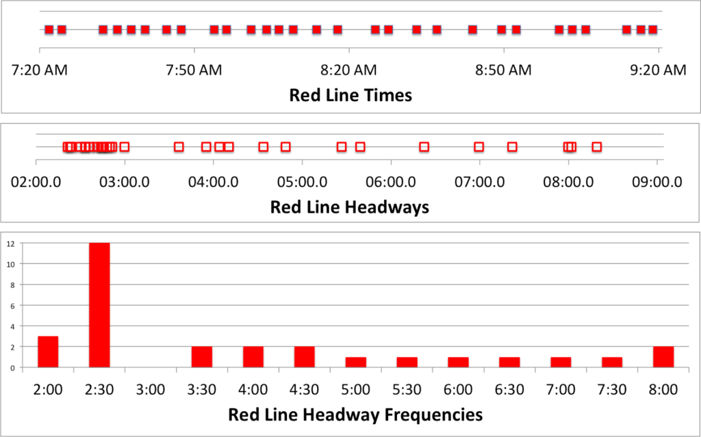
And I counted when the trains came by. In the time that 2500 bikes, pedestrians and cars crossed the bridge, 30 trains also did. Of course, these were each carrying 500 to 1200 people, so they probably accounted for 25,000 people across the bridge, ten times what the rest of the bridge carried. Efficiency! The train times are interesting. The average headway is 4:10, with a standard deviation of 1:58. However, about half of the headways are clustered between 2 and 3 minutes. That’s good! The problem is that the rest are spread out, anywhere from 3:30 to 8:30! Sixteen trains came between 7:20 and 8:20, but only 14 during the busier 8:20 to 9:20 timeframe. I wonder if this is due to crowding, or just due to poor dispatch—or a combination of both.

In any case, what Red Line commuter hasn’t inexplicably sat on a stationary train climbing the Longfellow out of Kendall? Well, after watching for two hours, I have an answer for why this happens!  It is—uh—I was lying. I have no idea. But I say no fewer than a half dozen trains sit at that signal—and not only when there was a train just ahead—for a few seconds or even a couple infuriating minutes. I was glad I wasn’t aboard.

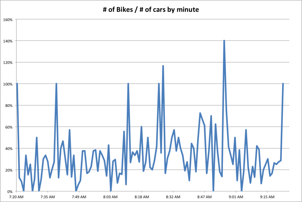
Finally, we can compare the number of bikes as a percentage of the number of cars crossing the bridge each minute. Overall, there were 30% as many bikes as cars. But seven minutes out of the two hours, there were more bikes across the bridge than vehicles. Cars—due to the traffic lights—tend to come in waves, so there’s more volatility. Although bikes travel in packs, too. Anyway, this doesn’t tell us much, it’s just a bunch of lines. But it’s fun.

Is a part-time bike lane appropriate for the Longfellow?

So far in our irregular series on the Longfellow Bridge we’ve looked at the difficulty accessing the bridge from the south, the usage of the bridge compared to the real estate for each use and how many bikes are actually using the bridge at morning rush. While my next step is to actually go out and count bikes (maybe this Thursday!), I’ve been thinking about what sort of better inbound bicycle infrastructure could be implemented for the bridge.

Here’s a graphic. I’ll make more sense of it below (Click to enlarge):

Here are the issues at hand:

  • Peak bicycling occurs between 7:30 and 9:00 a.m., when bicyclists traveling from Cambridge, Somerville, Arlington and beyond converge on the Longfellow to commute to work in downtown Boston. For nearly any destination in Back Bay and Downtown, it is by far the easiest access.
  • There is much less cycling outbound at rush hour because of mazes of one-way streets combined with heavy vehicular traffic on the other access roads (i.e. Cambridge Street).
  • Thus, the highest bicycle use at any time on the bridge is during the morning rush hour inbound, but while plans indicate a wide, buffered bike lane going outbound, the inbound lane will barely be widened.
  • Since the bridge has a noticeable incline from the Cambridge side, there is a wide spread of cyclist speeds, and it is reasonable to expect cyclists to want to overtake during heavier use times.
  • With improvements to Beacon Street in Somerville as well as the access through Kendall Square, even more cyclists will crowd the bridge in the morning.
  • With the expansion of Kendall Square and its reliance—to a degree—on bus shuttles, it can not be allowed to gridlock over the bridge during peak periods (generally evening rush hour).
In other words, bikes need more room in the morning. And cars need more room in the evening (a single lane on the Longfellow would only accommodate somewhere along the lines of 50 vehicles, and might quickly queue in to Kendall). Luckily, these needs are not necessarily mutually exclusive, and a part-time bike lane would be a possible solution to give bikes the room they need at peak times, while not piling traffic in to Kendall at other times.
In general, part-time bike lanes have been created when parking is allowed at some times and not others (here’s an example from the Embarcadero in San Francisco). The Longfellow is unique in that it has dramatically different usage rates between motor vehicles and bicycles (there are probably twice as many bikes in the morning than the evening, and twice as many cars in the evening than the morning). Bridge real estate is obviously limited—in a perfect world there would be two lanes for traffic and a wide, buffered bike lane, and a pedestrian promenade. So it would be a engineering, logistical and educational challenge to implement such a program.
Here’s the thing: the bridge will be effectively shut down for three years. Traffic will be shifted around for long enough that drivers won’t well remember the previous infrastructure, so it would be a good time (perhaps the only time) to try something drastically new. Here’s a sketch of an idea:

Between Kendall Square and Memorial Drive, Main Street will merge from two lanes to one, to the left. The right lane will be for turns on to Memorial Drive only, and will be set off from straight-ahead traffic with bollards or a median.

Past the Memorial drive ramps:

The left inbound lane is kept at 11 feet and all non-Memorial traffic merges in to it before the bridge. The constriction for the Longfellow traffic is throughput at Charles Circle, so this shouldn’t dramatically affect traffic, especially since Memorial Drive traffic would exit in a dedicated lane. This will allow traffic to comfortably travel in it at all times. The lane would be signed as Vehicle Traffic, All Times. It would be separated from the right lane by an unusual marking such as a double broken white line. 

The right inbound lane should be narrowed to 9 feet in width. Height restrictions (chains hanging from an overhead support) could be hung at intervals to discourage trucks and buses but signage would likely suffice. It would be signed as Bikes Only Except Weekdays 3 PM to 7 PM. No Trucks or Buses. It would be marked with diamonds or some other similar feature as well as “Sharrows” and separated from the bike lane by two solid white lines with no painted buffer in between, potentially with infrequent breaks.  

The bike lane would be 6 feet wide and the two lines would serve as a 2 foot buffer at evening peak. It would be signed as a regular bike lane.

This will extend to the top of the bridge where the grade evens. Beyond that point, there is less need for a “climbing lane” for cyclists, and the bike lane will taper to one, buffered lane. The left lane stay 11 feet, and the right lane 9, but it will be open to cars at all times, with a continued buffered bike lane. Having the right lane closed to trucks and buses will dramatically increase the comfort level for bicyclists who are often squeezed by large vehicles, who will have no business in the right lane.

At the Cambridge End of the bridge, the merge to one lane before the Memorial Drive will funnel all Cambridge-origin traffic in to the left lane (this is the only origin for trucks and buses which can not fit under the Memorial Drive bridges). During non-peak afternoon hours, the Memorial Drive intersection would then join this traffic in a short merge lane after crossing the bicycle facility. At peak hours, it would continue in the right lane. This means that for a truck or bus to use the right lane, it would have to actively change lanes, meaning that even during rush hour, bicyclists would not be pinched by frequent tall tour buses and delivery vehicles. And at other times, most of the origin traffic from Cambridge would already be in the left lane, and only the Memorial Drive traffic—which already stops at a stop sign—would have to be signed in to the lane based on the time of day. The irregular lane markings will clue most drivers in to the fact that there is something different about the bridge, as will signage placed on the bridge approaches.

At the Boston end of the bridge, just before “salt/pepper shaker” the bridge could be widened (for instance, see this older image) to allow bicyclists to stay in a buffered bike lane and cars to sort in to three full (if narrow) lanes. However, two lanes might be preferable to allow trucks and buses to get from the left lane on to Charles Street (or such vehicles could be forbidden from this maneuver and forced straight on to Cambridge or left on to Embankment Road). In this case, enough room for side-by-side cycling in a bike lane—at least 7 or 8 feet—should be allowed (this is not showin the above schematic).

The potential for a flyover bike ramp to the unused portion of Embankment Road should not be discounted, either, as it would siphon much of the bicycle traffic away from the congested Charles Circle area. I called this the “Gateway Overpass” as a lower, gentler and wider bridge could span from the Embankment Road area across Storrow Drive to the Esplanade and allow easy egress to Charles Street across the Storrow offramp. The current bridge is narrow, steep and congested, and provides far more clearance over Storrow Drive than necessary. A new bridge is proposed (see page 10 of this PDF) but I think a level bicycle facility would be very helpful to help bikes avoid the congestion at Charles Circle.

If this project were found to be either dangerous for cyclists or a major impediment to traffic in Cambridge, it could be changed simply by restriping existing lanes, so there would be no major cost involved. If it constricted traffic enough, the lanes could be restriped with a buffer to allow a wider cycling facility inbound at all times.

I think it’s worth study, if not a try.

Longfellow Bike Traffic update

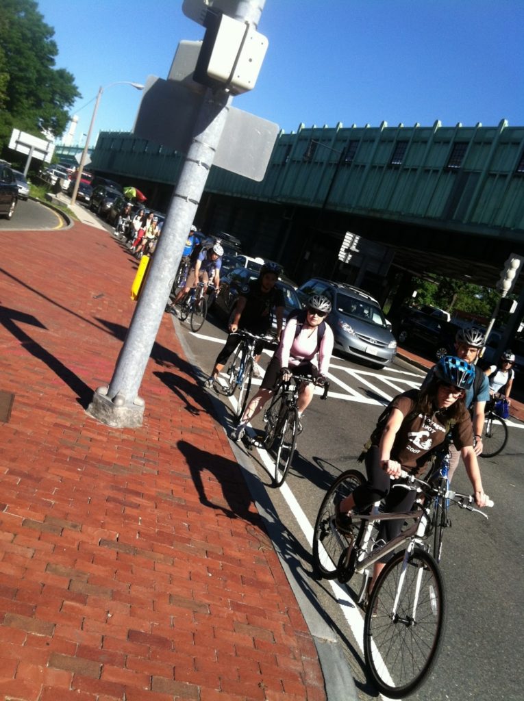
I came in this morning across the Longfellow. As I jockeyed for position through Kendall, I knew it was going to be busy on the bridge. I’ve seen ten bicycles per light cycle on the bridge, but today the lane was chock-a-block with bikes all the way across the bridge. With minimal auto traffic, faster cyclists were swinging in to the right lane and passing slower cyclists. And when we got to the bottom, well, it was quite a sight.

I quickly hopped the sidewalk to take a picture. By my quick count, there were 18 cyclists in line waiting for the light to change at the bottom of the bridge. Last month, I’d assumed 10 bicyclists per light cycle, which would equate to 360 per hour. At 18 bicyclists, this is an astounding 648 bicycles per hour, or one every six seconds. That’s nearly as many vehicles as use the entire bridge in the AM peak (707). And this is despite the fact that the Longfellow is a narrow and bumpy bicycle facility.

So it is a shame that the current plan for the bridge allocates just as much space to vehicles, and does not appreciably expand the inbound bicycle facility. As we crossed today there were few vehicles, but bicycles could barely fit in the lane. Since the bridge hasn’t been rebuilt yet, there is still time to advocate for fewer vehicle lanes (one lane expanding to two would be mostly adequate) and a much wider bike lane allowing for passing and a buffer.

The current bicycle counts are only for the evening commute where, as I’ve pointed out before, it’s much harder to get to the Longfellow due to traffic, topography and one-way streets. I think it’s high time for a peak morning bike count on the Longfellow. And time to suggest to MassDOT they reexamine the user base for the roadway before it gets reconstructed and restriped.

Plus, if we have 650 bikes per hour using the current, subpar facility, imagine the bike traffic once the lane is wider and well-paved. To infinity and beyond! Or, at least, to 1000.