Service, Not Storage

One of the many issues with the Allston project that I have been way too involved with is that the State maintains that they need a midday layover yard for Commuter Rail equipment. Why? Because they plan to add capacity to South Station and, since they can’t stack out-of-service trains in the terminal, need somewhere to store them when they’re not in use in the middle of the day. (Off-topic but relevant: the need for and cost of which could be obviated completely simply by building the North-South Rail Link; thru-running is so much more efficient that in Philadelphia SEPTA runs 44 trains per hour through its four track tunnel at rush hour while the MBTA peaks at 32 trains combined on 22 tracks at North and South stations.)

The relevant issue, however, is how silly it is to build large rail yards on prime real estate in order to not run service!

The supposed “need” for this whole facility could be obviated simply by running more trains in service in the midday. (Some layover space could be built between Cambridge and Everett streets in Allston without impacting transit operations and development of the Beacon Park Yards.) If you have more trains in service, you don’t need storage for them. Considering that 75% of the costs of running Commuter Rail in Massachusetts are fixed, much of the marginal cost of providing increased service would be made up for by the opportunity cost of not building such an unnecessary facility. Most every other major Commuter Rail line runs more frequent midday service than the MBTA, even on lines to major anchor cities like Worcester, Providence and Brockton. In English: you have the trains, and the track, and the stations. Just run more darned trains already!

With that said, you still need to figure out where to run these darned trains. Obviously, increasing service on current lines to large cities and “Gateway Cities” makes sense. But there’s actually a way to increase service to Western Massachusetts without any major investment in track, stations or additional equipment. Right now, several train sets begin and end their day in Worcester. These trains could, instead, begin their trips further west, providing service to Springfield the Pioneer Valley.

The Commonwealth and Feds recently spent $83 million to upgrade the Connecticut River Line for passenger service, and the Boston and Albany main line already hosts Amtrak trains (albeit at a pitiful top speed of 59 mph). So you might as well get some use out of it! There is a vague plan to provide commuter service in the Pioneer Valley soon linking Greenfield, Northampton, Holyoke and Springfield, and connecting with upgraded Springfield-Hartford-New Haven “Knowledge Corridor” service. Service couldn’t start overnight, steps would include working out a track use agreement with CSX and qualifying crews west of Worcester. But the track (with the exception of layover facilities in Greenfield; I assume trains could be stored overnight on tracks in Springfield’s station), stations (with the exception of Palmer where you might want to build a new station) and trains are in place. It’s not a big leap to running service.

Here’s what a schedule would look like for the trips serving Boston, Springfield and Greenfield. Train numbers are shown for current Amtrak or MBTA Commuter Rail service, and use current travel times, although the Boston and Albany ran two-hour Springfield-to-Boston schedules in 1950 with stops in Palmer, Worcester, Framingham and Newtonville. (Amtrak 448/449 is the Lake Shore Limited to and from Chicago via Albany, 55/56 is the Vermonter from Saint Albans to Washington D.C.)

Eastbound
       Train # →          MBTA 508     MBTA 552       NEW       AMTK 56     AMTK 449  
Dep Greenfield 5:45 13:36
Dep Springfield 5:45 6:45 13:00 14:35 17:33
Arr Boston 8:20 9:07 15:20 20:01
Westbound
       Train # →            NEW       AMTK 448     AMTK 55     MBTA 521     MBTA 551  
Dep Boston 9:38 12:50 17:05 19:35
Arr Springfield 12:00 15:18 15:15 19:35 22:00
Arr Greenfield 16:15 23:00

Rightly or not, Western Mass often feels like it gets the short end of the bargain when it comes to transportation funding. There has been hundreds of millions of dollars spent on infrastructure (most notably the Knowledge Corridor and Springfield Union Station), yet very little service to show for it. This mistake would be compounded by overbuilding layover facilities in Boston and siloing operations in Eastern and Western Massachusetts. Any passenger movements would need to accommodate CSX freight traffic between Worcester and Springfield, and in the long term, much more increased service may require a larger investment to re-double track the B&A line to Springfield (and to increase line speed where possible as well).

In any case, rail service in Massachusetts has long been focused on Boston, with a minimal statewide transportation plan (well, beyond taking donations from Peter Pan, buying them buses and having them get stuck in traffic on the Pike). The state has taken hundreds of millions of Federal dollars (and local match) to upgrade the line in the Pioneer Valley, but it barely runs any service. It would be a politically wise move to better serve Western Mass and, given traffic and tolls, would probably attract significant ridership, too.

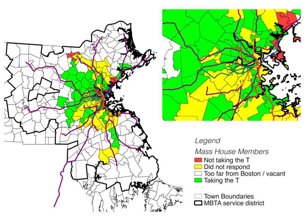
Mapping Gov on the T

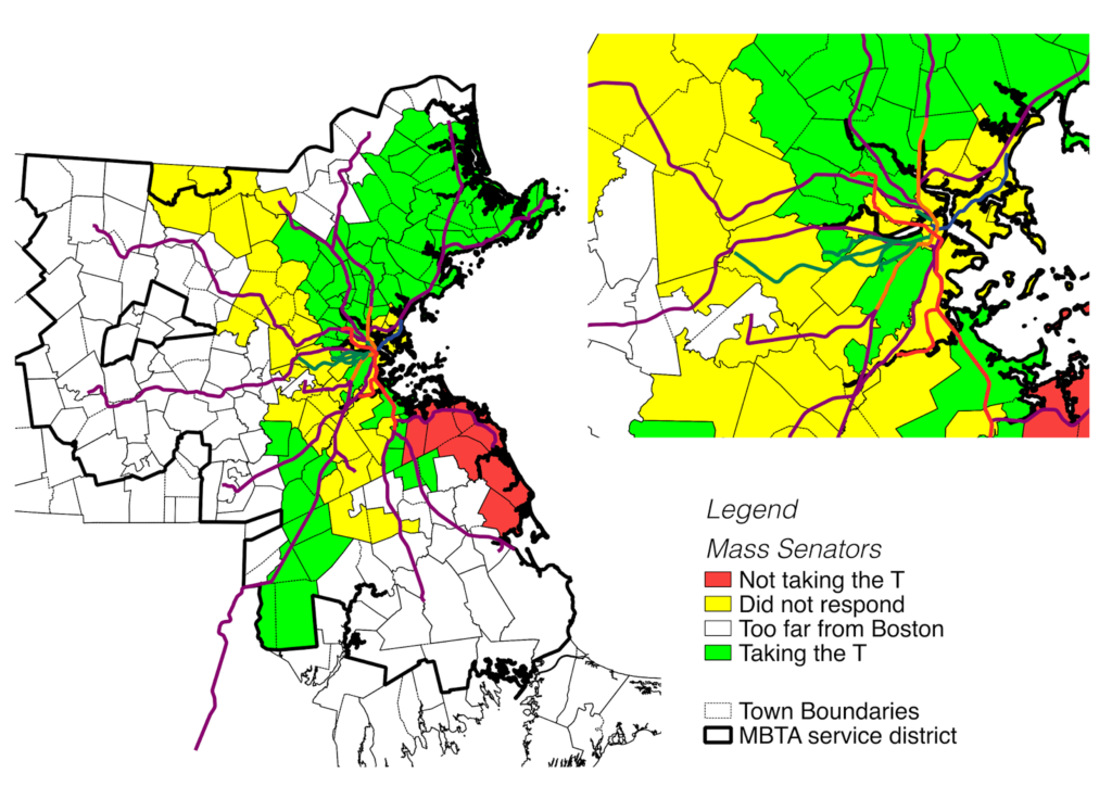
There’s a great grassroots group which is pushing for Massachusetts state legislators, who live within an hour (*) of the State House, to take the T to work on March 19, called Gov on the T. They have a list of members of the General Court, and have asked for commitments as to whether the will take the T to work. I decided that this begged to be mapped, so I did.

First, a couple of words (and the asterisk above). I have no idea how they calculated an hour, but it doesn’t make much sense, and there’s a fragmented area that is represented by the officials they’ve asked. For instance, the representative from Billerica is not listed, but lawmakers from Lowell are. The Senator from Gloucester is on the list, but not the representative. The representative from Bridgewater is on the list, but the one from Hingham is not. I think it would make much more sense to apply this test to any Senator or Representative who serves constituents in a town within the MBTA’s service district, which I’ve outlined on my maps.

(GovOnTheT, if you are reading, this, I am happy to select these districts and give you a list.)

Anyway, here is a map of House members who have pledged to take the T:

And here is a map of the Senate:

I think this is great, and partially because it is very grassroots: it’s not being pushed by a lobbying group, but by a couple of people who are pissed off that their legislators all drive because they have free parking on Beacon Hill. I hope that Gov on the T becomes a regular happening, and that legislators are held accountable. Those who don’t take the T—and vote accordingly—ought to get primary challenges, especially in districts where many of their constituents depend on transit. Take a look at some of the districts where representatives aren’t taking the T. There’s Lynn, Revere, Winthrop and the South Shore. And districts where the representatives are MIA, for instance: much of Cambridge’s Senate representation and house members in Newton, Brookline and most of Boston. Let’s hold our representation accountable.

Why does going to Amherst require a transfer?

This past weekend, I was trying to get from Hartford to Amherst. This should be a reasonably easy trip. Peter Pan Bus runs about a dozen trips daily between Hartford and Springfield and eight between Springfield and Amherst. I went looking for tickets, figuring that at least some of those trips would be through-runs. All required a transfer in Springfield. Which is odd, because to get from Boston to Amherst—except for Fridays and Sundays during the academic year—also requires a transfer.

It got me to thinking: can you get to Amherst by bus from anywhere further than Springfield without a transfer at the decrepit-if-soon-to-be-replaced Springfield bus station? It took some reverse engineering of the bus schedules (update: somewhat available in PDF here), but I am pretty sure the answer is a resounding “no.”

This is a problem. It is an issue both in the time it takes to get from Boston to Amherst with a transfer—generally more than three hours for a drive which would be a direct trip of 1:45—and the psychological effect that people do not like to have to transfer (especially if they have to sit in a post-apocalyptic bus station that hasn’t seen a broom since the mid-’70s). There is research about transfer penalties in transit, and it is likely that this carries over to intercity bus travel as well.

Amherst to Boston should be a strong bus market, even at times when undergraduate students aren’t decamping for home on the weekend. Amherst to New York City should also be a well-traveled route. In theory, one bus could start in Amherst and run to Springfield an on to Boston in 2:00, with a transfer available to Hartford and New York. In practice, there is minimal schedule coordination, and every passenger is required to get off of one bus, wait in the bus terminal, and get on to another. By imposing a penalty which doubles the travel time (to Boston) and requires a transfer at a substandard bus station, it discourages students to use the bus system, and indirectly encourages them to use a private automobile, despite $4 gas and tolls.

I ran some times for these routes on a weekday (I chose May 7). The average transfer time for a Boston-to-Amherst trip is 27 minutes. The average transfer for a New York/Hartford-to-Amherst trip is 40 minutes. Departing Amherst the transfer times are a bit better: 20 minutes to Boston and 28 to Hartford/New York. But it still incurs a significant time penalty, and a significant issue of not having through service.

There is a model for this sort of service: Concord Coach’s service from Boston and Logan airport to Portland Maine and beyond. Several times a day, two buses leave Boston and Logan and run to Portland. Since the market beyond Portland is smaller, only one bus is needed to go beyond Portland to Augusta and Bangor. The bus which originates in Boston runs through, and passengers coming from Logan and who wish to go beyond Boston get off one bus and on to the other. The transfers are timed for minimal delays, and the buses will wait for each other if one is running late.

Peter Pan’s service could mirror this from Amherst. Buses would leave Boston and run to Springfield, a major market. At the same time, buses from New York to Springfield would be coordinated to arrive a few minutes before the Boston bus. Those passengers would still transfer if they wanted to travel beyond Springfield—and a few minutes of schedule padding could be built in due to traffic conditions south of Hartford (with more frequent service to come on the New Haven-Hartford-Springfield rail corridor, train services could be synched with bus service as well). Boston passengers to Amherst would stay on the bus, and instead of a 10 to 30 minute transfer, it would necessitate a five minute stop.

This would mean that passengers from Boston to Amherst would see significantly shorter trips and would no longer have to move from one bus to another. If Peter Pan claims that there is not enough demand for the market, perhaps it is because their service is substandard on the route. For anyone who has taken a bus to Amherst it’s a joke that you have to change in Springfield. In reality, it is a detriment to service.

A major stakeholder in this should be the Commonwealth of Massachusetts. They operate, in Amherst, a major research and educational institution, which should have strong ties to Boston. There’s no direct highway access to UMass; driving between the two requires an indirect trip via Springfield and Northampton, or a narrow road from Palmer. The state also, through it’s BusPlus+ program, subsidizes Peter Pan routes, buying buses for the operator in exchange for Peter Pan’s operation of commuter routes. MassDOT should, as part of this relationship, encourage Peter Pan to run direct service between Amherst and the three largest cities in the state: Boston, Worcester and Springfield. Not doing so is a disservice not only to the traveling public, but also to the state’s major public university. It’s nonsensical that you can’t get on a bus in Amherst and get to Boston. That could—and should—change.

Massachusetts’ DMU plan could well provide better rail service

Last year (oh, wait, in 2012—gosh) I wrote about the sorry state of affairs of the MBTA’s commuter rail system. Outside of rush hour, trains travel infrequently and on seemingly random schedules. Even in closer-in, denser areas, service is provided only every couple of hours. (Oh, yeah, and service is slow, too.) There is probably demand for better service but little supply, and it’s partially a cost issue: running full, 1000-passenger commuter trains (with poor acceleration) is a losing proposition when few seats are filled.

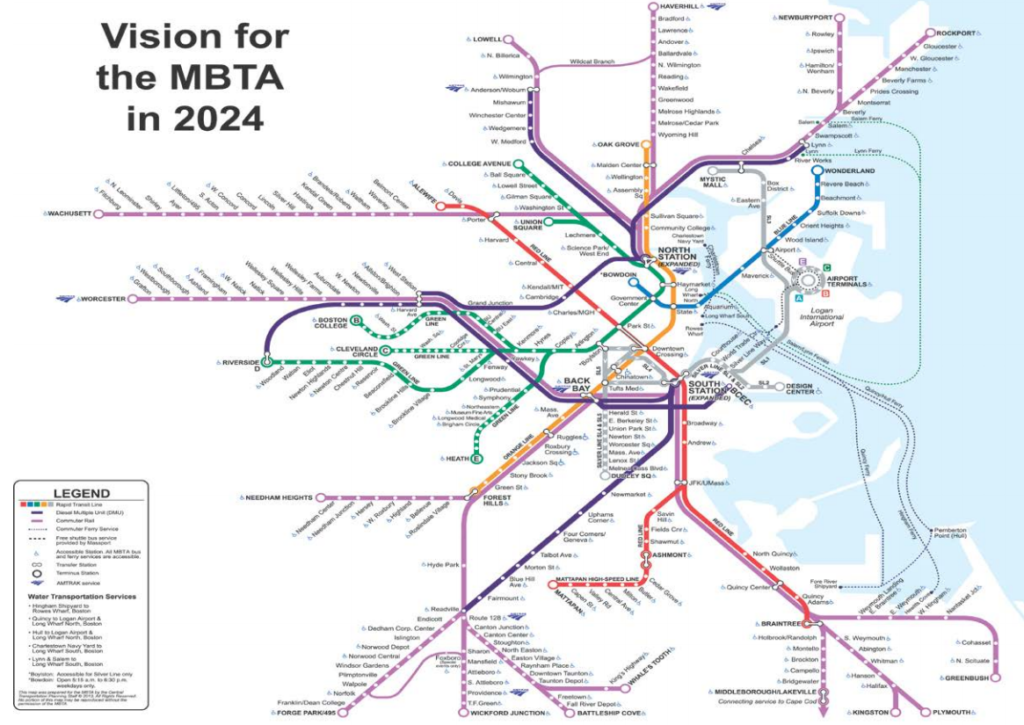
Enter the DMU. The diesel multiple unit, while sparsely used in the US, is a frequent sight abroad, providing service at times when a full trainset is not needed. They leverage the direct connections between town centers that exist along rail lines, allowing fast service to the city center without rolling empty cars through the midday and evening. The plan imagines several lines utilizing DMUs on rail segments inside 128—most of which do not have paralleling subway service:

 (The full report, which appears to have been scanned as a PDF, is here.)

If implemented, this would go a long way towards improving service on several underserved corridors. The Fairmount Line currently is served infreqently by full-length commuter trains, a complete mismatch of service. Lower capacity and better acceleration would provide a much better benefit there. The Worcester Line—which will soon have added service—provides very little service in Newton, the most densely-populated portion of the line (it is served by express buses, which crawl through traffic on the Turnpike). Better service to Lynn will provide some of what a far-costlier rapid transit connection would—faster and more frequent service to Boston, and service to Woburn will provide better connectivity north of Boston, as well as further reducing the run times for trains to Lowell, currently one of the faster trips in the system, and one which, if the state of New Hampshire pays, could be extended northwards to the granite state to provide an alternative for the traffic-choked I-93.

The most interesting piece here is the inclusion of the Grand Junction through Cambridge. This page would argue for a complete rebuild of this line, with grade separation and electrification, and its operation as a crosstown link between North Station, Cambridge and Allston, currently a serpentine trip by car, much less by transit. It also would provide better access to the fast-growing Cambridge area which is currently poorly-served by highways and at the whim of the over-capacity Red Line. Currently, commuting from west of Boston to Cambridge is a bit of a black hole; there is no good connection between the Worcester Line and Cambridge without going all the way to South Station and backtracking across the Red Line. The Grand Junction is an underutilized piece of infrastructure which could be put to very good use.

What really matters is how the MBTA decides to implement DMU service. (That is, if it can be funded and overcome local opposition; double-dipping Cambridge City Councilman and State Rep Tim Toomey helped to quash a plan to route some commuter service over the Grand Junction in 2010. Needless to say, he did not receive my vote in recent council elections). If it uses it as a cost-saving measure to run the same level of service with less equipment, it will simply maintain the status quo. For instance: there are only eight commuter rail trains from the stations in Newton to Boston daily. And the Fairmount Line has 60 minute headways with no evening or weekend service. Running the same level of service with different equipment would be a wasted opportunity (if a minor cost savings).

If the state provides faster and more frequent service to these lines, say, with 15 or 20 minute headways all day, it will come much closer to providing a transit level of service, and actually providing service to these communities. With new stations at Yawkey, near New Balance and the intermediate “West Station” the Worcester Line would provide better connections through an underserved portion of Boston and Newton (with frequent, timed shuttle service across the Grand Junction a dramatic bonus). And the Fairmount Line, which currently provides piss-poor service to one of the states most disadvantaged communities, could prove an economic lifeline, if only the trains ran more than hourly.

And if DMUs are successful, they could be implemented in other parts of the system. Why run a full trainset at off-peak hours from Newburyport to Boston when a transfer at Beverly would provide the same level of service? Perhaps instead of the hourly locomotive-hauled train from Boston to Lowell, half-hourly DMUs would double the service at a minimal additional cost. Perhaps DMUs could provide service further west of Worcester to Springfield and Amherst. Hopefully, the state sees DMUs as a tool, not as a cost-cutting measure. If they implement this service better than they photoshopped the map, they could dramatically improve travel in Massachusetts.

Mass State Police need to learn about bicyclists

Dateline: July 30, 2012. Cambridge.

I bicycle across the Harvard (Mass Ave) Bridge towards MIT (westbound). I signal in to the traffic lane to overtake a slower cyclist and to avoid a particularly rough stretch of pavement. Upon stopping for a light at Memorial Drive, the State Trooper tasked with directing traffic walked over.

“You’re not supposed to do that,” he said.

“Do what?”

“You can’t leave the bike lane to pass other vehicles.”

“Officer, I am allowed to leave the bike lane if conditions warrant, and this includes when pavement conditions are dangerous, or to overtake another vehicle.”

“No, you must stay in the bike lane. You can only leave the bike lane where it is dashed, at intersections like this,” he said, pointing to where the bike lane crosses Memorial Drive.”

At this point, he asked me if I would like to discuss this further. I was glad to. So he proceeded to write me a citation.

Here is what I was cited for:

85.11B: Pass No Pass Zone
85.11B: Fail to Stay Within Marked Lanes

I asked the officer to explain the citations. He refused. (This may be a violation of MGL 90C.2 which states that “[a] Said police officer shall inform the violator of the violation and shall give a copy of the citation to the violator.”) I asked him to please give me his name. He refused, and pulled his reflective vest over his name badge. He then took out his handcuffs and called for backup, asking me if I was being disorderly. Not wanting to further escalate the situation (and, sadly, not having a witness there to video the situation) I asked if I was under arrest and, upon being told that I was not, left.

And filed a complaint with the State Police.

I don’t want to dwell on the intimidation by the State Police; that will be dealt with internally. However, I would like to deal with the fact that the Mass State Police apparently do not understand bicycle law. (According to the ticket code and internet, the officer works at SC5, which is the Sturbridge Barracks. So, a) he’s probably not going to show up in court in Middlesex and b) he probably doesn’t cite a lot of cyclists.) First of all, bicyclists do not have to stay within bike lanes.

First, passing in a no passing zone. This would appear to fall under MGL 89.2. Here is the pertinent text from the law:

If it is not possible to overtake a bicycle or other vehicle at a safe distance in the same lane, the overtaking vehicle shall use all or part of an adjacent lane if it is safe to do so or wait for a safe opportunity to overtake.

It is, therefore, legal to change lanes to pass in the same direction. Additionally, the Massachusetts driver manual states that it is legal to cross solid white lines in a vehicle (see this PDF, page 10). In other words, a white line does not constitute a no passing zone. And none of this is mentioned in the cited section, 85.11B

Second, failure to stay within marked lanes. This falls under MGL 89.4A and 89.4B. It states, amongst other things, that:

Upon all ways the driver of a vehicle shall drive in the lane nearest the right side of the way when such lane is available for travel, except when overtaking another vehicle or when preparing for a left turn.

Since I was overtaking another vehicle, I was subject to this exception (there is a separate exception in 85.11B for dangerous situations, and the poor pavement in the bike lane on the Harvard Bridge would obviously fit within this exception). Additionally, while I did signal my turn, I am not required to do so if I need to keep both hands on the handlebars. The officer said that my left hand was extended to “wave off traffic” which is an interesting interpretation of the law from someone whose job is to enforce it.

Had the officer wanted to charge me with these offenses, he probably should have referenced them based on the actual statute. 85.11B simply refers to these statutes.

But, of course, I wasn’t in violation of either.

I expect this case to be dismissed without a hearing; it is likely that whatever magistrate vets the citation will not deem it worth the court’s time. If, however, a hearing date is set, I will make sure that it is well publicized. You’re all invited.

Update 10/21: I asked a State Trooper today on detail at the Head of the Charles if it was legal to leave a bike lane to pass another cyclist. He said it was perfectly legal.

Update 11/19: A court date has yet to be filed. Apparently it should be within 30 days. If it’s much longer, I could probably move to dismiss based on the delay.

Update 2017: I received a court date and asked for the charges to be dismissed. The officer had written that “I had created a situation where there were many cars honking at me.” I asked the Trooper there (not the same one) to look at the pictures and I showed where he was standing and where I was cycling and asked “do you think it is reasonable to assume that, in a busy intersection in Boston, it would be possible to ascertain which of several dozen vehicles was honking?” The case was decided in my favor.

I never did hear from the State Police regarding my complaint.

What do you do with $13 billion

The Big News today is that the governor of Massachusetts has finally begun to detail how we are going to fund some sort of barely-functional-at-least transportation system in the Commonwealth. (No specifics on which revenue streams will be pursued, only that some will. Here’s to hoping we take the easy and best route.) More specifics are coming soon, but the state offered up a bit of a wish list of major projects these additional revenues could help fund (such as rebuilding the entire MBTA rail fleet and the bus fleet for RTAs across the state).

Now, this is obviously the first step in a game of political football, and certainly won’t be whatever is inked later this year (hopefully). Various interests (and even Republicans) will have their say, although business leaders seem to be all for increased funding and drivers may even grudgingly accept higher taxes. That can wait.

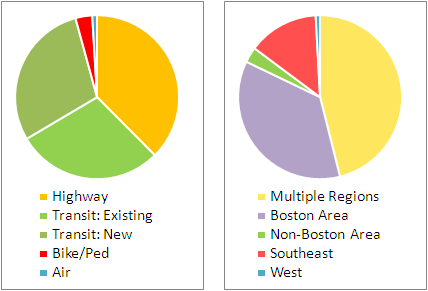
For now, I took the “wish list” and broke it down in two ways. First, I looked at each line item and what it funded: Air, Transit, Bike/Ped and Highway. I broke the transit out in to “existing” and “new” as the funding divides between improving existing services (such as replacing 40-year-old rail cars) and new funding for transit services which do not yet exist. This was a rough exercise, and certainly there is overlap (local highway funding will include bike/ped improvements, rail extensions will improve service on inner portions of the line) but it gives a good idea.

The second thing I looked at was whether each item benefited one region or multiple regions. This was even rougher. Some projects are statewide, some fund specific projects in multiple regions, and some are region-specific. The categories here were “Multiple Regions” (which includes statewide projects), “Non-Boston Area” (RTAs, mostly), “Boston Area”, and the West and Southeast parts of the state. There were no projects which specifically served the central or northeast regions, although they would be served in the statewide categories.

My quick takeaways:

  • More transit than highway, by an almost 2-to-1 margin.
  • No new highway construction—just rebuilding bottlenecked intersections. As far as I can tell, not even any highway widenings.
  • Bike/ped is a small percentage, but the raw number—$430 million—is quite big. Hopefully the $1 billion slated for local roadway improvements is mandated to create complete streets as well.
  • Most of the funding goes to the Boston area or the state as a whole; the big chunk for the Southeast is for the South Coast Rail project (and, yes, we can discuss whether that is a good use of funds later).
  • This is a pretty good start. Hopefully the highway lobby won’t throw up their hands and demand more roads, especially since bicycle and pedestrian projects create more jobs than highway projects.
  • This is a good start—but, yes, a start—towards tripling non-auto mode share in the Commonwealth (also see the linked article for Davey’s read-my-lips-no-new-superhighwas quote).

Mass. gas taxes lower than region, nation; parity would go a long way

I drove out to Syracuse over the holidays. When I filled up with gas in Massachusetts, the going rate ranged from $3.30 to $3.45, at least outside of downtown (where the cost of land and logistics raise the price somewhat). In Syracuse, however, most stations were in the $3.60 range, and I held my nose (although not too hard; I had borrowed a Prius for the trip so even a full tank ran under $30) and filled up.

And I got to thinking: why is gas in Massachusetts so much cheaper? I know why it’s cheaper than New York City, where gas stations take up precious land and you can’t build above them (because how scary would it be to live in a building sitting atop a bomb)? But upstate? Does delivery cost more? Are there some extra regulations in New York and not Massachusetts? Is the gas tax higher?
Oh, right, the gas tax is higher.
Massachusetts has a middling gas tax of 23.5¢ per gallon, 24th lowest in the country (and it hasn’t gone up in more than 20 years). New York’s tax is the highest in the US, more than doubling Massachusetts at 51.3¢. (Here’s Wikipedia on gas taxes by state including the federal 18.4¢ tax). New York’s economy seems to get along fine, and the gas taxes assuredly help New Yorkers fund their transportation network.
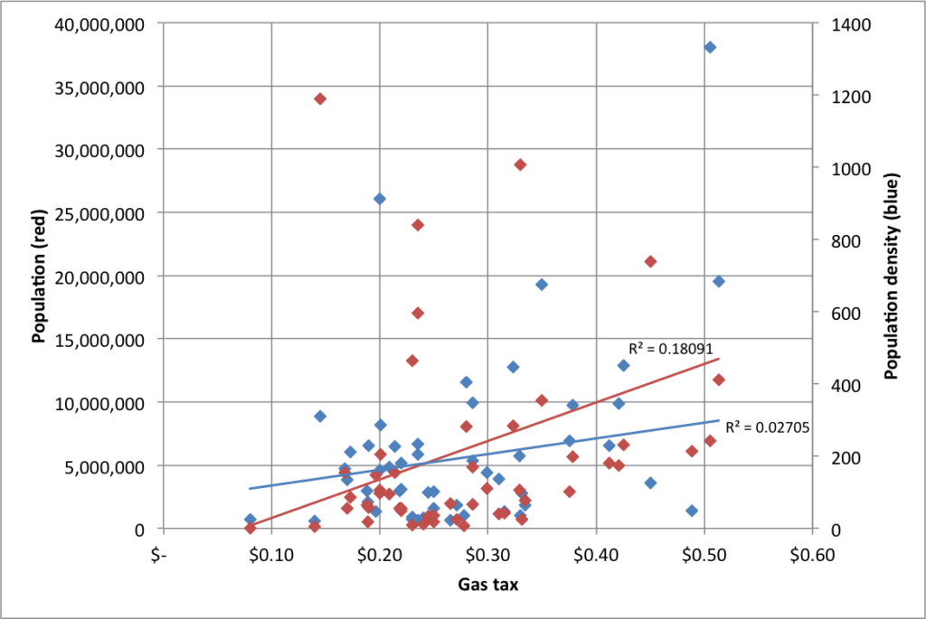
But Massachusetts lags even the national average of 27.5¢ per gallon. Gas prices are relatively well-correlated to state population (but, surprisingly, not by population density; see charts at the end of this post), so small, low-tax states skew this mean. Weighing the average by population shows that the average American pays a gas tax of 32.1¢ per gallon.
What about the region? How does Massachusetts compare against its neighbors, if not the whole country?
New York 
51.3¢
Maine
31.5¢
Connecticut
45¢
Vermont
26.5¢
Rhode Island
33¢
New Hampshire
19.6¢
Except for Live Free or Die New Hampshire, Massachusetts’ neighboring states pay higher gas taxes. Even in rural Maine and Vermont, where there are few transit options, gas taxes are higher. New York and Connecticut have dramatically higher taxes (putting thems in the top-10 highest gas tax states). Massachusetts seems like an anomaly here with lower gas taxes despite higher-priced neighbors and a transportation system which desperately needs the money.
The average in the region? 34.5¢. The weighted average? 46.7¢ (New York accounts for 71% of the population; Connecticut another 13%.)
Now, what would an increase gas tax would raise in Massachusetts? Last year, the MAPC put out a great MBTA budget calculator to try to close the gap in T funding. By their estimates, every 1¢ rise in the gas tax nets $27.7 million per year. Since even a 25¢ rise only accounts for a 7% rise in the overall gas price, we can assume that the gas tax wouldn’t decrease demand for fuel dramatically (demand for gasoline is quite inelastic). So here are some scenarios:
  • Match the national average of 27.5¢. Annual revenues: $110 million.
  • Match the national weighted average of 32.1¢. Annual revenues: $238 million.
  • Match the regional average of 34.5¢. Annual revenues of $305 million
  • Match the regional weighted average of 46.7¢. Annual revenues of $656 million
  • Match New York’s gas tax of 51.3¢. Annual revenues of $770 million
What if we raised the gas tax by 15¢ per gallon over three years—a nickel per year—and then did something really smart and indexed it to inflation? First of all, we’d still a ways from the top of the list of states by gas taxes. Three years out, we’d have somewhere along the lines of $400 million in additional gas tax revenue per year. I see this splitting in to five pots:
  1. MBTA operating subsidies. This could be 5¢ per gallon, although such a static cap could lead to issues if tax revenue lags like sales tax revenue did in the current budget predicament. Still, if there isn’t a huge debt transfer to the T (like there was in 2000) it would be less of a concern. (This 5¢ could also go towards Big Dig debt repayment, or that could come out of other portions of the tax.)
  2. RTA operating subsidies. 1¢ per gallon. Massachusetts regional transit authorities provide transit service to many cities and towns outside of the Boston area, and dedicated funding could allow them to improve and add service, as many operate limited schedules on only some days of the week. (The RTAs have less than 1/10th the ridership of the MBTA, so this is a higher per-rider subsidy and would help bring the votes of legislators from further afield.)
  3. Transit infrastructure improvements and projects. 4¢ per gallon. This money could probably be used to leverage private, local and federal funding.
  4. Highway infrastructure improvements and projects. 4¢ per gallon. This money would also probably help to leverage matching federal dollars.
  5. Bicycling and pedestrian improvements. 1¢ per gallon. It’s a small chunk of the puzzle, but $25 million per year would go a long way.
State policymakers in Massachusetts seem to realize that something has to be done about transportation funding. In the midst of the recession, business leaders called for a 25¢ gas tax hike. In 2009. 25¢ would give another $300 million per year for things like infrastructure improvements and debt payments (although it would still fall short of some estimates of the need for infrastructure improvements). This is the kind of sensible changes that we will need in order to have a functional transportation system. And if we look to our neighbors, we can see that, despite concern trolling (this article has a sad story about a guy filling up his wife’s Lincoln Navigator who might get hit for $500 a year—but apparently can afford to own and drive a 16 mpg Navigator) that always bubbles up when the gas tax is mentioned, raising the tax enough to begin to pay for our transportation system is certainly feasible.

As mentioned above, here’s a chart of gas taxes by population and density:

A quick note on Vehicle Miles Traveled taxing, or VMT: it may be a more palatable alternative to gas taxes, but it’s bad policy. First of all, it would require significant infrastructure to require people to have their odometers read, probably at a state inspection. It would also incentivize people to register their cars out of state, which is not a particularly difficult thing to do, especially for a state with a lot of migration in and out. Finally, a VMT tax disincentivizes driving, while a gas tax pulls double duty and discourages driving and the purchase of larger, less efficient vehicles. In other words, there is no logical argument for a VMT over a gas tax.

Witches and Networks

A couple items of note from the Boston Globe today (one pay-walled, one not):

1. This summer, we posted on the well-used but ill-marketed weekend train service to beaches on the MBTA’s Newburyport-Rockport line. This past weekend, and this coming weekend, the T is adding several trains on that line. Why? The line goes through (quite literally, in a tunnel) Salem, that of witch trials and general spookiness. Hallowe’en is big business in Salem, with the monthlong “haunted happenings” peaking on the last two weekends of the month. With roads closed and parking limited, the city actively promotes the use of public transportation, and the T obliges. (Oh, and parking gets a lot more expensive. Supply et demand.) With the city backing, the train schedule is more than doubled on weekend afternoons.

Obviously, there’s capacity on the line (which handles nearly no freight—the main choke points are Beverly Junction and the aforementioned one-track tunnel through Salem). Why is there no extra service in the summer? There are probably a couple of reasons. Salem wants as many people as to come as possible—at least before Hallowe’en evening when things can get rowdy. More feet on the ground means more dollars in the coffers. The beach towns are not likely pressing the T for more people to crowd the beaches. They’d be glad to charge drivers $25 to park, but only until the lots are full. Otherwise, there’s not a lot of money to be made on beach admission. Second, the witch tourism is planned far in advance and not very weather dependent (although it likely drops off in case of rain or—this year, apparently—snow). A rainy day does not see many beach-goers. Still, there’s no reason the T shouldn’t at least promote the beach service they have in the summer, even if it’s not to the extent of doubling spooky service.

2. There was a very interesting event on the T yesterday: a startup meetup in the last car of a midday Red Line train. (The Globe article is paywalled and I can’t find a free link. Update: here’s a free link) Apparently, a bunch of local startup firms all met on the Red Line, had short speeches between stops, and then networked. Great idea! As one of the top venture sites in the country (although lagging behind Silicon Valley) many of these types are already on the Red Line every day, so what a good way to get people together. Now, if only we could have rational development policies which did not underprice suburban office parks and pull these companies out to Waltham and Burlington, where innovators spend way too much time behind the wheels of their cars.

Which reminds me … this year, I’ve been tracking my travel. Every day, every mile, every mode. Seriously. I have a spreadsheet, and every month I post a “transport report” for that month. (Here’s January; you can click to subsequent months.) At first, I had no idea what I’d use the data for (other than fun charts. hooray fun charts!). But now I have some ideas:

v 0.1: Manual data entered in to a Google Doc, manual charts made in Excel
v 0.2: Once I figure out how to make PHP and JPGraph work (any help would be appreciated, seriously), have the charts update live from a Google Doc / database when the data is entered
v 0.3: Open this to other transportation geeks who want to provide this type of data, and see if it works—and what happens. When you think about every mile you travel and every mode, you tend to drive less.
v 1.0: Track transport and mode using smart phones (doable, I think, based on discussions from Transportation Camp last spring) and gather data, and develop a social network based on where people are and when. What do you do with these data? All sorts of things. Like:

  • Real-time updates about traffic and transit problems sent to people based on their past behavior (i.e., we know you take the Red Line or drive Route 2 between 8:15 and 8:25, but there’s a disabled train / traffic accident, so you should consider the #1 bus / going to Alewife instead)
  • Helpful hints to help people drive less. A system could weed out short trips which could be made by foot or bicycle. Or help people link trips together. Or even take shorter routes.
  • Let people meet others with similar commuting patterns. If enough people used the system, it might be able to pair drivers in to car pools (“we’ve determined that you and another driver have each driven alone from the same neighborhood to the same office park with 15 minutes of each other 23 of the last 27 days—here is a link to send them an email/fb message/tweet to try to form a carpool.”) or meet people on the train or bus. To make the solitary confinement of a crowded train less—well—solitary. This would be optional, of course, but could be very powerful
  • Provide really interesting data to planners on who is going where, when and by what modes.
Obviously, some work needs to be done. But it’s an idea. If you have any ideas for it, or want to be notified when I get the system off the ground (or even close to that phase) watch this page or email me at ari dot ofsevit at gmail.

200 feet of grass roots

I went for a run yesterday, and as usual observed interesting things at eight miles per hour (as opposed to double that speed on a bus or bike). As I ran along Kent Street in Brookline, I saw someone ahead of me reach towards a vine-covered fence and pick something. I’ve often loved finding wild-growing berries in the urban landscape (which reminds me: black raspberries along the Minuteman Rail Trail are in season!) but this didn’t appear wild—a strip of vegetation climbing a chain link fence between the sidewalk and the parking lot.

It’s not. In fact, it’s a project called the 200 Foot Garden. A couple of local residents saw the shabby patch of land and decided that they’d like to plant it, so back in 2009 they got permission from the property owner to landscape and plant the section of dirt (and, as he points out, save them the cost of landscaping). Once the fence was replaced, he helped to create a peculiar sort of community garden: one where anyone can take the produce. That’s right, anyone. I spy tomato plants, and I’ll be stopping by. (Now, I wonder if these are heirloom varieties. We’ll soon find out.)

The sunny patch seems to grow vegetables well, and while it’s actually only 180 feet long, 360 square feet of open space is a rather large plot in this part of Brookline, which has a population density of more than 25,000 per square mile (that’s double the city of Boston, and about equal to New York City). 25,000 people per square mile is about one person per 1000 square feet, so this unused plot of land, in this neighborhood, was akin to the land used by a third of a person. Or, to put it another way, with a three bedroom apartment going for more than $2000, the rent for this land would probably be around $200 per month.

What’s particularly splendid about this little garden is that it is a completely grass-roots, under-the-radar example of urban design. Mayor Bloomberg did not block off the street (while there are surely many Bloombergs in very-Jewish Brookline, none will ever be mayor—Brookline is, officially, a town, and it doesn’t have a mayor) for pedestrian use. There’s no 200 foot garden conservancy, no gala fundraisers, no executive director. Just an idea, a letter to the owner and some discounted vegetable plants from a local farm. And with surely thousands of similar weird, underused plots of land around, it’s an idea which could grow.

The peculiarity that is Brookline

If you were dropped in to Coolidge Corner at noontime and I asked you to tell me two peculiar things about the encompassing community, you’d have trouble picking out the two of which I was thinking. Coolidge Corner is the retail center of Brookline (although stores radiate along several streets) and is also bisected by the Green Line light rail (Coolidge Corner happens to be the system’s busiest surface stop, with 4000 boardings daily) and the 66 bus line, one of the busiest in the system, with more than 10,000 daily riders. It’s typical turn-of-the-century mixed use, with street-level stores and apartments and offices several stories above. There are no skyscrapers, but there are several buildings which, at ten and twenty stories, would not look out of place on Manhattan’s Upper West Side.

And if you go a mile in any direction, you remain in density. There are brownstones and row houses and the ubiquitous triple decker, and courtyard apartments and more recent taller (and elevator-serviced apartment towers). There are streets (particularly up nearby hills) with single family houses, but few sprawl over much space. Less than a mile north, another light rail line skirts the border with Brighton in the median of Commonwealth Avenue; to the south, a third spoke of the system runs along a grade separated right of way making fewer stops but at higher speeds since it is not at the mercy of the stop lights.

As far as municipalities go, Brookline is fairly dense: about 59,000 people live in just under 7 square miles; more than 8000 in any given square mile. But it is very unevenly developed. North of the Green Line’s D-Line (the southernmost of the transit lines) and Route 9 is the housing described, but south of it, in an area encompassing about four square miles, single family homes, many of them large estates, and golf courses are the rule. If you exclude the southernmost two census tracts, 47,000 people live in 2.5 square miles (18,000 per square mile). If you take out the two tracts straddling this Route 9-Green Line line, the population density of the remaining 2 square miles is over 20,000, with some tracts peaking towards 30,000.

Brookline is not very diverse, being 80% white (and 12% Asian), with large Jewish and Russian-speaking communities. The schools are only two-thirds white, and the 2010 data (which are not on Wikipedia yet) show somewhat more diversity. It’s also quite wealthy, with low poverty rates and high housing prices, although there are 2000 affordable units and many rental properties with rents similar to neighboring cities.

So, what’s peculiar about Brookline? Well, if you were to walk a few blocks south of Coolidge Corner, you’d get to the town hall. Not to the city hall. Brookline is not a city. (I’ve judiciously avoided using the word “town” to describe it thus far for effect.) There’s no mayor. There are selectmen (they serve as the executive) and a representative town meeting (with 240 members, which serves as the legislative branch).

And if you walked a block down any side street in Brookline later in the evening, you’d assuredly notice the other peculiarity: There would be no cars parked on the street. Brookline bans overnight, on-street parking. During the day, the whole town is two hour parking (and it is enforced). Finding parking in most of the dense parts of Boston (and Cambridge and Somerville) is not an enviable task. In Brookline, it’s easy, provided you don’t want to stay for more than two hours.

We’ll discuss more about Brookline in coming weeks (I lived here last winter and am back for the summer) and explore how these peculiarities help shape the town.