Longfellow Bike Count: Year 2

It’s kind of hard to believe that it’s been more than a year since my first Longfellow Bridge bike count, but it has. I’ve posted just a few times since then about the bridge, and seen the inbound lanes deconstructed, the towers come down, and, arch-by-arch, the bridge is now being rebuilt. I even went out in the middle of winter (and by out, I mean in to someone’s office with a view of the bridge) and counted about 90 bikes per hour: 30% of the previous summer’s crossings. (I think I tweeted this during the winter but didn’t write a whole post.)

So it was high time for a new count. I waited for a morning with good weather (and when I wouldn’t miss November Project) and set off for the bridge. After chatting with the DPW workers on my street about Hubway, I didn’t make it on to the bridge until 7:45, but that meant I was there in plenty of time to hit the peak morning bike rush hour, which (still) occurs from approximately 8:10 to 9:10 on the Longfellow. While at first the bike counts seemed flat or even down, once the rush got cranking, it became clear that there are more bicyclists this year than last.

Just to review, here are the bike counts for the peak hour from last year:

Wednesday, June 19, 2013: 267 bicyclists (8:12 – 9:12)
Tuesday, July 30, 2013: 308 bicyclists (8:08 – 9:08)
Tuesday, October 15, 2013: 298 bicyclists (8:11 – 9:11)

Here’s what I found this June (on the 24th, a Tuesday). The counts today peaked from 8:07 to 9:15 (that is to say, the 8:07 – 9:07 hour and the 8:15 – 9:15 hour saw the same counts). And the number of cyclists during those 60 minute blocks?

384

That’s one bike every nine seconds for an hour. Compared with the highest count last year in July, it’s an increase of 25%. Compared with the average of the three counts last year, it’s an increase of 32%. In a single year.

I can’t think of any single factor that would have increase bicycle usage by that much, other than more people riding bikes. So, contrary to any mitigating factors, I’m operating under the assumption that bicycling eastbound across the Longfellow is up by at least 25% this year. Between 8:30 and 9:00, there were 221 cyclists crossing the bridge and only 187 vehicles: 18% more bikes than cars. There were a few moments where the bridge looked downright Copenhagenish. With more bicyclists than vehicles crossing the bridge at peak times, perhaps it’s time to revisit the design and give bikes more than 20% of the road’s real estate.

The new Blue Book is out

Every few years, the MBTA publishes the Blue Book. It is a compendium of data, neatly packaged in a PDF format. (It would be nice if they published a Blue CSV, but that’s asking a lot of a public transit agency.) I haven’t had much time to play with it, but did download the data for the core subway lines, to compare 2013 to 2009 (the last Blue Book) and before.

This shows data for each subway line (N.B.: it only shows subway boardings for the Green Line) for the past 25 years. The Red, Orange and Blue lines all grew by 13% since 2009, and compared to their lowest count over the past quarter century, they are up 67%, 38% and 82%, respectively. All three lines saw their highest ridership in 2013. If the trains seem crowded, it’s because they are carrying significantly more riders now than they were just a few years ago.

Then there’s the Green Line. It seems that ridership there is flat, but I haven’t had a chance to look at the branches. It might be due to it’s slow speeds, arduous boarding process, arcane rules, lack of traffic priority or a combination of these factors. Or it could be that it’s already basically at capacity, at least as currently configured.

I’ll have more analysis—including station-by-station counts (very variable) and bus routes (they’re growing)—in the coming days.

What’s wrong with this picture?

A simple question: What is wrong with this picture?

The answer: the cars have a green light to go straight, but the pedestrians have to wait. This signal is optimized for vehicle movement, at the expense of the safety and convenience of pedestrians. Considering that this is an area with high pedestrian use—at the northern end of the BU Bridge along the Paul Dudley White bike path—it is nonsensical that such priority is given to vehicles rather than pedestrians. The only way to get a “walk” light is to push the “beg button” on either side of the crosswalk—otherwise the light stays at “don’t walk” encouraging drivers to make the turn without looking for pedestrians.

But it’s worse. Look to the right. There’s a second traffic light showing green. Cars driving a downgrade are encouraged to make the turn as fast as possible (the tapered corner doesn’t help), at the expense of the pedestrians. Want to cross? Wait until a red light. Although it’s not like that will even help that much: cars can still take a right on red (after “stopping”).

What could be changed to make this intersection safer?

  1. The once-you’ve-turned light should be removed or relocated. Right now it is too far around the curve. By the time a driver sees it in its green phase, they are already crossing the crosswalk. In its red phase, a driver who had missed the main signal would have already crossed the crosswalk. It could be replaced with a “yield to pedestrians in crosswalk” sign.
  2. The walk signal should be changed to display a “walk” sign with every green phase of the light. This will allow for safer pedestrian movement and will not relegate pedestrians to play second fiddle to automobiles at this intersection. It could be enhanced with conspicuous “yield to pedestrians in crosswalk” signage.
  3. At slightly more cost (the first two items would simply require reprogramming or removing the lights) the curb should be bumped out to create more of a right turn movement. This will require vehicles to slow down as they make the turn to cross the crosswalk, which will allow them to better look for pedestrians crossing from one side of the roadway to the other.

This is traffic calming at its simplest: traffic throughput will not likely be curtailed (the bottlenecks in this intersection are not due to this light, but are at other locations) and it would significantly enhance conditions for more vulnerable road users.

Red-Blue connector: think outside the tunnel

We recently wrote about the obscenely inflated cost of the Red-Blue Connector. And while the underground costs are certainly inflated, it still involves building a tunnel underground, in loose fill, under a busy street, and then building connections in to an existing station. It would still involve months- if not years-long lane closures, massive utility relocation, and underground station construction. It might be heretic to say so, after Boston has mostly removed above ground transit, but in this case, an elevated solution might be the best solution possible, and not just because it would be cheaper (which it would be).

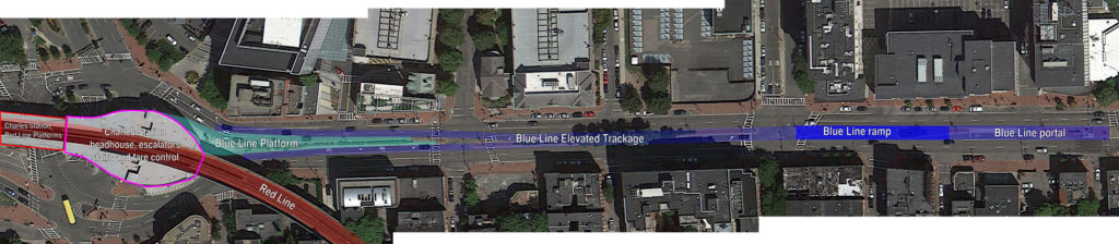
First, the logistics. The Blue Line tunnel currently ends several blocks east of Bowdoin Station. The original portal was between Joy and Russell Streets (at Nims Square, one of Boston’s lesser-known squares). Here’s an aerial photograph of the portal; you can see that it is several blocks east of the curve at Bowdoin Station. Most likely, the tracks were capped just east of Joy Street, and the portal filled with dirt and built over. Most likely, it still exists.

And most likely, it could be easily opened. The cheapest option would be to run the Blue Line straight down the center of Cambridge Street at grade, but for a litany of reasons that, uh, wouldn’t work. But instead of coming up from underground and flattening out, it could continue sloping upwards and, by Blossom Street, enter an elevated guideway above Cambridge Street. From there, it would continue a few hundred feet and terminate at a two-track station with a center platform above Cambridge Street, adjacent to the current Charles Station.

Click the diagram below to enlarge. All lines are to scale.

There are many, many advantages to an elevated solution. They include:

• The portal exists! There may be some utilities buried there, but not likely major infrastructure; it’s probably mostly just fill.

• The portal is built in to the side of Beacon Hill. As the tunnel rises to the surface, the surface falls away. This limits the space that a ramp takes up for the transition from underground to elevated. In addition, because the Blue Line does not require overhead wiring, the tunnel height is lower—and therefore the floor is higher—reducing the amount of climb necessary. A similar subway-to-elevated transition exists for Green Line trains between North Station and the Lechmere viaduct. The distance between the portal and where the viaduct passes over the ramps from the Leverett Circle is conveniently the exact same distance as from Joy Street to Blossom Street on Cambridge Street.

• Once above the street, the viaduct will be quite narrow. Since the East Boston tunnel was originally built for streetcars, Blue Line cars are narrower than, say, Red Line cars. The elevated portion of the Green Line between North Station and Lechmere—especially the new section east of Science Park—is a good guide to the width, although with no need for overhead wire, a Blue Line viaduct could actually be built narrower than the Green Line.

• Charles Station could be built to serve the Blue Line with no added mechanical equipment, and minimal changes to the station. There are already wide stairwells, escalators and elevators in Charles Station which bring passengers from street level to the Red Line. The Blue Line would simply be a platform accessible from the current outbound platform, and would not require any additional infrastructure. Unlike other transfer points in downtown Boston, Charles Station was recently rebuilt, and passages are wide enough for significant additional traffic. An underground station, with additional elevators and escalators

• An elevated Charles Station would require transferring passengers to climb and descend fewer stairs than an underground solution. Imagine a round trip from Cambridge to East Boston. For an underground station, passengers would arrive on the Red Line, descend to street level and then down to the underground, reversing the trip on the way back for a total of four flights of stairs. For an elevated solution, the morning would require two flights—down to street level to cross under the Red Line and then back up—but the evening would be a level transfer, halving the vertical distance each passenger would have to travel.

• While Cambridge Street abuts the historic Beacon Hill neighborhood, it is generally bordered by newer construction, and in many cases by parking lots. The street runs east-west, so most of the shadows cast by an elevated structure would fall on the north side of the street, which is mostly occupied by Massachusetts General Hospital, and in several cases by parking facilities. As a major beneficiary of the project, MGH would likely be willing to have some shadows cast in exchange for far better accessibility. In addition, Cambridge Street already has an elevated structure at Charles Circle, so it is not an entirely new concept to have overhead transit in the area.

• A fire station would likely have to be relocated from the south side of the street between Russell and Joy Streets as they would no longer be able to take left turns across the subway-elevated transition. However, it could be moved to parking facilities on the other side street near MGH, and integrated in to new construction. For instance, a fire house occupies the ground floor of a skyscraper in the Financial District.

• Elevated construction and stations are far less expensive to build than underground. And far less distuptive. While an underground structure would require years of lane closures on Cambridge Street, an elevated structure would require only supports to be built in ground—and those would be in the median. Most of this work—exploration, utility relocation and the pouring of the concrete—could take place outside of rush hours, and the actual viaduct could be built off-site and placed on the pedestals, with minimal interference with local traffic. If the area can survive a three-year closure of the Longfellow Bridge, it could deal with a few short-term lane restrictions.

At $100 million per mile, the elevated section would cost less than $50 million to build. Since the station would be little more than a concrete slab between two tracks—no need to install multiple elevators, escalators and fare control—it would not appreciably add to the cost. It’s entirely possible than an elevated solution could be built for under nine figures, far, far less than the state’s estimate for an underground connection.

• This project would require few—if any—property takings. The only street-level construction would be supports for the elevated, and these could be built in the existing median on Cambridge Street. Again, the supports for the Green Line connection between Science Park and North Station is a good case study; the base of the concrete pedestals are only five feet wide.

Building a Red-Blue connector is something which would dramatically enhance Boston’s transportation network. It would increase ridership, reduce congestion downtown, and provide better employment access for a large part of the area. It would also utilize the only portion of the downtown network which is under capacity—the Blue Line—and allow it to better serve the traveling public. And while the state may be set on inflating the price to high that it will never be built, a compromise solution using as much existing infrastructure as possible could be built more quickly and far less expensively. It is a solution the city and state—and stakeholders in the area—should seriously consider.

Red-Blue Connector: It costs how much?

The Commonwealth of Massachusetts is supposed to build a connection between the Red and Blue lines. But they really, really don’t want to. It’s probably a very good idea, since it will increase mobility for Blue Line riders accessing jobs in Cambridge. And it will take some of the capacity crunch off the core subway lines where Red-Blue transfers take place. And it will improve access to Logan Airport. And it will shorten trips for thousands of commuters each day who will no longer have to transfer twice, in already-crowded downtown stations. There are definitely benefits. And the state is supposed to build it.

They’re doing their best not to. They’ve claimed that the construction would cost $750 million, which has been called “deliberately high.” How deliberate? The costliest subway project in the country—the Second Avenue Subway in New York—costs 1.7 billion dollars per mile. The Red-Blue connector is 1500 feet long. Less than a third of a mile If you do the math, it comes in at $2.7 billion. That’s not even in the ballpark. It’s an obscene figure and is risible. It shows the state does not want to come close to making a good-faith effort to support this transportation connection.

How much would it cost? Well, likely far less. The current Blue Line tunnels extend underneath Cambridge Street to a former portal at Joy Street. Continuing the tunnel would certainly be disruptive, but could be done in a cut-and-cover method without fully disrupting traffic flow (the street is five lanes wide including the median, and the subway would only require two). Utilities would require movement, but there would be no need to support an elevated roadway or surface train lines above (like the Big Dig). Traffic on Cambridge Street would suffer for a time, but better transit service in the end would be worthwhile. Alon Levy has a compendium of subway construction costs, and most projects fall under $1.5 billion per mile.

A good analog might be the Central Subway in San Francisco. It’s a short extension of a light rail-sized transit line (as is the Blue Line; the East Boston tunnel was originally built for streetcars so it’s a much smaller gauge than, say, the Red Line) extending to a terminal station in a dense city. It is budgeted for $800 million per mile. If the Red-Blue Connector was built for the same cost, it would come in around $250 million. Or a third of the cost the state estimates.

The $750 million figure is not disingenuous. It’s a lie. And an elevated connection—with only a few hundred feet of elevated structure—could be built for a fraction of the cost with a better final product, to boot.

A response to the DCR anti-bike statement

Recently, UniversalHub posted an exchange with the DCR regarding winter bicycling maintenance. I’ve seen this as an issue before, but the derision with which the DCR views cyclists is repugnant. I’ve been stewing about this all morning and have posted a line-by-line rebuttal to the last directive which really makes my blood boil. Not only is it derisive and dismissive, but it shows how little the DCR cares about anything that doesn’t have four wheels and an internal combustion engine. I am going to go through it sentence by sentence and provide notes, in italics:

We should all be stating as a policy that DCR has no responsibility or intent of providing “safe” winter biking opportunities on any of our linear paths or sidewalks. 

Since when is this the DCR policy. Is there anything in state statute that directs them not to maintain safe winter conditions on their linear paths or sidewalks? Or is this an internal policy decision.

This is impossible! 

Simply not true. There are several examples of paths which are plowed and maintained in Boston. These include the Minuteman Bikeway, which is maintained by the towns it passes through and well-used. The Somerville Community Path is similar. MassDOT should be applauded for their efforts to keep the Longfellow clear of snow; they have done a stellar job and shown that it certainly is possible to provide a clear path for non-auto users. Additionally, if you look at cities like Madison, Saint Paul and Minneapolis, they have no issue keeping paths trails for cycling. It’s been above freezing in Minneapolis 8 days since December 4. So don’t give me the “it’s too cold in Boston.” It’s been below 0˚ 42 days in that time frame. Spare me.

Any path or walk where we do snow removal is strictly to provide reasonable continued passage for pedestrians.

Why is the level of maintenance between these paths and the parallel roadways different? The roadways are pleasure roadways, yet they are maintained to the same level as any other roadway. If the DCR ran a single plow after the storm and let drivers fend for themselves, I’d understand them not clearing the pathways. However, that is not the case.

If anyone wants to bike our paths in winter they should assume variable and dangerous conditions, and know they are doing it at there own risk.

Then why call them bike paths? The Paul Dudley White Bike Path is called a bike path because it is a bike path. The Soouthwest Corridor is explicitly signed for bicyclists. We understand that paths might not be free of ice and snow, much like we understand that roadways may have patches of ice and snow on them. However, we expect that when we pay tax dollars these go towards maintaining the pathways—putting some effort in to it. It is clear the DCR does not feel that this is the case.

Frankly, I am tired of our dedicated team wasting valuable time addressing the less than .05% of all cyclists who choose to bike after a snow/ice event. 

Wow. Where to begin. First of all, the DCR is spending a lot of time defending not doing any work. How about spending some of this energy going out and actually clearing off the snow from their properties. Then they wouldn’t have to waste this valuable time. Second, 0.05% of cyclists choose to bike after a snow/ice event? This is ridiculous. It’s possible someone here doesn’t understand math and meant 5% (0.05 is 5%, but 0.05% is 0.0005). They are saying that one in 2000 cyclists bikes after a snow event. I was out cycling this past week and rode with a group of five bicyclists on Main Street in Cambridge. By this calculation, there would be 10,000 cyclists on Main Street on a given morning. I can tell you that is not the case. This is dismissive and wrong. 

Sometimes during winter in Boston you can safely bike, and I do it when it is dry and safe. 

False equivalence. Do we say “sometimes you can drive in Boston, when it is dry and safe?” And just because you don’t does that mean that no one should?

This is not one of those winters! 

Please go out and stand on a street corner in Boston and see if there are any safe cyclists. I can attest that there are many.

We should not spend time debating cyclists with poor judgement and unrealistic expectations, and stick with [the staffer]’s recommendation that they find other transportation.

Cyclists who want to be able to bike in the winter have poor judgement? Do drivers who drive in the winter have poor judgement? And is it really unreasonable to expect that bike paths designated as such would be maintained for bicyclists? If this staffer believes that this is the case, they are derelict in their duty and should be removed from their position.

If someone is completely depending on a bike for year-round transportation, they are living in the wrong city.

This is repugnant. The state has a goal of reducing SOV travel, but apparently the DCR is not on board. It is time for the DCR to work with the rest of the Commonwealth, not against it. And if Boston is the wrong city to be a cyclist in the winter, perhaps we should move to Minneapolis or Madison, a city with worse winters, but which actually invests in its cyclists.

Design in isolation

There are several recent projects in the Boston/Cambridge area—some of which have been covered on this page—that have been in the conversation recently. One major flaw of all of these is that they do little to combine the features of multiple projects but rather are viewed in isolation, even though they often border each other and, in many cases, deal with the same roads, paths and transitways. These include:

These are all worthy projects, and it’s mildly infuriating that there is no overarching planning agency which can corral these in to one cohesive plan. Right now, it’s an alphabet soup which includes MassDOT, DCR, Cambridge, Boston, the MBTA, Harvard and MIT (they own part of the Grand Junction right of way). The issue is that these projects are often viewed as singular entities, and not in relation to the greater transportation ecosystem. For instance, I see the Allston campus, Cambridge Street Overpass and Turnpike Straightening as inextricably linked, with no small connection to the DCR paths and, down the line, the Bowker overpass. A vehicle driving over the Bowker Overpass may well have come from Harvard Square, via a DCR roadway and through the Turnpike interchange. And, heck, with better transit or bicycling connections, that vehicle might not be there at all. 
Instead of single-item traffic studies, we need to take a holistic view of the transportation infrastructure in the region, and decide what we want to see in 20 or 30 years: slightly realigned roadways which still prioritize funneling as much traffic as possible to the detriment of other uses, or a more complete transportation system. Most of the infrastructure in question is 50 or more years old, and will need to be rebuilt (or reconsidered) in coming years. Instead of rebuilding the broken infrastructure we have, we need to take a broader view of what we could create. Since we’re going to have to spend the money anyway, we might as well spend it wisely now, rather than have to fix yesterday’s problems tomorrow.

This page will attempt to do so in the near future.

Anecdotes in the Globe

When I write a letter to the Globe—which happens relatively often, it turns out—I try to throw something more than a personal anecdote in. I figure they don’t want to hear my story in response to Joan Vennochi’s (hers: “I was in traffic and a bike passed me, therefore I hate bikes”), but want me to add something their readership might be interested in. So I pick out one of her more ridiculous points (“We need more parking spaces for cars and fewer for bikes so people can go shopping.”) and show why it’s folly.

Which is why a couple of recent letters to the Globe regarding the DMU plan are dismaying. They get the gist of the argument right, but they anecdotes they use seem to say “look at this transit system we have, it’s so bad that I can’t use it because _____.” Except the fill-in-the-blank of that blank is a single personal experience which is not really verifiable. (I, at least, cited a study.)

Here’s letter #1. Nathan Banfield from Concord writes about taking the train from Concord. “I can drive to Porter Square from my home for, at most, $4 in gas, the same trip costs twice as much by commuter rail while taking considerably longer.” Let’s examine this. Yes, it’s $4 in gas. Then what do you do when you get to Porter? You park—somewhere. Probably at a meter. That costs money. A garage? That costs more. And if you factor in only the cost of gas, yes, it’s probably cheaper to drive. I think the 55¢ per mile (or whatever it is these days) figure quoted for cost per mile is high (it figures in fixed costs like insurance and assumes you have an expensive—and more quickly depreciating—vehicle) but it’s certainly more than the cost of gas alone.

But, oh, Nathan. Taking the train takes considerably longer? You picked one of the commuter rail lines where that’s not actually the case! The drive from Concord to Porter takes 22 minutes. If there’s no traffic. The train? 27 for an express, 34 for a local. That’s longer, but not by too much. But what if you happen to drive Route 2, say, between 6 and 10 a.m., or 2 and 7 p.m.? All of the sudden the 27 minute train ride seems like a breeze since you might spend that long waiting through the lights at Alewife. Yes, frequencies should be better. And, yes, on weekends it’s probably faster to drive. But for commuters, the train is certainly faster than driving, especially along Route 2.

The award for taking a single experience and mistaking it for data, however, goes to letter #2. Sherry Alpert writes in from Canton. “I’ve been riding these trains for 30 years” (reminds me of this Seinfeld clip). Good for her—and she doesn’t even try to claim that the train is so much slowed than driving. So, on January 8, the train was an hour late, and she missed a class. Therefore, the trains are unreliable. That may be the case, but just one late train on January 8 does not mean the train is always late. And would you rather drive at rush hour from Canton to Boston? Because that’s always going to take an extra hour. Again, the sentiment that more reliable service is understandable, but stating that the system is unreliable because one train was an hour late is like saying “traffic is really bad because I got stuck in one traffic jam.” If you get stuck in a traffic jam every day, then, yes, traffic is bad. If you get stuck in one specific traffic jam because, let’s say a tractor trailer jackknifed, then traffic is not bad—there was an accident.

Now, if only there was somewhere to see the MBTA’s arrival data. Some sort of, I don’t know, monthly scorecard. Oh. Wait. The MBTA has a monthly scorecard. You know what doesn’t have this kind of monthly data? The highways. But no one is writing letters saying “it took an hour to drive 12 miles on 128 today.” Because, frankly, that’s not really noteworthy, except maybe on Twitter. Which is where complaints about your train being delayed belong, anyway. But not in the newspaper.

Massachusetts’ DMU plan could well provide better rail service

Last year (oh, wait, in 2012—gosh) I wrote about the sorry state of affairs of the MBTA’s commuter rail system. Outside of rush hour, trains travel infrequently and on seemingly random schedules. Even in closer-in, denser areas, service is provided only every couple of hours. (Oh, yeah, and service is slow, too.) There is probably demand for better service but little supply, and it’s partially a cost issue: running full, 1000-passenger commuter trains (with poor acceleration) is a losing proposition when few seats are filled.

Enter the DMU. The diesel multiple unit, while sparsely used in the US, is a frequent sight abroad, providing service at times when a full trainset is not needed. They leverage the direct connections between town centers that exist along rail lines, allowing fast service to the city center without rolling empty cars through the midday and evening. The plan imagines several lines utilizing DMUs on rail segments inside 128—most of which do not have paralleling subway service:

 (The full report, which appears to have been scanned as a PDF, is here.)

If implemented, this would go a long way towards improving service on several underserved corridors. The Fairmount Line currently is served infreqently by full-length commuter trains, a complete mismatch of service. Lower capacity and better acceleration would provide a much better benefit there. The Worcester Line—which will soon have added service—provides very little service in Newton, the most densely-populated portion of the line (it is served by express buses, which crawl through traffic on the Turnpike). Better service to Lynn will provide some of what a far-costlier rapid transit connection would—faster and more frequent service to Boston, and service to Woburn will provide better connectivity north of Boston, as well as further reducing the run times for trains to Lowell, currently one of the faster trips in the system, and one which, if the state of New Hampshire pays, could be extended northwards to the granite state to provide an alternative for the traffic-choked I-93.

The most interesting piece here is the inclusion of the Grand Junction through Cambridge. This page would argue for a complete rebuild of this line, with grade separation and electrification, and its operation as a crosstown link between North Station, Cambridge and Allston, currently a serpentine trip by car, much less by transit. It also would provide better access to the fast-growing Cambridge area which is currently poorly-served by highways and at the whim of the over-capacity Red Line. Currently, commuting from west of Boston to Cambridge is a bit of a black hole; there is no good connection between the Worcester Line and Cambridge without going all the way to South Station and backtracking across the Red Line. The Grand Junction is an underutilized piece of infrastructure which could be put to very good use.

What really matters is how the MBTA decides to implement DMU service. (That is, if it can be funded and overcome local opposition; double-dipping Cambridge City Councilman and State Rep Tim Toomey helped to quash a plan to route some commuter service over the Grand Junction in 2010. Needless to say, he did not receive my vote in recent council elections). If it uses it as a cost-saving measure to run the same level of service with less equipment, it will simply maintain the status quo. For instance: there are only eight commuter rail trains from the stations in Newton to Boston daily. And the Fairmount Line has 60 minute headways with no evening or weekend service. Running the same level of service with different equipment would be a wasted opportunity (if a minor cost savings).

If the state provides faster and more frequent service to these lines, say, with 15 or 20 minute headways all day, it will come much closer to providing a transit level of service, and actually providing service to these communities. With new stations at Yawkey, near New Balance and the intermediate “West Station” the Worcester Line would provide better connections through an underserved portion of Boston and Newton (with frequent, timed shuttle service across the Grand Junction a dramatic bonus). And the Fairmount Line, which currently provides piss-poor service to one of the states most disadvantaged communities, could prove an economic lifeline, if only the trains ran more than hourly.

And if DMUs are successful, they could be implemented in other parts of the system. Why run a full trainset at off-peak hours from Newburyport to Boston when a transfer at Beverly would provide the same level of service? Perhaps instead of the hourly locomotive-hauled train from Boston to Lowell, half-hourly DMUs would double the service at a minimal additional cost. Perhaps DMUs could provide service further west of Worcester to Springfield and Amherst. Hopefully, the state sees DMUs as a tool, not as a cost-cutting measure. If they implement this service better than they photoshopped the map, they could dramatically improve travel in Massachusetts.

MBTA still won’t provide real all-night transit

The MBTA recently announced a pilot program to extend service hours on Friday and Saturday nights. This is a great step for the T, which hasn’t had subway service after midnight in over 50 years. While it does reduce the amount of time the T will have to inspect and fix its aging infrastructure, the other five nights will still have time for track work, while serving the busiest nights for late-night ridership. This is all good.

What Boston will still lack is an actual late-night transit system.

In every other major transit city in the country (More than 25% mode share: NY, Chicago, SF, DC, Philly or more than 1m daily ridership: LA), there is an option for getting around between midnight and 5 a.m. Not just on weekends. Not just until 3. (DC is a slight exception, some overnight bus routes shut down for 30 to 120 minutes around 3:00; but some routes, like the 70, have no more than an hour gap in service.) Service may only come every hour, and it may be a bus instead of a train, but if you need to get somewhere at 2 a.m., you might be able to take a bus there. This is not the case in Boston, and even with added Friday and Saturday night service, it still won’t be. Several smaller cities operate all-night transit systems as well.

Late night transit service is going to cost money, but depending on how it is structured it can serve two economic purposes:

  1. “Cosmetic” late-night service (such as what is being proposed by the T) makes Boston more competitive compared to other cities. Apparently, workers are more likely to want to live in Boston because if they work late on a Friday night and have a couple of drinks, they don’t have to worry about the train shutting down an hour before last call. (This Globe article makes that point.) By calling it “cosmetic” I don’t mean to make light of this, as moving Boston towards being more of a 24-hour city is a laudable goal, and pushing train service later on weekends is certainly a good move. DC operates similarly; the Metro there stays open until 3 on weekends while shutting down around midnight most nights, but they manage to run a few popular bus lines all night, or close to it. And, yes, the workers behind the nightlife will be able to finish their shifts and catch the last train instead of ponying up for a taxicab or driving.
  2. Full late-night service, however, serves a much wider economic purpose: it provides access to employment centers which would otherwise be inaccessible during certain hours. This page has argued this point in the past, making the case that the MBTA or Massport should fund and provide at least a low level of 24-hour service to the airport, where many shifts begin or end between midnight and 5 a.m. But there are other overnight workers too. Overnight service on major transit routes, even if it were only every hour, would provide job access, especially for low-income service workers who spend an inordinate portion of their income for driving and (at the airport especially) parking costs.
How does the rest of the country do it? Because I love charts, here are some charts. I’ll explain more below:

Obviously, New York skews this whole chart. It has more than four times the transit ridership of any other city, and 138 all-night routes (18 subway lines, the PATH, the Staten Island RR, 16 bus routes in Manhattan, 29 in Brooklyn, 47 in Queens, 17 in the Bronx and 8 on Staten Island). Let’s remove New York. Here’s the same chart, sorted by transit ridership, with the number of overnight routes highlighted:

Notice something conspicuously absent in the chart for Boston? It’s the only city with high transit ridership without overnight service. The next largest? Atlanta, which is not known for it’s transit friendliness (i.e. we’re not moving the Red Sox to Danvers) and has a third the daily ridership of the MBTA. And several smaller cities have pretty comprehensive late-night transit systems. Las Vegas makes sense; the city basically operates 24/7. And last call in Miami is 5 a.m. But Cleveland and Baltimore? They’re not what we think of as 24-hour cities. Yet they provide overnight transportation.

So the question is: is Boston going to put a cosmetic “hey look the trains run late filled with drunk people” band-aid on the situation? Or are we going to actually have a discussion of how to provide 24-hour transportation for citizens, and to jobs?
(There’s a longer history of cuts to overnight service. Many cities, including Boston, had owl service in the 40s and 50s. In quite a few cases it survived longer. For example, Portland Oregon cut overnight service in 1986, and Minneapolis had a more extensive network until 1998.)

(By the way, if anyone knows of any other cities with overnight service—other than Newark which runs the 62 all night to EWR, I know about it—let me know. I was surprised that I could find neither a list of transit agencies by overall ridership nor a list of cities with overnight bus service. If anyone wants to help fill out these lists, I’m all ears.)