Optimizing traffic on Storrow Drive

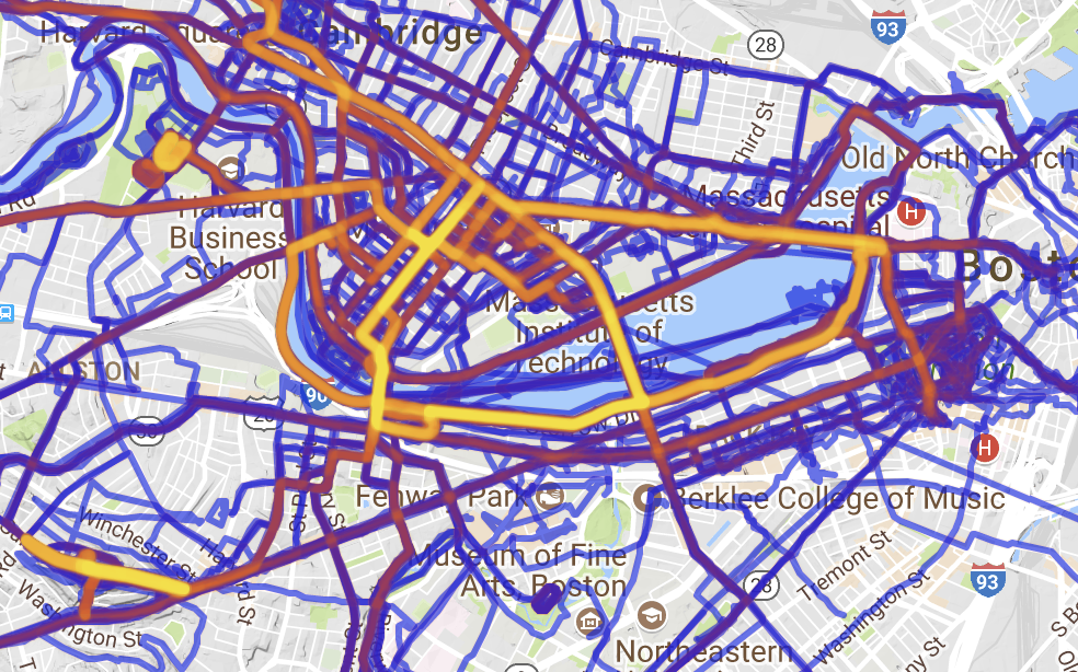
Personal Strava heat map via here.

While it may not be news to many regular readers, in addition to riding bikes and transit advocacy, I dabble in running. Living in Cambridge, one of my regular routes is along the Charles River. According to Strava, I’ve run the section between the BU footbridge and the Harvard Bridge 132 times although this is certainly an under-count due to both GPS issues as well as times when I didn’t run Strava (contrary to public belief, if it isn’t on Strava it is still possible that it did happen). Long story, short: I run along Storrow Drive a lot.

And I’ve noticed something as I navigate the narrow section of path above the buried Muddy River: the lane allocation westbound in the area of the Bowker Overpass is not optimal. As a narrative, proceeding west from Mass Ave:

  • 3 lanes passing under the Harvard Bridge
  • These split in to two 2-lane “barrels”, one feeds Kenmore/Fenway, immediately splitting in to two lanes on to the Bowker Overpass and one to Beacon St, the other feeds two lanes west along Storrow Drive.
  • This second barrel is then met by the flyover from the Bowker Overpass, which is, in turn, fed by two lanes from the Bowker and one lane from Beacon St.
  • This ramp merges down to one lane, and then merges in to the Storrow Drive mainline, with a very short merge area (the signs, in fact, say “no merge area”) with poor sight lines as the merge is on the concave inside of a curve.
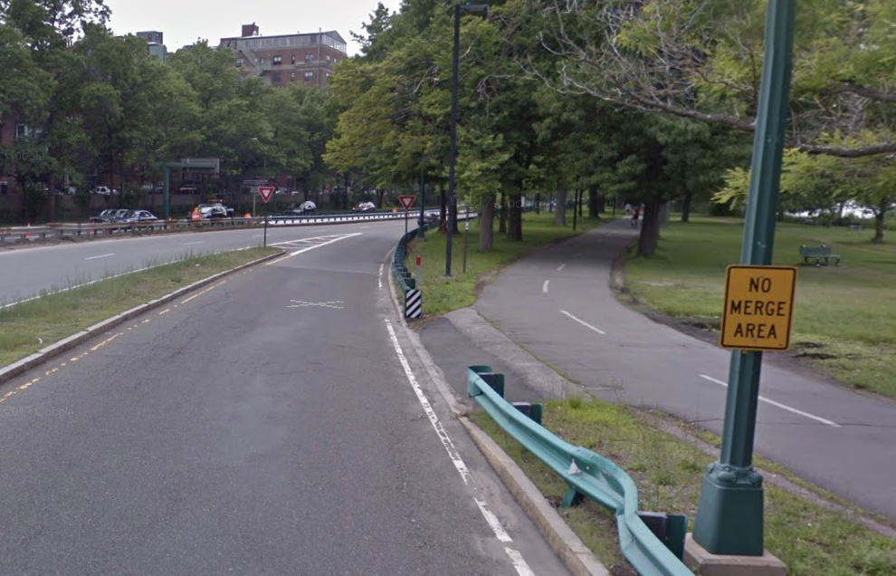
No Merge Area = No good.

It is this last section which is worst. If you attempt to enter Storrow Drive from Beacon Street, you have to merge in to:

  1. the two-lane Bowker ramp
  2. then merge from two lanes to one on the Bowker Ramp and 
  3. then merge on to Storrow Drive

all within a span of 900 feet. The final merge is on to Storrow Drive with poor sight lines, high traffic speed, and no merge area. None of this is good. If these ramps were rationalized, however, these three merges could be replaced by a single merge, including the worst bottleneck at the entrance from Charlesgate to Storrow Drive, going from a dangerous merge to a continuous stream of travel. The state did this circa 2009 (you can see it on HistoricAerials here) but apparently didn’t change enough of the signage, which caused confusion further back, and some people complained, and rather than trying to make it work, they gave up. Old habits die hard. But we should make an effort to change them, rather than revert back to dangerous, inefficient roadways. The road was restriped to its current condition in 2011. There’s no word from the Universal Hubbian masses that it got appreciably better then: people probably got used to it, but it was too late.

This time, let’s not give up. Let’s get some data. Mine is anecdotal and circumstantial: anecdotal because when I observe the area there always seem to be more drivers exiting Storrow Drive to Charlesgate than continuing west and circumstantial because proceeding west on Storrow, the next exit point is at River Street, so there is relatively little reason to get on Storrow rather than to take the Turnpike (except, perhaps, to avoid a toll). So rather than splitting in to four, the three lanes under the Harvard Bridge could feed in to three separate lanes going to Fenway via Charlesgate, Beacon St and west on Storrow. The ramp from Charlesgate would then maintain a single lane on to the overpass, which would eliminate a further merge. So we need these data.

Now, here’s some real data. In the morning peak hour, 3400 vehicles per hour approach the ramp to Charlesgate. 2100 take the ramp, 1300 stay on Storrow, and 800 enter Storrow from Charlesgate. In the evening, 2000 take the ramp, and 2250 stay on Storrow, then joined by 1300 from Charlesgate. So the pinchpoint may be whether a single lane is able to handle 2250 vehicles; a quick spot count on a Thursday night in December showed about 2000 vehicles per hour during this peak time. This may well be a tight fit. But there are certainly single-lane ramps that handle more traffic (the ramp from 95 north to 128 north, for example). By observing the traffic flow, it is apparent that when Charlesgate backs up (not infrequent on normal days, to say nothing of evenings with Red Sox games), the left two lanes become de facto off-ramp lanes, with only the right lane open for through traffic. Codifying this would make the system safer and more efficient.

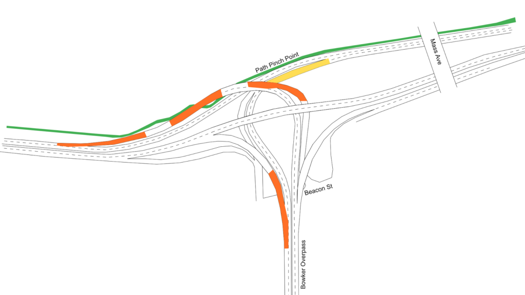
Here is the layout of the current ramps at Charlesgate, with orange areas showing the current merges, and yellow areas showing “sorting” areas where drivers have to choose the required lane. The proposal would simplify this, since each lane would lead to a specific destination, and signage could be improved. (This sign not only doesn’t accurately represent reality—the two right lanes both lead to Newton and Arlington—but it’s far too late for an errant driver to safely correct course. The next sign back has the same images, but slightly different, if somewhat more correct, information. Let’s ignore for a moment the tiny, white-on-blue destination sign no one could reasonably expect to read at 40 mph. If changed, the signs on the Harvard Bridge could read

 Fenway    Kenmore Sq    Newton/Arlington 

above each lane.)

Here is the proposal:

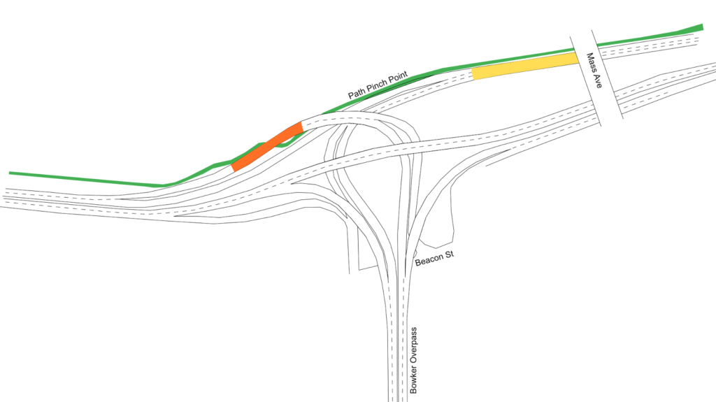
Note that three of the four major merges in Storrow-Charlesgate complex disappear. Just by repainting lines on the road (and likely some physical chicanes to keep Boston Drivers from creating two lanes where they shouldn’t) we can decrease the number of merges by 75%. The one merge left occurs on the longest, straightest portion of the entire complex, and on low-speed ramps, with about 500 feet to merge: three times longer than the merge area when the ramp enters Storrow Drive. And other than signage and paint, there would be no infrastructure costs associated with this sort of project.

Why would a transit-bike advocate like me care about cars? Two reasons. First of all, system efficiency. This is a clear example of where some minor changes could be implemented to create a safer system with less friction, less idling, and less pollution. But the second is that this could be used to improve conditions for bicyclists and pedestrians. Why? Because maintaining the two lanes of Storrow Drive require a pinch point on the Paul Dudley White Path where it narrows from a width of 10 to 12 feet down to 8. If this portion of Storrow were narrowed to a single lane, it would provide plenty of room to widen the bike path and provide a better experience here for cyclists and pedestrians.

Should this be the end state of these ramps? Certainly not. Once the Longfellow is completed, the accident-waiting-to-happen ramp from Storrow to Mass Ave will be rendered redundant and should be closed to eliminate the crossing of the busy sidewalk and bike lane there. In the medium term, Peter Furth makes a strong case that surface roadways could probably handle the traffic, which would be cheaper to build and maintain (the current bridge structures date to the 1960s and are functionally obsolete). In the long run, Storrow Drive and the Charlesgate complex act as mainly as a last-mile distributor from the suburbs to urban job centers. The roads are “necessary” because we don’t have a functional transit system to allow easy travel between the north and south sides of the city (especially between the northern portion of Boston and the Longwood Medical Area complex). With a regional rail connection coupled with congestion-based road pricing (other than political obstinacy, there’s little to keep the DCR from erecting EZ-Pass gantries and tolling the roadway, and the DCR could certainly use the money) we could return the riverbanks to something closer to James and Helen Storrow’s vision. It’s not much, but improving these lanes, at least, would be a start.

MassDOT’s reasoning for closing Riverbend Park is a farce

If you’re going to close a park for a highway project, you better have a damn good reason for it. MassDOT’s reasoning for closing Riverbend Park this summer in Cambridge doesn’t even come close.

Here is a letter John Hawkinson obtained which MassDOT sent to the DCR asking them to keep Memorial Drive open in Cambridge for two Sundays. This letter was never made public, and at no time has MassDOT’s public traffic management plans stated that Riverbend Park would be closed. The letter does not clearly cite a threat to public safety as would be required by state law. In addition, it does not even mention any mitigation for the temporary removal of parkland to satisfy federal 4(f) regulations. None of this has been this mentioned in any MassDOT traffic management plan: the idea was to keep it quiet until the last minute.

This is unacceptable.

The letter does not remove any doubt that there was no thought given to this by MassDOT, just a reaction that more roads are always the solution. This is wrong. The third paragraph of the letter gives the rationale for requesting the removal of this park. The reasons given are:

“The approved traffic management plan requires the use of Memorial Drive as a detour route for both automobiles and MBTA buses throughout the duration of the shutdown.”

However, none of the portion of Memorial Drive used for the detour is affected by the Riverbend Park closures on Sunday. I’ve taken the liberty of adding big red arrows showing the southern extent of the Riverbend Park closure overlaid on MassDOT’s traffic management plan:

Anyone see the problem here? I sure don’t. It seems that all of the detours take place away from the area which is closed on Sundays. The only portion possibly affected would be one half of the BU Bridge southbound detour, except that is adjacent to the portion of Memorial Drive closed. The Riverbend Park closure would actually improve conditions for this portion of the detour, since cars making a left from Memorial Drive to Western Avenue would have the entire green cycle to make the turn, from both lanes, since there would be no oncoming traffic.

Yet there have been no traffic studies or traffic counts.

The “rationale” continues:

“It is important that Memorial Drive remains open to all vehicular traffic during the above requested dates to ensure the smooth, orderly and safe routing of traffic around the limits of the project.”

It is true that we need to have safe, orderly traffic! But Riverbend Park does not affect the portions of Memorial Drive affected by any traffic detour. In fact, by closing Memorial Drive, some drivers may choose to avoid the area altogether, reducing traffic in the project area and reducing congestion.

There is simply no explanation for MassDOT requesting that DCR keep Memorial Drive open, and Riverbend Park closed, during the Commonwealth Avenue Bridge project. With more construction upcoming in the area, we need to make sure that MassDOT has a very high standard for any adverse impacts to parkland. In this case, they have failed to meet such a standard.

Call your Representatives, call your Senators, and demand that Riverbend Park remain OPEN.

Update: I received a response to a call placed to MassDOT. The general process, which apparently happened behind closed doors, was as follows: someone from the “public safety” community asked that the road remain open. MassDOT, without any data or modeling (I asked if any existed and was told that it did not), decided that it was, in fact, a public safety issue, and requested that the DCR keep the roadway open. There was no public process, and the letter only cites the “smooth, orderly and safe routing of traffic,” saying nothing about emergency vehicles.

It turns out, reading the letter closely, MassDOT doesn’t even know where the park is. They request a suspension of “the ban of the use of motor vehicles on Memorial Drive between Western Avenue and Mount Auburn Street.” Yet Riverbend Park extends between Western Avenue and Gerry’s Landing Road; it runs parallel to but never intersects Mount Auburn Street. This is a small oversight, but shows how little mind was actually paid to this issue.

The staffer I spoke with mentioned that it would impact emergency vehicle access to Mount Auburn Hospital (which is not accessed from Memorial Drive) and to the LMA. If there were traffic, then emergency vehicles could use Memorial Drive by moving barricades (this could be staffed by state police traffic details) and then use the BU Bridge, which will be open to buses and emergency vehicles. But that wasn’t brought forth as an option, there was no process involved, and instead the “close the park” was put forward as a solution, one still looking for a problem.

Call to Action: Protect Riverbend Park from DCR Overreach

Since 1975, Memorial Drive in Cambridge has been closed to cars every Sunday from 11 a.m. to 7 p.m., transforming in to Riverbend Park. Originally the idea of a neighbor in Cambridge Isabella Halsted, it is one of the oldest such continual “open streets” events in the country, and it is enjoyed by thousands of residents from across the Commonwealth every week, who can have eight quiet hours to walk along the river without the constant din of automobile traffic.

Except the DCR doesn’t seem to like it. Columnists have noted in the past that they often let cars on to the road before the closure officially ends. The city has requested that the closings continue year-round, but to no avail. DCR is required to close the roadway to traffic by statute passed in 1985, but they do the bare minimum.

There is a condition in that statute, which is that:

the [DCR] may at its discretion suspend
any authorized closings, if in the judgement of said commission such
authorized closing poses a threat to public safety and should any
emergency arise in which said commission in its judgement deems it
necessary to alter the authorized closure.

This is sensible. If there were, for example, a fire along the roadway which required response, or if Soldiers Field Road was closed for repairs, we’d want the DCR to have the authority to open it to traffic. But this summer, the DCR is taking a different tack. With the closure of some lanes of the Turnpike for a construction project, MassDOT is worried that there might be some traffic in the area. They asked DCR to suspend the closure. Traffic is not a threat to public safety—if it were, Boston would be unsafe every day from 6 a.m. to 7 p.m. (longer if the Sox are in town)—but the DCR rolled over and said “sure, we’ll close it, what do we care?”

They may not care, but we do. DCR may not realize it, but this is important to many residents of Cambridge, Boston and the Commonwealth as a whole. They need to hear from us, and from our legislators. If you use Riverbend Park on Sundays—if you’ve taught your kid to ride a bike there, or walked along the river there, or ridden a Hubway there, or drawn in chalk there, or simply enjoyed the quiet along the riverbank there—it’s time to take action. Here’s how:

  1. Contact your legislator. If you don’t already know your Senator and Representative, you can find your legislator here. (Here are maps of districts, you can find a zoomed-in map of House districts here and Senate districts here). Remember to contact your own representatives first. They represent you.Here is a sample letter to write; feel free to customize it and remember to be polite, concise and specific.

    Dear Sen ___ and Rep ___,

    You may have seen a recent Globe article that the DCR plans to close Riverbend Park in Cambridge for two weekends this summer.

    This is unacceptable. Statute stipulates that DCR may only authorize such a suspension of the park if there is a “threat to public safety”. It is hard to fathom how a construction project on a separate roadway in Boston constitutes such a threat.

    Riverbend Park has been a part of Cambridge for 40 years, and I visit the park with my family every weekend to experience the riverbank without the constant drone of nearby traffic. I do not support this suspension. I would ask that you reach out to DCR and demand that they rescind this suspension immediately.

    Thank you,

    Your name
    Your address
    Your telephone/email

    Ask specifically that they follow up with you and let you know what they have found.

  2. Contact the DCR. Your state tax dollars pay for the DCR’s work. Let them know you’re unhappy. The contact for these announcements is Mark Steffen, and his email is Mark.A.Steffen@state.ma.us. Better yet, give him a call: 617-360-1715. His phone should be ringing off the hook. Contact the DCR in general as well, and remember, be firm but polite. If the DCR feels that the public is behind them, they may be more willing to change their minds. Remember, phone calls are better than emails, but both are good.
  3. Contact MassDOT. They are the ones who have made this unreasonable request in the first place. According to the project page, the best contact is James Kersten at 857-368-9041. His phone shouldn’t stop ringing on Monday, either.
  4. Contact the Governor. Again, calling is better than email. Don’t take too much of their time, but make sure to explain yourself and your position. The DCR works for the Governor. If they hear from enough of us, they might be able to make a call to turn this around. Here’s their number: 617.725.4005.
  5. If you live in Cambridge, contact the city council. You can email all of your councilors at council@cambridgema.gov. Note that the council has already asked that Riverbend Park be extended year-round, so they’re on our side, but it’s good for them to hear from their constituents about it. You can also contact the city manager to ask that he take action as well: 617-349-4300.
Obviously, wait until Monday to call. Get a message? Call again. The squeaky wheel gets the grease. It’s time to be squeaky.

Is this small potatoes compared with abhorrent policy on the federal level? Yes. But in Massachusetts, we don’t have much say beyond calling our legislators and asking they fight the good fight. As Cambridge’s own Tip O’Neill often said: all politics is local. Your voice matters. Your voice can be heard.

Who should pay to plow DCR paths? How about the DCR?

Once again, Twitter has reminded us about the inequities of transportation funding: for the severalth year in a row, New Balance is paying to plow the Charles River esplanade paths along the river in Boston. While there’s nothing wrong with this per se—and it may be marketing New Balance is happy to pay for—it shows where our priorities lie. The DCR—which stands for Department of Conservation and Recreation, if you’ve forgotten—has no problem finding the money to plow the roadways which provide transportation along the Esplanade. But when it comes to the pedestrian and cycling paths, they cry poor and make someone else come up with the money.

This is similar to the reaction over the rebuilding of Greenough Boulevard along the river. Everyone was over the moon that the Solomon Foundation had come up with the money to repurpose the roadway from four lanes to two, and to fix an entirely substandard portion of the path there. Yet no one bothered to ask: why do we need a private foundation to fund work the DCR should be doing anyway? The DCR didn’t get a foundation to pay for the guardrail replacement along Storrow Drive, nor did they go looking for a handout from Ford, GM or Toyota. There was a safety issue, and they paid to fix it. They’re happy to do that for roadways, but cry poor when it comes to paying for non-motorized use.

This page has also pointed out that the DCR could recoup hundreds of thousands of dollars a year by monetizing the parking along Memorial Drive near Kendall Square, yet this resource sits fallow. Perhaps next year we could take some of this money to clear the sidewalks, and New Balance could make a donation instead to buy running shoes for students in Boston Public Schools. That would be a more appropriate use of their funds.

Otherwise, I’ll be heartened when I see a Tweet that the DCR announces that, thanks to donations from Ford Motor Company, they’ll be clearing snow off of Storrow and Memorial Drives during the winter, rather than just closing them down whenever snow falls. I expect I’ll be waiting a while for that.

Free Parking? Good in Monopoly. Bad on Memorial Drive

Cost to park: $0.

If you want to go to a Massachusetts State Park, you generally have to pay a parking fee. For $5 or $8 or more you have the privilege of parking on DCR-owned land. If you want to go to Kendall Square—where the going rate for parking is $25 to $30 per day—the DCR has a great deal for you! You can park in one of the 130-or-so parking spaces along Memorial Drive (and another 70 along Cambridge Parkway in East Cambridge) for free!

Does this make any sense?

Everywhere else in Cambridge is either metered parking or resident permit parking (and, yes, resident permits should cost more). The only free spaces in town are on DCR roadways: these spaces, and a few more along Memorial Drive up near Mount Auburn Hospital. The DCR is sitting on a bit of a gold mine: installing meters and charging for parking could bring in close to a million dollars per year.

Let’s imagine that the DCR decided to charge market rate for parking in the area: $2 per hour with a maximum of $20 per day. The cost to install a dozen-or-so parking kiosks would probably run in to the range of $100,000. Enforcement would likely pay for itself with parking tickets. The revenue? Assuming an average of $20 per day on weekdays (through casual parking or charging a daily rate) for the 200 spaces would raise $4,000 per day. With 250 work days in a year (give or take) it adds up to one million dollars. (Even if it was charged at a $1 per hour rate commensurate with the too-low rate for meters along Mass Ave and Vassar Streets, it would bring in $500,000 per year.)

There would be benefits for users, too. Right now, MIT has precious little short-term visitor parking on campus other than a lot on the corner of Vassar and Mass Ave (Rates: $8 per hour, $26 daily). By properly pricing spaces on Memorial Drive, it would give the area a source of open short-term parking, not long term car storage where finding a spot during the day is all but impossible. It would also help to reduce the demand for parking along the adjacent portion of Mass Ave, which could be reused as room for transit lanes and protected bicycle facilities.

And the money? It could be earmarked for non-road projects in the area. The DCR often cries poor when it comes to building sufficient bicycle and pedestrian facilities, but they’re all too happy to keep the roads in ship shape for cars. (There are too many examples including: 1. they refused to rebuild Greenough Boulevard until a private organization coughed up nearly half of the $1.2 million cost. 2. They get New Balance to sponsor the snow clearance of the bike paths along the Charles, yet they don’t hold drivers hostage until Ford and GM pony up to plow Storrow Drive.) A million dollars a year could keep the paths clear of snow, and pay for sorely-needed upgrades. They have a master plan for the Charles River basin but haven’t identified a source of funding. Uh, guys …

This is such a no-brainer that it’s almost criminally negligent that the DCR hasn’t been cashing in on parking fees on Memorial Drive for years. This could be implemented tomorrow (although the historical society would probably throw up a frivolous objection) and the money would start coming in immediately. The DCR has done a fine job rebuild the paths between the BU and Longfellow bridges. There are plenty more sections of the bike paths which could be improved.

What’s wrong with this picture?

A simple question: What is wrong with this picture?

The answer: the cars have a green light to go straight, but the pedestrians have to wait. This signal is optimized for vehicle movement, at the expense of the safety and convenience of pedestrians. Considering that this is an area with high pedestrian use—at the northern end of the BU Bridge along the Paul Dudley White bike path—it is nonsensical that such priority is given to vehicles rather than pedestrians. The only way to get a “walk” light is to push the “beg button” on either side of the crosswalk—otherwise the light stays at “don’t walk” encouraging drivers to make the turn without looking for pedestrians.

But it’s worse. Look to the right. There’s a second traffic light showing green. Cars driving a downgrade are encouraged to make the turn as fast as possible (the tapered corner doesn’t help), at the expense of the pedestrians. Want to cross? Wait until a red light. Although it’s not like that will even help that much: cars can still take a right on red (after “stopping”).

What could be changed to make this intersection safer?

  1. The once-you’ve-turned light should be removed or relocated. Right now it is too far around the curve. By the time a driver sees it in its green phase, they are already crossing the crosswalk. In its red phase, a driver who had missed the main signal would have already crossed the crosswalk. It could be replaced with a “yield to pedestrians in crosswalk” sign.
  2. The walk signal should be changed to display a “walk” sign with every green phase of the light. This will allow for safer pedestrian movement and will not relegate pedestrians to play second fiddle to automobiles at this intersection. It could be enhanced with conspicuous “yield to pedestrians in crosswalk” signage.
  3. At slightly more cost (the first two items would simply require reprogramming or removing the lights) the curb should be bumped out to create more of a right turn movement. This will require vehicles to slow down as they make the turn to cross the crosswalk, which will allow them to better look for pedestrians crossing from one side of the roadway to the other.

This is traffic calming at its simplest: traffic throughput will not likely be curtailed (the bottlenecks in this intersection are not due to this light, but are at other locations) and it would significantly enhance conditions for more vulnerable road users.

A response to the DCR anti-bike statement

Recently, UniversalHub posted an exchange with the DCR regarding winter bicycling maintenance. I’ve seen this as an issue before, but the derision with which the DCR views cyclists is repugnant. I’ve been stewing about this all morning and have posted a line-by-line rebuttal to the last directive which really makes my blood boil. Not only is it derisive and dismissive, but it shows how little the DCR cares about anything that doesn’t have four wheels and an internal combustion engine. I am going to go through it sentence by sentence and provide notes, in italics:

We should all be stating as a policy that DCR has no responsibility or intent of providing “safe” winter biking opportunities on any of our linear paths or sidewalks. 

Since when is this the DCR policy. Is there anything in state statute that directs them not to maintain safe winter conditions on their linear paths or sidewalks? Or is this an internal policy decision.

This is impossible! 

Simply not true. There are several examples of paths which are plowed and maintained in Boston. These include the Minuteman Bikeway, which is maintained by the towns it passes through and well-used. The Somerville Community Path is similar. MassDOT should be applauded for their efforts to keep the Longfellow clear of snow; they have done a stellar job and shown that it certainly is possible to provide a clear path for non-auto users. Additionally, if you look at cities like Madison, Saint Paul and Minneapolis, they have no issue keeping paths trails for cycling. It’s been above freezing in Minneapolis 8 days since December 4. So don’t give me the “it’s too cold in Boston.” It’s been below 0˚ 42 days in that time frame. Spare me.

Any path or walk where we do snow removal is strictly to provide reasonable continued passage for pedestrians.

Why is the level of maintenance between these paths and the parallel roadways different? The roadways are pleasure roadways, yet they are maintained to the same level as any other roadway. If the DCR ran a single plow after the storm and let drivers fend for themselves, I’d understand them not clearing the pathways. However, that is not the case.

If anyone wants to bike our paths in winter they should assume variable and dangerous conditions, and know they are doing it at there own risk.

Then why call them bike paths? The Paul Dudley White Bike Path is called a bike path because it is a bike path. The Soouthwest Corridor is explicitly signed for bicyclists. We understand that paths might not be free of ice and snow, much like we understand that roadways may have patches of ice and snow on them. However, we expect that when we pay tax dollars these go towards maintaining the pathways—putting some effort in to it. It is clear the DCR does not feel that this is the case.

Frankly, I am tired of our dedicated team wasting valuable time addressing the less than .05% of all cyclists who choose to bike after a snow/ice event. 

Wow. Where to begin. First of all, the DCR is spending a lot of time defending not doing any work. How about spending some of this energy going out and actually clearing off the snow from their properties. Then they wouldn’t have to waste this valuable time. Second, 0.05% of cyclists choose to bike after a snow/ice event? This is ridiculous. It’s possible someone here doesn’t understand math and meant 5% (0.05 is 5%, but 0.05% is 0.0005). They are saying that one in 2000 cyclists bikes after a snow event. I was out cycling this past week and rode with a group of five bicyclists on Main Street in Cambridge. By this calculation, there would be 10,000 cyclists on Main Street on a given morning. I can tell you that is not the case. This is dismissive and wrong. 

Sometimes during winter in Boston you can safely bike, and I do it when it is dry and safe. 

False equivalence. Do we say “sometimes you can drive in Boston, when it is dry and safe?” And just because you don’t does that mean that no one should?

This is not one of those winters! 

Please go out and stand on a street corner in Boston and see if there are any safe cyclists. I can attest that there are many.

We should not spend time debating cyclists with poor judgement and unrealistic expectations, and stick with [the staffer]’s recommendation that they find other transportation.

Cyclists who want to be able to bike in the winter have poor judgement? Do drivers who drive in the winter have poor judgement? And is it really unreasonable to expect that bike paths designated as such would be maintained for bicyclists? If this staffer believes that this is the case, they are derelict in their duty and should be removed from their position.

If someone is completely depending on a bike for year-round transportation, they are living in the wrong city.

This is repugnant. The state has a goal of reducing SOV travel, but apparently the DCR is not on board. It is time for the DCR to work with the rest of the Commonwealth, not against it. And if Boston is the wrong city to be a cyclist in the winter, perhaps we should move to Minneapolis or Madison, a city with worse winters, but which actually invests in its cyclists.

Design in isolation

There are several recent projects in the Boston/Cambridge area—some of which have been covered on this page—that have been in the conversation recently. One major flaw of all of these is that they do little to combine the features of multiple projects but rather are viewed in isolation, even though they often border each other and, in many cases, deal with the same roads, paths and transitways. These include:

These are all worthy projects, and it’s mildly infuriating that there is no overarching planning agency which can corral these in to one cohesive plan. Right now, it’s an alphabet soup which includes MassDOT, DCR, Cambridge, Boston, the MBTA, Harvard and MIT (they own part of the Grand Junction right of way). The issue is that these projects are often viewed as singular entities, and not in relation to the greater transportation ecosystem. For instance, I see the Allston campus, Cambridge Street Overpass and Turnpike Straightening as inextricably linked, with no small connection to the DCR paths and, down the line, the Bowker overpass. A vehicle driving over the Bowker Overpass may well have come from Harvard Square, via a DCR roadway and through the Turnpike interchange. And, heck, with better transit or bicycling connections, that vehicle might not be there at all. 
Instead of single-item traffic studies, we need to take a holistic view of the transportation infrastructure in the region, and decide what we want to see in 20 or 30 years: slightly realigned roadways which still prioritize funneling as much traffic as possible to the detriment of other uses, or a more complete transportation system. Most of the infrastructure in question is 50 or more years old, and will need to be rebuilt (or reconsidered) in coming years. Instead of rebuilding the broken infrastructure we have, we need to take a broader view of what we could create. Since we’re going to have to spend the money anyway, we might as well spend it wisely now, rather than have to fix yesterday’s problems tomorrow.

This page will attempt to do so in the near future.