Optimizing traffic on Storrow Drive

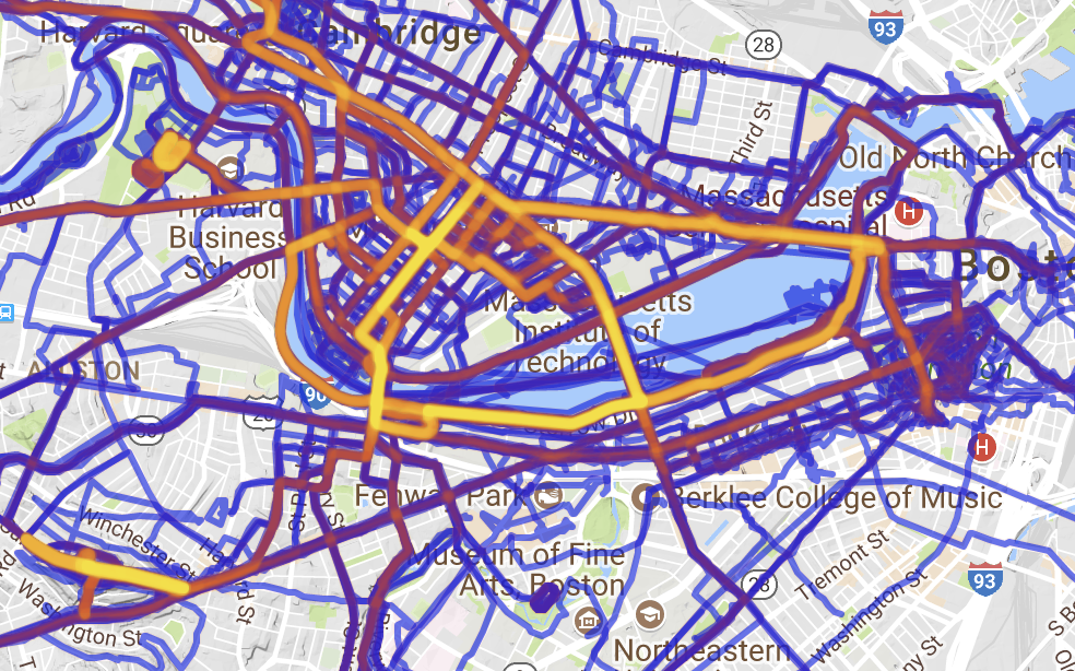
Personal Strava heat map via here.

While it may not be news to many regular readers, in addition to riding bikes and transit advocacy, I dabble in running. Living in Cambridge, one of my regular routes is along the Charles River. According to Strava, I’ve run the section between the BU footbridge and the Harvard Bridge 132 times although this is certainly an under-count due to both GPS issues as well as times when I didn’t run Strava (contrary to public belief, if it isn’t on Strava it is still possible that it did happen). Long story, short: I run along Storrow Drive a lot.

And I’ve noticed something as I navigate the narrow section of path above the buried Muddy River: the lane allocation westbound in the area of the Bowker Overpass is not optimal. As a narrative, proceeding west from Mass Ave:

  • 3 lanes passing under the Harvard Bridge
  • These split in to two 2-lane “barrels”, one feeds Kenmore/Fenway, immediately splitting in to two lanes on to the Bowker Overpass and one to Beacon St, the other feeds two lanes west along Storrow Drive.
  • This second barrel is then met by the flyover from the Bowker Overpass, which is, in turn, fed by two lanes from the Bowker and one lane from Beacon St.
  • This ramp merges down to one lane, and then merges in to the Storrow Drive mainline, with a very short merge area (the signs, in fact, say “no merge area”) with poor sight lines as the merge is on the concave inside of a curve.
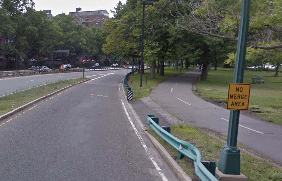
No Merge Area = No good.

It is this last section which is worst. If you attempt to enter Storrow Drive from Beacon Street, you have to merge in to:

  1. the two-lane Bowker ramp
  2. then merge from two lanes to one on the Bowker Ramp and 
  3. then merge on to Storrow Drive

all within a span of 900 feet. The final merge is on to Storrow Drive with poor sight lines, high traffic speed, and no merge area. None of this is good. If these ramps were rationalized, however, these three merges could be replaced by a single merge, including the worst bottleneck at the entrance from Charlesgate to Storrow Drive, going from a dangerous merge to a continuous stream of travel. The state did this circa 2009 (you can see it on HistoricAerials here) but apparently didn’t change enough of the signage, which caused confusion further back, and some people complained, and rather than trying to make it work, they gave up. Old habits die hard. But we should make an effort to change them, rather than revert back to dangerous, inefficient roadways. The road was restriped to its current condition in 2011. There’s no word from the Universal Hubbian masses that it got appreciably better then: people probably got used to it, but it was too late.

This time, let’s not give up. Let’s get some data. Mine is anecdotal and circumstantial: anecdotal because when I observe the area there always seem to be more drivers exiting Storrow Drive to Charlesgate than continuing west and circumstantial because proceeding west on Storrow, the next exit point is at River Street, so there is relatively little reason to get on Storrow rather than to take the Turnpike (except, perhaps, to avoid a toll). So rather than splitting in to four, the three lanes under the Harvard Bridge could feed in to three separate lanes going to Fenway via Charlesgate, Beacon St and west on Storrow. The ramp from Charlesgate would then maintain a single lane on to the overpass, which would eliminate a further merge. So we need these data.

Now, here’s some real data. In the morning peak hour, 3400 vehicles per hour approach the ramp to Charlesgate. 2100 take the ramp, 1300 stay on Storrow, and 800 enter Storrow from Charlesgate. In the evening, 2000 take the ramp, and 2250 stay on Storrow, then joined by 1300 from Charlesgate. So the pinchpoint may be whether a single lane is able to handle 2250 vehicles; a quick spot count on a Thursday night in December showed about 2000 vehicles per hour during this peak time. This may well be a tight fit. But there are certainly single-lane ramps that handle more traffic (the ramp from 95 north to 128 north, for example). By observing the traffic flow, it is apparent that when Charlesgate backs up (not infrequent on normal days, to say nothing of evenings with Red Sox games), the left two lanes become de facto off-ramp lanes, with only the right lane open for through traffic. Codifying this would make the system safer and more efficient.

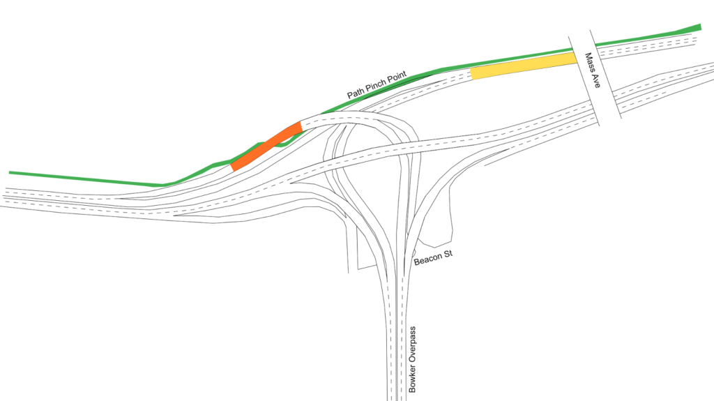
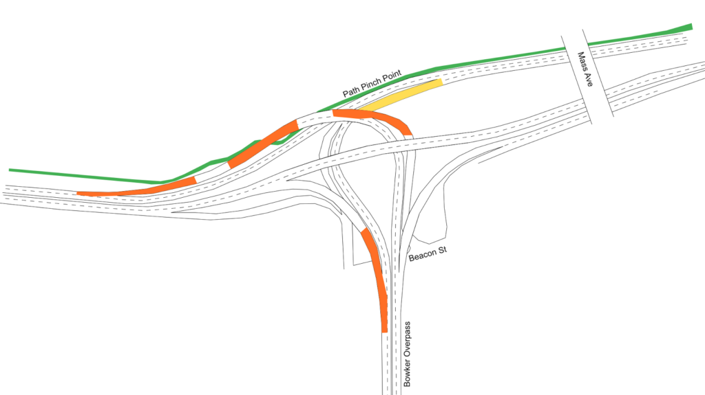
Here is the layout of the current ramps at Charlesgate, with orange areas showing the current merges, and yellow areas showing “sorting” areas where drivers have to choose the required lane. The proposal would simplify this, since each lane would lead to a specific destination, and signage could be improved. (This sign not only doesn’t accurately represent reality—the two right lanes both lead to Newton and Arlington—but it’s far too late for an errant driver to safely correct course. The next sign back has the same images, but slightly different, if somewhat more correct, information. Let’s ignore for a moment the tiny, white-on-blue destination sign no one could reasonably expect to read at 40 mph. If changed, the signs on the Harvard Bridge could read

 Fenway    Kenmore Sq    Newton/Arlington 

above each lane.)

Here is the proposal:

Note that three of the four major merges in Storrow-Charlesgate complex disappear. Just by repainting lines on the road (and likely some physical chicanes to keep Boston Drivers from creating two lanes where they shouldn’t) we can decrease the number of merges by 75%. The one merge left occurs on the longest, straightest portion of the entire complex, and on low-speed ramps, with about 500 feet to merge: three times longer than the merge area when the ramp enters Storrow Drive. And other than signage and paint, there would be no infrastructure costs associated with this sort of project.

Why would a transit-bike advocate like me care about cars? Two reasons. First of all, system efficiency. This is a clear example of where some minor changes could be implemented to create a safer system with less friction, less idling, and less pollution. But the second is that this could be used to improve conditions for bicyclists and pedestrians. Why? Because maintaining the two lanes of Storrow Drive require a pinch point on the Paul Dudley White Path where it narrows from a width of 10 to 12 feet down to 8. If this portion of Storrow were narrowed to a single lane, it would provide plenty of room to widen the bike path and provide a better experience here for cyclists and pedestrians.

Should this be the end state of these ramps? Certainly not. Once the Longfellow is completed, the accident-waiting-to-happen ramp from Storrow to Mass Ave will be rendered redundant and should be closed to eliminate the crossing of the busy sidewalk and bike lane there. In the medium term, Peter Furth makes a strong case that surface roadways could probably handle the traffic, which would be cheaper to build and maintain (the current bridge structures date to the 1960s and are functionally obsolete). In the long run, Storrow Drive and the Charlesgate complex act as mainly as a last-mile distributor from the suburbs to urban job centers. The roads are “necessary” because we don’t have a functional transit system to allow easy travel between the north and south sides of the city (especially between the northern portion of Boston and the Longwood Medical Area complex). With a regional rail connection coupled with congestion-based road pricing (other than political obstinacy, there’s little to keep the DCR from erecting EZ-Pass gantries and tolling the roadway, and the DCR could certainly use the money) we could return the riverbanks to something closer to James and Helen Storrow’s vision. It’s not much, but improving these lanes, at least, would be a start.

Who should pay to plow DCR paths? How about the DCR?

Once again, Twitter has reminded us about the inequities of transportation funding: for the severalth year in a row, New Balance is paying to plow the Charles River esplanade paths along the river in Boston. While there’s nothing wrong with this per se—and it may be marketing New Balance is happy to pay for—it shows where our priorities lie. The DCR—which stands for Department of Conservation and Recreation, if you’ve forgotten—has no problem finding the money to plow the roadways which provide transportation along the Esplanade. But when it comes to the pedestrian and cycling paths, they cry poor and make someone else come up with the money.

This is similar to the reaction over the rebuilding of Greenough Boulevard along the river. Everyone was over the moon that the Solomon Foundation had come up with the money to repurpose the roadway from four lanes to two, and to fix an entirely substandard portion of the path there. Yet no one bothered to ask: why do we need a private foundation to fund work the DCR should be doing anyway? The DCR didn’t get a foundation to pay for the guardrail replacement along Storrow Drive, nor did they go looking for a handout from Ford, GM or Toyota. There was a safety issue, and they paid to fix it. They’re happy to do that for roadways, but cry poor when it comes to paying for non-motorized use.

This page has also pointed out that the DCR could recoup hundreds of thousands of dollars a year by monetizing the parking along Memorial Drive near Kendall Square, yet this resource sits fallow. Perhaps next year we could take some of this money to clear the sidewalks, and New Balance could make a donation instead to buy running shoes for students in Boston Public Schools. That would be a more appropriate use of their funds.

Otherwise, I’ll be heartened when I see a Tweet that the DCR announces that, thanks to donations from Ford Motor Company, they’ll be clearing snow off of Storrow and Memorial Drives during the winter, rather than just closing them down whenever snow falls. I expect I’ll be waiting a while for that.

Allston-Brighton toll straightening shouldn’t ignore Soldiers Field Road

Massachusetts has taken on a surprisingly progressive role in transportation policy in recent years, with the transportation secretary publicly stating that “we will build no more superhighways” and setting explicit goals for a shift away from single-occupancy driving. As part of this fix-what-we-have policy, the state is planning to convert the whole of the antiquated tolling system to open-road tolling, eliminating toll boots and charging vehicles based on transponders and license plates. This is a good step forward as it will not only reduce congestion at toll booths but also reduce the amount of land required by the serpentine ramps and plazas needing at Turnpike entrances and exits. While rural interchanges won’t be changed, it give the opportunity to rework a lot of urban land previously occupied by redundant roadways.

Nowhere is this more of an issue than at the Allston tolls in Boston. Here, the main trunk of the Turnpike loops around a now-disused rail yard, and a convoluted set of ramps feed on and off of it with four separate toll plazas. The state has announced a $260 million plan to straighten this interchange, which contains dozens of bridge spans in need of replacement. An early conceptual design has been announced that reduces the amount of land required and simplifies the roadways. While this is a good start, it ignores the space just beyond the interchange, namely, the confusing and dangerous interchange with Soldiers Field Road which is congested, a major impediment to bicyclists and pedestrians and which darkens a stretch of the Charles River with highway ramps and traffic jams.
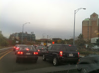
Typical traffic.

The Turnpike-Cambridge/River Street-Soldiers Field-Western Avenue interchange is a royal mess. It is so confusing that the state long ago stopped maintaining lane markings, and today it is a free-for-all as vehicles jockey for position as ramps funnel in to each other at a series of lights. For bicyclists and pedestrians? It’s a nightmare. Coming east on Cambridge Street is nearly impossible through the traffic chaos, and even crossing Western Avenue and Cambridge/River Street on the Paul Dudley White Bike Path is difficult, without a specific bike/ped cycle, crosswalks, curb cuts or even, at the southern bridge, a walk light!

A bit of a radical idea here that I’m proposing would be to move Soldiers Field Road away from the River. From Boston to Watertown, nearly the entirety of the Charles River is lined by highways. Yes, there is a bike path squeezed in between the riverbank and the roadway, but it is clear that cars are given the priority—we’ve turned our back on the river. The bike path is narrow, and when it intersects roadways crossing amidst the turning vehicles, it is perilous. It is a poor excuse for bicycle infrastructure, yet it is quite heavily used. Added to this, Soldiers Field Road doesn’t even follow a straight line but hugs the riverbank, adding distance (and pollution) for motor vehicles.

Here, then, is a conceptual plan to both improve the Turnpike interchange and the connection between the Turnpike, Soldiers Field Road, Western Avenue and River Street. Just doing the first part will still result in backups, congestion and pollution, and do nothing to improve the lot of pedestrians or cyclists. This plan would improve conditions for all users, and while it would require a major buy-in from Harvard University (which owns the land Soldiers Field Road would be rerouted across), they would be given a major incentive: an Allston campus connected directly to the river (in fact, some of their long-range plans have included decking over part of Soldiers Field Road). Depressing and covering the road would be simple compared to many similar projects (i.e. the Big Dig) as it runs almost entirely through post-industrial brownfields and athletic fields, no major property takings or utility work would be necessary, and much of the route would be closed to trucks, meaning the road clearance would only have to be big enough for emergency vehicles (and, perhaps, transit buses).

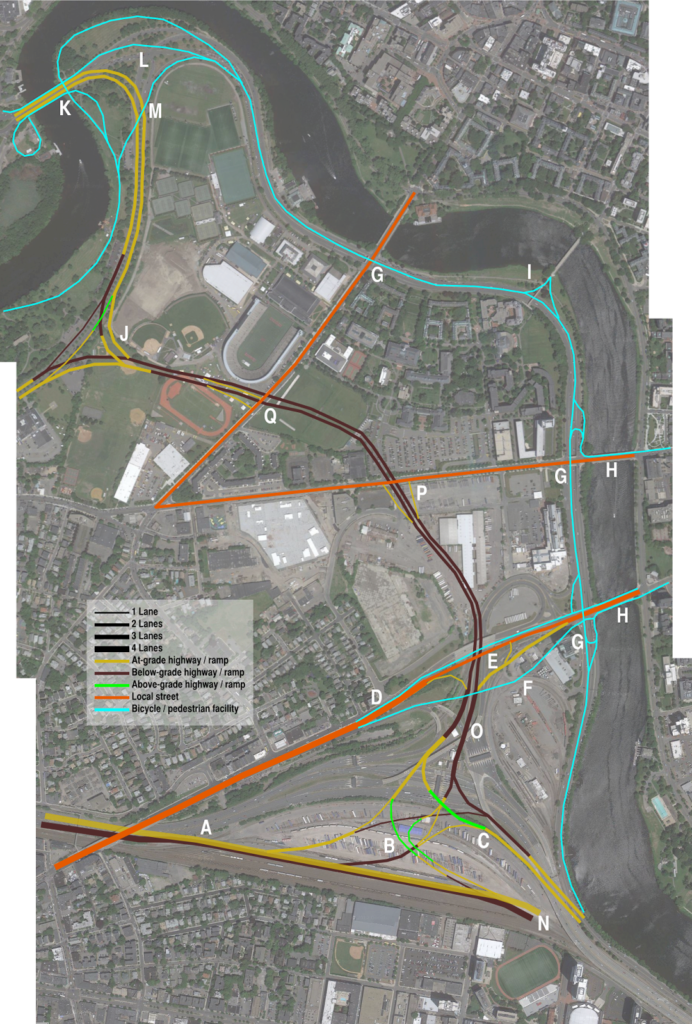
I’ve annotated the map, each letter corresponds to a comment below:

Click to make big!

A: The eastbound Turnpike main trunk would be depressed below the westbound trunk, allowing ramps to overlay.
B: A single westbound ramp would allow access to Soldiers Field Road in both directions, as well as River Street in Cambridge. Western Avenue would be accessed via Soldiers Field Road. Note that if Soldiers Field eastbound were merged with the Turnpike (see below), these ramps would be mostly below-grade; it could be built to allow that sort of conversion at a later time.
C: Soldiers Field east mainline. These roadways, and the ramps on and off of them, would not require truck clearances (but would require clear “no trucks” signage).
D: Cambridge Street could be narrowed to 4 lanes, and narrower yet between ramps. Sidewalks and cycletracks could be elevated to avoid ramp entrances and exits. Traffic from Western Avenue to Cambridge Street via Memorial Drive.
E: Offramp to Cambridge Street would end at a traffic signal.
F: Elevated cycletrack / sidewalk allows cyclists to avoid traffic signal and on/off ramps.
G: River bike path built 12+ feet wide, utilizes one of the disused Soldiers Field underpasses to avoid grade crossings. This would allow a 8-mile traffic-free trip from the Charles River dam west to the Western Avenue Bridge in Brighton by foot or bicycle. The other side of these underpasses would be filled.
H: Separated cycletrack facilites on the Western and River/Cambridge bridges would connected with the grade-separated riverside bike path. The riverside path could be set back from the riverbank, which would be maintained for active and passive recreation.
I: Rebuild the Weeks Bridge with ADA accessibility, and connect to bike paths for a river crossing.
J: The connection between Soldiers Field Road and the Eliot Bridge would be grade-separated; the current connection has a three-phase light in the center. Another option would be a single-point light between the Soldiers Field East-Eliot Bridge and Eliot Bridge-to Soldiers Field East which would reduce grade separation.
K: The current underpasses under the Eliot Bridge for bicyclists and pedestrians would be retained. Sidewalks / paths on the bridge would be used for grade-separated access to south-side pathways.
L: Most of the intersection east of the Eliot Bridge would be rebuilt as a wide swath of parkland.
M: A bicycle bridge would be built across the Eliot Bridge connection, cutting some distance off this route. Grade-separation would be integrated with the Eliot Bridge, and the current Eliot Bridge underpass would be retained (K).
N: Ramps to the current elevated structure would be built not to preclude future grade separation eastbound.
O: Mixing zones on Soldiers Field Road would be three lanes wide, and long enough to allow traffic to merge across two lanes to access various routes (although engineering would be required to determine the optimal length here so as not to bottleneck).
P: Ramps to Western Avenue would be built to specifications for truck traffic; north of this it would be cars-only. Traffic destined to Harvard Square would be routed west on Western and then east on Harvard, or via Memorial Drive.
Q: Ramps at North Harvard Street would be offset to keep construction away from Harvard Stadium. The track would be reoriented after construction.

While adding Soldiers Field Road reconfigurations to the rebuilding of the Turnpike interchange, the project should still not be viewed in isolation but rather as part of the larger transportation network. A few things to consider:

  1. Allowances should be made for future fixed-guideway transit between BU and Harvard.
  2. The entirety of the Turnpike, the railroad tracks and as many ramps as possible could be buried to allow the street grid to be connected across the rail yard from the BU area towards the river.
  3. Instead continuing east along the river, Soldiers Field Road could merge in to the Turnpike. This would require a wider highway (perhaps five lanes in each direction) and require the highway to be rebuilt below-grade to allow for room for the rail line. It would probably also necessitate some sort of exit in the Charlesgate area. This would be moving towards Big Dig territory as far as complexity, although by moving all rail service to North Station via Cambridge on the Grand Junction, enough space could be freed up to phase construction along the Turnpike. It would, however, create a three-mile-long section of riverfront with no roadway between the city and the river. (Paul Levy made this point years ago.)
  4. The Grand Junction, if (3) were built, would have to be fully rebuilt, below grade and with a transfer station at Kendall Square, although this would be a dramatic transit enhancement for the region and worth the investment.
  5. If Soldiers Field Road and Storrow Drive beyond it were replaced, it would recreate the parkland which James and Helen Storrow originally intended along the river. A two-lane parkway-type road could be retained from Charlesgate (which would have the Bowker Overpass flyovers removed) eastward (although this, too, could be in a tunnel) with a wider roadway resuming only past the current tunnel near the Hatch Shell towards Leverett Circle.
In other words, a project as large as proposed for the Allston Tolls should not be viewed in isolation, as its effects—good or bad—will cascade in several directions along the transportation network. With this kind of brownfield, simply rejiggering some onramps—and ignoring nearby bottlenecks and queues—is not enough.