Service, Not Storage

One of the many issues with the Allston project that I have been way too involved with is that the State maintains that they need a midday layover yard for Commuter Rail equipment. Why? Because they plan to add capacity to South Station and, since they can’t stack out-of-service trains in the terminal, need somewhere to store them when they’re not in use in the middle of the day. (Off-topic but relevant: the need for and cost of which could be obviated completely simply by building the North-South Rail Link; thru-running is so much more efficient that in Philadelphia SEPTA runs 44 trains per hour through its four track tunnel at rush hour while the MBTA peaks at 32 trains combined on 22 tracks at North and South stations.)

The relevant issue, however, is how silly it is to build large rail yards on prime real estate in order to not run service!

The supposed “need” for this whole facility could be obviated simply by running more trains in service in the midday. (Some layover space could be built between Cambridge and Everett streets in Allston without impacting transit operations and development of the Beacon Park Yards.) If you have more trains in service, you don’t need storage for them. Considering that 75% of the costs of running Commuter Rail in Massachusetts are fixed, much of the marginal cost of providing increased service would be made up for by the opportunity cost of not building such an unnecessary facility. Most every other major Commuter Rail line runs more frequent midday service than the MBTA, even on lines to major anchor cities like Worcester, Providence and Brockton. In English: you have the trains, and the track, and the stations. Just run more darned trains already!

With that said, you still need to figure out where to run these darned trains. Obviously, increasing service on current lines to large cities and “Gateway Cities” makes sense. But there’s actually a way to increase service to Western Massachusetts without any major investment in track, stations or additional equipment. Right now, several train sets begin and end their day in Worcester. These trains could, instead, begin their trips further west, providing service to Springfield the Pioneer Valley.

The Commonwealth and Feds recently spent $83 million to upgrade the Connecticut River Line for passenger service, and the Boston and Albany main line already hosts Amtrak trains (albeit at a pitiful top speed of 59 mph). So you might as well get some use out of it! There is a vague plan to provide commuter service in the Pioneer Valley soon linking Greenfield, Northampton, Holyoke and Springfield, and connecting with upgraded Springfield-Hartford-New Haven “Knowledge Corridor” service. Service couldn’t start overnight, steps would include working out a track use agreement with CSX and qualifying crews west of Worcester. But the track (with the exception of layover facilities in Greenfield; I assume trains could be stored overnight on tracks in Springfield’s station), stations (with the exception of Palmer where you might want to build a new station) and trains are in place. It’s not a big leap to running service.

Here’s what a schedule would look like for the trips serving Boston, Springfield and Greenfield. Train numbers are shown for current Amtrak or MBTA Commuter Rail service, and use current travel times, although the Boston and Albany ran two-hour Springfield-to-Boston schedules in 1950 with stops in Palmer, Worcester, Framingham and Newtonville. (Amtrak 448/449 is the Lake Shore Limited to and from Chicago via Albany, 55/56 is the Vermonter from Saint Albans to Washington D.C.)

Eastbound
       Train # →          MBTA 508     MBTA 552       NEW       AMTK 56     AMTK 449  
Dep Greenfield 5:45 13:36
Dep Springfield 5:45 6:45 13:00 14:35 17:33
Arr Boston 8:20 9:07 15:20 20:01
Westbound
       Train # →            NEW       AMTK 448     AMTK 55     MBTA 521     MBTA 551  
Dep Boston 9:38 12:50 17:05 19:35
Arr Springfield 12:00 15:18 15:15 19:35 22:00
Arr Greenfield 16:15 23:00

Rightly or not, Western Mass often feels like it gets the short end of the bargain when it comes to transportation funding. There has been hundreds of millions of dollars spent on infrastructure (most notably the Knowledge Corridor and Springfield Union Station), yet very little service to show for it. This mistake would be compounded by overbuilding layover facilities in Boston and siloing operations in Eastern and Western Massachusetts. Any passenger movements would need to accommodate CSX freight traffic between Worcester and Springfield, and in the long term, much more increased service may require a larger investment to re-double track the B&A line to Springfield (and to increase line speed where possible as well).

In any case, rail service in Massachusetts has long been focused on Boston, with a minimal statewide transportation plan (well, beyond taking donations from Peter Pan, buying them buses and having them get stuck in traffic on the Pike). The state has taken hundreds of millions of Federal dollars (and local match) to upgrade the line in the Pioneer Valley, but it barely runs any service. It would be a politically wise move to better serve Western Mass and, given traffic and tolls, would probably attract significant ridership, too.

When Boston Almost Lost Commuter Rail

The 1970s was not a good time for rail commuters in Boston. New roadways had opened and several rail lines shut, and those left had anemic schedules. In the 1950s, Commuter Rail was provided by private carriers (the Boston and Maine north of the city, the Boston and Albany—owned by the New York Central—on the Worcester Line and the New Haven elsewhere from South Station) in a manner similar to today on major lines, with less service on some branch lines (nearly all of which have since been abandoned). Many of these timetables from 1952 can be found here. In the late 1940s, South Station handled 125,000 passengers, far more than today. Only Chicago, Philadelphia and New York had similar or larger systems.

Significant cuts came in the 1950s, including the demise of the Old Colony Lines when the Southeast Expressway opened. After beginning to provide subsidies in the 1960s to commuter railroads, the T was in the midst of a many-years-long experiment to figure out how to best fund Commuter Rail, and service was often cut in towns which refused to pay up, leading to closed-door service where trains would bypass stations in a non-paying municipality. (This coincided with upheaval in the rail industry in general, as Penn Central and Boston and Maine both teetered on the brink of insolvency, while still operating the T’s Commuter Rail system.) Termini were cut back and on the north side outer sections of rail lines often only had a single trip in the morning and evening (or as the T would say today: “twice a day“).

Rail lines, owned by bankrupt freight lines (even the mostly-passenger New Haven had been merged in to the ill-fated Penn Central), fell in to disrepair. Service to South Sudbury was cut in 1971 (49 minutes Sudbury to North Station; try that today), Worcester was dropped in 1975, Bedford (35 minutes to Boston) was mothballed in 1977 and Woburn in 1981. What service remained was often run on a skeleton schedule with only a handful of inbound runs in the morning and outbound in the evening. Ridership and service would better be compared to the ill-fated lines in Pittsburgh, Cleveland and Detroit. No longer was the MBTA in the same league as Metra, SEPTA or the lines serving New York. It was a hair away from disappearing all together.

In the 1980s, however, something changed. The state bought new equipment, rebuilt track and increased the number of trips. By the 1990s, the Southwest Corridor was complete, the Old Colony Lines rebuilt (or, in the case of Kingston, overbuilt), and service reinstated to Worcester, Providence and Newburyport. Lines which saw one train a day in the 1970s (or, at times, zero) had 20, and most weekend service had been reinstated. Ridership responded: while 15,000 passengers boarded trains daily in 1972 (and most of the rest of the decade), by 2000, 60,000 passengers rode the rails each day.

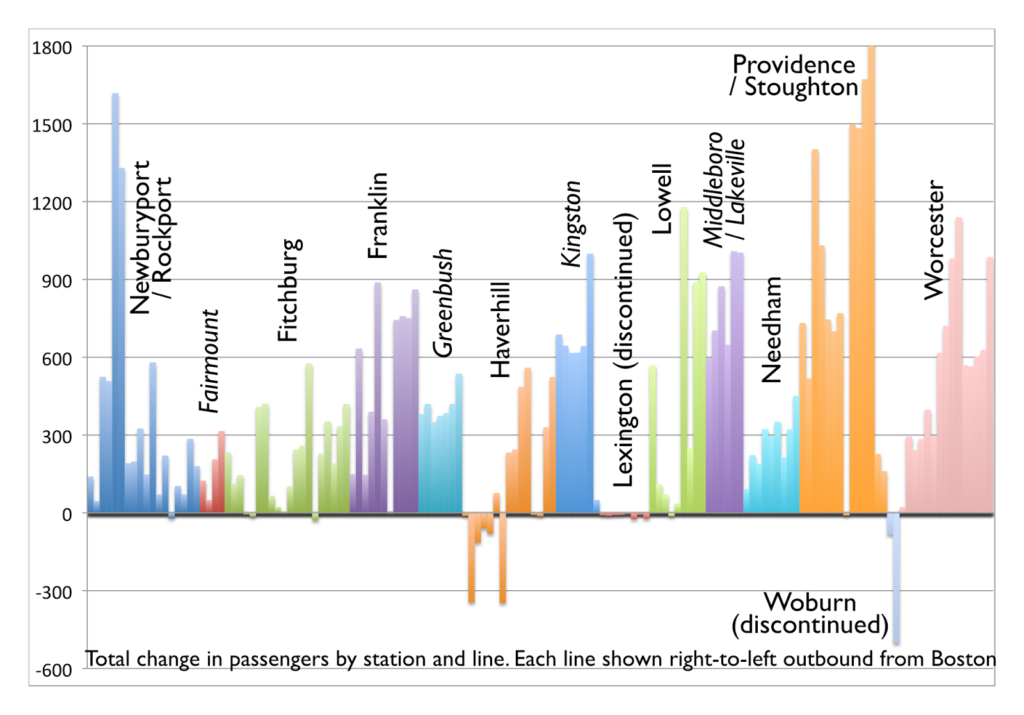
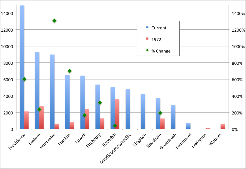
The patterns of this change are interesting. Today (note that current numbers use the median ridership for the past 10 years, based on MBTA Blue Book data to account for variability in passenger counts in single years), about 46,000 passengers use lines radiating from South Station while 26,000 passengers use those from North Station. In 1972, the numbers were much lower, and the ratios reversed: 11,000 passengers used North Station, and fewer than 5,000 used South Station lines. So while North Station has grown significantly in the past 40 years—by 150%—South Station has increased by nearly ten times (1000%). It’s hard to imagine how sleepy South Station must have been in the 1970s, as compared to the constant streams of commuters crowding the concourse today.

Line-by-line, even station-by-station, there are dramatic differences in the changes over the years.

Of the top five lines in 1972, four were on the North Side: Haverhill, Eastern Route (Newburyport/Rockport), Lowell, Attleboro and Fitchburg. Today, three of the top five lines are on the South Side: Providence, Eastern, Worcester, Franklin and Lowell. In 1972, the Worcester Line bested only the two-station Woburn spur and the Lexington/Bedford line, both of which were discontinued in the ensuing decade.

In 1972, the Reading Line—the single Haverhill train operated via the Wildcat Line—accounted for more than 20% of Commuter Rail’s total ridership. I-93 hadn’t yet fully opened to Boston, and the Orange Line ended in Everett rather than Oak Grove. While overall Haverhill ridership has increased, all of the gains have come from the outside of the line; there are fewer passengers at nearly every station from Reading inbound. The Worcester Line, on the other hand, carried just 600 passengers on three rush hour trains. Today it has that many trains per hour at rush hour, each of which carries 600 passengers (or more).

In absolute numbers, the biggest gains have been along the Providence Line and at Salem and Beverly, where several stations have seem gains of more than 1000 riders per day (some of which, like Providence and South Attleboro, had a baseline of zero). Many stations across the system have gained 500 riders a day or more. The inner Haverhill Line and nearby stations on the Woburn Branch stand out as the only stations to lose significant ridership; most other stations showing ridership declines are small stations which were closed (the largest, West Acton, now has a shuttle bus to South Acton, where parking is full before 7 a.m.).

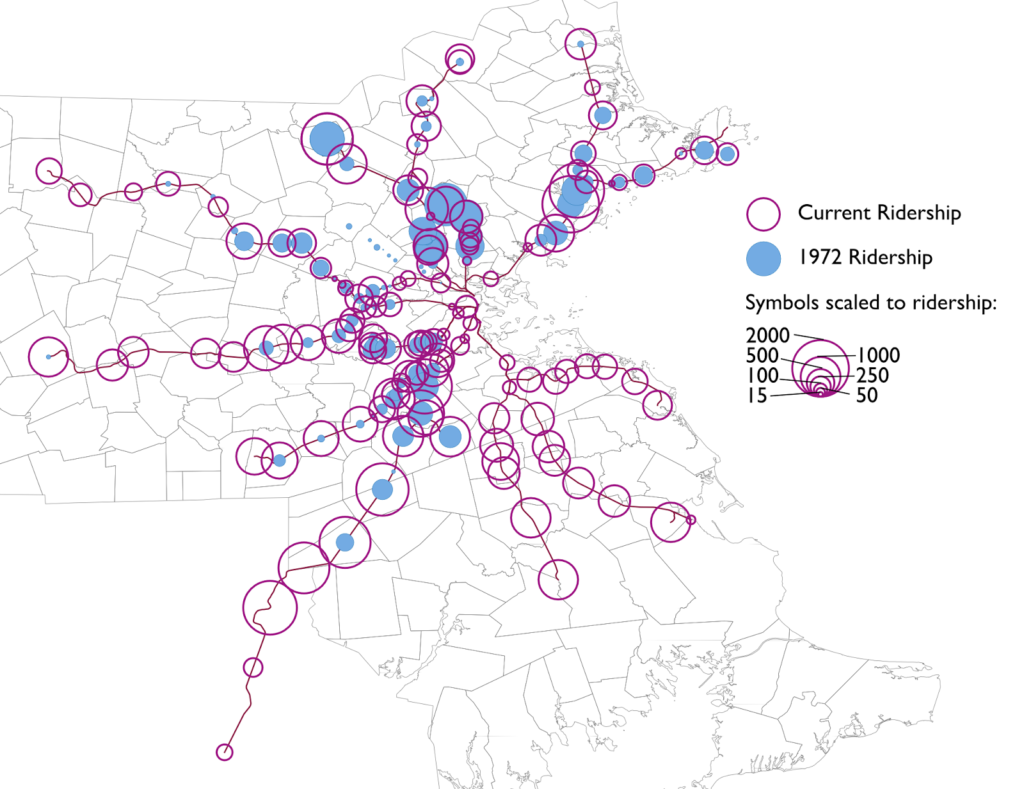
These data can also be mapped, of course. The map shows the disparate growth on different lines, and how minimal ridership was in 1972, especially south and west of the city, compared with today.

Note that 1972 ridership is shown in B&M blue, since the B&M operated the majority of the system then.

Boston came very close to losing its commuter rail system in its entirety, something which occurred in no other city (the closest was the abandonment of the non-electrified portions of the SEPTA system in the early-1980s; while Boston’s ridership began to rise in the 1980s, SEPTA and Metra saw ridership decline in the early ’80s). Had the highway moratorium not come in to place in 1972 and the Southwest Corridor been built as a highway, it may have meant the end of commuter service south of the city. Worcester ridership was minimal, and the T threatened to curtail north side service entirely—the majority of the system at that point—if it couldn’t buy the assets of the Boston and Maine.

Improvements and additions to trackage and rolling stock from the 1970s to 1990s fueled dramatic growth in the system, although it has leveled off in the past decade, a combination of higher fares and an aging physical plant. While the system is no longer on the brink of insolvency—even if it were, adding 60,000 cars to Boston’s already strained road system would be a non-starter—it needs a new round of investment as the city, and especially the downtown core, continues to grow.

A more efficient Alewife-Harvard shuttle could save $30,000 per day

I had the opportunity yesterday to ride the rail-replacement shuttle from Alewife to Harvard. (I’m not faulting the T for such shutdowns at all, maintenance needs to happen.) But the buses are run very inefficiently, and if the route was changed, it could halve the number of buses required to provide the service, cutting the cost of operating these buses by tens of thousands of dollars, and provide better service for most riders.

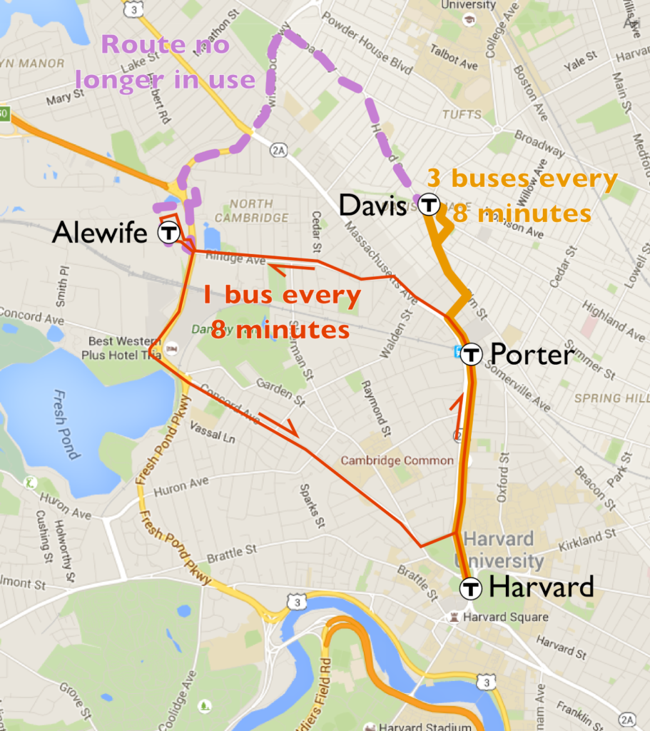
The issue is that while Alewife is a pretty straight shot from Harvard by rail, it isn’t by road. Somerville pushed hard to have Davis included in the Red Line extension in the 1980s, and the subway follows the old Fitchburg Cutoff from Davis to Alewife, less than a mile. But the bus route is longer: it runs out from Davis to Teele Square and Clarendon Hill, then turns on to the narrow-laned Alewife Brook Parkway (going inbound, this is a very tight turn for buses; the bus I was on was forced to drive over the sidewalk to make it) before running through the mess of an intersection at Route 2 and on to Alewife, a distance of more than two miles (with half a dozen traffic lights). And the buses here are mostly empty: on weekends, relatively few passengers board at the park-and-ride Alewife, with more coming from Davis and Porter squares.

Here’s how the buses operate currently (approximately):

0:00 leave Harvard Square
0:06 leave Porter Square
0:11 leave Davis Square
0:24 arrive Alewife

From Porter and Davis, this only amounts to a three to five minute delay versus the subway (plus a transfer penalty and traffic). From Alewife, however, it’s closer to a fifteen minute delay, since the trip from Davis takes so long. And even though the buses rumbling along Alewife Brook Parkway are mostly empty, the cost of operating a bus is the same whether it has 60 passengers on board or six, and there are often four empty buses lined up in a traffic jam on Alewife Brook Parkway waiting for the long light cycle at Mass Ave or Route 2.

Let’s assume the T uses 4 buses per train and that there’s a train every 8 minutes. That would mean that with a 48 minute round-trip operation time, there would be 24 buses on the route at any given time (this doesn’t include schedule recovery time at either end of the line, and turning time at the Bennett Alley end of the Harvard Tunnel, which are the same in both scenarios). Imagine if, instead, you had the following:

  • Three buses leave Harvard with a destination of Davis stopping at Porter. With a busway, buses are able to turn at Davis, and by stopping in the busway will provide better passenger amenities there and provide a single stop in Davis.
  • One bus leaves Harvard to Alewife. This bus could either run directly to Alewife via Concord Ave, or out to Porter on Mass Ave and then via Rindge to Alewife (coming back, buses would have to use the Concord Ave routing to get to Harvard). This is about a 10 or 11 minute trip.
So, instead of every bus making a 48 minute round trip, each bus would make a 24 minute round trip. In other words, rather than every bus operating 4 miles from Harvard to Alewife, each bus would operate just 2 miles. Just like that, you’d need half as many buses to provide the same—or better—level of service, doubling the efficiency.
For Alewife riders, few are making a short trip to Davis; most are going at least to Harvard or further on the Red Line. These riders would save several minutes—even with less-frequent service—with a direct trip. Passengers going from Alewife to Porter or Davis would have a longer trip and a transfer, but there are few such riders; for the large majority passengers, the trip would be as fast or faster. The service would be slightly more complex, but could easily be explained by staff—who are present at every station during these diversions—and signage.
How much would this save? At a marginal operation cost of $125 per hour, 12 fewer buses per hour and 20 hours of service per day, this amounts to $30,000 of operational savings, perhaps more if these operators are earning overtime. And this could be implemented next weekend; even if the drivers are already scheduled, they could be paid but not drive or put on routes if other drivers called in sick. The savings wouldn’t be as high immediately, but the floating slab project runs for another two years (with further shutdowns beyond then for routine maintenance). With eight or nine shutdowns per year this year and next, streamlining shuttle service would save half a million dollars per year—money that could, for example, fund half the cost of all-night service.

Would it work? I think so. In any case, it’s worth a try. Do it for one weekend. If it works, and if it saves money, implement it for good. There are some pretty big dollars left sitting on the table if you don’t.

Robust, equitable and efficient all-night transit for Boston

Do you think that the T should implement real, useful 7-day-a-week late night service? Make your voice heard! Email latenightservice@mbta.com by April 4. More details here


A more condensed version of this proposal can be found at Commonwealth Magazine.


The recent post regarding the T’s early morning routes has been one of the top three most popular ever posted to this page, surpassing 5000 views (and much more quickly than any previous post). But if you thought that I’d just discovered the early morning routes, you’d be wrong, I’ve known about them for some time (yet never had need to ride one). However, what piqued my interest was the fact that these routes could be used for something much larger: actual all-night service for the MBTA service area.

In the aftermath of the MBTA’s
decision to cancel its recent late night service program, it might be useful to
consider some facts that are not well known, and that may provide the pathway
toward establishing a robust late night transit service that is regional in
scope, that responds to clear needs, and that does so affordably. Of the top 15
transit agencies in the country, only three—Boston, Houston and Atlanta—fail to
provide some overnight service. The plan laid out in this proposal is built
upon the T’s current early morning service, but rather than serving only Friday
and Saturday nights, it is geared primarily toward getting people to their late
night and early morning jobs.
The MBTA currently runs
approximately a dozen
early-morning trips,
originally geared towards fare collectors and now oriented more towards
early-morning workers (they were not shown on public schedules until 1999).
These trips are shown on published schedules—often with just a small schedule
notes—but otherwise not publicized (although this page described them in some detail). These trips arrive at Haymarket around 5:00am,
with connecting service via the 117 Bus to Logan Airport
A study of early morning service
conducted by CTPS (MassDOT’s Central Transportation Planning Staff) in 2013
found these services to be well used. Indeed, there was extreme overcrowding
on one route: the single 117 trip (Wonderland-Haymarket) carried 89 riders. In
response, the MBTA added two additional trips as well as earlier trips on Bus routes
22, 23, 28 and 109.
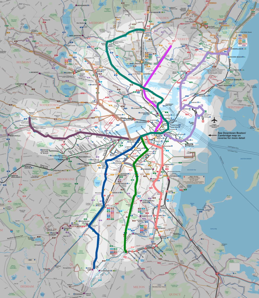
This map shows ½ and 1 mile buffers of the proposed late night
network superimposed on the T’s current route map.
See a full-size map here.

This proposal would use these
trips (with some minor changes) as a baseline for a new, more robust
“All-Nighter” service. This would allow the use of current MBTA bus stops and
routes, and be mostly an extension of current service, not an entirely new
service. It would provide service to most of the area covered by MBTA rail and
key bus routes. The changes include:

  • The primary connection point would move from
    Haymarket to Copley. This significantly shortens many of the routes and
    avoids time-consuming travel through downtown Boston to Haymarket,
    allowing a single route to operate with one vehicle instead of two, thus keeping costs down. In
    addition, Copley is somewhat more central to late night activity centers.
  • The current early-AM routes provide good coverage
    near most rail and “key bus” corridors with the exception of the Red Line
    in Cambridge and the Orange Line north of Downtown. (This plan does not address the longer branches to Braintree and Newton which serve lower-density areas which would have lower ridership and higher operation costs.) To fill these gaps the
    Clarendon Hill route would be amended north of Sullivan Square to follow
    the route of the 101 bus serving Somerville, Medford and Malden. A new
    route would be added following Mass Ave along the Red Line/Mass Ave
    corridor to serve Cambridge, then run through Davis Square and terminate
    at the Clarendon Hill busway.
  • A separate service would be run from Copley to
    Logan Airport. It would follow surface streets from Copley to South
    Station and the Seaport making local stops, use the Ted Williams Tunnel to
    the airport, and then terminate at the Airport Station, where it would
    allow connections to the 117 bus, which would terminate there rather than
    Copley. This bus could be operated or funded by MassPort in partnership with the MBTA, much like the Silver Line, since it would directly benefit the airport. This service
    could be through-routed with the 117 bus to Wonderland via the airport,
    which wouldn’t require additional buses and would eliminate a transfer.
  • Hourly service would operate on all routes, with
    a “pulse” connection at Copley. (What’s a pulse? Here’s the answer.) All buses would be scheduled to arrive at
    approximately :25-:28 past the hour and depart at :32-:35 past, allowing
    customers to transfer between the various lines at this time. A dispatcher
    could hold buses to make sure passengers could connect between lines. With hourly headways, a timed and guaranteed connection is required to provide any network effect and allow access between routes. 
  • Cities served by these routes could set traffic
    lights to “flashing yellow” for the routes between midnight and 5 a.m. to
    best accommodate schedules (this is already the case on many of these
    corridors).
  • Buses to the airport would allow employees to
    arrive a few minutes before the hour, in time for shift start times, and
    would then make a second loop through the airport to pick up employees
    finishing shifts a few minutes past the hour.
  • Airport buses would also allow overnight
    travelers to make their way to downtown by foot, bicycle, Hubway, taxicab
    or TNC (Transport Network Companies like Uber and Lyft), and make the
    “last mile” to Logan on a bus. This is especially important for
    late-arriving flights to the airport at times when there are often few
    cabs available. The MBTA could explore public-private partnerships with
    TNCs or other providers to bring customers to Copley Square to access
    all-night service.
  • The :30-past pulse time would allow workers
    finishing shifts on the hour to access buses to Copley, or walk to Copley
    itself, for connections to their final destination.
This service, based on current
late-night and early-morning published schedules, would require 10 vehicles for
four hours (approximately 1 a.m. to 5 a.m.), or 40 hours of service per day (with an extra hour on Sundays). At
this time, the MBTA operates approximately 10 hours of service covering the
early-AM routes, so the net hours of service would be 30. In addition, these
trips could be added to existing shifts, so rather than a deadhead trip between
a terminal and garage at the beginning or end of service, they would utilize a
bus already in service, saving an additional 6 hours (approximately) of
service, so the net hours per day would be 24.
Assuming a marginal cost per hour
of service of $125 (since this service would require no new capital equipment or vehicle storage, because
most of the bus fleet lies idle overnight, the full cost should not be used for
these calculations), this would cost approximately $1,095,000 per year;
assuming ridership of 843 per night (based on existing counts), the net cost
would be $757,000, with a subsidy of $2.46 per rider, in line with existing bus
subsidies—the cost might be slightly higher if the T needed to assign an inspector to the overnight service and extra police personnel, but they may already be on duty at those hours and could be shifted from overnight layover facilities.
Further, if Massport provided the
link between Copley and the Airport on an in-kind basis (as they do for SL1
airport fares), it would reduce the cost to the MBTA by approximately 10%; if Massport
through-routed such services along the route of the 117 it would reduce the
MBTA’s expenditure by 20%. Thus the range of cost to the T would be somewhere
between $600,000 and $1.25 million, between 7% and 13% of the cost of the most
recent discontinued late-night service. This service would serve approximately
308,000 riders annually.
While “Night Owl” bus service was
run from 2001-2005, it was perceived as serving very different population and purpose than this
proposal, focusing on the “drunk college kid” demographic on Friday and
Saturday nights only (the most recent late night iteration had the same issue, although the T’s equity analysis showed otherwise). While that population would certainly benefit from
overnight service, this service would be aimed directly at providing better
access to overnight jobs—in addition to the airport, most routes would pass
nearby major hospital clusters—especially from low-income areas.
These routes would (unlike the
prior late night services) follow existing bus routes and stops, provide
coverage to much of the region’s core neighborhoods—but not necessarily to each rail station’s front door. For example, the Green Line in Brookline would be served
by the 57 bus along Commonwealth Ave and the 39 bus on Huntington Ave, within a
mile of the B, C and D branch stations in the town, thus providing a similar
level of service more efficiently (and obviating the need to create nighttime-only
bus stops along the rail lines). Most of the densely populated portions of
Boston, Brookline, Cambridge, Chelsea, Everett, Revere, Malden, Somerville and
Medford would be within a mile of service, with additional service to parts of
Newton and Watertown. 

In addition, by following normal bus lines, buses
would use existing, known stops along major streets (rather than requiring
passengers to search for nighttime-only stops adjacent to or nearby rail
stations), and bus numbers could even match daytime routes (for instance routes
could be named: N15/9, N28/SL5, N32/39, N57, N1/88, N93/101, N117) to provide
continuity. The goal is to make the system both useful and easy to understand
both for regular users and customers with less-frequent overnight needs. 
(Using existing routes would also reduce the start-up costs for such a service.)

The T’s current
plans to mitigate the removal of late-night service
are anemic, targeting a
single line or a couple of trips on a single day. This proposal, on the other
hand, would bring overnight service to much of the area which hasn’t had such
service in more than 50 years. It would be a win-win solution. It would benefit
the Fiscal Management Control Board by focusing on low income areas and job
access routes while costing a small fraction of the recent late-night rail
service, and by showing that its goal was to provide better service, not just cut existing trips. But more importantly, it would benefit the traveling public, by
allowing passengers to make trips by transit to major job sites at all hours of
the day.
It would be important, as well, to run this plan with discrete goals in mind; while the late night service was painted as a failure by MassDOT, by comparing the ridership to the previous iteration of late night service, it was an unmitigated success. The T’s mitigation plans would add buses piecemeal to its early morning system with no specific performance metrics. Instead, it should look in to creating a better network with specific goals, and measure the efficacy of the system in providing better connections to people traveling at odd hours.

This plan is designed to be affordable and robust, serving
real needs across the region, responding to social and mobility equity, and
doing so without the need to turn to the private sector, which cannot and will
not offer similar service at such affordable costs. Should it work, it would
enable the MBTA to set a standard for quality 24/7 service—service which is
provided in Philadelphia, Seattle, Cleveland and Baltimore, not to mention peer cities like New York, Chicago and San Francisco—and the kind of
service a city and region like ours both needs and deserves.
*****
Here are sample schedules, assuming a :30-past-the-hour pulse at Copley. Schedules are based on current early-AM service. These times would be repeated hourly at 1 a.m., 2 a.m., 3 a.m. and 4 a.m. daily and 5 a.m. Sunday. Each route would require one vehicle unless otherwise noted.
Ashmont-Andrew-Copley (15 Bus, Red Line Ashmont Branch)
Dep Ashmont Station 1:02
Andrew Station 1:17
Arr Copley 1:28
Dep Copley 1:35
Andrew Station 1:46
Arr Ashmont Station 2:00

Mattapan-Dudley-Copley (28 Bus, Silver Line Washington)
Dep Mattapan Station 1:03
Dudley Square 1:14
Arr Copley 1:25
Dep Copley 1:35
Dudley Square 1:46
Arr Mattapan Station 1:57
Hyde Park-Roslindale-Forest Hills-Longwood-Copley (32 Bus, 34 Bus, 39 Bus, Orange Line, 2 vehicles)
Dep Hyde Park 12:50
Forest Hills 1:04
Longwood Medical Area 1:16
Arr Copley 1:25
Dep Copley 1:35
Longwood Medical Area 1:44
Forest Hills 1:56
Hyde Park 2:10
Watertown-Brighton-Kenmore-Copley (57 Bus, Green Line)
Dep Watertown Square 1:02
Kenmore 1:19
Arr Copley 1:25
Dep Copley 1:35
Kenmore 1:41
Arr Watertown Square 1:58
Clarendon Hill-Davis-Harvard-Copley (Red Line Alewife, 87/88/89 Bus, 1 Bus)
Dep Clarendon Hill 1:03
Davis 1:06
Harvard 1:12
Arr Copley 1:25
Dep Copley 1:35
Harvard 1:48
Davis 1:54
Arr Clarendon Hill 1:57
Malden-Medford-Sullivan Square-Haymarket-Copley (Orange Line North, 101 Bus, 93 Bus, 2 vehicles)
Dep Malden 12:49
Medford 12:59
Sullivan Square 1:07
Haymarket 1:17
Arr Copley 1:25
Dep Copley 1:35
Haymarket 1:43
Sullivan Square 1:53 
Medford 2:01
Arr Malden 2:11
Broad & Ferry-Sullivan Square-Haymarket-Copley
Broad & Ferry 1:00
Sullivan Square 1:10
Haymarket 1:17 (express via Rutherford)
Arr Copley 1:25
Dep Copley 1:33
Haymarket 1:41
Sullivan Square 1:48 (express via Rutherford)
Arr Broad and Ferry 1:58
Wonderland-Chelsea-Airport (Blue Line, 111 bus, 117 bus)
Dep Wonderland 1:31
Chelsea 1:44
Arr Airport 1:55
Dep Airport 2:00
Chelsea 2:11
Arr Wonderland 2:26
Copley-South Station-Airport
Dep Copley 1:32
Arlington via Boylston 1:34
Washington via Boylston 1:35
South Station via Essex 1:38
Seaport 1:41
Terminal A 1:45
Terminal B 1:47
Terminal C 1:49
Terminal E 1:51
Arr Airport Station 1:55
Dep Airport Station 2:04
Terminal A 2:04
Terminal B 2:06
Terminal C 2:08
Terminal E 2:10
Seaport 2:14
South Station 2:18
Washington via Kneeland 2:21
St James via Charles 2:24
Arr Copley 2:27
Alternate Copley-Airport-Wonderland through service (2 vehicles; this would provide better connections downtown but may not serve airport shifts as well from Chelsea and Revere):
Dep Wonderland 12:38
Chelsea 12:53
Terminal A 1:06
Terminal E 1:12
South Station 1:19
Arr Copley 1:25
Dep Copley 1:35
South Station 1:41
Terminal A 1:48
Terminal E 1:54
Chelsea 2:07
Arr Wonderland 2:22

Does your transit system have a pulse?

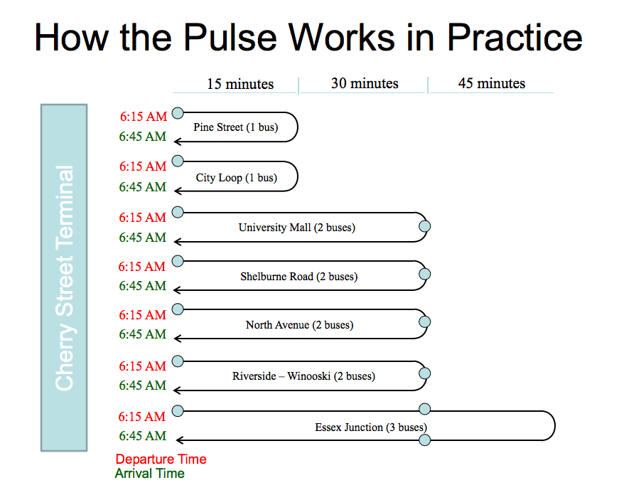
In this post I’ll describe something which is probably unfamiliar to big city transit system users, but which is very familiar for those who use smaller systems: a pulse. A pulse is a timed transfer between multiple routes in one location (or, in some cases, multiple locations) where buses wait for each other in order to allow passengers to transfer between them. Large systems with complex networks generally don’t use pulses both because of the complexity of scheduling and bus frequency: a transfer will often only mean a few minutes’ wait. But with 30- or 60-minute headways on many smaller systems, a pulse is an efficient means to create a usable network.

There are four requirements for a pulse system to be feasible:

  • The system must be small enough. With more than 15 or 20 routes, the complexity of scheduling every bus to one central point will overwhelm the pulse savings, and may also result in inefficient and overlapping routings to reach the pulse location. Some large systems may have pulse features in peripheral locations, or certain times of day.
  • A convergence of routes. Trying to schedule multiple pulse meets at multiple locations is quite complex, and mid-route meets are operationally inefficient since buses usually need a few minutes of schedule padding to allow for variances in travel times. Most pulses take place at a central location where multiple routes lay over. So a network needs to be focused on a single location.
  • Minimal traffic. Pulse networks are based on buses keeping their schedules. In cities with heavy traffic, unless there are busways, a bus that is delayed for five or ten minutes may result in the rest of the pulse being delayed, or passengers missing transfers.
  • Not too much crowding. Crowding on transit is generally a good thing, since it means that people are using the system. Too much crowding, in addition to passenger discomfort, leads to slower run times which, much like traffic can cause a pulse network to break down. In addition, crowding shows that more frequent buses are needed, and pulse networks provide coverage and predictability, but are not easy to scale, because to change the headways on one route, you need to change the headways on all the others.
  • Burlington, Vermont’s 30-minute pulse system shows how routes of
    different lengths operate with different numbers of buses; this is
    more difficult with an hour headway pulse.
  • Routes have to be similar in length. Pulses work best when a single bus can make a roundtrip in an hour, including schedule padding. Issue arise when, say, a destination is 28 minutes of schedule time from the pulse location. You can’t feasibly run it with one bus, since if that bus is at all delayed it will either delay other pulse buses or cause missed transfers. But putting two buses on the route is a poor use of resources, since each bus will now lay over more than half the time. So an hourly pulse network works only with routes where most round trips can be completed in under 50 minutes, and where others are long enough so that resources don’t sit idle. This is less of an issue with 30 minute pulses, as routes can be shorter and still align with the pulse.
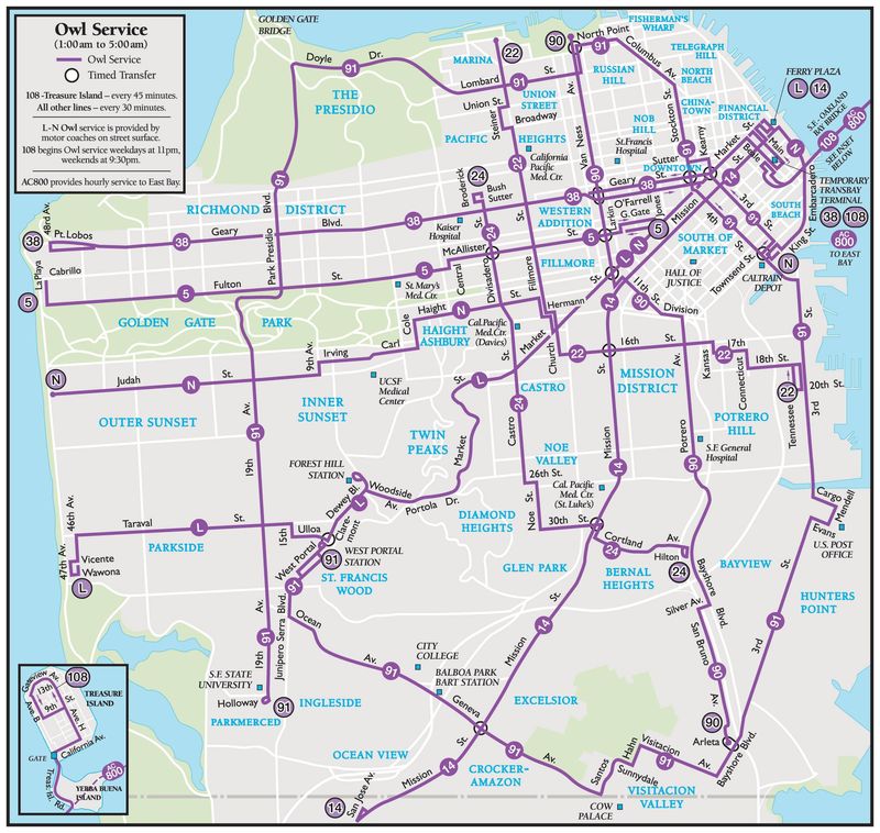
San Francisco’s late night transit services involve a series of timed transfers.
Where are pulse networks run? Pretty much everywhere. For instance, many of the regional transit authorities in Massachusetts run pulse networks, even if they don’t advertise them as such. For instance, if you look at the schedule for nearly every bus in Brockton’s BAT network, it will leave the “BAT Centre” (or the BAT Cave, and after it receives the BAT signal; the Centre has received high praise from Miles on the MBTA; another feature of a pulse system is that it makes it worthwhile to invest in central infrastructure since all routes serve it) at exactly the same time. Buses pull in, passengers transfer, buses pull out. Simple.
Once headways drop below 20 minutes, transfers become very, very difficult if they’re untimed, which is why pulse systems make sense in lower frequency networks. Most of the time, transferring between subways in New York means waiting only a couple of minutes for a train. But after midnight it is often an exercise in futility if you have to change lines, since you may spend as much time waiting in a station for up to 20 minutes as riding the train. Without information on departures or guaranteed transfers, even the country’s only full-service 24-hour subway loses much of its utility.
Jarrett Walker has a good if somewhat wonky description of how a pulse system works here, as does this presentation from the Chittenden Country Transportation Authority (in Burlington, Vermont, where I stole the graphic above). Even San Francisco gets in on the pulse system, for it’s late night service most buses start in a single location, and a few other timed transfers are accommodated as well. In Boston, the transfers to the 117 downtown during early morning service are a proto-pulse, although with a more robust overnight service, a pulse would make more sense.

The T’s “secret” early AM service … unmasked

In 1960, when the MTA cut overnight service (for the first time), some trips were retained. At the time the purpose of these trips was to allow MTA (and later MBTA) fare collectors to get to subway stations. This shadow system was not made “public” until 1999, but by “public” it means that the trips have different numbers combining multiple routes and are shown only on some online timetables and on printed timetables as just a note in very, very small print.

But they’re incredibly useful. Say you have a 6:30 departure from Logan Airport. Without this special knowledge, your only option is to drive and pay to park or take a taxicab or TNC vehicle. Everyone loves paying $30 to get to the airport, right? The T is useless for flights that depart before 7 (the earliest outbound Blue and Silver line services get to the airport around 6 a.m.). Even though the airport runs at full capacity at 6 a.m., many flights depart earlier, and most airport staff have to arrive by 4 or 5 in the morning. Once you learn the secret of the early AM buses, you can get to the airport, or downtown, quite a bit earlier.

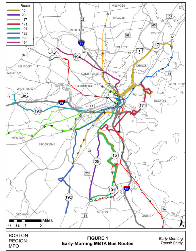
An outdated map of early-AM T services; the 109
service was added in 2014 after a study showed
demand for additional early services.
The network actually serves most of the region!

Here are the routes covered by the buses. There are two sort-of-separate services, the ones which operate to Dudley to connect to the 171 bus at 3:50 and 4:20 and have a later trip downtown. The others have a single trip downtown to meet the 117 for a connection to Logan (as far as I know, the T does not guarantee this transfer by having the 117 hold until connecting buses have arrived). They are as follows (I’ll mention internal route numbers in the 191-197 series since those are sometimes referenced in schedules or online trip planning):

  • The 15 bus operates trips to the airport via Dudley and Andrew from Ashmont, as well as to Haymarket. The later trip follows the Silver Line’s route, the first use the 171; the later trip does not have connecting service to Logan. These trips are shown on the 15 bus schedule; the later trip is officially known as the 191 (see, more confusing than it needs to be).
  • The 28 bus operates from Mattapan to Dudley and meets the 171 and 15 as shown above for transfers. These trips are shown on the 28 bus schedule.
  • The 32, 24 and 39 operate as one continual trip from Hyde Park to Roslindale to Jamaica Plain, Copley and Haymarket, and connect to the 117 to the airport. This trip is shown on the 39 bus schedule, although the route is officially the 192. This route does not operate on Sunday.
  • The 57 bus operates from Watertown to Kenmore, Copley and Haymarket, officially as the 193 although the trip is shown on the 57 bus schedule. This route does not operate on Sunday.
  • The 89 and 93 buses operate from Clarendon Hill to Sullivan Square and on to Haymarket as the 194. This is shown on the 89 bus schedule.
  • The 109 and 92 operate from Broadway and Ferry in Everett to Sullivan Square and on to Haymarket. The portion of the trip to Sullivan is shown in the 109 schedule and the 92 schedule. This should allow a transfer to be made at Haymarket to the 117.
  • The 117 operates several early morning trips inbound to Haymarket in addition to the connection outbound to the airport. 

Is there any information on the MBTA’s website about these services? No! I can’t explain this. The only map I could find was from a 2013 study of these services from CTPS; the T can’t be bothered.

These buses run, they have plenty of capacity (well, most do) and they are, for all intents and purposes, kept secret from the traveling public. The schedules are buried, there’s no information about connecting services to Logan, and no effort has been made to create an “early AM” page with information about which buses run, where the run, and when they run. Most of these buses have been running these routes for close to 60 years—and close to 20 years on public schedules—yet no one knows about them. And the MBTA’s website does its darndest to keep customers in the dark.

Yeah, real helpful

For instance: if you load the 171 bus schedule, you get an error message that there are no trips, because it automatically loads the inbound schedule, which indeed doesn’t have any. You need to load the outbound schedule to see the trips. And the 171 is good for Hubwayers; there’s a station to drop your bike right in Dudley.

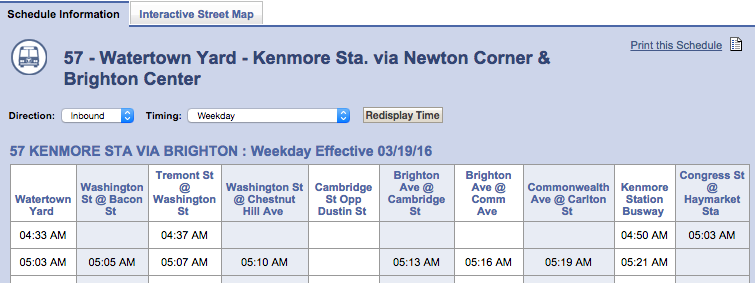
Or check out the 57 bus schedule. It shows a bus leaving Watertown Yard at 4:33 and arriving at Kenmore at 4:50 (a trip which, during rush hour, is scheduled for more than twice as long). Yet there are no times given for any intermediate stops. So does the bus make these stops? Probably. But who’s to say it doesn’t run express? If you want to take the bus from Brighton (Washington Street at Chestnut Hill Avenue) not only are you not given a time, but really no guarantee that the bus would actually run.

Despite this, these routes provide a good base for a discussion about how late-night MBTA service could actually be provided, not just on Friday and Saturday nights, but every day, for allowing low-income workers to get to jobs at the airport and elsewhere. With the T required to mitigate cutting late night service, and currently proposing a very weak mitigation plan, that’s an additional discussion we need to have. But for now, the agency at least ought to tell people about the service they already provide!

Siting Rail Stations: New Bedford

The South Coast Rail plan between Boston and New Bedford and Fall River—should it ever be built—raises a lot of hackles because it costs a lot of money and its benefits are hard to quantify.

(What I’d add is that in addition to current commuters getting a significantly faster trip to Boston than the current highway system, Fall River and New Bedford could be very attractive “gateway cities” with good “bones”—old, attractive housing stock, walkable downtowns—and natural amenities—namely, the Atlantic Ocean—but are currently just a bit too far from the major employment center in New England to take advantage of that. Thus, they can’t provide affordable housing for people with jobs in Boston. One hour trip-time rail service would change that equation dramatically. New Bedford is a lovely town with a lot of vacant land. But traffic renders it isolated from Boston. We need to connect it to the rest of the state.)

But what I want to address today is the siting of the rail station in New Bedford, which—if it is built where the plan currently shows it—would be a major planning failure.

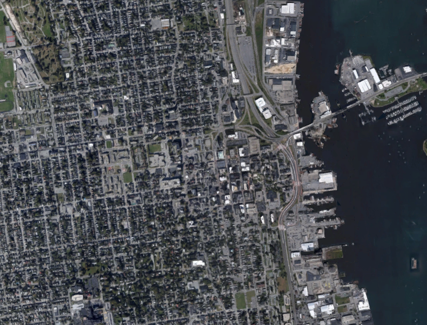
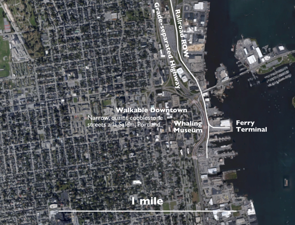
Here’s a raw screenshot of New Bedford: where would you put a train station?

Just looking at the layout of the city, it’s pretty easy to spot the downtown, and the surrounding densely-populated neighborhoods. The rail corridor runs to the right of the roadway east of downtown, so it would make sense to site it somewhere east of downtown, just based on this. Let’s take it a logical step forwards: here is that same map with some annotation of major traffic generators, attractions and transportation nodes:

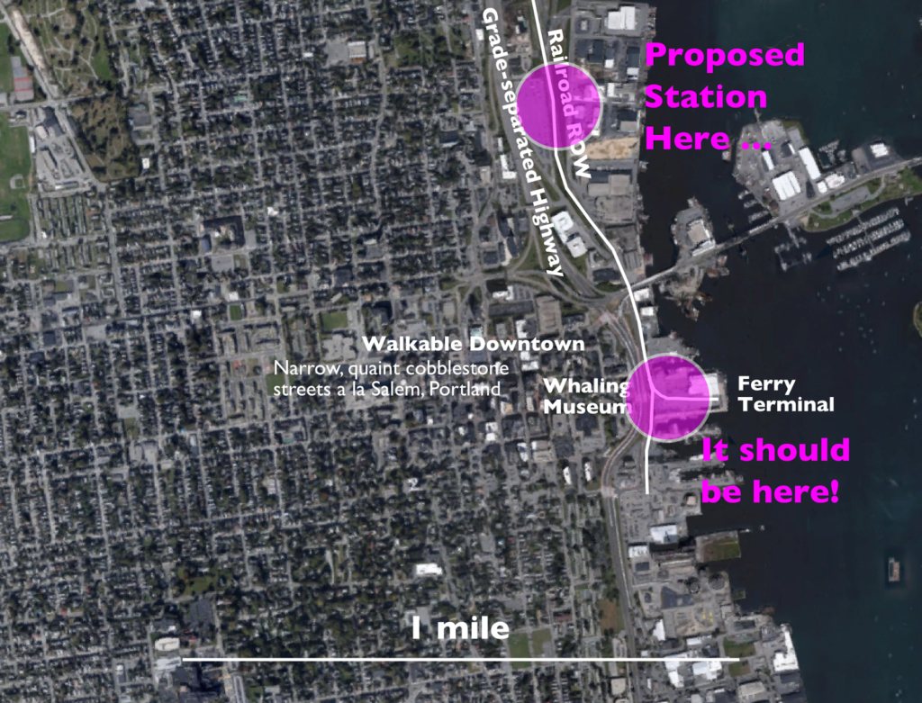
Oh, that makes it even easier. There’s direct access to the ferry terminal with service to Martha’s Vineyard, so instead of having to drive to Woods’s Hole across a clogged Canal bridge, people going to the vineyard could take a train from Boston (or the 128 Station, or even the park-and-ride stations further north along the line) to New Bedford, walk on to a boat, and have a city-to-island trip of 2 hours even. The Whaling Museum would be a stone’s throw away, so it could catch tourists from Boston taking the train to see the attractions (this happens, if there’s service). And it turns out that Downtown New Bedford is really quite nice, with very pleasant and walkable narrow, cobbled streets extending several blocks inland (the city was developed 3/4 miles inland by 1893, although some has succumbed to some pretty dreadful urban renewal), much like Portland, Maine’s Old Port.

Now, where is the proposed station? In about the stupidest place possible.

Should we build a station near downtown, a quick walk across a city street, and adjacent to the ferry terminal? Or half a mile north of downtown, where you have to cross a highway to get there, and nowhere near the ferry? What does MassDOT think? They think that the second option is better. To channel John McEnroe: you cannot be serious. And much like the umpire’s call which led to his outburst, this is a terrible decision.

No. Wrong.

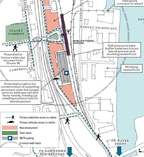
The state’s idea is that the Whale’s Tooth Station—as it’s called–will spur economic development in the currently-industrial area nearby. That may be true. In that case, build a station there, and then have trains terminate downtown. But the zoomed-in image of a site plan for a station in a city like New Bedford should never have an arrow with the words “to Downtown”.

It gets worse: part of the reason they’ve selected the site is that it allows development of a parking structure to serve both ferry passengers and rail passengers. Of course, ferry passenger would have to walk half a mile, or probably take a bus shuttle, and many rail passengers would be driving because the station is really only easy to get to by car. Build it in the right place and you obviate the need for the parking entirely: people driving from further afield can use the King’s Highway station just off the highway a few miles north, and passengers from New Bedford can walk, or take a taxi, or a bus, to the station downtown. Those ferry passengers, instead of driving downtown, can park in King’s Highway, or Taunton, or Westwood (or take a train from Downtown Boston), and take the train to to the ferry.

Why two downtown stations a mile apart? Because New Bedford’s population is concentrated along the coast, and two stations allow easy access without a car. Census tracts immediately adjacent to the coast in New Bedford have population densities in the 5,000–8,000 range, but much of the area is commercial and industrial. Just inland, population densities range from 12,000–18,000 with triple-decker lined streets much like other New England cities—as dense as Boston, Cambridge and Somerville. A city like this should not be served solely by a single car-centric station.

And the multi-modal ferry connection is icing on the cake: current plans call for 75 minute train times, but some documents suggest that sub-60 minute times would be attainable. Given that the plans are to electrify the corridor and that it is, for the most part, arrow-straight—if built to 110 mph standards, the 16 mile tangent section between Taunton and King’s Highway could run in 10 minutes, station-to-station—this should be easy for an limited-stop train; the 1:16 time includes eight stops between 128 and New Bedford, so a summer Friday evening train could easily make the run in an hour. The ferry time from New Bedford to the Vineyard is an hour, although a faster vessel could probably cut that to 40 minutes. With a few minutes to transfer, a two-hour trip to Vineyard Haven would be attainable. This is faster than the current driving-plus-ferry time, which doesn’t include a traffic buffer, and half an hour to park or line up for the ferry. It’s probably just as fast as flying, when you factor in getting to the airport and security. You could get on a train at South Station at 5 o’clock and be on the Vineyard by 7. Try doing that today on a Sunday morning in March, let alone a Friday in July.

All of this would work … if you build the right connection (and, no, I’m not the first to make this argument).

In the 1990s, the T made massive siting errors with the stations in Plymouth, Newburyport and others, which suppresses both ridership and economic development. The as-proposed station location in New Bedford wouldn’t be quite that bad. But it could be much, much better; and New Bedford is a much bigger city than Newburyport or Plymouth. Luckily, we have time to fix it, and do it right.

Let’s use numbers to examine the T’s late night debacle

Surprising no one, the T cut late night service. Why? Because it cost money to operate (like any transit, but still). Because it wasn’t as efficient as rush hour passengers. While we don’t have all of the T’s data, we have some, so let’s look at it, shall we?

1. Passengers per hour on a partial system 
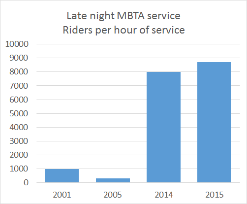
According to the T via BostInno, the late night service carried 16,000 passengers when it ran until 2:30 (two hours of service) and 13,000 when it ran until 2:00 (90 minutes of service). Per hour, this means that the system carried 8000 and then 8700 passengers per hour. From the same post, there are 72,000 passengers during a peak commuting hour, 33,000 during a weekend afternoon, and 14,000 during the first hour of service in the morning. 
Of course, these numbers are misleading, because while all routes run at rush hour, and most run early in the morning and during the weekend, fewer than a dozen bus routes run during the late nights, accounting for 300,000 daily passengers. So the universe of people who could use late night service is only about 70% of the total passengers (and this doesn’t account for reduced train boardings because passengers can’t transfer to a bus that doesn’t run). If only the late night routes ran between 5 and 6 a.m., we’d expect ridership to be just 9800 per hour, or about what late night ridership is. (And if you were to, say, look at a Saturday morning, it’s probably significantly lower.)
So by that logic, should we cut service at any time it is less than, say, 10,000 per hour? Maybe we shouldn’t run service before 6:30 on weekdays? Or before 10 on Sundays?
2. Cost effectiveness compared to rush hours

The T has claimed time and again that late night service isn’t cost effective, because it costs more than average. I’m not making this up: the T’s chief administrator said exactly this. But that’s not how averages work, especially with a peak-demand service like transit. It is always going to cost less per passenger to provide transit at high use times, and more at low use times. The idea is where you want to draw the line. The T paints the picture of this money-hemorrhaging service during late night hours, but only compares it against the overall average, which includes times when the T makes money (yes, during rush hour, the T makes money). A much fairer comparison would be to compare it to, say, all weekend service, or 10 p.m. to end of service on weeknights. Those times probably have similar cost effectiveness. If you compare it to 8:15 a.m., it’s extraordinarily inefficient. But if we had the numbers to compare it to, say, 10:30 p.m. on a Tuesday, or 9:00 a.m. on a Saturday, I bet it would hold its own.
It should be notable that the stated cost for late night service went up from $7.68 in 2014 to $13.39 in 2015, a 74% increase, even as, when measured by passengers per hour, it became more efficient. This might be some more dubious—I mean, innovative—accounting from the FMCB, and it wouldn’t be the first time I’ve accused them of that
3. Defining success (moving the goalposts)

When the Night Owl service ended in 2005, it was a failure: at the end, only 655 passengers were using it nightly over two hours: 327 per hour. (It should be noted that in 2004, the subsidy for the service was higher than the 2013-2015 service.) The current iteration of the service carried 13,000 passengers in just 90 minutes, averaging 8667 per hour, 26.5 times as many. The service didn’t make money, but it was never going to. The beancounters saw the numbers, and declared it a failure. It’s too bad, because based on its ridership, it was a success.
I think that a lot of the work that the fiscal and management control board is doing is worthwhile, and there are certainly places in the MBTA budget where efficiencies can be found to reduce costs. (I’ve, uh, strongly suggested some on this page.) Yet when they want to cut service, they have a knack for massaging numbers to fit their narrative, even if the bigger picture doesn’t support it. This makes the whole operation much less credible: decisions made with poor data should be anathema to their process.
Unfortunately, they’re not.

Penciling out cost savings from a working D Street

Last week, I was quoted in the Globe (*) about the travesty that is the D Street light. The city has said they’ve fixed it, but they haven’t, because oh noes, cars might have to wait! So buses still wait at a 100-second-long traffic light for a green signal. Apparently they tried transit priority and it didn’t work (which is a pitiful excuse; it’s proven technology) and gave up. So we’re back to square one.

Now, there’s a lot of discussion about the T’s huge deficits and the need for fare hikes, but this sort of low hanging fruit is apparently anathema. I’ve calculated it out before, but here is a quick sketch of how much money could be saved in operational costs by having a working transit signal preemption at D Street. One caveat is that at rush hour there might actually be enough bus traffic that signals might not be able to let every bus through at speed: there are 30 buses per direction per hour, so one bus per minute, and the cross traffic needs at least, say, 20 seconds for a pedestrian signal. But given that the current average delay, with deceleration and acceleration, is one minute, even 20 seconds is a heck of a lot better.

Let’s say that the average bus experiences a 45 second delay (this is conservative, especially since schedule padding is required based on the longest time possible to wait, more than three minutes per round trip, or nearly a quarter of a Silver Line Waterfront round trip). For the Silver Line Waterfront shuttle from Silver Line Way to South Station, this accounts for 10% of the total run time, for the SL2 it’s 7% and for the SL1 4%. How many trips are affected? Based on recent schedules:

SL1: 128 trips weekdays, 99 Saturdays, 126 Sundays.
SL2: 142 trips weekdays, 75 Saturdays, 70 Sundays.
SLW: 67 trips weekdays.

Total: 337 trips weekdays, 174 trips Saturdays, 196 trips Sundays. Or 2055 trips per week. And these are one-way trips, so actually 4110 trips per week (this will go up once Silver Line Gateway service begins running). Assuming that each of those trips loses 45 seconds, we’re talking about 3082.5 minutes of operating time per week wasted sitting at the D Street light, or 51.375 hours per week. 52 weeks in a year gives you 2671.5 hours of savings, and at $163 per hour (the cost in 2013 to run a T bus) the cost savings amount to $435,455 per year. It’s probably higher by now.

Let me repeat that: by fixing D Street, the T could operate the exact same amount of service on the Silver Line, but cut costs by nearly half a million dollars. The argument that it would just be built in to schedule padding is spurious, since a more predictable light would save considerably more time, and the run times are short enough that the same amount of service could be operated with fewer vehicles, or the same vehicles could run more frequently. (For instance, if the Silver Line Waterfront service time went from 15 minutes to 13.5, a bus could make 9 round trips in two hours instead of 8.)

If the FMCB is serious about cutting costs, they should be banging down the doors at BTD for this sort of common sense solution to save money. There’s no need to cut service; in fact this would increase service quality. Yet everyone is content to pass the buck, and years later, service never improves.

(* Kind of funny story, but Nicole reached me at the Birkie Expo in Hayward Wisconsin, and I spent ten minutes going on a rant about how dumb everyone at the T and BTD is and basically said “yeah, all of this is on the record.” Because it’s all true. And if you think this blog is excitable about transit, I may get just as excited about ski marathons.)

Fairmount lessons from … Staten Island?

Set apart from the New York Subway system is the Staten Island Railway (SIR), which runs the length of Staten Island and connects to the Staten Island Ferry for the trip to Manhattan and beyond. While it operates somewhat-modified New York City subway equipment, it is part of the national railroad system, so the cars have meet FRA regulations and until 1997, fares were collected by on-board conductors. Since then, fare collection has been simplified and staffing reduced to a single operator.

Conductors make some sense on commuter rail systems: they have to raise and lower stair traps at stations with different platform levels and collect fares where trains pass through different zones. (Could zones be simplified on most US Commuter railroads? Yes, but that’s the topic of a different post.) But the SIR runs subway-style equipment at all-high-level platforms with one fare, so all the conductor was there for was to to collect the same fare from everyone. And unlike most subway lines in New York, nearly everyone on the train was traveling to one station: the Saint George terminal and the connection to Manhattan. So when the MTA came out with the Metrocard, the conductors disappeared, turnstiles and MetroCard machines appeared at Saint George, and passengers paid a fare upon entry and exit (similar to the MBTA’s exit fares when higher fares were charged for the Quincy extension). A few years later, after many passengers made the short walk to Tompkinsville, fare gates were added there, too.

But there was no need to put fare gates on the rest of the system. Most people use the line to access the ferry and get to Manhattan, and the cost of installing fare mechanisms at the other 20 stations on the line was far too high for the number of passengers using them, so travel between intermediate stops is free.

There aren’t many other systems that could use such a procedure: most either have multiple fare zones or multiple terminal stations (shared with other services, making faregates less feasible), or both, making it much harder to implement these sorts of efficiencies. But in Boston, the Fairmount Line meets both these criteria, and would be a good candidate for this sort of fare system.

Now, before we get too far in to the weeds, let’s posit that the Fairmount Line at some point gets more frequent service (the SIR runs every 15 minutes at rush hour and 30 minutes midday to match the ferry schedule, but the Fairmount Line should really run every 10 to 15 minutes), preferably from DMUs (or as this page has argued, EMUs). In the short term, four coaches and a diesel engine could be used for more frequent service, although doors might need to be automated. It wouldn’t have the look and feel of a subway, but it could be operated as much as possible as one (frequent service, all door boarding).

Most Commuter Rail trains operate with three crew members: an engineer and two conductors; at rush hours, there may be additional conductors. Their direct responsibilities don’t really extend beyond collecting fares and operating doors. These are important functions, especially for trains with 1000 passengers which run on lines which don’t have full-length high platforms and with multiple fare zones. But the Fairmount Line has neither. Tripling the current headways to 15 minutes at rush hours and 20 minutes at other times could be attained with the current level of staffing (you need more trains, but not more staff, and the marginal cost of running a train is half staffing costs; likely lower with EMUs). That doesn’t quite get you to subway levels of service, but it’s a lot better than the hourly service today. There may be FRA issues with removing personnel from the trains, but the FRA does grant waivers, and the SIR operates under FRA rules with one person train operation. Other than a low-level platform at Readville, union issues and entrenched bureaucracy, what would keep the T from doing the same with the Fairmount Line?

Most everyone would pay their fare. The easternmost platform at South Station—tracks 12 and 13—could be set aside for Fairmount passengers with Charlie Card gates at the end of the platform, and a couple of ticket machines on the inside for passengers arriving without fare. Charlie Cards could (probably) be set up to allow a free transfer to and from the Red Line. If South Station is expanded, a Fairmount Terminal could be built with a direct transfer to the Red Line within fare control through the station’s basement, although it’s unlikely that the never-used underground loop could be repurposed for rail service, it could serve as a pedestrian passageway.

Since the first station on the line at Newmarket is a relatively-unpleasant, two-mile walk from South Station, there would be no Tompkinsville issue. According to 2012 counts, more than 99.5% of trips on the Fairmount Line were to and from South Station. With more stations open since then and possible free rides, a few more people might use the train for inter-Dorchester travel. Even then, the cost of collecting fares would still far exceed the fares collected, and any such travelers would not be able to access the rest of the system without paying an additional fare.

Unfortunately, the Fairmount Line is an ugly stepchild of the already rather ugly MBTA Commuter Rail system. Without increased service, it seems destined to serve few riders; while it provides relatively fast travel it is so infrequent riders are usually better off taking a bus and transferring to the subway. But with a relatively small investment in linking the electrification already present at both ends of the route, and with some common-sense fare payment initiatives aping the SIR, it could act much more like subway line straight in to the core of the city, with easy connections to other subway lines and the airport. And in a disadvantaged community with poor transit, this would go a long way towards better job access and prospects for workers there.