
The South Coast Rail plan between Boston and New Bedford and Fall River—should it ever be built—raises a lot of hackles because it costs a lot of money and its benefits are hard to quantify.
(What I’d add is that in addition to current commuters getting a significantly faster trip to Boston than the current highway system, Fall River and New Bedford could be very attractive “gateway cities” with good “bones”—old, attractive housing stock, walkable downtowns—and natural amenities—namely, the Atlantic Ocean—but are currently just a bit too far from the major employment center in New England to take advantage of that. Thus, they can’t provide affordable housing for people with jobs in Boston. One hour trip-time rail service would change that equation dramatically. New Bedford is a lovely town with a lot of vacant land. But traffic renders it isolated from Boston. We need to connect it to the rest of the state.)
But what I want to address today is the siting of the rail station in New Bedford, which—if it is built where the plan currently shows it—would be a major planning failure.
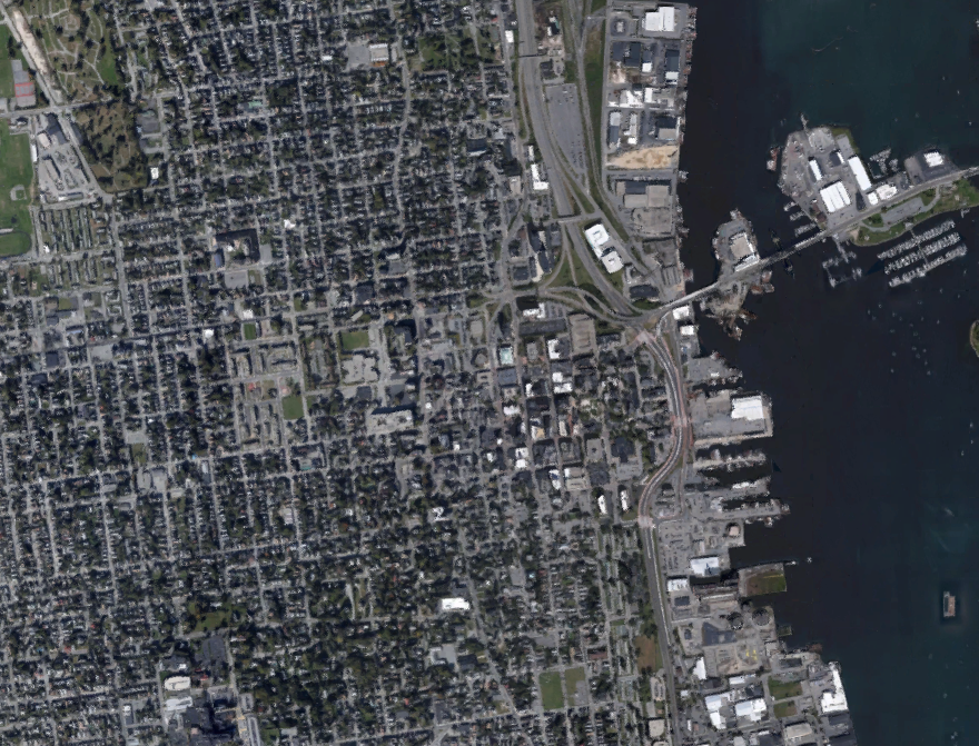
Here’s a raw screenshot of New Bedford: where would you put a train station?
Just looking at the layout of the city, it’s pretty easy to spot the downtown, and the surrounding densely-populated neighborhoods. The rail corridor runs to the right of the roadway east of downtown, so it would make sense to site it somewhere east of downtown, just based on this. Let’s take it a logical step forwards: here is that same map with some annotation of major traffic generators, attractions and transportation nodes:
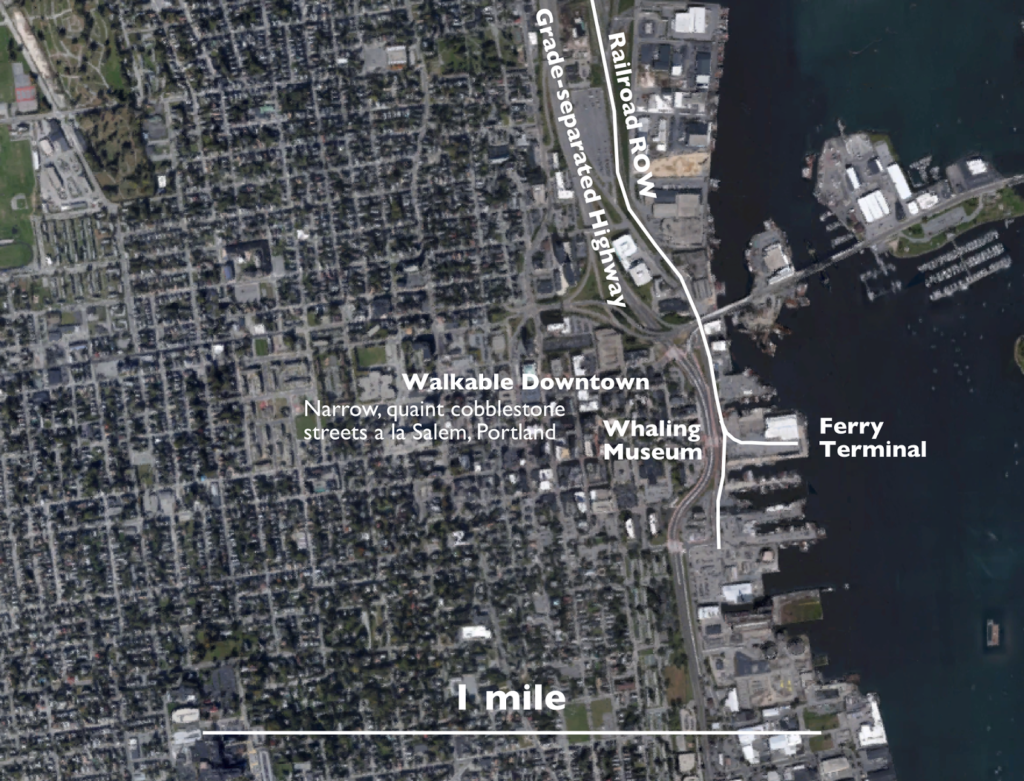
Oh, that makes it even easier. There’s direct access to the ferry terminal with service to Martha’s Vineyard, so instead of having to drive to Woods’s Hole across a clogged Canal bridge, people going to the vineyard could take a train from Boston (or the 128 Station, or even the park-and-ride stations further north along the line) to New Bedford, walk on to a boat, and have a city-to-island trip of 2 hours even. The Whaling Museum would be a stone’s throw away, so it could catch tourists from Boston taking the train to see the attractions (this happens, if there’s service). And it turns out that Downtown New Bedford is really quite nice, with very pleasant and walkable narrow, cobbled streets extending several blocks inland (the city was developed 3/4 miles inland by 1893, although some has succumbed to some pretty dreadful urban renewal), much like Portland, Maine’s Old Port.
Now, where is the proposed station? In about the stupidest place possible.
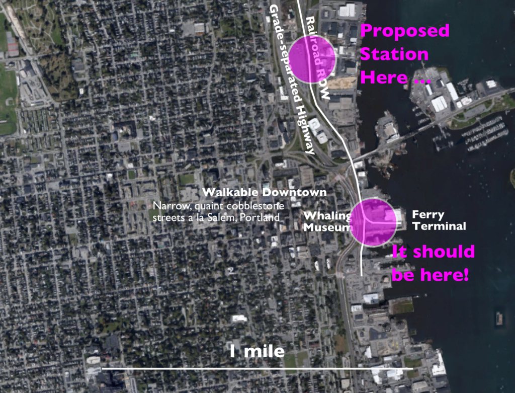
Should we build a station near downtown, a quick walk across a city street, and adjacent to the ferry terminal? Or half a mile north of downtown, where you have to cross a highway to get there, and nowhere near the ferry? What does MassDOT think? They think that the second option is better. To channel John McEnroe: you cannot be serious. And much like the umpire’s call which led to his outburst, this is a terrible decision.
 |
| No. Wrong. |
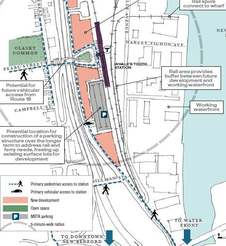
The state’s idea is that the Whale’s Tooth Station—as it’s called–will spur economic development in the currently-industrial area nearby. That may be true. In that case, build a station there, and then have trains terminate downtown. But the zoomed-in image of a site plan for a station in a city like New Bedford should never have an arrow with the words “to Downtown”.
It gets worse: part of the reason they’ve selected the site is that it allows development of a parking structure to serve both ferry passengers and rail passengers. Of course, ferry passenger would have to walk half a mile, or probably take a bus shuttle, and many rail passengers would be driving because the station is really only easy to get to by car. Build it in the right place and you obviate the need for the parking entirely: people driving from further afield can use the King’s Highway station just off the highway a few miles north, and passengers from New Bedford can walk, or take a taxi, or a bus, to the station downtown. Those ferry passengers, instead of driving downtown, can park in King’s Highway, or Taunton, or Westwood (or take a train from Downtown Boston), and take the train to to the ferry.
Why two downtown stations a mile apart? Because New Bedford’s population is concentrated along the coast, and two stations allow easy access without a car. Census tracts immediately adjacent to the coast in New Bedford have population densities in the 5,000–8,000 range, but much of the area is commercial and industrial. Just inland, population densities range from 12,000–18,000 with triple-decker lined streets much like other New England cities—as dense as Boston, Cambridge and Somerville. A city like this should not be served solely by a single car-centric station.
And the multi-modal ferry connection is icing on the cake: current plans call for 75 minute train times, but some documents suggest that sub-60 minute times would be attainable. Given that the plans are to electrify the corridor and that it is, for the most part, arrow-straight—if built to 110 mph standards, the 16 mile tangent section between Taunton and King’s Highway could run in 10 minutes, station-to-station—this should be easy for an limited-stop train; the 1:16 time includes eight stops between 128 and New Bedford, so a summer Friday evening train could easily make the run in an hour. The ferry time from New Bedford to the Vineyard is an hour, although a faster vessel could probably cut that to 40 minutes. With a few minutes to transfer, a two-hour trip to Vineyard Haven would be attainable. This is faster than the current driving-plus-ferry time, which doesn’t include a traffic buffer, and half an hour to park or line up for the ferry. It’s probably just as fast as flying, when you factor in getting to the airport and security. You could get on a train at South Station at 5 o’clock and be on the Vineyard by 7. Try doing that today on a Sunday morning in March, let alone a Friday in July.
All of this would work … if you build the right connection (and, no, I’m not the first to make this argument).
In the 1990s, the T made massive siting errors with the stations in Plymouth, Newburyport and others, which suppresses both ridership and economic development. The as-proposed station location in New Bedford wouldn’t be quite that bad. But it could be much, much better; and New Bedford is a much bigger city than Newburyport or Plymouth. Luckily, we have time to fix it, and do it right.