A Complete Mass Ave in Cambridge

Cambridge is in the process of starting a citywide master plan (right now it’s in the naming phase). The major thoroughfare in Cambridge is Massachusetts Avenue (Mass Ave for short, of course), and it is pretty much the only street in Cambridge that is more than two lanes each way. Except for a couple of locations, north of Harvard Square Mass Ave is 72 feet wide, and it could be a great street.

Unfortunately, it’s not. It’s basically a highway.

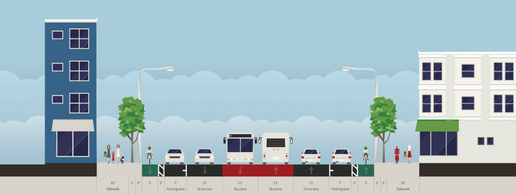
Two wide lanes of traffic each way, parking and a median. Are we in Cambridge, or LA?
All diagrams shown made in Streetmix, which is a fantastic tool for this sort of exercise.

And that needs to change. The street currently serves two functions well: traffic and parking. There’s minimal traffic on Mass Ave because there is ample capacity (the bottlenecks are at either end of Cambridge). There is plenty of parking; nearly the entire stretch of the street has parking on both sides. And since the street is so wide, there is a median to help pedestrians cross, discourage left turns and make the traffic even faster. It is also a concrete waste of six perfectly usable feet.

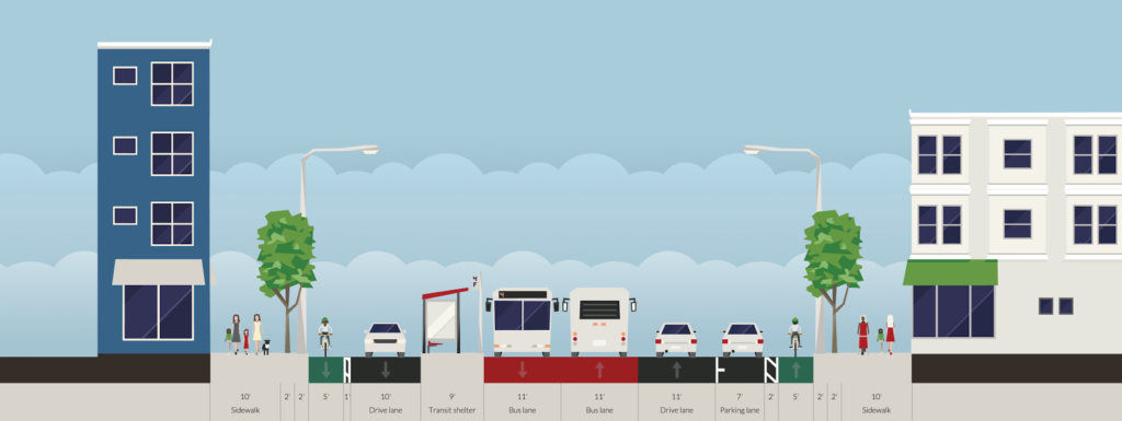
The street does have 14 feet of pedestrian facilities on either side, but these are hardly enough for the various uses there, which include bus stops, bike racks, sidewalk cafes, building access, power and light poles, etc. And the current lane width is ridiculous. Each side of the street is 33 feet wide: a 7 foot parking lane and two 13 foot travel lanes. Considering that Interstate travel lanes are only 12 feet wide, and 10 foot lanes are used throughout much of Cambridge, this is far, far more width than necessary, meaning that with the median there are 18 wasted feet of space on Mass Ave. Wider lanes cause drivers to speed, which endangers other street users. As for transit, the 77 bus limps along Mass Ave, stuck in traffic and pulling to the curb at every stop, only to wind up stopped at a light behind the cars that passed it.

We need to re-plan Mass Ave, and we need to rethink our priorities. In the 1950s, when the removal of transit safety zones in Mass Ave sped traffic and the end of the streetcars (at the City’s behest, no less), the main priority was vehicular traffic, with no mind paid to cyclists, little to buses, and not much to pedestrians. This is nearly completely backwards. How we should plan is:

  1. Pedestrians. Every street user other than a pass-through driver is a pedestrian. We need to make sure crossings are manageable, sidewalks are wide enough, and traffic is slow enough to be safe.
  2. Transit. Right now there are four bus lines along Mass Ave, the 77, 83, 94 and 96, carrying 13,000 passengers daily (as opposed to 20,000 vehicles). In addition, the street serves as the pull-out route for the 71 and 73 buses, serving 10,000 more. At rush hour, there may be a bus every two or three minutes.
  3. Cyclists. Safe cycling infrastructure is imperative for Mass Ave, as it is the straightest line between Arlington and North Cambridge and Harvard Square and points south and east. It is also the main commercial street for the neighborhood, and safe cycling facilities will allow residents to access businesses without driving. Rather than shunt cyclists to roundabout side streets, we should give them a safe option on Mass Ave. 
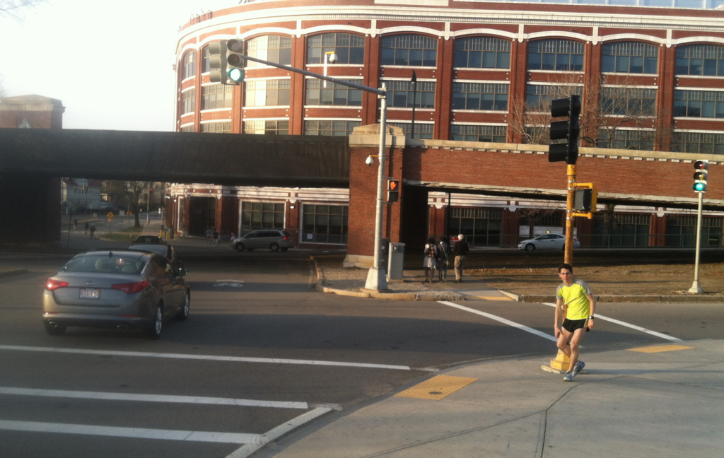
  4. Cars. Yes, we need to provide for vehicles. We need a lane in each direction, enough parking to serve businesses (likely on both sides) and turn lanes in a few selected locations. Do we need two lanes in both directions? Certainly not; there are plenty of one-lane roadways which accommodate as much traffic as Mass Ave. And if we build a road that’s better for pedestrians, cyclists and transit users, many of the current drivers will travel by foot, bicycle or bus instead. We also need parking, and there’s enough for parking on each side. It would be eliminated where there are bus stops, but with fewer overall stops there would be only a minor loss of spaces. And with better non-driving amenities, fewer people would drive, anyway.
With that said, here are some Streetmix diagrams of the roadway, and an overhead sketch of how they would mesh together:

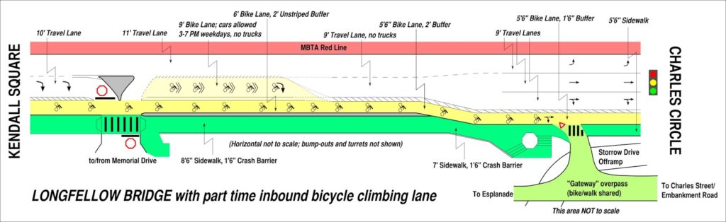
This is a typical section of street. The curbs and sidewalks are unchanged, but everything else is. Cars get one lane, plus parking. There are center bus lanes, which also allows cars to pass people parking, or a double-parked car, although this will require enforcement to keep drivers from using the bus lanes for travel or turns. Each lane is 11 feet wide, and emergency vehicles would also use the bus lanes to bypass traffic. On each side of the street, there is a 5 foot bike lane separated from parked cars by a 2 foot buffer (the bike lanes could either be at street or sidewalk level). This would be the baseline configuration of the street.

Now, how do people get on to the bus? A bus stop. Back in the day, this would be called a safety zone, so that passengers could safely wait for and board a streetcar in the center of the street. Mass Ave had these until the ’50s, as did Central Square, as did many other cities. (In fact, they still have them in Philadelphia and San Francisco.) Today, we’d call them part of Bus Rapid Transit. They’d be paired with a crosswalk to allow people to easily access the station, and allow buses to quickly and safely board and discharge passengers without having to pull in and out of traffic. The travel lane would be shifted towards the side of the road in these cases, and the parking would disappear; this chicane would also serve as a traffic calming measure. Of course, there would be no more curbside bus stops taking up parking. This would also reduce the crossing distance of the roadway at bus stops to 47 feet, although less since there would be refuge between the bike lane and the travel lane opposite the bus stop; meaning the longest distance would be only 33 feet.

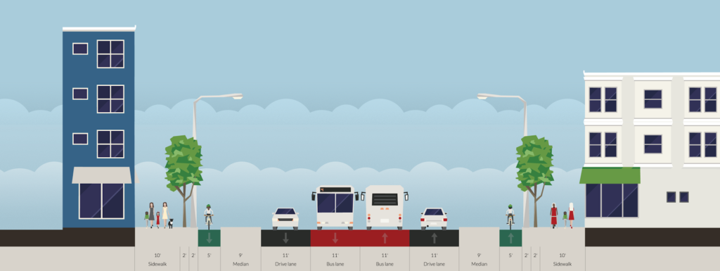
When a crossing of the roadway is desired away from a bus stop, the parking lanes would be replaced with curb bumpouts beyond the cycle track, meaning that pedestrians would only have to cross four lanes of traffic—44 feet—instead of the current 72. Crosswalk treatments would be included in the cycletrack to warn cyclists of the pedestrian crossing.

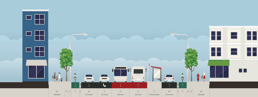
A turn lane could be accommodated by reducing parking in a manner similar to a bus stop. This would often be paired with a bus stop opposite the turn lane, with through traffic proceeding straight and the turn lane becoming the bus stop.

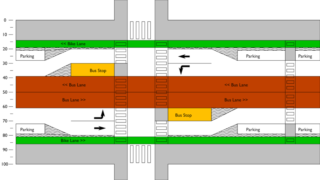
What would it look like from above? Something like this:

In the 1950s, we planned Mass Ave for cars. Cambridge can do better. In 2015, we were honored to have built what was described as the best new bicycling facility in the nation. It’s high time we remake Mass Ave, this time for everyone.

Longfellow Bike Count: Year 2

It’s kind of hard to believe that it’s been more than a year since my first Longfellow Bridge bike count, but it has. I’ve posted just a few times since then about the bridge, and seen the inbound lanes deconstructed, the towers come down, and, arch-by-arch, the bridge is now being rebuilt. I even went out in the middle of winter (and by out, I mean in to someone’s office with a view of the bridge) and counted about 90 bikes per hour: 30% of the previous summer’s crossings. (I think I tweeted this during the winter but didn’t write a whole post.)

So it was high time for a new count. I waited for a morning with good weather (and when I wouldn’t miss November Project) and set off for the bridge. After chatting with the DPW workers on my street about Hubway, I didn’t make it on to the bridge until 7:45, but that meant I was there in plenty of time to hit the peak morning bike rush hour, which (still) occurs from approximately 8:10 to 9:10 on the Longfellow. While at first the bike counts seemed flat or even down, once the rush got cranking, it became clear that there are more bicyclists this year than last.

Just to review, here are the bike counts for the peak hour from last year:

Wednesday, June 19, 2013: 267 bicyclists (8:12 – 9:12)
Tuesday, July 30, 2013: 308 bicyclists (8:08 – 9:08)
Tuesday, October 15, 2013: 298 bicyclists (8:11 – 9:11)

Here’s what I found this June (on the 24th, a Tuesday). The counts today peaked from 8:07 to 9:15 (that is to say, the 8:07 – 9:07 hour and the 8:15 – 9:15 hour saw the same counts). And the number of cyclists during those 60 minute blocks?

384

That’s one bike every nine seconds for an hour. Compared with the highest count last year in July, it’s an increase of 25%. Compared with the average of the three counts last year, it’s an increase of 32%. In a single year.

I can’t think of any single factor that would have increase bicycle usage by that much, other than more people riding bikes. So, contrary to any mitigating factors, I’m operating under the assumption that bicycling eastbound across the Longfellow is up by at least 25% this year. Between 8:30 and 9:00, there were 221 cyclists crossing the bridge and only 187 vehicles: 18% more bikes than cars. There were a few moments where the bridge looked downright Copenhagenish. With more bicyclists than vehicles crossing the bridge at peak times, perhaps it’s time to revisit the design and give bikes more than 20% of the road’s real estate.

What’s wrong with this picture?

A simple question: What is wrong with this picture?

The answer: the cars have a green light to go straight, but the pedestrians have to wait. This signal is optimized for vehicle movement, at the expense of the safety and convenience of pedestrians. Considering that this is an area with high pedestrian use—at the northern end of the BU Bridge along the Paul Dudley White bike path—it is nonsensical that such priority is given to vehicles rather than pedestrians. The only way to get a “walk” light is to push the “beg button” on either side of the crosswalk—otherwise the light stays at “don’t walk” encouraging drivers to make the turn without looking for pedestrians.

But it’s worse. Look to the right. There’s a second traffic light showing green. Cars driving a downgrade are encouraged to make the turn as fast as possible (the tapered corner doesn’t help), at the expense of the pedestrians. Want to cross? Wait until a red light. Although it’s not like that will even help that much: cars can still take a right on red (after “stopping”).

What could be changed to make this intersection safer?

  1. The once-you’ve-turned light should be removed or relocated. Right now it is too far around the curve. By the time a driver sees it in its green phase, they are already crossing the crosswalk. In its red phase, a driver who had missed the main signal would have already crossed the crosswalk. It could be replaced with a “yield to pedestrians in crosswalk” sign.
  2. The walk signal should be changed to display a “walk” sign with every green phase of the light. This will allow for safer pedestrian movement and will not relegate pedestrians to play second fiddle to automobiles at this intersection. It could be enhanced with conspicuous “yield to pedestrians in crosswalk” signage.
  3. At slightly more cost (the first two items would simply require reprogramming or removing the lights) the curb should be bumped out to create more of a right turn movement. This will require vehicles to slow down as they make the turn to cross the crosswalk, which will allow them to better look for pedestrians crossing from one side of the roadway to the other.

This is traffic calming at its simplest: traffic throughput will not likely be curtailed (the bottlenecks in this intersection are not due to this light, but are at other locations) and it would significantly enhance conditions for more vulnerable road users.

Design in isolation

There are several recent projects in the Boston/Cambridge area—some of which have been covered on this page—that have been in the conversation recently. One major flaw of all of these is that they do little to combine the features of multiple projects but rather are viewed in isolation, even though they often border each other and, in many cases, deal with the same roads, paths and transitways. These include:

These are all worthy projects, and it’s mildly infuriating that there is no overarching planning agency which can corral these in to one cohesive plan. Right now, it’s an alphabet soup which includes MassDOT, DCR, Cambridge, Boston, the MBTA, Harvard and MIT (they own part of the Grand Junction right of way). The issue is that these projects are often viewed as singular entities, and not in relation to the greater transportation ecosystem. For instance, I see the Allston campus, Cambridge Street Overpass and Turnpike Straightening as inextricably linked, with no small connection to the DCR paths and, down the line, the Bowker overpass. A vehicle driving over the Bowker Overpass may well have come from Harvard Square, via a DCR roadway and through the Turnpike interchange. And, heck, with better transit or bicycling connections, that vehicle might not be there at all. 
Instead of single-item traffic studies, we need to take a holistic view of the transportation infrastructure in the region, and decide what we want to see in 20 or 30 years: slightly realigned roadways which still prioritize funneling as much traffic as possible to the detriment of other uses, or a more complete transportation system. Most of the infrastructure in question is 50 or more years old, and will need to be rebuilt (or reconsidered) in coming years. Instead of rebuilding the broken infrastructure we have, we need to take a broader view of what we could create. Since we’re going to have to spend the money anyway, we might as well spend it wisely now, rather than have to fix yesterday’s problems tomorrow.

This page will attempt to do so in the near future.

Massachusetts’ DMU plan could well provide better rail service

Last year (oh, wait, in 2012—gosh) I wrote about the sorry state of affairs of the MBTA’s commuter rail system. Outside of rush hour, trains travel infrequently and on seemingly random schedules. Even in closer-in, denser areas, service is provided only every couple of hours. (Oh, yeah, and service is slow, too.) There is probably demand for better service but little supply, and it’s partially a cost issue: running full, 1000-passenger commuter trains (with poor acceleration) is a losing proposition when few seats are filled.

Enter the DMU. The diesel multiple unit, while sparsely used in the US, is a frequent sight abroad, providing service at times when a full trainset is not needed. They leverage the direct connections between town centers that exist along rail lines, allowing fast service to the city center without rolling empty cars through the midday and evening. The plan imagines several lines utilizing DMUs on rail segments inside 128—most of which do not have paralleling subway service:

 (The full report, which appears to have been scanned as a PDF, is here.)

If implemented, this would go a long way towards improving service on several underserved corridors. The Fairmount Line currently is served infreqently by full-length commuter trains, a complete mismatch of service. Lower capacity and better acceleration would provide a much better benefit there. The Worcester Line—which will soon have added service—provides very little service in Newton, the most densely-populated portion of the line (it is served by express buses, which crawl through traffic on the Turnpike). Better service to Lynn will provide some of what a far-costlier rapid transit connection would—faster and more frequent service to Boston, and service to Woburn will provide better connectivity north of Boston, as well as further reducing the run times for trains to Lowell, currently one of the faster trips in the system, and one which, if the state of New Hampshire pays, could be extended northwards to the granite state to provide an alternative for the traffic-choked I-93.

The most interesting piece here is the inclusion of the Grand Junction through Cambridge. This page would argue for a complete rebuild of this line, with grade separation and electrification, and its operation as a crosstown link between North Station, Cambridge and Allston, currently a serpentine trip by car, much less by transit. It also would provide better access to the fast-growing Cambridge area which is currently poorly-served by highways and at the whim of the over-capacity Red Line. Currently, commuting from west of Boston to Cambridge is a bit of a black hole; there is no good connection between the Worcester Line and Cambridge without going all the way to South Station and backtracking across the Red Line. The Grand Junction is an underutilized piece of infrastructure which could be put to very good use.

What really matters is how the MBTA decides to implement DMU service. (That is, if it can be funded and overcome local opposition; double-dipping Cambridge City Councilman and State Rep Tim Toomey helped to quash a plan to route some commuter service over the Grand Junction in 2010. Needless to say, he did not receive my vote in recent council elections). If it uses it as a cost-saving measure to run the same level of service with less equipment, it will simply maintain the status quo. For instance: there are only eight commuter rail trains from the stations in Newton to Boston daily. And the Fairmount Line has 60 minute headways with no evening or weekend service. Running the same level of service with different equipment would be a wasted opportunity (if a minor cost savings).

If the state provides faster and more frequent service to these lines, say, with 15 or 20 minute headways all day, it will come much closer to providing a transit level of service, and actually providing service to these communities. With new stations at Yawkey, near New Balance and the intermediate “West Station” the Worcester Line would provide better connections through an underserved portion of Boston and Newton (with frequent, timed shuttle service across the Grand Junction a dramatic bonus). And the Fairmount Line, which currently provides piss-poor service to one of the states most disadvantaged communities, could prove an economic lifeline, if only the trains ran more than hourly.

And if DMUs are successful, they could be implemented in other parts of the system. Why run a full trainset at off-peak hours from Newburyport to Boston when a transfer at Beverly would provide the same level of service? Perhaps instead of the hourly locomotive-hauled train from Boston to Lowell, half-hourly DMUs would double the service at a minimal additional cost. Perhaps DMUs could provide service further west of Worcester to Springfield and Amherst. Hopefully, the state sees DMUs as a tool, not as a cost-cutting measure. If they implement this service better than they photoshopped the map, they could dramatically improve travel in Massachusetts.

Longfellow Bike Count

One of the issues I’ve touched on in the Longfellow Bridge series is the fact that there as no bicycle count done at peak use times—inbound in the morning. The state’s report from 2011 (PDF) counted bicyclists in the evening, and shows only about 100 cyclists crossing the bridge in two hours. Anecdotally, I know it’s way more than that. At peak times, when 10 to 20 cyclists jam up the bike lane at each light cycle, it means that 250 to 500 or more cyclists are crossing the bridge each hour. So these numbers, and bridge plans based on them, make me angry.

But instead of getting mad, I got even. I did my own guerrilla traffic count. On Wednesday morning, when it was about 60 degrees and sunny, I went out with a computer, six hours of battery life and an Excel spreadsheet and started entering data. For every vehicle or person—bike, train, pedestrian and car—I typed a key, created a timestamp, and got 2250 data points from 7:20 to 9:20 a.m. Why 7:20 to 9:20? Because I got there at 7:20 and wanted two hours of data. Pay me to do this and you’ll get less arbitrary times.

But I think it’s good data! First of all, the bikes. In two hours of counting, I counted 463 bicyclists crossing the Longfellow Bridge. That’s right, counting just inbound bicyclists, I saw more cyclists cross the Longfellow in one direction than any MassDOT survey saw in both directions. The peak single hour for cyclists was from 8:12 to 9:12, during which time 267 cyclists crossed the bridge—an average of one every 13.4 seconds. So, yes, cyclists have been undercounted in official counts.

Are we Market Street in San Francisco? Not yet. Of course, Market Street—also with transit in the center—is closed to cars. [Edit: Market Street is partially closed to private vehicles, with plans being discussed for further closures.] And at the bottom of a hill, it’s a catchment zone for pretty much everyone coming out of the heights. They measured 1000 bikes in an hour (with a digital sensor, wow!), but that was on Bike to Work Day; recent data show somewhat fewer cyclists (but still a lot).

I also counted vehicles (1555 over two hours; 700 to 800 per hour, including three State Troopers and one VW with ribbons attached that passed by twice), inbound pedestrians (about 100, evenly split between joggers and walkers, although there were more joggers early on; I guess people had to get home, shower and go to work) and even inbound Red Line trains (30, with an average headway of 4:10 and a standard deviation of 1:50). I didn’t count outbound pedestrians, or the exact number of people I saw stopping to take pictures (at least three on my little nook of the bridge).

But did you come here for boring paragraphs? No, you came for charts! Yay charts! (Also, yay blogging at 11:20 p.m. when I should be fast asleep. Click to enlarge.)

First, bikes. Cyclists crossing the bridge started out somewhat slow—the moving average for the first 20 minutes was only one or two per minute. But the number of cyclists peaks around 8:40—people going in to the city for a 9:00 start—before tapering off after 9. I’ve written before about seeing up to 18 people in line at Charles Circle which is backed up by these data; the highest single minute saw 11 cyclists, and there were four consecutive minutes during which 36 bikes passed. At nearly 6 bikes per minute for the highest half hour, it equates to nearly 360 bikes per hour—or 10 per 100 second light cycle. Too bad we’re all squeezed in to that one little lane. (Oh, here’s a proposal to fix that.) If anything, these numbers might be low—the roads were still damp from the overnight rain early this morning.

What was interesting is how few Hubway bikes made it across the bridge—only 25, or about 6% of the total. With stations in Cambridge and Somerville, it seems like there is a large untapped market for Hubway commuters to come across the bridge. There are certainly enough bikes in Kendall for a small army to take in to town.

Next, cars. The official Longfellow traffic counts show about 700 cars per hour, which is right about what my data show. What’s interesting is that there are two peaks. One is right around 8:00, and a second is between 8:30 and 9:00. I wonder if this would smooth out over time, or if there is a pronounced difference in the vehicular use of the bridge during these times. In any case, 700 vehicles per minute is not enough that it would fill two lanes even to the top of the bridge, so the second lane—at this time of day, anyway—is not necessary on the Cambridge side.

I also tracked foot traffic. I did my best to discern joggers and runners from commuters. Joggers started out strong early, but dwindled in number, while commuters—in ties and with backpacks and briefcases—came by about once every minute. I was only counting inbound pedestrians, and there were assuredly more going out to Kendall. Additionally, I was on the subpar, very-narrow sidewalked side; the downstream sidewalk is twice the width (although both will be widened as part of the bridge reconstruction).

And I counted when the trains came by. In the time that 2500 bikes, pedestrians and cars crossed the bridge, 30 trains also did. Of course, these were each carrying 500 to 1200 people, so they probably accounted for 25,000 people across the bridge, ten times what the rest of the bridge carried. Efficiency! The train times are interesting. The average headway is 4:10, with a standard deviation of 1:58. However, about half of the headways are clustered between 2 and 3 minutes. That’s good! The problem is that the rest are spread out, anywhere from 3:30 to 8:30! Sixteen trains came between 7:20 and 8:20, but only 14 during the busier 8:20 to 9:20 timeframe. I wonder if this is due to crowding, or just due to poor dispatch—or a combination of both.

In any case, what Red Line commuter hasn’t inexplicably sat on a stationary train climbing the Longfellow out of Kendall? Well, after watching for two hours, I have an answer for why this happens!  It is—uh—I was lying. I have no idea. But I say no fewer than a half dozen trains sit at that signal—and not only when there was a train just ahead—for a few seconds or even a couple infuriating minutes. I was glad I wasn’t aboard.

Finally, we can compare the number of bikes as a percentage of the number of cars crossing the bridge each minute. Overall, there were 30% as many bikes as cars. But seven minutes out of the two hours, there were more bikes across the bridge than vehicles. Cars—due to the traffic lights—tend to come in waves, so there’s more volatility. Although bikes travel in packs, too. Anyway, this doesn’t tell us much, it’s just a bunch of lines. But it’s fun.

Is a part-time bike lane appropriate for the Longfellow?

So far in our irregular series on the Longfellow Bridge we’ve looked at the difficulty accessing the bridge from the south, the usage of the bridge compared to the real estate for each use and how many bikes are actually using the bridge at morning rush. While my next step is to actually go out and count bikes (maybe this Thursday!), I’ve been thinking about what sort of better inbound bicycle infrastructure could be implemented for the bridge.

Here’s a graphic. I’ll make more sense of it below (Click to enlarge):

Here are the issues at hand:

  • Peak bicycling occurs between 7:30 and 9:00 a.m., when bicyclists traveling from Cambridge, Somerville, Arlington and beyond converge on the Longfellow to commute to work in downtown Boston. For nearly any destination in Back Bay and Downtown, it is by far the easiest access.
  • There is much less cycling outbound at rush hour because of mazes of one-way streets combined with heavy vehicular traffic on the other access roads (i.e. Cambridge Street).
  • Thus, the highest bicycle use at any time on the bridge is during the morning rush hour inbound, but while plans indicate a wide, buffered bike lane going outbound, the inbound lane will barely be widened.
  • Since the bridge has a noticeable incline from the Cambridge side, there is a wide spread of cyclist speeds, and it is reasonable to expect cyclists to want to overtake during heavier use times.
  • With improvements to Beacon Street in Somerville as well as the access through Kendall Square, even more cyclists will crowd the bridge in the morning.
  • With the expansion of Kendall Square and its reliance—to a degree—on bus shuttles, it can not be allowed to gridlock over the bridge during peak periods (generally evening rush hour).
In other words, bikes need more room in the morning. And cars need more room in the evening (a single lane on the Longfellow would only accommodate somewhere along the lines of 50 vehicles, and might quickly queue in to Kendall). Luckily, these needs are not necessarily mutually exclusive, and a part-time bike lane would be a possible solution to give bikes the room they need at peak times, while not piling traffic in to Kendall at other times.
In general, part-time bike lanes have been created when parking is allowed at some times and not others (here’s an example from the Embarcadero in San Francisco). The Longfellow is unique in that it has dramatically different usage rates between motor vehicles and bicycles (there are probably twice as many bikes in the morning than the evening, and twice as many cars in the evening than the morning). Bridge real estate is obviously limited—in a perfect world there would be two lanes for traffic and a wide, buffered bike lane, and a pedestrian promenade. So it would be a engineering, logistical and educational challenge to implement such a program.
Here’s the thing: the bridge will be effectively shut down for three years. Traffic will be shifted around for long enough that drivers won’t well remember the previous infrastructure, so it would be a good time (perhaps the only time) to try something drastically new. Here’s a sketch of an idea:

Between Kendall Square and Memorial Drive, Main Street will merge from two lanes to one, to the left. The right lane will be for turns on to Memorial Drive only, and will be set off from straight-ahead traffic with bollards or a median.

Past the Memorial drive ramps:

The left inbound lane is kept at 11 feet and all non-Memorial traffic merges in to it before the bridge. The constriction for the Longfellow traffic is throughput at Charles Circle, so this shouldn’t dramatically affect traffic, especially since Memorial Drive traffic would exit in a dedicated lane. This will allow traffic to comfortably travel in it at all times. The lane would be signed as Vehicle Traffic, All Times. It would be separated from the right lane by an unusual marking such as a double broken white line. 

The right inbound lane should be narrowed to 9 feet in width. Height restrictions (chains hanging from an overhead support) could be hung at intervals to discourage trucks and buses but signage would likely suffice. It would be signed as Bikes Only Except Weekdays 3 PM to 7 PM. No Trucks or Buses. It would be marked with diamonds or some other similar feature as well as “Sharrows” and separated from the bike lane by two solid white lines with no painted buffer in between, potentially with infrequent breaks.  

The bike lane would be 6 feet wide and the two lines would serve as a 2 foot buffer at evening peak. It would be signed as a regular bike lane.

This will extend to the top of the bridge where the grade evens. Beyond that point, there is less need for a “climbing lane” for cyclists, and the bike lane will taper to one, buffered lane. The left lane stay 11 feet, and the right lane 9, but it will be open to cars at all times, with a continued buffered bike lane. Having the right lane closed to trucks and buses will dramatically increase the comfort level for bicyclists who are often squeezed by large vehicles, who will have no business in the right lane.

At the Cambridge End of the bridge, the merge to one lane before the Memorial Drive will funnel all Cambridge-origin traffic in to the left lane (this is the only origin for trucks and buses which can not fit under the Memorial Drive bridges). During non-peak afternoon hours, the Memorial Drive intersection would then join this traffic in a short merge lane after crossing the bicycle facility. At peak hours, it would continue in the right lane. This means that for a truck or bus to use the right lane, it would have to actively change lanes, meaning that even during rush hour, bicyclists would not be pinched by frequent tall tour buses and delivery vehicles. And at other times, most of the origin traffic from Cambridge would already be in the left lane, and only the Memorial Drive traffic—which already stops at a stop sign—would have to be signed in to the lane based on the time of day. The irregular lane markings will clue most drivers in to the fact that there is something different about the bridge, as will signage placed on the bridge approaches.

At the Boston end of the bridge, just before “salt/pepper shaker” the bridge could be widened (for instance, see this older image) to allow bicyclists to stay in a buffered bike lane and cars to sort in to three full (if narrow) lanes. However, two lanes might be preferable to allow trucks and buses to get from the left lane on to Charles Street (or such vehicles could be forbidden from this maneuver and forced straight on to Cambridge or left on to Embankment Road). In this case, enough room for side-by-side cycling in a bike lane—at least 7 or 8 feet—should be allowed (this is not showin the above schematic).

The potential for a flyover bike ramp to the unused portion of Embankment Road should not be discounted, either, as it would siphon much of the bicycle traffic away from the congested Charles Circle area. I called this the “Gateway Overpass” as a lower, gentler and wider bridge could span from the Embankment Road area across Storrow Drive to the Esplanade and allow easy egress to Charles Street across the Storrow offramp. The current bridge is narrow, steep and congested, and provides far more clearance over Storrow Drive than necessary. A new bridge is proposed (see page 10 of this PDF) but I think a level bicycle facility would be very helpful to help bikes avoid the congestion at Charles Circle.

If this project were found to be either dangerous for cyclists or a major impediment to traffic in Cambridge, it could be changed simply by restriping existing lanes, so there would be no major cost involved. If it constricted traffic enough, the lanes could be restriped with a buffer to allow a wider cycling facility inbound at all times.

I think it’s worth study, if not a try.

Longfellow Bike Traffic update

I came in this morning across the Longfellow. As I jockeyed for position through Kendall, I knew it was going to be busy on the bridge. I’ve seen ten bicycles per light cycle on the bridge, but today the lane was chock-a-block with bikes all the way across the bridge. With minimal auto traffic, faster cyclists were swinging in to the right lane and passing slower cyclists. And when we got to the bottom, well, it was quite a sight.

I quickly hopped the sidewalk to take a picture. By my quick count, there were 18 cyclists in line waiting for the light to change at the bottom of the bridge. Last month, I’d assumed 10 bicyclists per light cycle, which would equate to 360 per hour. At 18 bicyclists, this is an astounding 648 bicycles per hour, or one every six seconds. That’s nearly as many vehicles as use the entire bridge in the AM peak (707). And this is despite the fact that the Longfellow is a narrow and bumpy bicycle facility.

So it is a shame that the current plan for the bridge allocates just as much space to vehicles, and does not appreciably expand the inbound bicycle facility. As we crossed today there were few vehicles, but bicycles could barely fit in the lane. Since the bridge hasn’t been rebuilt yet, there is still time to advocate for fewer vehicle lanes (one lane expanding to two would be mostly adequate) and a much wider bike lane allowing for passing and a buffer.

The current bicycle counts are only for the evening commute where, as I’ve pointed out before, it’s much harder to get to the Longfellow due to traffic, topography and one-way streets. I think it’s high time for a peak morning bike count on the Longfellow. And time to suggest to MassDOT they reexamine the user base for the roadway before it gets reconstructed and restriped.

Plus, if we have 650 bikes per hour using the current, subpar facility, imagine the bike traffic once the lane is wider and well-paved. To infinity and beyond! Or, at least, to 1000.

Longfellow Bike Traffic

I usually cross the Longfellow Bridge by bicycle around 7:30 a.m. It’s before the peak of the rush hour, and while I’m not alone on two wheels, it’s not too crowded. Twice this week, however, I’ve been crossing the bridge eastbound around 8:30. And both times, when I’ve reached the light at the end of the bridge, there was a veritable traffic jam of bicyclists, with a lineup of 10 two-wheelers waiting to turn right on to Charles or go straight up Cambridge. We’ve had a long string of great cycling weather (sunny, dry and cool), Hubway is in full swing, and we’re recovering from the marathon fiasco. So there are a lot of bicyclists.

From this small sample, I’m going to make some big extrapolations. I sleuthed out the traffic counts from the intersection from a Red Line / Blue Line connector document (pdf) and sussed out that it is a 100 second light cycle—that it repeats 36 times per hour. Assuming a constant ten cyclists per light cycle for an hour, this would equate to 360 bicycles across the Longfellow in an hour. Is this a big number? I think so. Here’s why:

  • This is more than half as many bicyclists as vehicles. Peak morning eastbound car traffic is 707 vehicles per hour. Now, the Longfellow is mainly a transit bridge, and at peak hour the Red Line carries more than 10,000 vehicles. Plus, vehicle traffic decreases (as it has in the Kendall area) and bicyclists’ numbers continue to climb.
  • Bicyclists have a sub-optimal facility on the Longfellow. In other words, the bike lane kind of sucks. It’s bumpy, narrow and squeezes down at the Boston end of the bridge (although it is better-paved there). The future lane will be a bit wider, although to preserve two lanes of inbound traffic it won’t have a buffer built in. Still, it won’t be as squeezed as it is now. (MassDOT pdf)
  • This illustrates the importance of keeping the bridge open to cyclists during construction, as is the plan. Even as traffic is limited to one direction, bicyclists and pedestrians will be allowed to cross the bridge in both directions. With hundreds of bikes per hour, it’s a vital link in the regional bicycle infrastructure.
  • Finally, the roadway is currently more efficient at carrying bicycles than motor vehicles. 707 vehicles use two lanes per hour, at a rate of 354 per hour. Bicycles use one lane, and there are (by my assuredly crude calculations) 360 bicyclists. But wait! Aren’t traffic lanes a lot wider than bike lanes? Yes. 360 bicyclists traverse the Longfellow in only 5 feet of bridge width, at a rate of 72 vehicles per foot. The 707 cars have 24 feet of bridge width, a rate of only 29 vehicles per foot. Even if we assume 1.25 people per car, bicycles are still twice as efficient at transporting people. (And, yes, the Red Line inbound, in 14 feet of bridge width, transports more than 10,000 people, making it ten times as efficient as the bike lane.)
Of course, the bike lane is certainly not at capacity (neither are the vehicle lanes; although the Red Line is quite crowded). Leaving two lanes for vehicular traffic in the new bridge design is contentious, and a single-lane design with a wider, buffered bicycle facility—akin to the outbound side of the bridge—would do more to encourage cycling. Even narrower lanes—and a wide bike lane—would help cyclists (and slow speeding motorists, as well). But even without that encouragement, bicyclists don’t seem to be shunning the Longfellow.

Literal NIMBY

Down the street from where I live in Cambridgeport, there is a church which has closed and is slated to be redeveloped. (This is not without precedent, there is a church a couple of blocks away which was also turned in to apartments.) In a neighborhood with some of the highest rents in the city and a very tight market, more supply will serve to both stabilize prices and to add tax base from a previously un-taxed parcel.

Of course, there are people who are against development. People in Central Square push parking lots over density, and claim more housing will turn the area in to an uninhabitable hellscape. That’s silly, but that’s up the street. There’s an organization which wants to “save” 56 Magazine by—well, by keeping it a mostly unused, run-down church building. They claim that Cambridge needs more communal space. This might be true, but they want to subvert the free market to keep a religious institution, well, something. Even as the demographics of the city have changed and there are many fewer church-goers to fill these spaces. And even though there’s a perfectly good park not a block away. Oh, yeah, it’s in a perfectly walkable neighborhood, one of twelve examples profiled by Julie Campoli in her book Made for Walking.

So who are these 56 Magazine people? Well, I’m not completely sure, but their address is interesting. It’s 60 Magazine. And for the record, there is no 58 Magazine. So, quite literally, these are NIMBYs. Or, maybe NIMSYs—not in my side yard. I took a picture:

So the people who live in the house to the right don’t want construction and activity in the building to the left. So they are trying to create a non-profit advocacy group about it. At least they’re transparent about it—or at least their address.