Jim Stergios is bad at math

Update: It turns out, the Pioneer Institute as a whole is bad at math.

Jim Stergios, of the Koch-funded Pioneer Institute (edit: NOT the author of the discredited absenteeism report; my apologies to them for that insinuation, it’s only that, you know, Baker ran the Pioneer Institute, and the report was used by his commission had similar issues to other Pioneer reports), uses a lot of numbers to try to set up his arguments in response to a piece by Jim Aloisi. The problem? He uses numbers which are very convenient for him, ignoring longer trends which make his argument far, far more flimsy, and in many cases, completely refuted. He starts with an agenda, he warps data to make it fit that agenda. The problem is, the data tell a much, much different story.

• First, he references that in 2011 and 2012, 8 million commuter rail passengers were inconvenienced by late or delayed trains. That’s a big number. 8 million! But he doesn’t have a denominator. A big number without a denominator is meaningless (which was what most of the hubbub about the absenteeism report was about.) How many trips are there, annually, on the T’s commuter rail? If it’s 16 million, that’s a lot of delays. If it’s 80 million, it’s not quite as much. The answer? In 2011 and 2012, there were about 75,000,000 trips on Commuter Rail. So 8 million represents about 10%. Could this number be improved? Certainly. But without a denominator, this is a scare tactic: a number with no context. He claims that this resulted in a loss of ridership and revenue. But without any other years to compare it to (Were delays better or worse in 2006? He doesn’t say.), those claims are specious, at best.
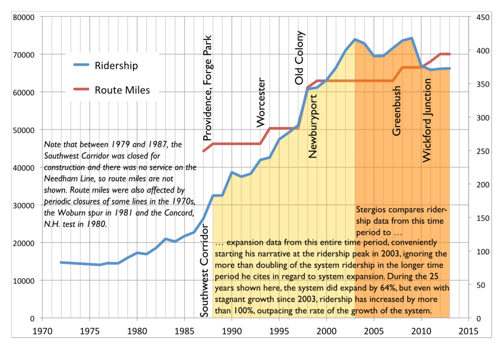
(Vertical lines show locations of system expansions.)

• Then there’s this:

Notwithstanding the fact that the MBTA added more commuter track miles than other major transit systems in the country over the past 25 years, quickly raised fares and continued substandard service led, remarkably, to a decline of 13 percent in commuter rail ridership from 2003 to 2013.

Can you spot the incongruity there? Stergios assails the T’s expansion over 25 years, but is only concerned about it’s ridership over 10. It turns out that before 2003, the T was the fastest-growing commuter rail system in the country. If you look at the period from 1988 to 2013, T commuter rail ridership more than doubled. Even if you exclude extensions, at stations open in 1988 and 2013, it grew 65%. I made the argument that T ridership is hampered by high fares, and stand by that conjecture. In fact, for trips between 18 and 27 miles, the T has the highest fares of any commuter rail system in the country (this will be explored in depth in a later post).

It’s almost as if the investment in commuter rail in the 1980s and 1990s paid dividends in ridership during that time. But for an institute that wants to cut investment in transit, those data are very inconvenient. So they choose to ignore them. Thus, his data are misleading at best, and borderline fraudulent at worst.

• So he’s stepped in it already, but then he links to an article from his policy “research” institute that allows him to step in it some more. That article goes to great lengths about how, between 2003 and 2013, the T was the only major commuter rail system to lose ridership. You know what, I can’t argue with that. During that time period, the T did lose ridership, while other agencies gained. Again, I contend that it’s due to fare policy, but we each have our ideas why. But notice how he again very conveniently picks 2003 as his start date, which was the highest ridership on record. By doing so without showing any other data, he suggests that the T has underperformed other commuter rail networks. Let’s see if that is actually the case.
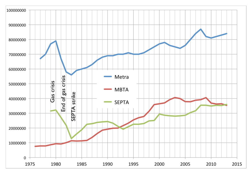
Annual ridership for SEPTA, Metra, MBTA

The two most similar commuter rail networks—with multiple legacy lines feeding the city center—are SEPTA in Philadelphia and Metra in Chicago. They also (conveniently for me, this time) have ridership data back as far as 1980. (Here’s SEPTA, here’s Metra, which I estimated from a chart but is exact enough for this post. Unlike Pioneer I don’t obscure my data sources; all MBTA data came from the Blue Books available on the T’s web site.) And, yes, the MBTA has had stagnant ridership in recent years, while SEPTA and Metra have both trended upwards. (This is also the case with New York’s commuter railroads, as well as Caltrain and MARC.) So there is certainly a case to be made that the MBTA’s commuter rail networks has been a laggard in recent years. This is likely due to a variety of factors, including stagnant service levels (SEPTA has, in recent years, been adding service), increasing fares (both Metra and SEPTA have lower fares per mile) and equipment and trackage which has been allowed to fall in to disrepair (SEPTA has invested heavily in their physical plant recently, and Metra runs on freight lines which have kept their tracks in good working order).

But the chart above is only one way to look at these data. Another is to normalize everything by an arbitrary year. I used 1988 (left), because Stergios likes to look back that far (sometimes). But for fun, I also made a chart that goes back to 1979 (right), because that’s the first year I have data from for all three systems.

Feel free to click to enlarge. The 1988 chart shows how, in the past 25 years, ridership on the MBTA Commuter Rail system has far outpaced SEPTA or Metra, growing by more than double while the others grew at a much slower rate. Go back to 1979, and the T has more than quadrupled, while, after falling off in the early 1980s, Metra and SEPTA only recently surpassed gas crisis ridership levels. In fact, if you look back to most any year but 2003, you get a very different picture. But, again, Pioneer’s “research” is picking and choosing numbers to fit their narrative, but not to show what actually happened.

• But wait, there’s more. He also claims that the MBTA has added more commuter track than any other system in the country in the past 25 years. Here he’s not fudging numbers, he’s just plain wrong. The T operates 394 miles of commuter rail. Metrolink, in Los Angeles, operates 388 miles. However, Metrolink began operation in 1992 which—let me get out my abacus, carry the 2—is only 23 years ago. So in the past 23 years they’ve added 388 miles. I’m not sure to the decimal of the amount the T has added (it’s about 145 miles over that time, of which at least 20 is in, and paid for by, Rhode Island) but it is certainly less than 388; even in 1988 the T operated more than, say, a shuttle from North Station to West Medford.

• Stergios also references his bus maintenance study, but that study borderlines on laughable, and may also be the subject of a separate post. Of several data irregularities there, the most glaring are the comparisons that the Pioneer Institute draws from the most comparable bus systems. For example, the list of most comparable bus systems to the T’s includes many systems in warm climates with low living expenses and ridership 1/10th of the T. Are we surprised that the transit authority in El Paso or San Bernardino has lower costs?

They make a major comparison to MetroTransit in the Twin Cities, an agency that also maintains buses in a colder climate. But nowhere in the report do the point out that while they have the same number of buses, the T carries twice as many passengers, and therefore, twice as many passengers per bus. This means that the T runs many more buses at or over capacity. A bus crammed with 75 passengers on board carries about 30% of its total weight in passengers, putting much more stress on not just the motor, but the air bags, axles, struts, tires and other equipment. (Imagine loading a Toyota Corolla with five 180 pound people and 500 pounds more in the trunk and a roof box. That’s what the T asks much of it’s fleet to do several times per day.) Many of the T’s bus routes run at this capacity on a daily basis. Only a few MetroTransit routes do, and often over longer distances. For instance, the MetroTransit Route 5 has comparable ridership to the T’s #1 bus, but its route is three times longer, meaning that the bus is not full nearly as often.

It is opaque as to how the Pioneer Institute chose other comparable agencies, but they often talk about the 79 other “large” agencies. However, the T is one of the top 10 agencies, and comparing it to an agency with as many passengers a day in total as the #1, #39 and #66 buses carry makes no sense. Is there a correlation between bus maintenance costs and overall ridership? They don’t bother to find out, and continue with these false, apples-to-oranges comparisons. The only comparable agencies in their database of the 20 most-similar systems are WMATA in DC and Muni in San Francisco (and even this is not apples-to-apples; WMATA carries fewer passengers per bus while San Francisco has no winter weather). Those agencies’ costs perfectly bracket the T’s maintenance costs per mile: the T is $3.80, WMATA is $3.20 and Muni $4.40. Compared to those agencies, the T is about where it should be.

Stergios claims that if the T operated with the efficiency of the average of these “comparable agencies” it would save $40 million a year or more. But if it operated with the efficiency of the agency in San Francisco? The T would actually spend more money. This whole study comes apart if you pull any one of many loose threads. That it is even in the discussion shows how picking only very particular data can make pretty much any point. What’s sad is that the legislature and governor bought it hook, line and sinker.

• There’s the stuff that’s just plain wrong. He claims that:

MBTA Board of Directors inexplicably authorized $47 million to purchase the Pittsfield-to-Connecticut Housatonic line

Really? The T is buying rail lines in Berkshire County? That sounds a lot like a MassDOT project, and indeed it is. They’re related, certainly, but that’s not money coming from the T’s pot. This is just careless.

WGBH fancies itself a news organization, and, as such, should have a fact checking department. Most of Stergios’s article does not pass even the slightest sniff test. GBH should be ashamed for publishing this article full of half truths at best, and several outright lies. As for Stergios and the Pioneer Institute? Anything that comes from them is immediately suspect, and usually, when examined, mostly false. They should crawl back in to their hole until they can present data with a straight face.

Bus Lanes on the Harvard Bridge

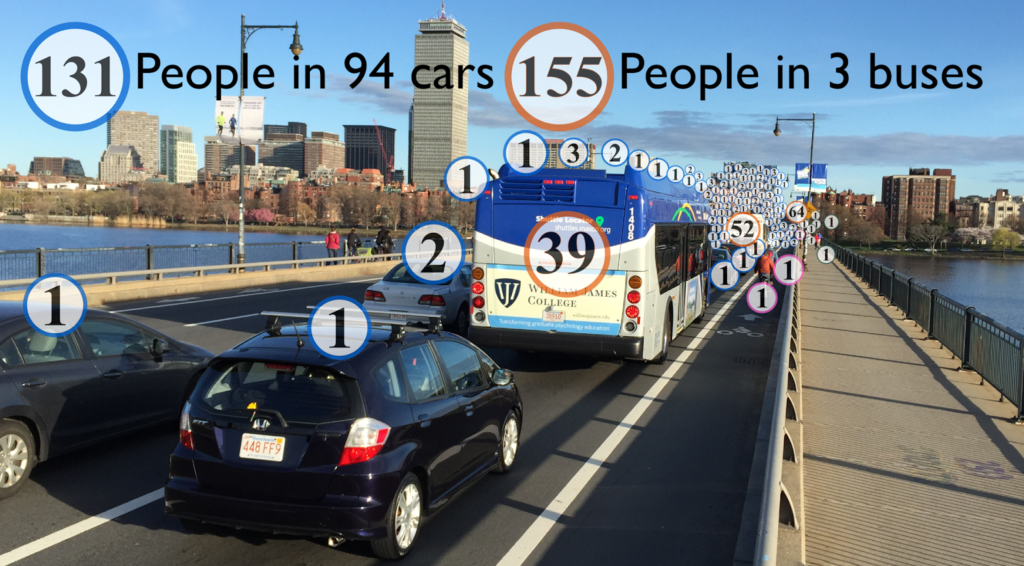
April was Bus Month here at Amateur Planner, and May is showing no signs of slowing down. I noticed recently that in a traffic jam on the Harvard Bridge (which occur regularly, especially during baseball season), there are not many buses on the bridge, but they carry a large portion of the people crossing it. So I waited for the next traffic jam on the bridge (not a long wait) and went to take a photograph, which I then annotated:

This was taken at the 250 Smoot marker (so about two thirds of the way to hell), and I noted that, in stopped traffic, there were 20 cars per 100 Smoots (this is a bit more than 25 feet per car; Smoot markers make it really easy to quickly measure things). I took a quick census of the number of people in each car (appeared to be about 1.3) and set about making the graphic above. (The bus numbers account for one at all-seated capacity, one at normal standing capacity, and one at crush load.)
Then I tweeted it, and it may have gotten retweeted a couple of times.
There was one bizarre (in my opinion—and I’m really not sure if it’s uninformed or malicious) response thread, which amounted to the following (as requested by the Tweeter, the full conversation is below):
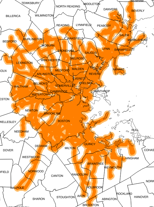
This is where the bus does go. (1/4 and
1/2 mile buffers of MBTA bus routes.)
So, pretty much everywhere.

Responder: Plenty of people need to get where buses don’t go.
Me: I’m fine with them having one lane of the Harvard Bridge, and the buses go a *lot* of places; if they ran faster than cars, more people would take them.
Responder: So glad you’re not making the rules.
Me: Here are areas within 1/4 and 1/2 miles of bus routes, where again are people going that the buses don’t go? [See map at right.] And why should my tax $$ go to pay for buses to sit in traffic so cars can … sit in traffic? >50% of the people on the bridge are in buses. Why not give them 50% of the space?
Responder: It’s the when, not the where. Bus schedules don’t nec. match ppl’s schedules. RedSox fans all over NE. [editor’s note: see original Tweet in thread.]
Me: So if the buses were 15 minutes faster than driving, people would take them, and anyone who *drives* to Fenway deserves a dope slap. [There’s] plenty of parking at Alewife-Riverside-Wellington-Wonderland. Trains run every 5 mins. Why should 20k+ bus passengers be delayed 10 mins for a few Sox fans?
Responder: It’s about making connections too—when too many connections get inefficient, driving works.
Me: Driving works? Tell that to the people on that bridge: people were walking faster. Bus lanes means more people opt for transit, fewer cars overall, and less traffic.
Responder: Just because buses work for you doesn’t mean they work for all.
Me: That’s the problem. They don’t work. The deck is stacked in favor of driving. I’m not saying ban cars, I’m saying let’s equalize street real estate. Why shouldn’t a bus with 50 passengers have priority over a car with 1 or 2?

But this is the usual reactionary inability to see the greater good. Take away a lane from cars, and it’s an affront to driving. An affront to freedom. Un-American. Never mind the majority of people on that bridge aren’t driving cars. They don’t matter. Still, I haven’t heard this turned in to an equity argument, so that’s kind of groundbreaking.

So the first part of this blog post is a plea: Ms. Cahill, I want to know what goes through the mind of someone who can’t see that transit efficiency is a societal benefit, and that it will amount to more people using fewer vehicles. Please email me, comment here, and discuss. I want to know.

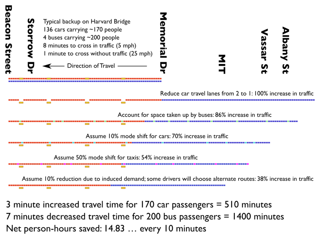
The second part is me, trying to quantify what would happen to vehicles displaced by a bus lane on the Harvard Bridge, and what the time savings would be for bus riders as opposed to the time penalties for drivers. And, as I am wont to do, I did this in chart form. I imagined a hypothetical traffic jam stretching across the bridge (0.4 miles) in a closed system where all of the cars feed off of Mass Ave on to the bridge (this is close to the case, but some traffic does enter from Memorial Drive):

At first glance, going from two lanes to one would double the length of roadway needed to store the same amount of cars. But several other factors come in to play. First of all, the buses take up the space of 8 cars—at least. Then, we can assume that 10% of the cars remaining will shift modes: if taking the bus is all of the sudden significantly faster than driving, people will use it. And people in taxis (by my estimation, 10% of the traffic on the bridge) will likely switch in greater numbers since they’re starting closer by: I estimated 50% mode switch there. Then there’s induced demand: make the traffic on Mass Ave worse, and some drivers—I said 10%—will choose another route, whether it’s the Longfellow or the BU Bridge or further afield.

Add these together, and I would guess that traffic would increase by between 1/3 and 1/2. Assuming that traffic moves at 5 mph, this would mean an increase of 2.5 to 4 minutes for each person in a car on the bridge. But it would also mean that buses would cross unencumbered by traffic, making the trip in one minute, and saving every bus passenger 7 (this assumes that the bus lanes extend back to Vassar Street, displacing bus stops and a few parking spaces on Mass Ave through MIT). With these numbers, drivers would incur 510 minutes of additional delay, but bus passengers would save nearly three times that much time—a dramatic benefit.

Am I way off base with these numbers? I don’t think so. When the Longfellow went from two lanes to one, vehicle traffic decreased by nearly half! Traffic spread to other locations, people chose other modes (walking, biking, transit), or didn’t make trips. The traffic apocalypse that was predicted didn’t materialize, and life has gone on.

The Harvard Bridge is one of the most heavily-traveled bus corridors in the city, up there with the North Washington Bridge, the Silver Line on Washington Street, the 39/66 concurrency on South Huntington, portions of Blue Hill Avenue, some streets to Dudley and the feeder buses to Forest Hills. (All of these should have bus lanes, by the way.) The 1 and CT1 combine for more than 15,000 trips per day and, at rush hour, better than one bus every 6 minutes. The bridge also carries the heavily-traveled M2 MASCO shuttle 6 times per hour. Combined, these routes account for a full (usually crush-load) bus every three minutes—which is why in a 10 or 12 minute traffic jam there are three or four buses on the bridge at any given time—transporting at least 1000 passengers per hour.

Bus lanes would allow these bus lines to operate more reliably, more efficiently and more quickly, meaning the same number of buses could run more trips, and carry more people. Which, if they’re 10 minutes faster than cars, they’re going to be carrying! This would be something that could be tested and quantified, and it could be done as a temporary pilot with cones and paint. There is no parking to worry about, no bus stops to relocate: just set aside one lane for buses (and give buses signal priority at either end of the bridge). This would take the cooperation of MassDOT, DCR, Boston and Cambridge—and prioritize “those people” riding transit over real, taxpaying non-socialist Americans—so I don’t expect it to happen any time soon.

Going in circles on the Silver Line. Or, how the T could save $1m tomorrow.

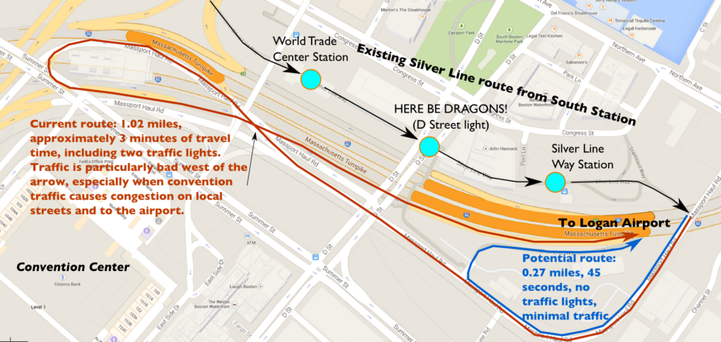
In my last post on the Silver Line, I wrote about how the poorly-timed light at D Street causes unnecessary delays. If you’re lucky enough to get across D Street, you then go through the power change at Silver Line Way and then begin the loop back to get on to the Ted Williams Tunnel to the airport (and soon, Chelsea). The end of Silver Line way sits right above the tunnel portal. But to get to that point requires a roundabout route, often in heavy traffic, which takes a full mile to return you right to where you started.

If only there were a better way.

There is.

After leaving the busway, the Silver Line outbound route goes down the Haul Road, merges in to a ramp from the Convention Center and D Street, and runs fully half the distance back to South Station—in mixed traffic—before finally turning on to the Turnpike towards the tunnel and the airport. What’s the point of building a bus rapid transit corridor if you then spend the same distance sitting in traffic to get back to where you started?

What’s worse, the “Bus Rapid Transit” endures two traffic lights in mixed traffic, and this traffic is often heavy, especially when when convention traffic from the nearby convention center spills on to the highway at already heavily traveled times of day. The route is more than a mile long, and in perfect conditions takes 3 or 4 minutes, but in heavy traffic can easily take 10 or 15; this traffic especially renders the “rapid” part of BRT useless.

Before entering this morass, there is access to the tunnel via a ramp next to a state police facility. If the buses could use this ramp, they would save three quarters of a mile of travel, two traffic lights, a yield at a merge and, conservatively, two minutes per trip. Combined with the potential savings at the D Street light, these two improvements could save 10% of the total round trip time between South Station and Logan—or Chelsea.

Now, perhaps there’s a technical reason the Silver Line buses couldn’t use the ramp. Maybe it was too steep for the buses. But in 2006, when part of the tunnel collapsed, the T was granted permission to use the “emergency” ramp to access the tunnel beyond the panel collapse. A Globe editorial from that summer praised the T for its quick thinking in utilizing this routing. Yet when the tunnel panels were fixed, the buses were rerouted to the roundabout course which brings them halfway back to South Station before they enter the tunnel.

MassDOT actually has these buttons.
Time to put them in to action.

There’s obviously no physical reason this ramp can’t be used, since it was used in the past. And any argument that the merge wouldn’t be long enough to be safe is unconvincing, especially since it would only be used by a bus every four or five minutes, even when the Gateway project to Chelsea is completed. The in-tunnel merge has 1/10 of a mile before the lane ends, far longer than similar merges on to the Turnpike in the Prudential Tunnel. Suggestions that this would be unsafe are protective hokum; with appropriate merge signage (perhaps even a “bus merging when flashing” light) there should be no reason why this can’t take place safely. The Transportation Department, MBTA and State Police need to convene to figure out the best way to use this facility, but the answer certainly should not be the usual “no,” or “but we’ve always done it that way.”

There’s an environmental justice piece, too, especially with the extension to Chelsea, a disadvantaged city a stone’s throw from Downtown Boston, but a slow ride away by transit. Right now, Chelsea residents are at the whim of the 111 bus—and the traffic on the Tobin Bridge. It seems foolish to build a brand new bus line to Chelsea but not to address one of the major bottlenecks on the rest of the route. If the Governor is serious about implementing reforms to improve service and save money, he should look beyond specious claims of sick time abuse and at where interagency cooperation could save time for passengers and time and money for transit operations.

Dr. Evil. Transit economist.

It costs the T $162 to operate a bus for an hour. The SL1 Airport service operates 128 trips per day, and we can reasonably expect that the Chelsea service will operate with a similar frequency. Fixing the D Street light and using this ramp could conservatively save 4 minutes for each of these 256 trips, which would equate to an operational savings of $1,000,000 per year.

Is this a drop in the bucket as far as the T’s overall revenue is concerned? Sure, it’s less than one tenth of one percent. However, it’s a million dollars that could be saved, pretty much overnight, with basically no overhead investment. We spent more than half a billion dollars building the Silver Line tunnel and stations, and acquiring the buses. And the SL1 buses actually turn a (slight) operational profit! It’s high time we removed some of the stumbling blocks it’s saddled with and let it operate with a modicum of efficiency.

#FixTheSilverLine

Where could the MBTA implement unscheduled short turns?

I recently wrote about short turning a bus on the EZRide Shuttle route. People will ask: “why doesn’t the T do this, my bus is always bunched?!” The answer is a) it’s not easy to do, b) they are way too understaffed to do so, and c) their schedules are so much more complex that there are many more moving parts. At rush hours, the T has four dispatchers watching 100 buses; my office has one or two watching nine (although it’s not our only job, sometimes it demands full attention). The need for short turns arises at times when there is heavy traffic and ridership. At those times, it’s all the dispatchers can do at that time to keep some semblance of order among the 250 buses they’re watching, not turn their attention to one particular part of one single route.

And also: there are only so many places and times you can successfully execute a short turn. Our route has a lot of twists and turns which make it easy for a bus to take a right instead of a left and go from outbound to inbound, but often a short turn may require a bus to go around a narrow block in traffic, and you certainly don’t want a bus getting stuck on a narrow corner where it doesn’t belong. There are more issues with the T: we know our drivers are on one route and that their shifts end around the same time. I’ve actually had times where a driver couldn’t cover an extra run because he or she had to be at another job; this is more frequent at the T where shifts start and end in a very complex scheme and at all hours of the day; a driver might finish one trip and set out on a different route, so a short turn would find them far away from where they needed to be. And finally, the T has thousands of drivers, so there is no way for a dispatcher to know whether a driver is familiar with the route and where to make a turn, or whether it’s his first day in the district and he or she is following the route for the first time.

Trains? Buses are much easier than trains. Trains require operators to change ends, change tracks—often at unpowered switches—and obtain a ton of clearance to do so, especially on the older sections of the MBTA system which don’t have the kind of new bi-directional signaling systems that, say, the DC Metro has. If the T had pocket tracks in the right places, it might be easier. But without them short turns would only save time in a few circumstances and a few areas.

And on a train you’re dealing with even more passengers. I’ve been on trains expressed from Newton Highlands to Riverside. Even with half a dozen announcements, a couple of stray passengers won’t pay attention (buried in their phone, perhaps) and then wonder why the train is speeding past Waban. I’ve heard of crews at Brigham Circle, after switch the train from one side to the other, walking through the car rousing passengers who are on another planet (or just staring at their phones). If you can’t run a short turn expediently, it’s not worth doing at all.

That being said, I have a couple of thoughts on routes which could benefit from more active management and, perhaps, some short turns. Both are frequent “key” routes, both experience frequent bunching, and both carry their heaviest loads in the middle of the routes, so that the passengers from a mostly empty bus in the trailing half of a pair could be transferred forwards without overcrowding the first bus. The are (drumroll please): the 1 and the 39. Let’s take a quick look:

Actual NextBus screen shot for the 1 bus.

1. The 1 Bus is one of the busiest routes in the system (combined with the CT1, the Mass Ave corridor has more riders than any other such route except the Washington Street Silver Line) and frequent headways of 8 minutes at rush hours. There is no peak direction for the route; it can be full at pretty much any time in any direction. And it is hopelessly impacted by crowding and traffic, such that bunching is almost normal, and on a bad day, three or even four 1 buses can come by in a row, with a subsequent service gap. (It could benefit, you know, from bus lanes and off-board fare collection, but those are beyond the purview of this post.)

But the 1 has a couple of features that make it a candidate for short turning. First of all, its highest ridership is in the middle of the route. The route runs from Dudley to Harvard, but the busiest section is between Boston Medical Center and Central Square. Going outbound (towards Harvard) many passengers get off at Central to transfer to the Red Line or other buses, inbound (towards Dudley), many passengers get off at Huntington Avenue and the Orange Line to make transfers. So here’s a relatively frequent scenario:

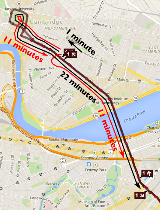
The black lines show the actual headways. The red
shows what could be accomplished by short-turning
one of the bunched buses at Central Square.

An outbound 1 bus gets slightly off headway, encounters heavy crowds, is filled up, and runs a few minutes behind schedule. Meanwhile, the bus behind encounters fewer passengers, spends less dwell time at stops, and catches the first bus. The first bus may have 60 passengers on board and the second 30. The buses remain full past MIT and pull in together to the stop at Central Square, where two thirds of the passengers disembark (and few get on: it’s faster to the the Red Line to Harvard or beyond). So now, the first bus has 20 passengers on board, and the second 10. In the mean time, since the first bus is behind schedule, there is now a 20 minute service gap: the first bus should have looped through Harvard by now, and if the buses proceed as a pair, the first bus will pull right through the loop and head out late and with a heavy load, and even if the second bus has a few minutes of recovery, it will quickly catch the first, and the process will repeat inbound.

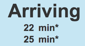
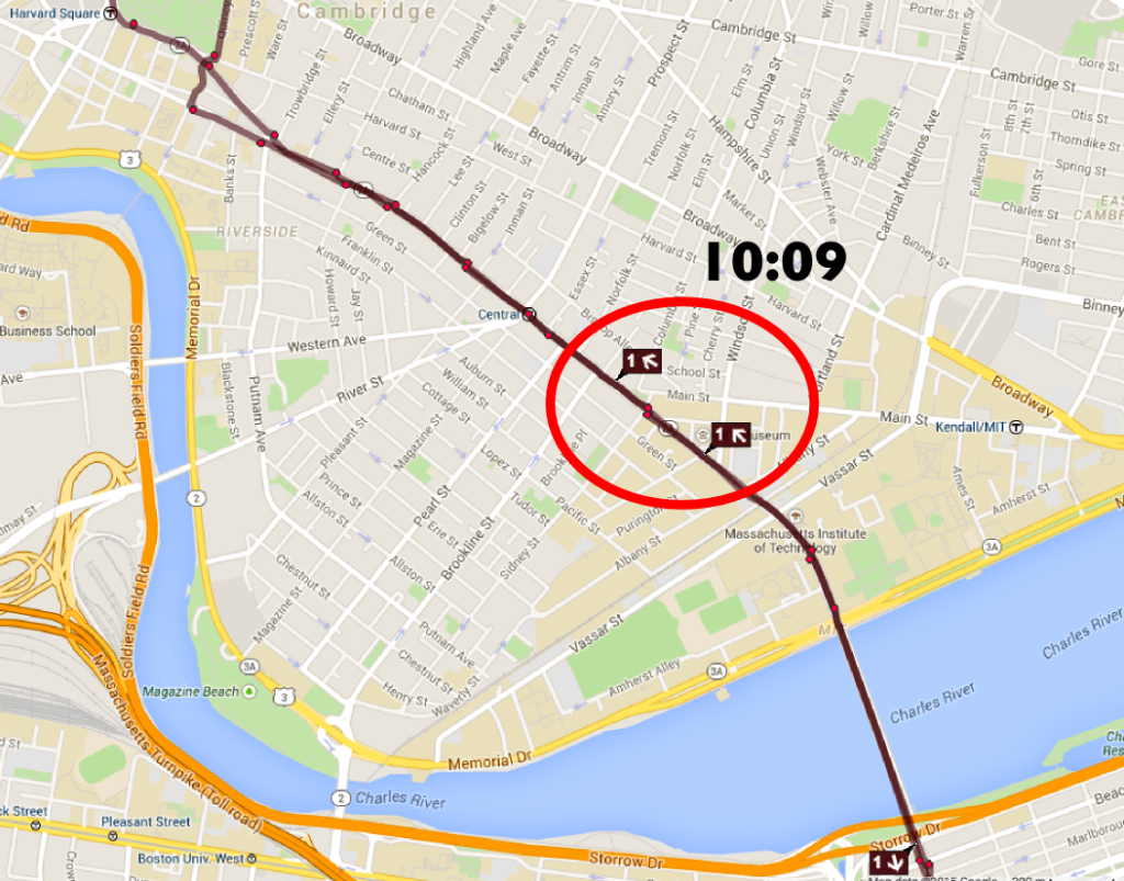
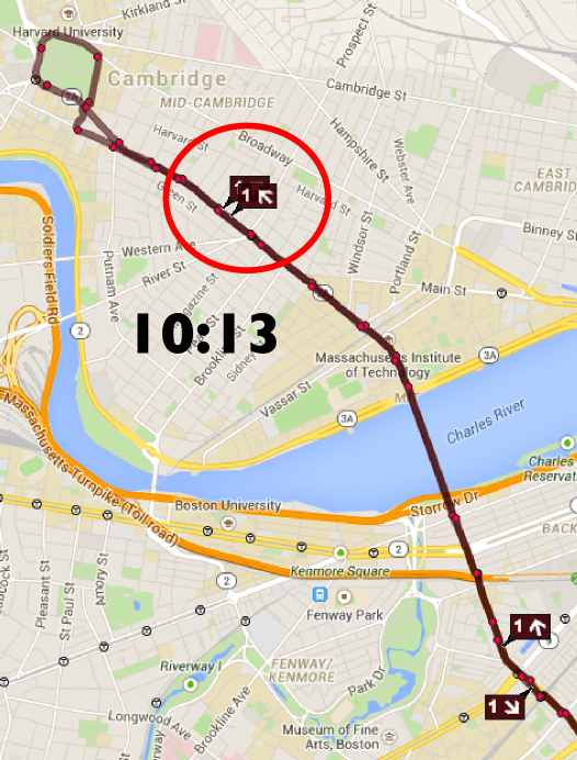
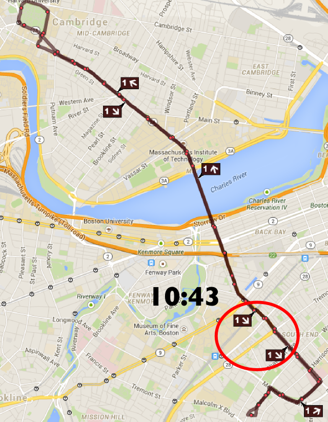
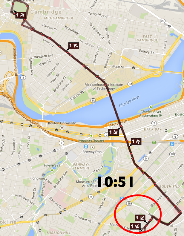
You won’t be shocked by this, but I went to Nextbus, pulled up the map for the 1 bus, and at 10:15 p.m. on a weeknight, found this exact scenario. See the map to the right. The first bus has gotten bogged down with heavy loads, so there is a 22 minute gap in front of it, while there is another bus right behind. The bus in front should be going inbound at Central right now, but instead both will continue to Harvard, loop around, and start the route bunched: the second bus will lay over for about three minutes and, most likely, after passing several vacant stops, be right on the tail of the first.

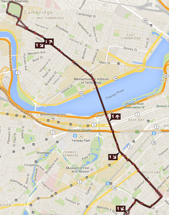
This is what the 1 bus route should look like
without any bunching. This is somewhat rare.

And the loop is a particular problem since there is not time or space there for the route to have recovery time, so if a pair of buses enters bunched, they are likely to leave bunched as well. Instead of having proper recovery time at each end, only Dudley serves to even out headways. So bunches are much more likely on the inbound (Harvard-Dudley) having occurred going outbound. And given the traffic, passenger volume and number of lights on this route, bus bunching is likely.

But what if, magically, that bus could be going inbound? Well, it could, and it wouldn’t be magic. It would be a short turn. If a dispatcher were paying special attention to the route, the operators could consolidate all passengers on to one bus in Central Square. At this point, the empty bus could loop around and resume the trip inbound from Central (even waiting in the layover area for a minute or two if need be to maintain even headways), where the bulk of the passengers will be waiting. The bus with passengers will continue to Harvard. On the subsequent trip, every passenger’s experience will be improved. Anyone waiting for a bus inbound from Central will have service 10 minutes earlier—on a proper headway. And passengers between Harvard and Central will have a bus show up when it would have, except instead of quickly filling up as it reaches stops which have had no service for 22 minutes and subsequently slowing down, it will operate as scheduled.

Note that one bus is catching the other. This is the start
of the bunch. 10:09 PM. It’s not too late to short turn!

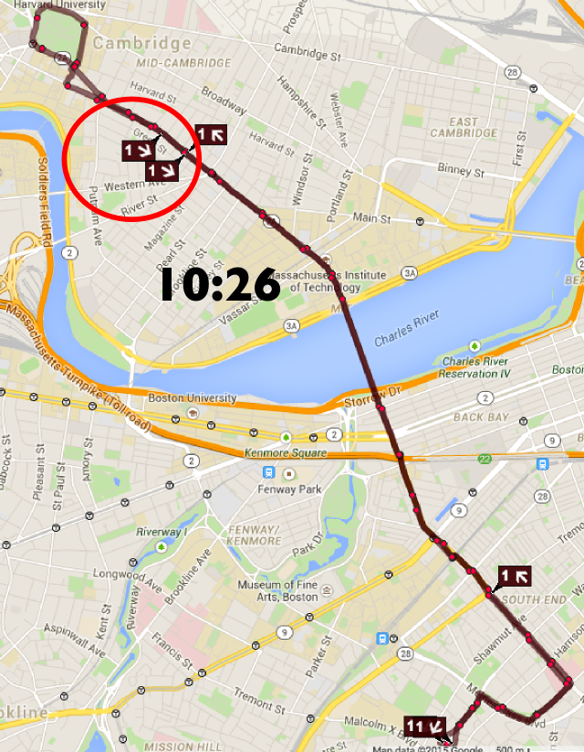
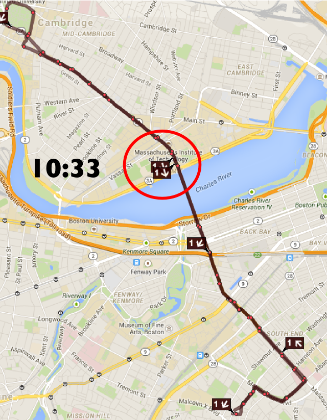
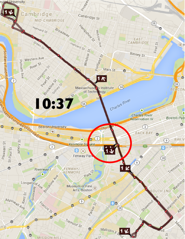
I watched the route for a while longer, and as predicted, the pair of buses looped through Harvard together, and then traversed the entire inbound route back-to-back, meaning that everyone there waited ten extra minutes, only to have two buses show up together. Every inbound passenger experienced the wonders of a 22 minute headway when the route is scheduled for 12. However, with one dispatch call and a transfer of a few passengers in Central, the headways could have been normalized, and the route could have been kept in order. An issue which was apparent at 10:09 (see the screen capture to the right) could have been fixed at 10:15; instead it lasted until nearly 11:00 (see below):

Now, is this easy? Hell, no, it’s not easy. First of all, the drivers have to know that it might happen. Then, they have to be able to clearly communicate it to the passengers. (If you focused on a couple of routes, you could have Frank Ogelsby, Jr. record some nice announcements. Imagine that deep baritone saying “In order to maintain even schedules, this bus is being taken out of service. Please exit here and board the next bus directly behind.” Oh, and of course, “we apologize for any inconvenience this may have caused.”) You’d have to be damn sure that there was another bus behind and its driver was instructed to pick up the waiting passengers. And a thank you Tweet (@MBTA: Thank you to the passengers of the 1 bus who switched buses so we could fill a service gap at Central) would be in order.

Would it be perfect? No. Sometimes you’d have an issue with a passenger who didn’t want to get kicked off the bus. If a bus had a disabled passenger on board, the driver could veto the short turn based on that fact, since the time and effort to raise and lower the lifts would eat in to the time saved by the turn. But most of the time, if executed well, the short turn would save time, money, and create better service for most every rider.


39. The 39 bus is similar. It is heavily used, and it bunches frequently. It also has its heaviest loads in the middle: the stretch between Back Bay Station and Copley is mostly a deadhead move, the bus only really fills up in the Longwood area, and the bus is mostly of empty of passengers along South Street from the Monument in JP to Forest Hills. So at either of these locations, a similar procedure could take place. If two buses were bunched going inbound, the first could drop off in Copley, take a right on to Clarendon, a right on to Saint James and begin the outbound route, rather than looping in to Back Bay and then out again to backtrack to Berkeley before beginning the route. Back Bay is necessary as a layover location when buses are on schedule, but there’s no reason to have a bus go through a convoluted loop when it could be short turned and fill a gap in service.

At the other end, two bunched buses could consolidate passengers on Centre Street in Jamaica Plain, at which point one could loop around the Monument (already the layover point for the 41) and begin a trip inbound, while the other would serve the rest of the route to Forest Hills.

So those are my two bus routes that could be short-turned and unbunched. Combined, they carry 28,000 passengers per day: the busiest routes in the system. I would propose a pilot study where the T figured out when these routes are most frequently bunched (they have these data) and then assign a dispatcher to watch only these two routes during these times and, when necessary, short-turn a bus to maintain headways, along with some driver training to ensure proper customer service and expedient routing. It could also record messages, put up some signs, and make sure to have some positive outreach to passengers. This could be done for a period of time, and the results analyzed to see the effect of actively dispatching such routes. If it were deemed a success—if there were fewer bunches and service gaps (data could show this)—the program could be expanded, and perhaps automated: any time buses were detected as being bunched, a dispatcher could be notified, and then make a decision on whether it would be appropriate to short-turn the bus, or not.

The passengers—well, we’d certainly appreciate it, too.

How much money could All Door Boarding save?

This is sort of a post-live blog from Transportation Camp NE. One of the first sessions was regarding all door boarding on the MBTA. There are a lot of ins and outs—notably, that you have to account for all scenarios where people could access the system, for example potentially without paying a fare (Silver Line airport) or having proof thereof (boarded with a friend who paid and parted ways)—but it was a good discussion, and something that is moving forwards, but needs to move faster. I pointed out that the discussion needs to not be pushed by the small minority who complains (loudly) about fare evasion, or really by fare evasion at all, but by vehicle speed and efficiency, since 95% or more of passengers already pay their fare: we need to improve service for the vast majority.


Often, when we talk about all door boarding, we talk about the real and potential time savings. Muni, in San Francisco, started experimenting with all door boarding, and it turned out it worked really well, and they went system-wide, and it has saved passengers time. According to their final report, it saves 1.5 seconds per passenger boarding or alighting, and speeds overall vehicle speed by 2%. 1.5 seconds does not seem like a large number, but it begins to get a lot bigger when aggregated over a large number of passengers.
SF Muni and the MBTA have a similar number of surface passengers: about 500,000. (The T has about 400,000 bus passengers and another 100,000 or so surface boardings of light rail; looking at only surface lines, the T and Muni are actually quite similar in terms of size.) So, if we can save 1.5 seconds per person—we’ll look only at boardings, since many trips either end at a terminal station where all doors are used or are surface Green Line boardings that end in a tunnel—we wind up with 750,000 seconds saved per day. This is, rounded down a bit, 200 hours saved. The cost of operating an MBTA bus is about $163 per hour, and for a light rail vehicle $250 per hour. Let’s assume that half of that is direct operating cost: operator wages and such. Assuming the lower bound, it would save $16,000 per day. Even if there were no savings on non-weekdays, in 250 weekdays it would equate to operational savings of $4 million
Savings add up, quick.
Let’s look at it a different way. A full, two-car Green Line train in the morning carries approximately 300 passengers. On the B or the D lines, the surface portion of the route takes 32 to 34 minutes to run at peak rush hour (according to the T’s scheduled time). Saving 1.5 seconds on each of these boardings, would equate to 450 seconds, or 7.5 minutes: more than a 20% savings for the above ground route. With the addition of signal priority on the B line, you could be looking at speeding the route by 30% or more—a game changer for one of the slowest—and most heavily-used—surface lines.
The transit planners will say “well, these savings will probably just be added in to headway recovery time.” First of all, if you actually do realize a 7 minute saving, you’re talking about an entire rush hour headway, so I doubt it will all disappear, unless you are going to be lining up multiple vehicles at rush hour. But second of all, if these wind up making headway recovery times much more even, that’s great. That means you’ll have the same capacity without having to dispatch a train as soon as it arrives, but rather on even headways. This is likely to reduce the number of vehicles that wind up bunching, overloading and slowing down.
But let’s run with the $4 million figure. There are, on buses and the Green Line, probably about 1500 doors that would need car readers. If a pole-mounted reader costs $4000, the system could be paid for in a year and a half. Or if the system were assumed to last five years, you’d have $20 million to put towards the cost of the readers ($6 million) and additional enforcement ($12 million, or $2.4 million per year).
Oh, and customers? They’d get a faster ride. It’s a win-win, for everyone. Except the few curmudgeons who are less concerned with how the vehicles run, and more about the anecdote about the person they once saw jump a fare gate.

Downtown Boston is Busmageddon? Really?!

Update: A shortened far less ad hominem version of this has been published in Commonwealth Magazine.

Every so often an article comes along which is so inane, so poorly researched and so utterly stupid that it requires a line-by-line refuting.

The article in question, which has a dateline of March 31 so I’m assuming it’s not an April Fools joke, is:

End downtown Boston’s busmageddon Add reworking bus routes to the MBTA’s to-do list

Oh boy.

The first four paragraphs go on about how people are taking public transit in Boston. Fine. Then you get to paragraph 5:

We need a comprehensive policy regarding usage of the public way. 

Good! We agree. We do need a comprehensive policy regarding usage of the public way. Right now, approximately 75% of the roadways in Downtown Boston are dedicated to automobiles. Another 20% are sidewalks, and 5% are bike lanes. Yet the number of cars is decreasing (to quote the author two paragraphs earlier), and the majority of people coming to Boston don’t use cars. So why do cars (as usual) get the vast majority of space? Why should they get all the real estate if they only account for a minority of travelers? Who knows.

Loading must be done during limited hours, as is the case in other great cities.

Loading? Fine. That’s a halfway-decent point. Care to elaborate? (Apparently not.)

To keep the city from devolving into perpetual gridlock, we also must address tour buses and MBTA buses downtown.

Boston has no through bus routes through downtown, the only city in the country to do so. Perpetual gridlock? How much of the gridlock downtown is caused by buses at Haymarket (in their own terminal, mind you), the Franklin-Federal loop, the Silver Line and a few other sundry routes, as opposed to, say, tens of thousands of cars trying to ply narrow streets downtown? Tour buses? Sure, get rid of those space-hogging menaces. But getting rid of a few MBTA buses? Please.

And what of these other great cities? What do they have in common? London? Bus lanes. New York City? Bus lanes. Minneapolis? Double bus lanes. Boston? Well, we have the Silver Line, but it barely has bus lanes downtown.

Let’s get the buses off of our streets so that pedestrians and bicyclists can be safe.

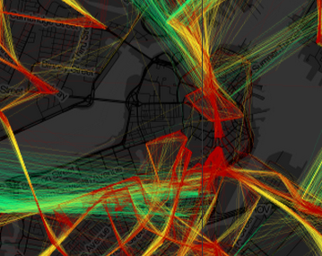
Red herring! Red herring! Red mfing herring! T Buses account for, oh, maybe 2% of traffic downtown. Maybe. Probably less. Certainly far less than any other city in America. Take a look at Bostonography’s great bus speed map (a screen capture to the right). Notice that there is actually a gap in Downtown Boston with no bus service. Compared to nearly any other city in the country, Boston has less bus service in its downtown. Other top bicycling cities like Minneapolis, Seattle, San Francisco and Portland have many more buses, yet no one is demanding that buses be pushed to the outskirts there.

Yet buses are menace to pedestrians and bicyclists? Should we consider doing something about the other 95% the traffic downtown? The cars? Or are pedestrians and cyclists somehow immune to them?

As Doug Most reminded us in The Race Underground, Boston constructed the first subway tunnel in the late 1890s to get trolleys off the street; we can certainly do likewise today by making good on the commitment to a tunnel connecting South Station with the Silver Line spur that heads to Dudley Square.

Oh, good lord. Yes, we could spend $2 billion to build the Silver Line Phase III tunnel. Somehow this would solve all of our transportation problems. Except for the buses going to Haymarket, South Station and all of the express buses. It wouldn’t really get any cars off the street (although by his logic, cars on the street aren’t the problem). It would create a low-capacity, slow route that could be replicated for 1/100th of the cost with signal priority and bus lanes. But that might impact cars and their drivers dense enough to think the best way to Downtown Boston is to drive.

There is also no reason why people wanting to go to Salem should have an express bus waiting for them around the corner from Macy’s …

Most people going to Salem don’t wait by Macy’s: they wait at the Haymarket bus station. (Also, if you’re actually from Boston, it’s Jordan Marsh. But I digress.) It’s not perfect, but it’s covered, and the buses pull in to a busway to load and discharge passengers. But so what if they do? Downtown Crossing is right in the center of the city. If we make people from Salem walk ten minutes, or squeeze on to an already-over capacity subway train, they’re more likely to say “the hell with it” and drive. Do cars cause congestion? Or just the 16 buses per day that run from Salem to Downtown Crossing?

… nor should city street patterns necessitate that a bus make a left turn from a right lane to meander through downtown streets to get to the Mass Pike.

The 500-series buses do load on narrow streets and have to reach the Mass Pike. Why? Because they are basically the replacement for the other two tracks of the Boston and Albany railroad. When the tracks were paved over for the Turnpike, the 500-series buses replaced local service there. There were proposals in the ’40s to run service similar to the Highland Branch from Park Street, out the Tremont Street portal, on to the tracks parallel to the current Worcester Line, and out to Allston, Brighton and Newton (huge file here). Instead, we had got the Turnpike, which express bus service, which is express until it sits in Turnpike traffic. If you hadn’t built the city for cars, you wouldn’t have to worry about the buses; the streetcars could be underground in that aforementioned tunnel.

Large buses making wide turns on narrow downtown streets, even more narrow because of mounds of snow, clog the streets and imperil the safety of the public. 

Large buses clog the streets? What about parked cars? What about moving cars in traffic? How about we eliminate downtown on-street parking and give the buses their own lanes, and make sure the mounds of snow are removed from them. And do only the buses imperil public safety? No pedestrian has ever been killed by a car, right?

We should eliminate bus lines which make no sense and relocate the terminus of lines now heading downtown to South Station and North Station …

We have an intercity bus terminal at South Station. It’s at capacity. There’s no way to add T buses in to it. And it’s a five minute walking transfer to the already-over capacity Red Line.  The current routes that could conceivably go to South Station aren’t perfect, but they seem to work. Maybe we should create a network of downtown bus lanes instead? Cyclists and pedestrians would know where the buses would be, and it would help buses move through downtown more quickly.

And North Station? That’s why we have the Haymarket bus station. It has room for buses and easy connections to the Orange and Green lines. Perhaps when the Government Center Garage is rebuilt, it will include a better bus terminal and connections, and bus lanes across the bridge to rebuilt bridge to Charlestown.

… where there is access to underground transit, commuter rail and the interstate highway system.

Yes, there is access to underground transit. That’s all well and good. Except that underground transit is growing faster than other parts of the system, while struggling with decades-old equipment and overcrowding. Most downtown buses operate like commuter rail: they go from the suburbs to the city. There’s little need for passengers to transfer to commuter rail, rather they want to transfer to their place of work. Instead of dropping people at the outskirts of downtown, we should have more central bus routes that balance operational efficiency with getting people where they want to go. Give as many people a one-seat ride and a comfortable place to wait, and they’ll be more likely to ride.

Even as we eagerly await the Red Sox return to Fenway Park, and the melting of the last mounds of snow (most likely in that order), we should be thinking – and planning – ahead.

If you really want to encourage safer streets, getting rid of transit is certainly not the way to go. Planning ahead will certainly be important, but let’s plan the right way. The right way might be a congestion charge, to get cars off the streets at peak times. The right way might be to build bus lanes so that bus riders have seamless trips through downtown to their destinations. The right way might be to require tour buses, an actual menace to pedestrians and cyclists which provide no actual public good, to stick to certain streets, routes and times.

Or the right way may be to raise the goddamn parking tax. Right now, Boston has one of the lower parking taxes around. Because parking is very much constrained, it is not subject to the whims of supply and demand: a daily tax on parking spaces would likely not even affect the consumer price much, but move some of the profit from the property owners to the city. Given the negative externalities of cars on city streets, and the fact that most people utilizing parking spaces are from out of town, the city should raise taxes and use the money to improve public transportation, perhaps starting with, that’s right, buses.

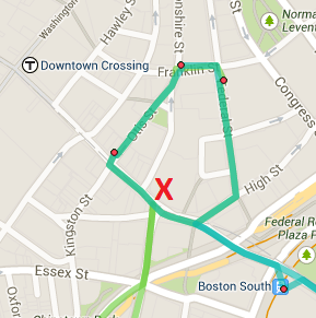
So the right way is not to demonize public transit and couch it in the guise of pedestrian and bicycle safety is disingenuous at best. Ignoring the fact that nearly all traffic downtown is made up of cars driving on subsidized roadways and offering debunked solutions is a farce. Note the red X on the map to the right. It shows the location of the author’s office in relation to the 448/449/459 and 500-series bus routes in Boston. What are the chances he’s just rubbed the wrong way by seeing a bunch of buses outside of his office? You know, buses that make it really convenient for people to get there?

Let’s build better bus facilities. Lincoln Street and the Surface Artery which all the 500-series routes follow have plenty of room for a bus lane (Lincoln Street has two lanes of traffic and two of parking). Federal has parking on both sides. Why not take some of that space which is making the streets narrow and dangerous and use it for buses? It might make it a little less convenient for Mr. DiCara to drive there. That’s probably his real beef.

And Commonwealth Magazine should be on the hook, both for not fact-checking this article, and for letting someone with no actual expertise in the industry write it in the first place. Just because he saw a lot of buses at Lincoln and Summer one morning doesn’t mean that they’re the problem. I wonder how he gets to work, anyway?

Mapping Gov on the T

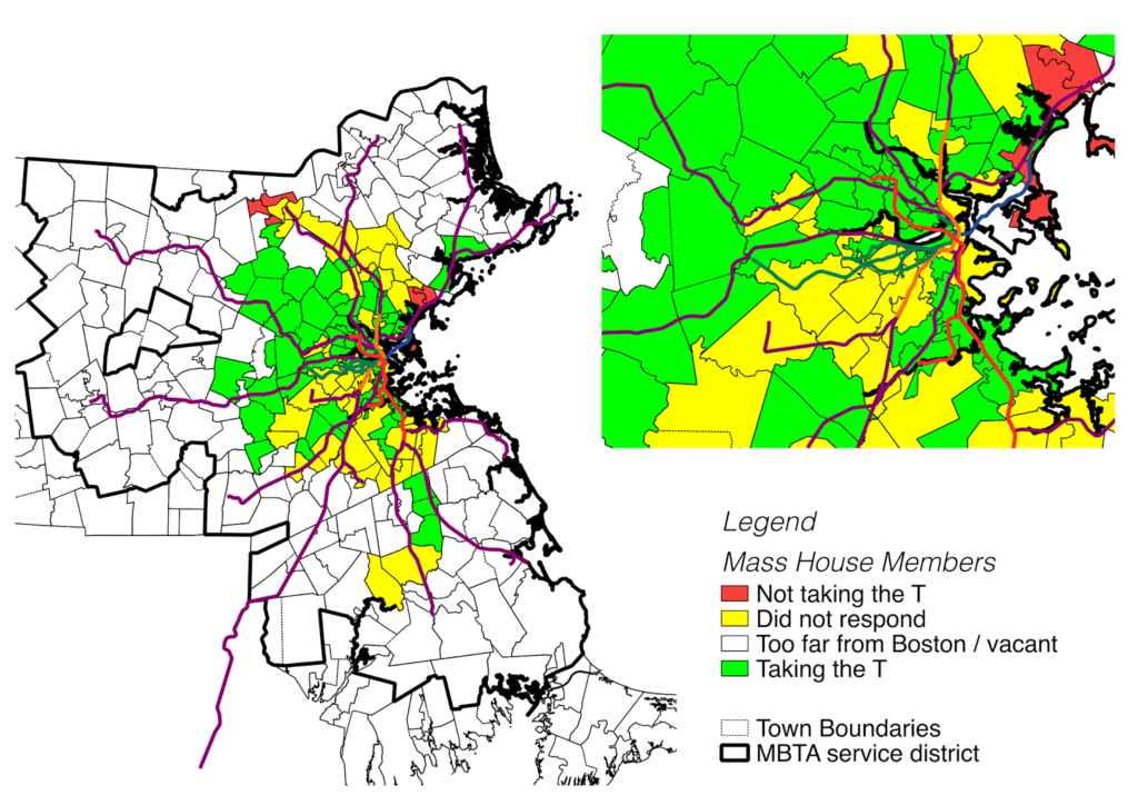
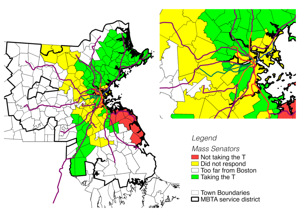
There’s a great grassroots group which is pushing for Massachusetts state legislators, who live within an hour (*) of the State House, to take the T to work on March 19, called Gov on the T. They have a list of members of the General Court, and have asked for commitments as to whether the will take the T to work. I decided that this begged to be mapped, so I did.

First, a couple of words (and the asterisk above). I have no idea how they calculated an hour, but it doesn’t make much sense, and there’s a fragmented area that is represented by the officials they’ve asked. For instance, the representative from Billerica is not listed, but lawmakers from Lowell are. The Senator from Gloucester is on the list, but not the representative. The representative from Bridgewater is on the list, but the one from Hingham is not. I think it would make much more sense to apply this test to any Senator or Representative who serves constituents in a town within the MBTA’s service district, which I’ve outlined on my maps.

(GovOnTheT, if you are reading, this, I am happy to select these districts and give you a list.)

Anyway, here is a map of House members who have pledged to take the T:

And here is a map of the Senate:

I think this is great, and partially because it is very grassroots: it’s not being pushed by a lobbying group, but by a couple of people who are pissed off that their legislators all drive because they have free parking on Beacon Hill. I hope that Gov on the T becomes a regular happening, and that legislators are held accountable. Those who don’t take the T—and vote accordingly—ought to get primary challenges, especially in districts where many of their constituents depend on transit. Take a look at some of the districts where representatives aren’t taking the T. There’s Lynn, Revere, Winthrop and the South Shore. And districts where the representatives are MIA, for instance: much of Cambridge’s Senate representation and house members in Newton, Brookline and most of Boston. Let’s hold our representation accountable.

ONE NIGHT ONLY! The T will provide 24 hour service this Saturday

It’s kind of gimmicky, but this Saturday, the good ol’ MBTA will be pretty darned close providing 24 hour service on some routes. The reason? Well, to start, late night schedules, but mostly because it’s the beginning of daylight savings time. Here’s the alert from the T:

Saturday: Despite the start of Daylight Savings Time, the number of available Late Night trips will remain the same Sunday morning (March 8). Last trains will depart from downtown at 3:30 a.m. with outer connections following later.

At 2 a.m. on Saturday, the clocks will magically advance to 3 a.m. The MBTA services running will not magically disappear in to the ether, but the T will basically assume that the time change won’t take place until the end of service. So some of the latest-running trains and buses, which normally don’t finish their runs until about 3:00, will actually not reach their terminals until 4:00. Notably, the last 28 bus will reach Mattapan at 4:05 a.m., the last Mattapan trolley will arrive around the same time, and several other lines will operate until about then.

Most T service doesn’t begin until 6 a.m. on Sunday mornings, but a couple of lines, notably the aforementioned 28, operate early airport service. (There should be a discussion that better service should be provided to the airport, which has expensive and limited parking, many low-wage jobs, and many early shifts, and which is completely inaccessible from most of the city by walking or bicycling, because ocean.) So service at Mattapan this Saturday will include:

3:00: inbound 28 bus departs *
3:15: outbound 28 bus arrives
3:20: inbound 28 bus departs ‡
3:40: outbound 28 bus arrives
3:45: inbound 28 bus departs *
3:59: inbound 28 bus departs †
4:05: outbound 28 bus arrives
4:45: inbound 28 bus departs †

* Saturday late night service   † Sunday AM service   ‡ Trip scheduled on both Saturday late night service and sunday AM service (!)

Now, it’s worth noting that there is a service gap of nearly three hours in outbound service: the first outbound bus on Sunday isn’t scheduled to arrive in Mattapan until 6:40. But what I find most intriguing is the fact that for nearly an hour, the Saturday and Sunday service actually overlaps (on a normal weekend, the last outbound arrival comes in just 15 minutes before the first inbound departure). Most interesting: the 3:20 a.m. inbound trip can be found on both the Saturday schedule (the 2:20 inbound trip bumped an hour) and the Sunday schedule (the regular 3:20 departure). Will the T run two buses inbound from Mattapan simultaneously, one on a Saturday schedule and one on a Sunday? It’s almost worth venturing down to Mattapan to see.

These are strange times we live in indeed.

Go to public meetings

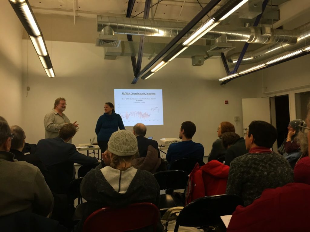
A chart that looks conspicuously like one which has
appeared on this page.

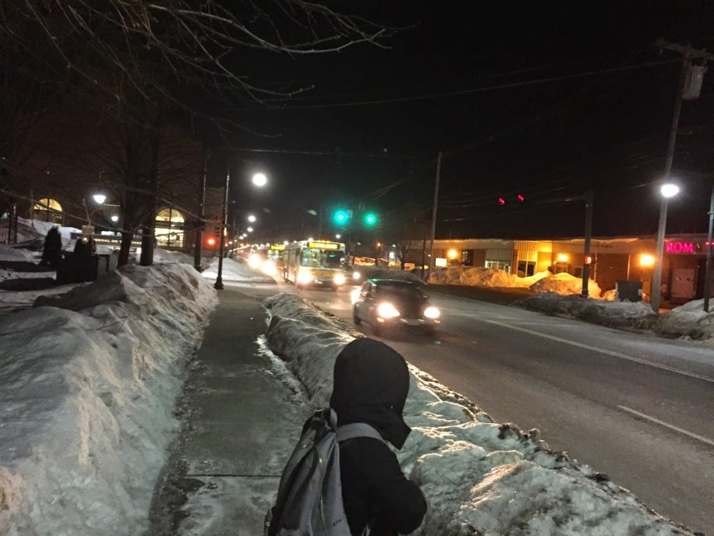
I went to a public meeting tonight regarding the 70 bus. I go to a decent number of public meetings, and this one piqued my interest because of my interest (and use) of the 70. So I trudged out in the 5˚ temperatures to Watertown to talk bus schedules.

So did a couple dozen other people. But, of course, they didn’t want to talk about the nitty gritty of bus schedules. They wanted to air their completely unrelated concerns. Melissa Dullea, who manages to not roll her eyes back when people yell at her about completely unrelated topics, was great, and the conversation was steered slightly in the direction that it needed to go. She also gave me a shout-out and used a modified version of my 70 bus post to illustrate the headway issue on the route.

But we also got to discuss such important items as:

  • Whether the T was going to eliminate stops at senior housing
  • How the straps on the buses aren’t low enough and that’s why there isn’t enough capacity
  • That people don’t move to the back of the bus and could drivers please make announcements more often (why people don’t take initiative and ask themselves is beyond me)
  • It would be great if there was a device that would tell you when the next bus was coming that didn’t require a smart phone. We have those. They’re called smart phones. (The best exchange was when one guy said “it would be a big seller” and someone else said “no, it wouldn’t.)
  • That those straps sometimes are missing completely and what can you do about it. (Why not tell the T the bus number.)
Just another day riding the 70. Or, as I like to call it, the 140.
What I’m trying to point out here is that if you don’t go to a public meeting, these people will. It’s not that their concerns aren’t valid, but they’re noisy, and completely uneducated. It’s kind of like NIMBYism: they care only about what directly affects them, with no concern for the greater good. And then when there’s actually an issue: a poorly-timed bus route, like the 70, they service planners will think that no one actually cares, because all they hear about are bus strap heights. I’m serious. Go to public meetings. 
There was a great presentation later about an app (busreport.com) which will allow people to report bus issues to a central database. Right now it is Watertown-specific, but I think it would be portable to the whole system. I love user-generated feedback like this. Now if there was only a device which would let you find out when your bus was coming that wasn’t a smart phone.
I left a few minutes early to catch the 70. And of course, two buses came at the same time.

Commuter Rail Ridership and Fares

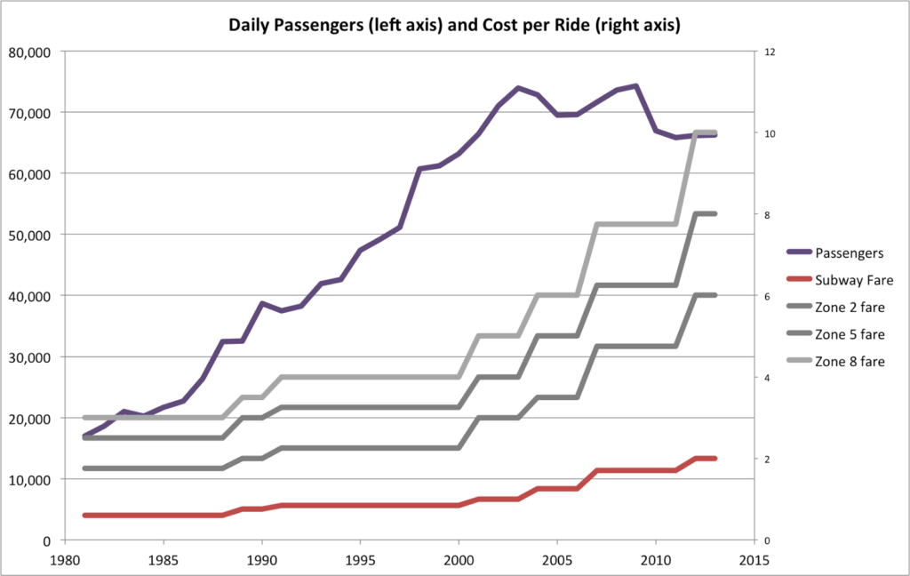
A Twitterer recently found a 1972 plan for transit-level service along many of Boston’s rail corridors and was floored that ridership on what we now know as Commuter Rail at that time was only 16,000 per day (it was 80,000 in the ’40s and now hovers around 70,000). It has indeed grown, especially the South Side lines: in 1972, only 600 people rode the Worcester Line daily (the then-speedy Mass Pike having recently opened); many single Worcester Line trains now carry that many; the line has grown more than 15-fold over the past 40 years.

But the time of impressive growth is even more impressive: in 1981, ridership on Commuter Rail still hovered around 17,000. And then it began to grow. By 1990, it had more than doubled. And during the 1990s, it more than doubled again, so that by 2000 there were more than four times as many riders as there had been two decades before. Some of this is attributable to extensions after service cuts in the ‘70s, and new service on the Old Colony Lines. But a lot is due to the revitalization of downtown Boston following the growth of the 128 corridor, worsening traffic, and higher parking costs.

For 22 years, from 1981 to 2003, Commuter Rail traffic grew every year but one: 1991, after the collapse of the “Massachusetts Miracle.” But it took off again thereafter, peaking at 74,000 daily riders in 2003.

It hasn’t been that high since.

At first, flat ridership could be blamed on the early-2000s recession. But in the past 15 years, ridership has stagnated. If ridership growth had continued, linearly, at the 1981-2003 rate, it would be poised to cross the 100,000 threshold this year. Instead, the numbers of riders has barely budged, fluctuating up and down as the economy, traffic, and the price of gas has ebbed and flowed, none of them seeming to dramatically affect ridership.

Except for fares. Take a look at the chart. It certainly seems that, once fares started to rise dramatically, ridership flattened out. In the last fifteen years, commuter rail fares have gone up 250%, while they didn’t rise that much in the 20 previous years (despite higher inflation). Subway fares have risen as well, but the nominal amount the fares have risen is very different.

In the ’80s and ’90s, a ride on the T cost 60 or 85 cents (that’s a token, by the way) while Commuter Rail fares ranged from $1.75 to $3, rising to $2.25 to $4. The ratios were similar to today (the highest Commuter Rail fare about five times a subway fare), but the difference only $3. Now? The difference between a tap of a Charlie Card and a punch of a ticket is $8, which is a much greater difference.

There are two salient bits here. First, subway ridership, despite the same relative rise in fares, has seen dramatic increase in passenger counts in recent years, despite the increases in fares. At issue here is the fact that Commuter Rail and urban rail are different populations: Commuter Rail passengers have more options. Most own cars. If the cost of driving and parking is not much more than commuter rail—and parking and driving costs haven’t more than doubled in the past 10 years—they are more likely to abandon the rails and head for the highways. If the MBTA provided excellent rail service, with fast speeds and reliability, this would be less of an push factor. But with old equipment and slow track, it is.

The second piece is that outside of peak travel times, the train generally can’t compete with vehicles on travel time, and on weekends, on ease or cost of parking. And while many trains at rush hour are near capacity, there is plenty of capacity on off-peak and weekend trains. It’s possible that if the T offered off-peak savings—say, $2 off all fares beyond zone 1A, or half off, or something—they could drive enough additional ridership to cover the lost fare revenue, all the while taking cars off the road, which is good for everyone. As would having sensible, clockface midday schedules. And it might even help ridership trends.

It’s rather obvious that Commuter Rail ridership is more elastic than subway ridership: when fares go up, ridership might not go down, but previous trends level off. Since urban riders would cry foul if local fares rose faster than Commuter Rail fares (the subsidy per ride is higher for Commuter Rail riders, although the subsidy per mile is about even), increasing Commuter Rail ridership would require better service. Given the recent performance of the Commuter Rail, this may be a tall order. But it should be a goal.