MBTA still won’t provide real all-night transit

The MBTA recently announced a pilot program to extend service hours on Friday and Saturday nights. This is a great step for the T, which hasn’t had subway service after midnight in over 50 years. While it does reduce the amount of time the T will have to inspect and fix its aging infrastructure, the other five nights will still have time for track work, while serving the busiest nights for late-night ridership. This is all good.

What Boston will still lack is an actual late-night transit system.

In every other major transit city in the country (More than 25% mode share: NY, Chicago, SF, DC, Philly or more than 1m daily ridership: LA), there is an option for getting around between midnight and 5 a.m. Not just on weekends. Not just until 3. (DC is a slight exception, some overnight bus routes shut down for 30 to 120 minutes around 3:00; but some routes, like the 70, have no more than an hour gap in service.) Service may only come every hour, and it may be a bus instead of a train, but if you need to get somewhere at 2 a.m., you might be able to take a bus there. This is not the case in Boston, and even with added Friday and Saturday night service, it still won’t be. Several smaller cities operate all-night transit systems as well.

Late night transit service is going to cost money, but depending on how it is structured it can serve two economic purposes:

  1. “Cosmetic” late-night service (such as what is being proposed by the T) makes Boston more competitive compared to other cities. Apparently, workers are more likely to want to live in Boston because if they work late on a Friday night and have a couple of drinks, they don’t have to worry about the train shutting down an hour before last call. (This Globe article makes that point.) By calling it “cosmetic” I don’t mean to make light of this, as moving Boston towards being more of a 24-hour city is a laudable goal, and pushing train service later on weekends is certainly a good move. DC operates similarly; the Metro there stays open until 3 on weekends while shutting down around midnight most nights, but they manage to run a few popular bus lines all night, or close to it. And, yes, the workers behind the nightlife will be able to finish their shifts and catch the last train instead of ponying up for a taxicab or driving.
  2. Full late-night service, however, serves a much wider economic purpose: it provides access to employment centers which would otherwise be inaccessible during certain hours. This page has argued this point in the past, making the case that the MBTA or Massport should fund and provide at least a low level of 24-hour service to the airport, where many shifts begin or end between midnight and 5 a.m. But there are other overnight workers too. Overnight service on major transit routes, even if it were only every hour, would provide job access, especially for low-income service workers who spend an inordinate portion of their income for driving and (at the airport especially) parking costs.
How does the rest of the country do it? Because I love charts, here are some charts. I’ll explain more below:

Obviously, New York skews this whole chart. It has more than four times the transit ridership of any other city, and 138 all-night routes (18 subway lines, the PATH, the Staten Island RR, 16 bus routes in Manhattan, 29 in Brooklyn, 47 in Queens, 17 in the Bronx and 8 on Staten Island). Let’s remove New York. Here’s the same chart, sorted by transit ridership, with the number of overnight routes highlighted:

Notice something conspicuously absent in the chart for Boston? It’s the only city with high transit ridership without overnight service. The next largest? Atlanta, which is not known for it’s transit friendliness (i.e. we’re not moving the Red Sox to Danvers) and has a third the daily ridership of the MBTA. And several smaller cities have pretty comprehensive late-night transit systems. Las Vegas makes sense; the city basically operates 24/7. And last call in Miami is 5 a.m. But Cleveland and Baltimore? They’re not what we think of as 24-hour cities. Yet they provide overnight transportation.

So the question is: is Boston going to put a cosmetic “hey look the trains run late filled with drunk people” band-aid on the situation? Or are we going to actually have a discussion of how to provide 24-hour transportation for citizens, and to jobs?
(There’s a longer history of cuts to overnight service. Many cities, including Boston, had owl service in the 40s and 50s. In quite a few cases it survived longer. For example, Portland Oregon cut overnight service in 1986, and Minneapolis had a more extensive network until 1998.)

(By the way, if anyone knows of any other cities with overnight service—other than Newark which runs the 62 all night to EWR, I know about it—let me know. I was surprised that I could find neither a list of transit agencies by overall ridership nor a list of cities with overnight bus service. If anyone wants to help fill out these lists, I’m all ears.)

The ignominious D Street light

Much has been written about Boston’s Silver Line (including on this page). It’s certainly not rapid, but it is rather convenient: I made it from Kendall Square to Terminal A in 25 minutes. The problem? It should have been 23.

I’ve noticed in the past that the Silver Line experiences long waits at the D Street grade crossing after it exits the tunnel. On my ride yesterday, I decided to find out just how long, by means of Youtube:

The bus gets to D Street, and proceeds to sit there for not 30 seconds, not a minute, but just shy of a minute and a half! This is a major service failure. The scheduled time from South Station to Logan airport and back is 45 minutes, meaning that if the bus loses 1:30 each time it crosses D Street, 7% of the route time is spent waiting for a traffic light. For the SL2 line, which is a 25 minute round trip, 3 minutes is 12% of the total operating time!

There’s this thing called “transit signal priority” which could be employed to eliminate these wait times. A sensor could be placed just outside the WTC station (and a similar one on the inbound run) which would be tripped when the bus passed by (there are already sensors which detect the bus and raise gates when the pass, and which close barriers should someone attempt to drive in to the tunnel). This would give 15 seconds to flash the don’t walk sign and change the light, allowing the bus to proceed through the intersection at full speed. Traffic would not be dramatically impacted since there light would only be red for a few seconds when the bus passes, and an algorithm could be put in to place to assure the green cycle for traffic was long enough to avoid backups (but not, you know, not 90 seconds when very few cars pass through; see above).

Transit signal priority (TSP) is not very expensive; even at the high bound it costs $35,000 per intersection. Ridership on the SL1 is, give or take, 8,000 per day. This means that in a year, for one penny per passenger, trip lengths could be reduced by more than a minute. This should be implemented immediately.


What’s more, this would result in reduced operation costs for the MBTA. Buses cost somewhere on the order of $100 per hour to operate. Even if the average time savings per bus was only 30 seconds, this would equate to 4.5 hours of operating time per day, or a $450 savings. Assuming a $35k cost for TSP implementation, it would pay for itself in 78 days—two and a half months.

The argument could be made that these times would just be built in to schedule padding at the end of the route and savings would only be from the reduced power use related to not stopping and starting. But, especially on the SL2, saving a couple of minutes could be used to decrease the overall route time and increase service, something the Seaport District desperately needs. At rush hour, decreasing the trip time from 25 to 23 minutes would allow headways to drop from 5:00 to 4:36—a capacity increase of 8%—without any additional cost. This would allow for 3 additional round trips at rush hour, or 75 additional minutes of service, which would save the T $125. By this metric, the payback would be $250 per weekday, and take 140 weekdays to pull in to the black. That’s 7 months. After that, it’s gravy.

(Another improvement: extending overhead wires along the whole of the SL2 route would allow the buses to operate without a change of power twice per trip; combined with the savings at Silver Line Way this might allow service to operate at 5 minute headways with 4 buses—a dramatic savings, albeit one with a higher initial capital cost.)

There is no logical reason that transit signal priority should not be immediately procured and installed at D Street. There is no need for a time-consuming review process; the benefits are clear and any disruption to traffic will be far less than the current disruption to the traveling public. While the Silver Line is still hobbled by a convoluted route system, low capacity, slow tunnel speeds, traffic and a poorly-designed power switch (often requiring the operator to exit the bus and manually raise the trolley poles), this inexpensive change would be a good start to dramatically improve service.

Station Name Creep

Jarrett Walker tweeted today about a piece he wrote a few years back on his blog regarding corporate naming for train stations. While I agree that it is a pretty dumb idea to have mindless corporate naming rights (“get on the train at Bank of America, change at Gillette and get off three stops later at Novartis”), station names in Boston have changed, rather drastically, over the years. Someone dropped in from 1950 would barely recognize station names today, even though the lines in the core of the city haven’t changed in the past 50 years. So, where appropriate, I think name changes are not the end of the world, and if they help direction finding without overly-lengthening the name, may help.

Here’s a quick rundown:

Haymarket was originally Union-Friend, named for nearby streets. It was extensively rebuilt in the 1970s. (Wikipedia)

Government Center was originally Scollay (and Scollay Under for the Blue Line), named for the square above. It was obliterated by the Government Center construction in the 1960s (when the line was rerouted and the neighborhood leveled. (Wikipedia)

Hynes was originally Massachusetts, named for the Mass Ave. It then changed to Auditorium, then to Hynes Convention Center-ICA and, when the ICA moved, to Hynes Convention Center. During automated station announcements, the announcement sounds choppy at the end, as they just clipped the audio file when the station was renamed. (Wikipedia)

Prudential was originally Mechanics, named for the meeting hall which stood nearby, and changed when the Pru was built in the 1960s. (Wikipedia)

Kendall and Charles have both been modified to Kendall-MIT and Charles-MGH over the years.
Downtown Crossing was originally Washington, Winter and Summer. This is one of several Orange Line stations which has offset platforms named after multiple streets (and Washington was named after Washington Street of course). The Orange Line came first here, and the station wasn’t renamed to a single transfer point until 1967, when Winter and Summer were dropped, and 1985, when it as changed to Downtown Crossing. So although things didn’t change from 1944 to 1965, Tom Lehrer’s Subway Song today would be out-of-date. (Wikipedia)
Washington Street was originally the only street along Boston Neck and carried the Post Road to New York. As the main street, intersecting streets changed names when they crossed Washington (which doesn’t help the whole Boston is impossible to navigate thing). And because the BERy named subway stations for their intersecting streets, different platforms got different names (the Washington Street Subway had no center platforms). So, Friend-Union, Winter-Summer and …
Chinatown was originally Boylston and Essex. Boylston on the southbound side, Essex going north. Was it a problem that there was a separate Boylston station a block away? Apparently not. (Wikipedia)
State was originally Milk and State on the Orange Line and Devonshire on the Blue Line. It was, for a time, actually called State/Citizens Bank as Citizens was trying to get the whole area renamed for them, but that lapsed and the name reverted to State. (I don’t think any system maps were ever displayed with this travesty of a name.) State was probably retained over other names because it is located at the old State House, in addition to being on State Street. Along with Park, it is the only main transfer station that hasn’t been renamed completely. (Wikipedia)
Aquarium was originally Atlantic (for the Avenue, not the ocean). 
There’s a good animated GIF of the changes over time here.

Why doesn’t the MBTA run a “snow map”?

The great Livable Streets Alliance shared a story on their Facebook page about how pre-emptive MBTA shutdowns are a new phenomenon in Boston. They asked if we agree with the decision, or if we think the T should keep the system running as long as possible. I started posting a long answer there and later decided that it belonged here. With pictures.

Pre-emptive shutdowns are not a bad idea in theory and certainly make it easier to reopen the system. Some sort of shutdown is probably beneficial, but the T may have overreached in this instance and shut down the system for a longer period than absolutely necessary. And that should be the real question: is it absolutely necessary to passenger safety and the integrity of the system to shut it down? If so, where and when? And whether the system is shut down should be the answer to these questions. In this case, I think that the answer was certainly that, yes, for a time much of the system needed to be shut down. (We’re talking mainly about rail transit; bus service is far harder to run on unplowed, narrow, snow-covered streets.) But the T was probably shut down longer than necessary, and should have a better policy in place to ensure the least possible interruption to service.

In the case of the recent storm, there were three main areas where the T could have kept service running better:

  • A later shut-down
  • An earlier resumption
  • A “snow map” with underground service
A later shut down:
The transit was shut down early in the storm. At 3:30 p.m., the snow had only been falling for a few hours and only a couple inches coated the ground. In addition, forecasts had predicted the heaviest snowfall for later in the evening—starting around 7 or 8 p.m. Part of the issue was with MBTA employees being able to get home, and not wanting buses to be stuck on the roads. However, MBTA employees could certainly have been deemed “essential” and allowed to drive on the mostly-empty roads, and the T could operate limited service with employees who lived near transit lines later in the day. Since trains ran all night, employees who lived near rail lines could be shuttled home on these non-revenue trains after the end of revenue service. The T could have even put up essential employees in downtown hotels (which might be glad to provide reduced rates if it meant their employees could get to and from work). And obviously there were some employees who ran these trains overnight. Something along these lines would take some advanced planning on the part of the MBTA, but with several days notice before the snowstorm they could have made sure that there was staff on hand to provide minimal service until at least 7 or 8 p.m. 
An earlier resumption:
A major fault in transit service was that it took more than 24 hours after the end of the storm for travel to resume. Certainly part of this was due to the communications tower in Quincy going offline, and obviously there should be redundancy built in to that system. That’s a long-term structural improvement. But trains were operating without this tower (albeit at lower speeds and without passengers) to keep the lines clear. And I’m sure that riders would have been happy to have had service earlier, even if trains had to run more slowly because of the communications issues.
Another issue is snow clearance. At many underground stations, especially on older parts of the system, there are open stairways (Central Square comes to mind) which drifted full of snow and would be impassible. Exposed platforms would be more cause for concern. Still, it seems that the T waited until the driving ban was lifted before sending out crews to shovel these stations. Considering that it was operating trains throughout the storm, it could have had crews riding between stations Saturday morning, clearing snow as the storm ended and getting service ready for resumption by that afternoon. T employees could certainly be deemed essential and allowed on to the roads earlier.
Some stations are partially open but partially covered (for instance, along the Southwest Corridor portion of the Orange Line). During initial resumption of service, two- and four-car trains could be run while the ends of the platforms were cleared so that service could be run even if the stations weren’t fully shoveled. The situation should be triaged ahead of time. When there is going to be a very heavy snow accumulation—on the order of two feet or more—the T should know which areas will need to be cleared to provide any service, and which are lower priority.
A plan could be put in to place to first clear stations with a maximal cost-benefit ratio for the amount of effort needed to clear the snow and the number of customers served. For instance, the Southwest Corridor of the Orange Line could be prioritized over the outer portion of the Blue Line, since its stations are mostly covered and only portions of platforms would need clearing, and since its ridership is higher. With the prevalence of social media, service could be phased in with frequent announcements as stations reopen.
A “snow map” with underground service:
Source: Greater Greater Washington
Washington, D.C. receives only about a third the snowfall of Boston on average but every few years has a big dump (or, in the case of the winter of 2009 to 2010, two big dumps). The Washington Metro is not designed for operation in heavy snow and will partially shut down when there is more than 8 inches (which, while an annual—and sometimes weekly—event in Boston, occurs once every three years in DC, and a foot only once every eight years). However, the system is partially underground, and those sections are kept functional during storms.
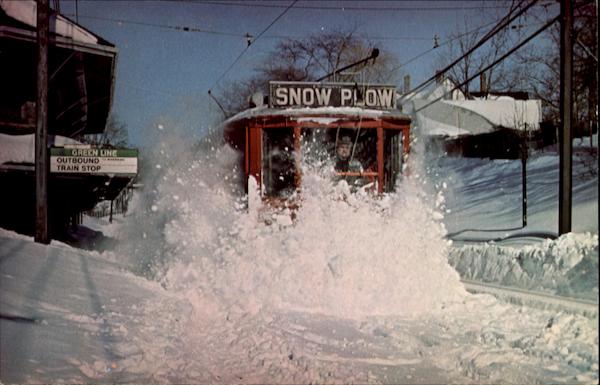
The T doesn’t have the same issues that DC has—MBTA cars have no issue running during storms and keeping the tracks clear. How do I know this? I went skiing during the storm and saw plenty of trains out and plenty of clear tracks. Tthe T even posted video of trains running during the storm. In fact, in 1978, the trains apparently didn’t run (the T was an all-PCC fleet back then, and those smaller-lighter cars may not have been as useful for clearing snow) and the T had to roll out a 1907-vintage snow plow to clear the tracks:
Source: CardCow.com
That’s an amazing photo, and apparently it was taken three days after the snow stopped falling. And it took six hours to plow the line. (I think the only thing that’s changed in this photo is that the overhead wire has been replaced with a catenary.) Even if the trains are running and the tracks are clear, it takes some time to clear off platforms so that people can get on to the trains. When it snows faster than crews can clear, which was certainly the case in this storm, a shut-down makes sense.
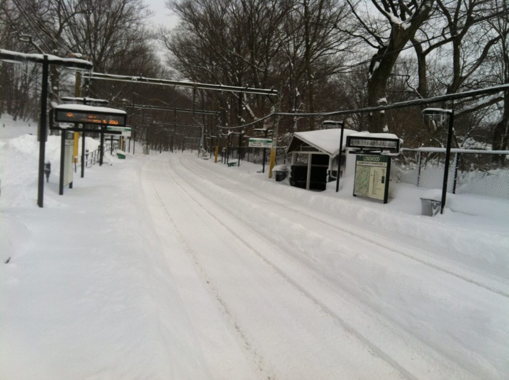
Tracks are clear at Longwood Station on Saturday morning, but the platforms are still buried.
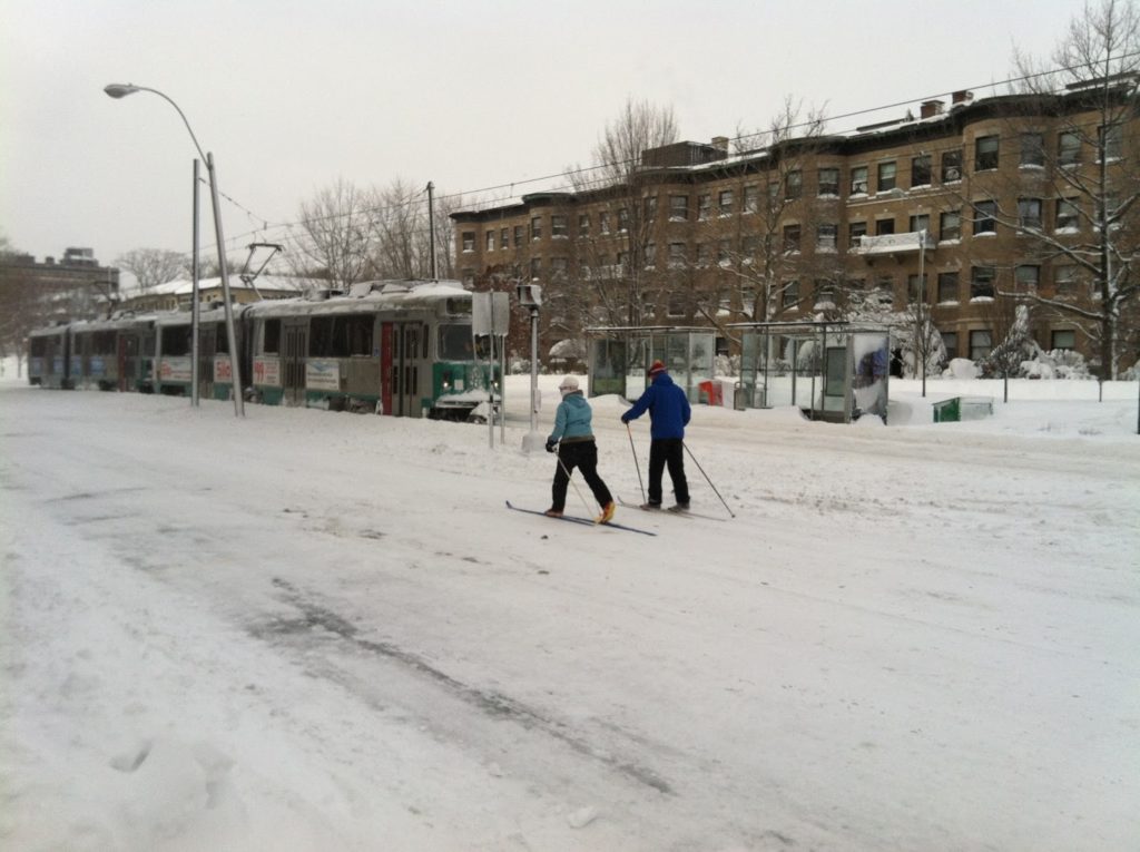
Skiers stride Beacon Street on Saturday as a snow clearance train rolls by.
Service would not resume for another 24 hours.
But what about the underground? The core segments of the MBTA run in tunnels, which are, by design, impervious to snow. Most stations have covered entrances, and those which do not could be top priority for shovel teams (Central Square, for instance), or have uncovered entrances temporarily closed (the Church Street entrance to Harvard, for example, or the auxiliary entrance in Kendall closer to the river). Intermediate, uncovered stations (Charles is the only one which comes to mind) could be temporarily closed, and the system could be run on a limited basis. For example:
Base map from Vanshnookenraggen, crudely cropped in, yes, MS Paint
Would this serve everyone? Certainly not. But it does provide service to several important areas, including downtown, Back Bay, Kendall and the airport. It also provides service to near major hospitals which are, of course, open through the storm. (The platforms at Charles could be shoveled to provide service to MGH.) Keeping this much of the system operational—with all-night service in the case of a road travel ban—would be a huge show of good faith by the MBTA and would quell most of the complaints that they aren’t doing enough to keep service running. It would also serve many travelers who have no other option during the storm. It, too, would take some advanced planning, but would provide better service.
I hope that, for the next storm, some of these steps will be taken. For instance, if service was better matched to the start of heavy snow and run through rush hour, then curtailed to underground portions of the system for the storm and then phased back in during the afternoon on Saturday, there would have been many fewer complaints about the overall storm service on the MBTA. This is not to say that the T didn’t do a good job—having full service on Monday took quite a concerted effort. (In addition, overall kudos to MassDOT: the highway shutdown meant that, unlike in New York, cars were not stranded in snow drifts on main highways.) It would be nice, however, to have a better plan of action for future storms.

When the T steps in it, what happens on Twitter

Not 10 minutes after I got in to the office today, word came out that there was a power problem on the Green Line, and the Red Line was in rough shape. This is a fine example that 44-year-old trains in 110-year-old tunnels need some investment. Next thing we knew, there were 30 minute wait for Red Line trains (scheduled headway: 4 minutes) and the Green Line was shut down at the peak of rush hour with inadequate bus replacement.

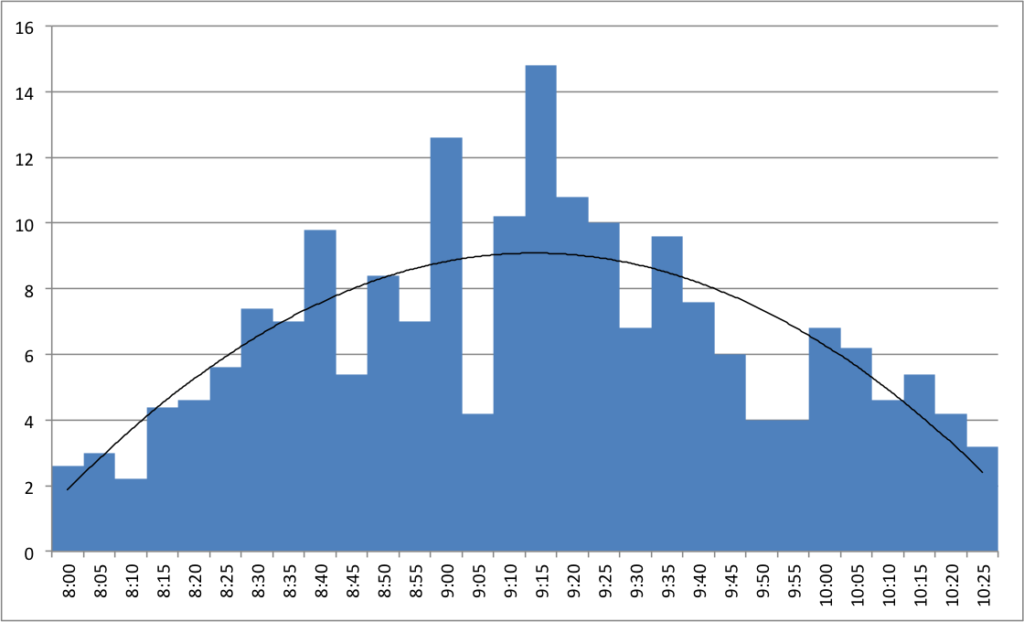
I was interested in looking at pictures from the junkshow, while sitting in a heated environment. And I realized that the number of Tweets tagged #MBTA was increasing. Starting at 8 a.m., the number of tweets per minute went from 3 per minute screaming up to triple that amount by 9 a.m. The tweets then leveled off and fell back. The Green Line was still shut down (it didn’t open until after 11:00) but the Red Line had recovered and the rush hour crunch had dissipated. Not much to comment on here, just a quick look at what happens to Twitter when two thirds of the MBTA’s ridership is affected by broken-down trains on a cold, cold morning.

What do you do with $13 billion

The Big News today is that the governor of Massachusetts has finally begun to detail how we are going to fund some sort of barely-functional-at-least transportation system in the Commonwealth. (No specifics on which revenue streams will be pursued, only that some will. Here’s to hoping we take the easy and best route.) More specifics are coming soon, but the state offered up a bit of a wish list of major projects these additional revenues could help fund (such as rebuilding the entire MBTA rail fleet and the bus fleet for RTAs across the state).

Now, this is obviously the first step in a game of political football, and certainly won’t be whatever is inked later this year (hopefully). Various interests (and even Republicans) will have their say, although business leaders seem to be all for increased funding and drivers may even grudgingly accept higher taxes. That can wait.

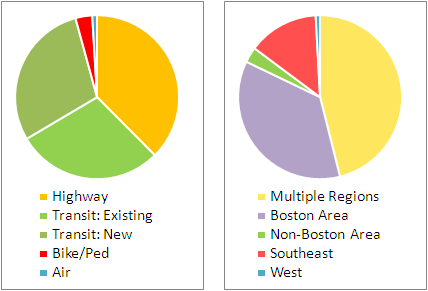
For now, I took the “wish list” and broke it down in two ways. First, I looked at each line item and what it funded: Air, Transit, Bike/Ped and Highway. I broke the transit out in to “existing” and “new” as the funding divides between improving existing services (such as replacing 40-year-old rail cars) and new funding for transit services which do not yet exist. This was a rough exercise, and certainly there is overlap (local highway funding will include bike/ped improvements, rail extensions will improve service on inner portions of the line) but it gives a good idea.

The second thing I looked at was whether each item benefited one region or multiple regions. This was even rougher. Some projects are statewide, some fund specific projects in multiple regions, and some are region-specific. The categories here were “Multiple Regions” (which includes statewide projects), “Non-Boston Area” (RTAs, mostly), “Boston Area”, and the West and Southeast parts of the state. There were no projects which specifically served the central or northeast regions, although they would be served in the statewide categories.

My quick takeaways:

  • More transit than highway, by an almost 2-to-1 margin.
  • No new highway construction—just rebuilding bottlenecked intersections. As far as I can tell, not even any highway widenings.
  • Bike/ped is a small percentage, but the raw number—$430 million—is quite big. Hopefully the $1 billion slated for local roadway improvements is mandated to create complete streets as well.
  • Most of the funding goes to the Boston area or the state as a whole; the big chunk for the Southeast is for the South Coast Rail project (and, yes, we can discuss whether that is a good use of funds later).
  • This is a pretty good start. Hopefully the highway lobby won’t throw up their hands and demand more roads, especially since bicycle and pedestrian projects create more jobs than highway projects.
  • This is a good start—but, yes, a start—towards tripling non-auto mode share in the Commonwealth (also see the linked article for Davey’s read-my-lips-no-new-superhighwas quote).

Cool map of the day

This past summer, I took a post from Alon Levy and charted out the ridership for New York’s commuter lines, and then built on that to chart the average speeds from various stations for the MBTA. (10 points if you’ve followed along so far.)

The next logical step, of course, was to map these. And someone has. Peter Dunn has mapped both the MBTA transit services and the commuter rail based on time. (His other maps are equally cool, I particularly like the ones of state highway shields and the Appalachian Trail.) The transit map (here’s the full scale version) is particularly useful in figuring out, visually, how far it is between different stations. Good stuff!

A minor quibble: he used Google trip finder to get the times between stations, although this time varies by time of day. For the Commuter Rail, thanks to express trains, there are several instances where the trip time from the last station before an express run (Natick, South Acton and Salem are examples) is actually faster than the next-closest station that doesn’t have express runs. This is a bit harder to show in these maps.

For transit, the T’s schedule is something of a junk show. What would be interesting is looking at how the transit maps change based on the time of day. The MBTA’s Blue Book (large PDF) has the scheduled run times for transit services at different times of day (see chapter 2, pages 13, 20, 24 and 28). There seem to be two factors which impact run time. One is that on lines with multiple branches (the Red and Green lines) there are more delays at junctions when trains are more frequent. The other is that, for all lines, dwell times increase when there are more passengers boarding and alighting the trains.

These differences vary between lines, but one stands out. Here are the longest and shortest run times for each line, with the range of average speeds:

Time Range
(min)
Speed Range
(mph)
Blue 18 – 23 15.5 – 19.8
Green (B) 33 – 53 7.4 – 12
Green (C) 23 – 42 8.3 – 15.1
Green (D) 34 – 46 16.3 – 21.6
Green (E) 25 – 35 8.8 – 12.3
Orange 32 – 36 18.5 – 20.1
Red (Ashmont) 35 – 42 16.7 – 20
Red (Braintree) 46 – 55 19.2 – 23

Notice anything? The slowest speeds are, of course, on the Green Line, although the grade-separated D Line attains speeds which match the other heavy rail lines (even while it has to traverse the painfully slow Central Subway). But even the Green Line has much more variability than it’s heavy rail counterparts. Why? Assuredly, a lot of it has to do with the lack of all-door boarding and on-board fare collection.

It would be interesting to compare two of Dunn’s maps, one showing the best case scenario for each line, and one (perhaps when moused-over) showing the worst case. In any case, good stuff.

Mass. gas taxes lower than region, nation; parity would go a long way

I drove out to Syracuse over the holidays. When I filled up with gas in Massachusetts, the going rate ranged from $3.30 to $3.45, at least outside of downtown (where the cost of land and logistics raise the price somewhat). In Syracuse, however, most stations were in the $3.60 range, and I held my nose (although not too hard; I had borrowed a Prius for the trip so even a full tank ran under $30) and filled up.

And I got to thinking: why is gas in Massachusetts so much cheaper? I know why it’s cheaper than New York City, where gas stations take up precious land and you can’t build above them (because how scary would it be to live in a building sitting atop a bomb)? But upstate? Does delivery cost more? Are there some extra regulations in New York and not Massachusetts? Is the gas tax higher?
Oh, right, the gas tax is higher.
Massachusetts has a middling gas tax of 23.5¢ per gallon, 24th lowest in the country (and it hasn’t gone up in more than 20 years). New York’s tax is the highest in the US, more than doubling Massachusetts at 51.3¢. (Here’s Wikipedia on gas taxes by state including the federal 18.4¢ tax). New York’s economy seems to get along fine, and the gas taxes assuredly help New Yorkers fund their transportation network.
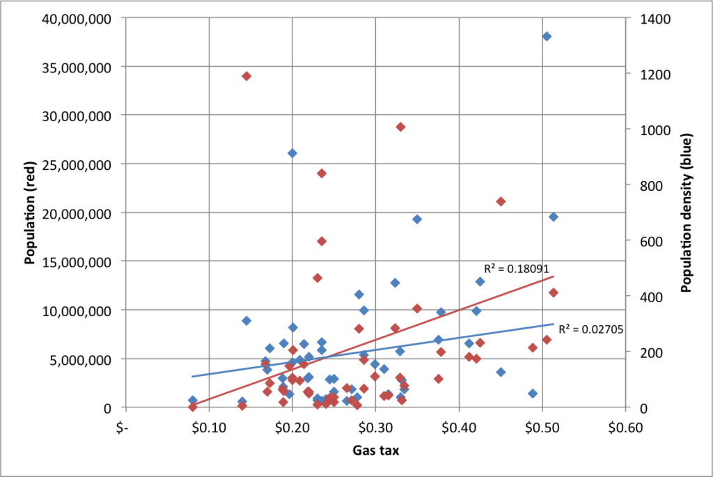
But Massachusetts lags even the national average of 27.5¢ per gallon. Gas prices are relatively well-correlated to state population (but, surprisingly, not by population density; see charts at the end of this post), so small, low-tax states skew this mean. Weighing the average by population shows that the average American pays a gas tax of 32.1¢ per gallon.
What about the region? How does Massachusetts compare against its neighbors, if not the whole country?
New York 
51.3¢
Maine
31.5¢
Connecticut
45¢
Vermont
26.5¢
Rhode Island
33¢
New Hampshire
19.6¢
Except for Live Free or Die New Hampshire, Massachusetts’ neighboring states pay higher gas taxes. Even in rural Maine and Vermont, where there are few transit options, gas taxes are higher. New York and Connecticut have dramatically higher taxes (putting thems in the top-10 highest gas tax states). Massachusetts seems like an anomaly here with lower gas taxes despite higher-priced neighbors and a transportation system which desperately needs the money.
The average in the region? 34.5¢. The weighted average? 46.7¢ (New York accounts for 71% of the population; Connecticut another 13%.)
Now, what would an increase gas tax would raise in Massachusetts? Last year, the MAPC put out a great MBTA budget calculator to try to close the gap in T funding. By their estimates, every 1¢ rise in the gas tax nets $27.7 million per year. Since even a 25¢ rise only accounts for a 7% rise in the overall gas price, we can assume that the gas tax wouldn’t decrease demand for fuel dramatically (demand for gasoline is quite inelastic). So here are some scenarios:
  • Match the national average of 27.5¢. Annual revenues: $110 million.
  • Match the national weighted average of 32.1¢. Annual revenues: $238 million.
  • Match the regional average of 34.5¢. Annual revenues of $305 million
  • Match the regional weighted average of 46.7¢. Annual revenues of $656 million
  • Match New York’s gas tax of 51.3¢. Annual revenues of $770 million
What if we raised the gas tax by 15¢ per gallon over three years—a nickel per year—and then did something really smart and indexed it to inflation? First of all, we’d still a ways from the top of the list of states by gas taxes. Three years out, we’d have somewhere along the lines of $400 million in additional gas tax revenue per year. I see this splitting in to five pots:
  1. MBTA operating subsidies. This could be 5¢ per gallon, although such a static cap could lead to issues if tax revenue lags like sales tax revenue did in the current budget predicament. Still, if there isn’t a huge debt transfer to the T (like there was in 2000) it would be less of a concern. (This 5¢ could also go towards Big Dig debt repayment, or that could come out of other portions of the tax.)
  2. RTA operating subsidies. 1¢ per gallon. Massachusetts regional transit authorities provide transit service to many cities and towns outside of the Boston area, and dedicated funding could allow them to improve and add service, as many operate limited schedules on only some days of the week. (The RTAs have less than 1/10th the ridership of the MBTA, so this is a higher per-rider subsidy and would help bring the votes of legislators from further afield.)
  3. Transit infrastructure improvements and projects. 4¢ per gallon. This money could probably be used to leverage private, local and federal funding.
  4. Highway infrastructure improvements and projects. 4¢ per gallon. This money would also probably help to leverage matching federal dollars.
  5. Bicycling and pedestrian improvements. 1¢ per gallon. It’s a small chunk of the puzzle, but $25 million per year would go a long way.
State policymakers in Massachusetts seem to realize that something has to be done about transportation funding. In the midst of the recession, business leaders called for a 25¢ gas tax hike. In 2009. 25¢ would give another $300 million per year for things like infrastructure improvements and debt payments (although it would still fall short of some estimates of the need for infrastructure improvements). This is the kind of sensible changes that we will need in order to have a functional transportation system. And if we look to our neighbors, we can see that, despite concern trolling (this article has a sad story about a guy filling up his wife’s Lincoln Navigator who might get hit for $500 a year—but apparently can afford to own and drive a 16 mpg Navigator) that always bubbles up when the gas tax is mentioned, raising the tax enough to begin to pay for our transportation system is certainly feasible.

As mentioned above, here’s a chart of gas taxes by population and density:

A quick note on Vehicle Miles Traveled taxing, or VMT: it may be a more palatable alternative to gas taxes, but it’s bad policy. First of all, it would require significant infrastructure to require people to have their odometers read, probably at a state inspection. It would also incentivize people to register their cars out of state, which is not a particularly difficult thing to do, especially for a state with a lot of migration in and out. Finally, a VMT tax disincentivizes driving, while a gas tax pulls double duty and discourages driving and the purchase of larger, less efficient vehicles. In other words, there is no logical argument for a VMT over a gas tax.

Failures in mapping

Just, yuck.

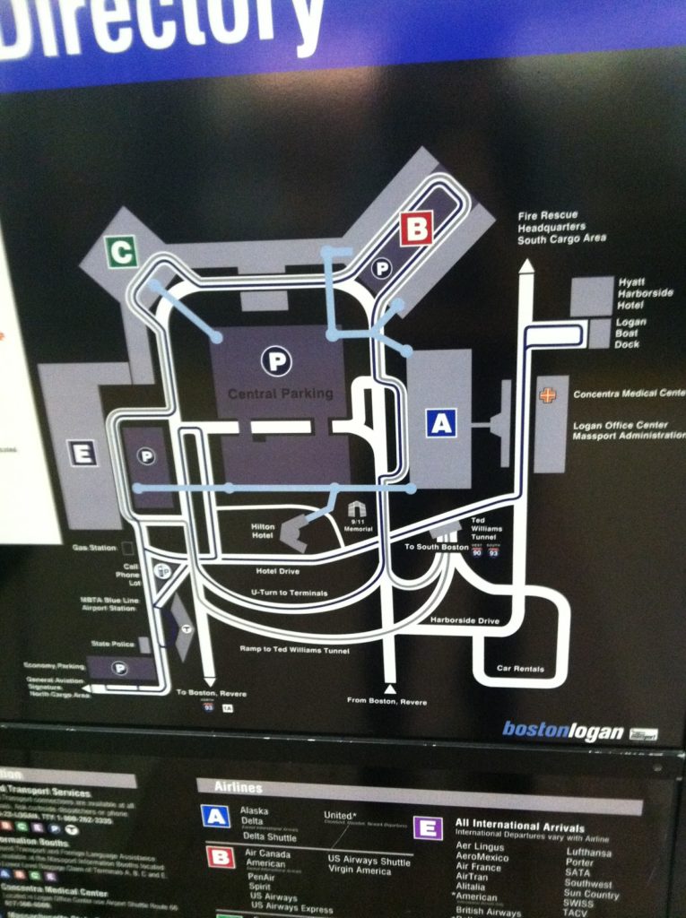
I was on the Silver Line today (mostly a failure on its own, but it does get you to the airport) and noticed what has to be one of the worst maps I’ve seen in recent memory. It’s a map of Logan Airport, located in the Silver Line platform area at South Station. It has some useful information, but it is so cluttered and so ill-presented that it might as well be in Greek. Or Swahili. It’s just a horrible representation of the information a transit traveler would need to navigate the airport.

  • It’s not to scale. That’s fine, but certain parts of the map are so not-to-scale that they are misrepresentations of where features are located. For instance, did you know the Airport Blue Line station is located right next to Terminal E? Neither did I. Hey, maybe you can walk there!
  • It implies that the Airport MBTA station is not in between the ramps in to and out of the airport from Route 1A. It is.
  • The bus routes on the map are incomprehensible. Lines which shouldn’t cross do cross, there are no arrows showing that the system is one-way, and there are some places where lines representing bus routes just end (look above the cell phone lot, for instance). And the Massport bus makes a big sweeping loop over itself for no apparent reason.
  • The color scheme is … gray, gray, gray, black and so-dark-a-blue-that-it-looks-black. But the terminals are colorful! Too bad we can’t really tell much else apart. Like the airport routes and the Silver Line.
  • Terminal A is shown with its auxiliary gates, but there’s no gate detail for any other terminal. This is extraneous, and confusing; who cares what’s on the other side of security when you’re standing at South Station. Also, Terminal B isn’t shown as being two separate stops, it is just a big B in the middle of the parking. (Oh, and don’t worry, because when you get to Terminal B and don’t know which stop to get off at, there’s a chance the audio announcement will be through the whole list of airlines by the time the bus leaves the station.)
  • There are way too many roads. I don’t care how roads loop around and over each other to get to Boston. Or where car rentals are. Or even where the parking garages are. If I’m in the Silver Line Station, I’m probably not driving to the airport. I know this may be a stock map of the airport, but in that case it doesn’t belong at South Station.
  • The Silver Line routes to and from South Station should be labeled as such. They don’t even say “South Station”! Instead it’s labeled as “To South Boston.” That’s pretty misleading. Although not as misleading as calling the Ted I-90 and I-93. That’s just plain wrong. Again. Silver Line, not driving.
  • Okay, so maybe the I-93 and I-90 belong with the “to South Boston,” as in “to 90 and 93.” But it’s not to I-90, it is I-90. It’s to I-93. In any case, there should be some differentiation between what it is and what it is to. Good lord, can it get any worse?
  • And once you get to South Station, what line to you transfer to? Beats the hell out of me. God forbid they put in something about the Red Line.
  • In fact, the only time a T logo appears on the map is down at the Blue Line Station. Is there anything about that being the Blue Line? Nope. There’s some text off in the corner but this is a schematic map. Oh and the label for the station? About half way across the map. But if you were at South Station, you might see the T, and wonder if you’d wind up there after your trip. Negative.
  • Can you walk indoors from Terminal C to Terminal E? I have no idea. And this map doesn’t really make it seem one way or the other. Or let you know that you can take a sidewalk between these terminals.
  • The blue lines showing elevated, inter-terminal walkways are one of the better features of this map. However, even here the symbology is not consistent. Sometimes they end in blue circles. Sometimes the line just ends. Sometimes the line ends in the middle of a parking facility (Terminal E) with no cue as to whether you can get to the terminal, where the skyway actually extends (and if you ever miss a Silver Line bus by a hair at Terminal A, you can hustle across to Terminal C or E faster than the bus can round the airport). This is a complete graphic design fiasco!
  • I’m not even going get started on what is going on with the road through Central Parking.
  • It’s all well and good that the South Cargo Area is shown on the map, but I’m not sure how pertinent that is for anyone at South Station.
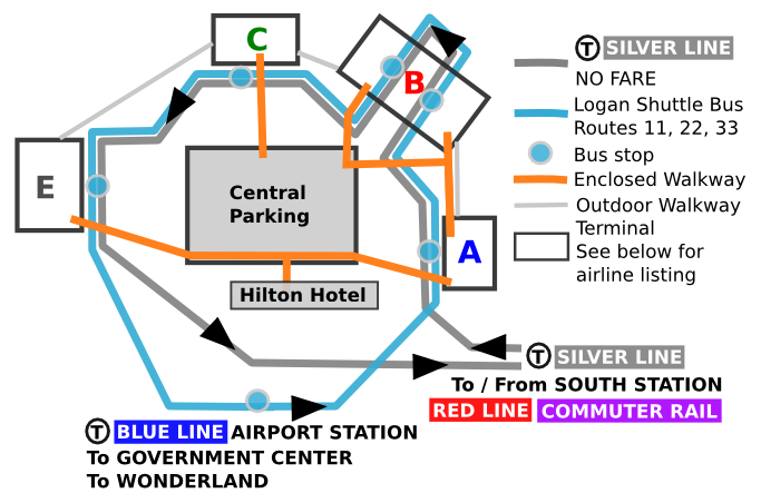
Now, I’m no graphic designer (see my Hubway data viz if you want proof of this) but in an hour on a airplane I sketched up with a better and more useful map than this. (It’s pretty bad, but not this horrible.)
Perfect? Hardly. But it is superior in every way to the photo above. It drops a lot of extraneous information, but adds in things that make it a lot more useful. Now, Massport, which is swimming in money from parking fees, should design something at least this useful on their own.

UPDATE: Posted a new/better map here.

In other words, #fail.

(As for Logan, a hodgepodge of terminals that makes little sense and is generally added to with little plan for the future, it should be added to Dave Barry’s list of airports that should be “renovated with nuclear weapons”. Although, thanks to the new tunnel, it is now easier to get to from downtown Boston than Colorado, which was not necessarily the case in 1999.)

Yelp Transit Maps

Yelp-rated routes in Boston. Click to embiggen.

I noticed a while ago—as did some other folks—that Yelp users have been, for some time, rating transit lines. I was intrigued. Here was really interesting data about how people felt about different transit lines, distilled in to a simple 1-to-5 rating. While not every line was ranked in Boston (my first search) there were plenty that were, and I compiled a list of routes, star-ratings and the number of Yelps.

In Boston, only some routes were rated, and they were, not surprisingly, centered in the more student- and hipster-centric part of the city. For instance, no bus line in Dorchester or Mattapan got Yelped, but most in Cambridge and Somerville have many reviews. I figured the best way to show these data was on a map, and after some machinations (especially in resorting the shapefile so the thinner lines would display on top of the thicker ones) I got the map above. It’s pretty cool—click it to enlarge. (Here’s the full MBTA system map if you’re not familiar with the lines; I left off route numbers for clarity.)

But I realized that pretty cool wasn’t cool enough. There was probably a much richer data set out there. Boston has about 750 Yelp reviews, 450 of those for rail lines. Was there city with a wired-in community, lots of bus and transit routes, and high transit ridership? Did I just describe San Francisco to a T? And, voila, there are nearly 2000 Yelp reviews of transit lines in San Francisco, at least one (and usually many more) for nearly every line Muni runs (see exceptions below). (Here’s the Muni system map.)

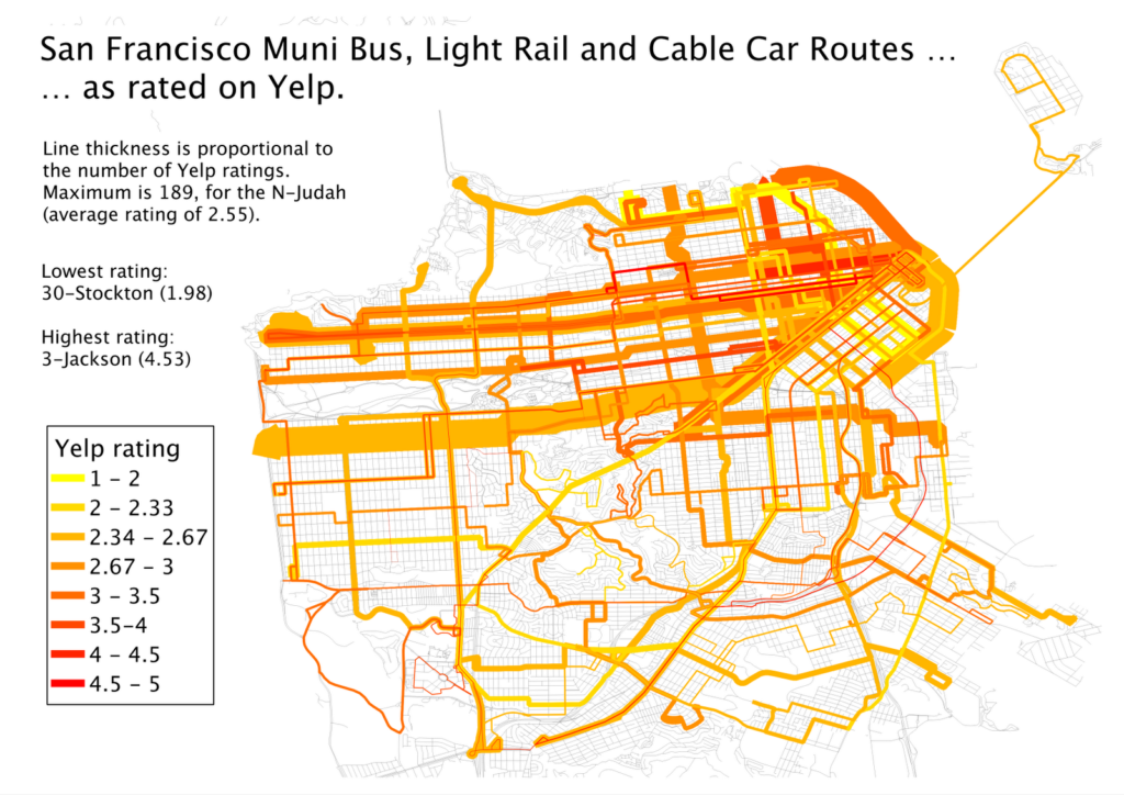
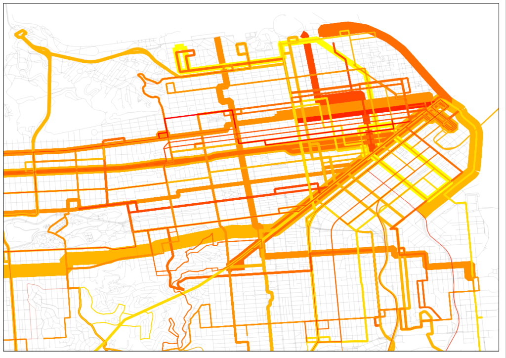
Muni Lines, as reviewed by Yelp. Click to Embiggen.
San Francisco inset. Click to embiggen.

That. Is. Sexy. The N-Judah has nearly 200 reviews. Wow. And in case the downtown area is too clustered for you, there’s an inset to the right.

I also realized that I had a pretty fun data set here, too. I went to a talk by Jarrett Walker the other day at MIT where he mentioned, amongst other things, that we should not focus on the technology used for transit, but whether if fulfills the mission of getting people from one place to another. In San Francisco, we have a jumble of buses, trolleybuses, streetcars and even cable cars and we have a pretty good way of quantifying whether they are accomplishing the job of transit. (In Boston, even though the B Line serves tens of thousands of passengers a day it manages a 1.36 Yelp rating—remarkable as the lowest possible rating is 1. None of its 34 raters give it a 4 or a 5. Still, it moves a lot of people marginally faster than they could walk.)

First, I averaged the ratings by technology type. Trolleybus route get more reviews than bus routes, probably because they are more heavily used. The average rating for these, however, is quite similar. (The average is a straight average of each line, the weighted average weighs more frequently-rated lines by the number of ratings). Cable cars and PCCs (F-Marked and Wharves) have higher ratings but many are likely by tourists. Light rail lines, however, are frequently rated, and given low ratings, significantly lower than the bus routes.
Vehicle type Routes Avg Reviews Avg Stars Weighted Avg
Bus 39 22 3.03 2.77
Trolleybus 12 41 2.95 2.79
Cable Car 3 64 3.81 3.87
PCC 1 114 3.42 3.42
Light Rail 5 65 2.31 2.43
A forthcoming post will compare local and express bus routes. (Hint: people like riding expresses more than locals.)

I am so interested in San Francisco’s Yelp bus ratings that I’ve tabled the whole of the network.

Line Vehicle Stars # Ratings Line Vehicle Stars # Ratings
1 Trolleybus 2.96 78 48 Bus 2.71 17
2 Bus 2.53 26 49 Bus 2.33 40
3 Trolleybus 4.53 17 52 Bus 2.5 8
5 Trolleybus 2.73 55 54 Bus 2.6 10
6 Trolleybus 2.88 16 66 Bus 4 1
9 Bus 2.42 26 67 Bus 3.4 5
10 Bus 3 24 71 Bus 2.56 27
12 Bus 3.33 15 108 Bus 2.5 16
14 Bus 2.55 44 01AX Bus 3.67 6
17 Bus 3.67 6 01BX Bus 3.31 13
18 Bus 3.25 16 08X Bus 2.56 18
19 Bus 2.66 41 14L Bus 4 3
21 Trolleybus 3.58 31 14X Bus 4 6
22 Trolleybus 2.74 92 28L Bus 4.33 3
23 Bus 3 9 30X Bus 3.2 35
24 Trolleybus 2.81 32 31AX Bus 3.56 9
27 Bus 2.07 28 31BX Bus 3.75 8
28 Bus 2.48 42 38AX Bus 3.71 14
29 Bus 2.5 36 38BX Bus 3.29 7
30 Trolleybus 1.98 82 38L Bus 3.44 61
31 Trolleybus 2.48 23 71L Bus 3.5 10
33 Trolleybus 3.24 33 California Cable Car 4.13 69
36 Bus 2.1 10 F PCC Streetcar 3.42 114
37 Bus 3.42 12 J Light Rail 2.49 45
38 Bus 2.45 119 KT Light Rail 2.13 23
41 Trolleybus 2.82 17 L Light Rail 2.13 38
43 Bus 2.82 28 M Light Rail 2.23 31
44 Bus 2.83 24 N Light Rail 2.55 189
45 Trolleybus 2.62 21 Powell-Hyde Cable Car 3.78 99
47 Bus 2.13 23 Powell-Mason Cable Car 3.52 25

The only lines not Yelped are the 35-Eureka and 56-Rutland. These lines have 30-minute headways (as does the 17-Parkmerced, see this route service chart with headways for all lines) while most lines in San Francisco have service every 15 minutes or better.

Next up: New York’s subways. And beyond.