No need to duplicate transit on Comm Ave

NB: This got picked up on Universal Hub and there are a bunch of comments there. I’ll respond to comments in both forums, but probably here more. One note of clarification: I’m not saying that this should be the plan, but that it should be considered. Like much of the Commonwealth Avenue project, the planning process has been opaque and has had no public input. Also, this comment is a great illustration of what you could have.

The Boston Globe recently ran a story about proposed changes to Commonwealth Avenue. Of issue is that while Comm Ave is wide, it is not infinitely wide, and the changes will widen the transit reservation (mainly for safety for track workers, presumably this would also allow for wider stations), narrowing the rest of the road enough that the city is reticent to add cycle tracks, because it would narrow bus stops, and stopped buses would delay vehicles. (I’m just going to touch on the fact that there really shouldn’t be an issue with delaying traffic in favor of buses, bicyclists and pedestrians, but that’s not the scope of this post.)

What I am going to point out is that all of these issues could be mitigated by moving the 57 bus route and the BU buses to the center reservation of Comm Ave with the trolley tracks. This would result in the removal of bus infrastructure from the sides of the street—buses could instead stop at the same stations as Green Line trains. While this would be novel for Boston, it has been used in other cities, and while it could result in delays for transit riders, with better stations and transit signal priority, it would result in a better experience for all customers.

There are a variety of benefits from such a plan:

  •  Buses would move out of mixed traffic, resulting in fewer traffic delays for buses (especially at the busy BU Bridge intersection) and fewer conflicts between buses and traffic.
  • The duplicative infrastructure of having parallel bus and trolley stops would be eliminated. In their place, larger, more substantial stations could be built in the center transit median.
  • Instead of waiting for either a bus or a trolley, riders could board “whatever comes first” for short trips between Packards Corner and Kenmore Square, and riders wishing to go further east than Kenmore could take a bus to Kenmore and transfer down to a B, C or D car.
  • Removing bus stops would eliminate the conflict with buses pulling across the bike lanes when entering and exiting stops.
  • Removing bus stops would allow for more parking spaces to be added to the street. The number would be small—probably in the 12 to 18 range—but not negligible, and would assuage the (dubious) constant calls for more parking in the area.
  • In addition, there would no longer be issues with cars and taxicabs blocking bus stops, requiring buses to stop in the travel lanes.
  • Wider stations would better serve disabled users, with higher platforms better allowing wheelchairs and other disabled users to board and alight transit vehicles.
  • Narrower side lanes (parked cars are narrower than buses) would allow for more bicycle and sidewalk space, including the possibility of cycle tracks.
  • Without bus stops, there would be no need for bus passengers to get off of buses and cross a cycling facility.
  • With signal priority implemented, transit travel times through the corridor could be improved for bus and trolley riders.

The main reason to not to do this is that it hasn’t been done before. The cost to pave the trackbed—and to pave it well—wouldn’t be negligible, but since the entire corridor is under construction, it would be feasible. There would have to be some study to see if the number of vehicles would cause congestion in the transit reservation.

Additionally, there would have to be a specific signal to allow buses to enter and leave the corridor at each end of the corridor—especially the east end where they would have to merge back in to traffic. However, the 57 bus would only have to merge in to and out of the left lane since it then accesses the busway at Kenmore, which is in the center of the roadway. This could be attained with a signal activated by the approaching vehicle—again, a novelty in Boston, but by no means a procedure without global precedent.

The B line has 26,000 surface boardings, most of which travel to Boston University or through the campus and in to the tunnel. The 57 bus adds 10,000 more, and the BU Bus serves countless others. There are tens of thousands of pedestrians in the corridor, and thousands of bicyclists—it is one of the most heavily-traveled bicycle corridors in the city. Yet we are planning for cars—minority users of the corridor—first, when we should be planning for transit first (by far the largest user of the corridor by the number of passengers carried), then bicyclists and pedestrians. Cars should be an afterthought, put in to the plans after other users have been accommodated, not before. Of course, had the old A line never been converted to buses, Commonwealth Avenue would not host any MBTA services, and wouldn’t need any bus infrastructure. But that battle was lost 45 years ago.

The next person to say “The same as 1897” …

Every so often, someone knocks the MBTA. I know, I know, it’s shooting fish in a barrel. But sometimes you hear that the T built the first subway in 1897, and hasn’t made any real improvements since. (I’m looking at a certain “disruptive” transit service here: “Between 1897 and right now, there’s been some marginal improvements in how service is delivered to move massive amounts of people throughout a city.”) In 1897, the underground transit in Boston was composed of streetcars. Mostly short streetcars. Here’s the article about the first streetcar through the tunnel: a car from Allston via Pearl Street. Here’s that streetcar (or one like it): a 29-foot car. Back then, a parade of 25-to-30 foot vehicles (most of them just eight feet wide) plied the subway. It was better than the gridlock at the surface, but didn’t have a huge capacity.

By 1901, the Main Line Elevated operated first through the current Green Line tunnel, and by 1908 through its own tunnel. These ran four-car trains of 65-foot cars that were 9 feet wide—still narrow, but much larger than the 1897 cars.

In 1912, the Cambridge-Dorchester tunnel (The Red Line) opened in 1912, and the Orange Line cars had proved inadequate for the crowds, so the T opted bigger. These cars were 69 feet long and 10 feet wide, triple the size of a streetcar one level up at Park, but operating in four car trains. The tunnels were wider too, with fewer curves, allowing faster operation. In 15 years, there were trains an order of magnitude larger than the first iteration.

(A similar thing happened in New York: the IRT cars—in 1904—were built to approximately the size of the Orange Line fleet, by the time the BMT built their tunnels ten years later, they were using Red Line-sized cars.)

But let’s go back to the Green Line. It took a bit longer, but the Green Line trains grew by an order of magnitude, too. By the 1940s, they were running three-car trains of PCCs, 47 feet long and more than 8 feet wide. In the 1970s, the first articulated vehicles showed up, and current Green Line trains are 8’8″ wide, and 74 feet long. And they operate in three-car trains. That’s 222 feet long—quite a bit longer than 29 feet—and, overall, nine times as big. It took some time—three car trains have only started running recent years—but the Green Line has improved capacity an order of magnitude, despite the 115-year-old infrastructure.

Oh, right, in 1897 (and 1997) you paid with a coin, now you pay with an RFID card. And sometimes the trains even have air conditioning! But that’s another story.

In other words, knocking rapid transit for “marginal” improvements in the last 115 years isn’t disingenuous: it’s wrong.

Longfellow Bike Count: Year 2

It’s kind of hard to believe that it’s been more than a year since my first Longfellow Bridge bike count, but it has. I’ve posted just a few times since then about the bridge, and seen the inbound lanes deconstructed, the towers come down, and, arch-by-arch, the bridge is now being rebuilt. I even went out in the middle of winter (and by out, I mean in to someone’s office with a view of the bridge) and counted about 90 bikes per hour: 30% of the previous summer’s crossings. (I think I tweeted this during the winter but didn’t write a whole post.)

So it was high time for a new count. I waited for a morning with good weather (and when I wouldn’t miss November Project) and set off for the bridge. After chatting with the DPW workers on my street about Hubway, I didn’t make it on to the bridge until 7:45, but that meant I was there in plenty of time to hit the peak morning bike rush hour, which (still) occurs from approximately 8:10 to 9:10 on the Longfellow. While at first the bike counts seemed flat or even down, once the rush got cranking, it became clear that there are more bicyclists this year than last.

Just to review, here are the bike counts for the peak hour from last year:

Wednesday, June 19, 2013: 267 bicyclists (8:12 – 9:12)
Tuesday, July 30, 2013: 308 bicyclists (8:08 – 9:08)
Tuesday, October 15, 2013: 298 bicyclists (8:11 – 9:11)

Here’s what I found this June (on the 24th, a Tuesday). The counts today peaked from 8:07 to 9:15 (that is to say, the 8:07 – 9:07 hour and the 8:15 – 9:15 hour saw the same counts). And the number of cyclists during those 60 minute blocks?

384

That’s one bike every nine seconds for an hour. Compared with the highest count last year in July, it’s an increase of 25%. Compared with the average of the three counts last year, it’s an increase of 32%. In a single year.

I can’t think of any single factor that would have increase bicycle usage by that much, other than more people riding bikes. So, contrary to any mitigating factors, I’m operating under the assumption that bicycling eastbound across the Longfellow is up by at least 25% this year. Between 8:30 and 9:00, there were 221 cyclists crossing the bridge and only 187 vehicles: 18% more bikes than cars. There were a few moments where the bridge looked downright Copenhagenish. With more bicyclists than vehicles crossing the bridge at peak times, perhaps it’s time to revisit the design and give bikes more than 20% of the road’s real estate.

Tolls, traffic and unintended consequences

Back in 1996, Governor Bill Weld wanted to be Senator. John Kerry was running for his third term. Amidst the clash of blue-blooded New Englanders, Weld decided it would be a great political coup to remove tolls on two sections of the Massachusetts Turnpike. So he zeroed out the tolls in Western Mass (which mainly required new tickets—yes, that was pre-EZ-Pass—as the highway still required toll barriers; the tolls were reinstated last year to little fanfare) and nixed the toll in Weston Newton. While the Western Mass tolls were a quiet affair, the West Newton tolls were less so.

Overnight, signs went up: Toll Free. One day when I was biking home from middle school (yes, middle school, and yes, I was a commie bicyclist even then!) I noticed a peculiar sight: a backhoe was tearing in to the old toll booths, and within a few days they were gone, paved over would never be seen again. Of course, this was a transparent political ploy, and it soon surfaced that Weld hadn’t publicly bid the demolition contract but instead given it to a friend. He lost the election by seven points. 
And overnight, he created a nearly-twenty-year-long traffic jam. (Yes, this was predicted by some at the time, although the Globe article is archived so you need a login, and yes, all of this really happened.)

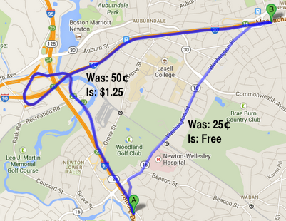
Much of the traffic coming east on the Turnpike originates on Route 128. When the Southwest and Northwest expressways were canceled, the Pike became the only western trunk route in to the city. Up until that point, the toll to access the Turnpike at 128 was 50¢, and in West Newton it was 25¢. Traffic from the south on 128 has little incentive to stay on 128 to the Turnpike, as the diagonal Route 16 is two miles shorter and, even with traffic lights, negligibly slower, especially given the roundabout design of the 90/128 interchange, where Boston-bound motorists drive half a mile due west before swinging back east through the toll gates. Until 1996, there was a 25¢ difference between staying on the highway and taking the surface roads. In 1996, the savings went to 50¢, and when tolls were raised in 2002, to $1.00 (it stands at $1.25 today). This was a four-fold increase in the direct cost savings over those six years, and there was suddenly a much higher incentive to take the Route 16 shortcut and save a dollar.

And guess what happened on Route 16? Traffic tripled, and gridlock ensued. Exit 16—coincidentally, where Route 16 intersects the Turnpike—was never anticipated to be more than a local access exit. It has a short acceleration zone and a very short merge with poor sightlines around a bridge abutment. And it began to handle far more traffic than it had before. (On the other hand, the outbound ramp no longer required vehicles to slow through the toll plaza, and they frequently merged in to Washington Street at highway speed at a blind corner with significant pedestrian traffic.) With more cars coming off of Route 16 rather than the main line, it created a merge which caused traffic back-ups a mile back Route 16, and—given the merge—also backed up traffic on the mainline of the Turnpike. Additionally, drivers who may have, in the past, stayed on Route 16 between West Newton and Newton Corner instead used the free segment of highway, adding to the traffic along the Turnpike and causing more backups at the short exit ramp there. One shortsighted, unstudied policy change changed the economic decisions of drivers on several segments of road, changed the equilibrium, and caused several different traffic jams.

And the state lost money, to boot.

So the new electronic toll can’t come soon enough. It’s too hard to tell if it will rebalance the traffic, or if growing traffic volumes in the intervening 18 years have created this traffic in any event. But it will finally correct a problem nearly two decades in the making by a governor trying to score political points; a problem that never should have occurred in the first place.

The new Blue Book is out

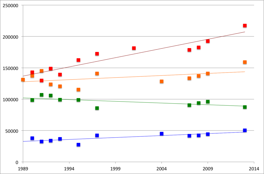
Every few years, the MBTA publishes the Blue Book. It is a compendium of data, neatly packaged in a PDF format. (It would be nice if they published a Blue CSV, but that’s asking a lot of a public transit agency.) I haven’t had much time to play with it, but did download the data for the core subway lines, to compare 2013 to 2009 (the last Blue Book) and before.

This shows data for each subway line (N.B.: it only shows subway boardings for the Green Line) for the past 25 years. The Red, Orange and Blue lines all grew by 13% since 2009, and compared to their lowest count over the past quarter century, they are up 67%, 38% and 82%, respectively. All three lines saw their highest ridership in 2013. If the trains seem crowded, it’s because they are carrying significantly more riders now than they were just a few years ago.

Then there’s the Green Line. It seems that ridership there is flat, but I haven’t had a chance to look at the branches. It might be due to it’s slow speeds, arduous boarding process, arcane rules, lack of traffic priority or a combination of these factors. Or it could be that it’s already basically at capacity, at least as currently configured.

I’ll have more analysis—including station-by-station counts (very variable) and bus routes (they’re growing)—in the coming days.

Deconstructing the “don’t bike with a helmet” crowd

It seems like something that occurs every few months. Someone doesn’t like wearing bike helmets, and rather than ride around without a helmet on, they decide that everyone would bike more if it wasn’t for those pesky helmets, and they decide to write about it on the Internet. They find some studies, draw some conclusions, and use data to say “hey, look, it’s actually safer to bike without a helmet.” Here’s the thing:

THEY ARE WRONG.

The latest installment comes from Howie Chong. I’m sure Howie is a heck of a guy. But before he tells people not to wear helmets, he should get his facts straighter. Here’s his thesis:

I have made a careful and conscientious choice to not wear a helmet when I’m cycling in urban areas because I strongly believe that it will help improve the overall safety of cycling in the long run.

And here’s what I have to say about it …

Let’s first get one thing out of the way: if you get into a serious accident, wearing a helmet will probably save your life. According to a 1989 study in the New England Journal of Medicine, riders with helmets had an 85% reduction in their risk of head injury and an 88% reduction in their risk of brain injury. That’s an overwhelming number that’s backed up study after study. Nearly every study of hospital admission rates, helmeted cyclists are far less likely to receive serious head and brain injuries.

If the piece he wrote ended here, it would be fine. Studies do back this up. If you are in a crash, a helmet will dramatically improve outcomes. Now, he’s going to spend a few dozen paragraphs circling around this with some very loose logic attempting to negate all of these benefits. He describes auto traffic and goes on:

So a helmet provides a level of protection from this danger. It makes you feel safer.

 No! A helmet does not make you feel safer. This is false equivalence. On the one side, we have data showing that a helmet makes you safer. As he points out in his first paragraph, a helmet makes you safer. On the other side, we have a perception of how a bicycle rider feels (he extrapolates this to all riders). It it not touchy-feely. Helmets reduce the risk of head injury seven-fold. That’s not a feeling.

But a broader look at the statistics show that cyclists’ fear of head trauma is irrational if we compare it to some other risks.

He goes on to cite a 1978 study from San Diego that attributes 6% of head injuries to bicycling and 53% to automobiles.

The studies that are out there give us mixed messages about the relative safety of the different modes of transport. What I am saying is that these statistics raise an interesting question: If we’re so concerned about head injuries, why don’t we wear helmets all the time? Why do places that have mandatory helmet laws for cyclists not have them for drivers or pedestrians? 

 No, they don’t give us mixed messages. They just don’t give us enough data. I don’t have the numbers from 1978, but more recently (from 1990 to today; there has been little bicycling growth in San Diego), about 1% of San Diegans biked to work. 85% drove. Once you control for these denominators, the numbers change dramatically. Bicyclists account for 600% more head injuries than would be expected based on their mode share, cars account for 60% fewer. Drivers have seat belts designed to keep their heads away from hard objects. Pedestrians are usually on sidewalks and only interact with vehicles in intersections. Bicyclists, on the other hand, have none of these protections.

He goes on to describe a Forbes article which suggests that graduated licenses are the best way to reduce head injuries among teenager short of forcing them to wear helmets, a comment made surely in jest. His response:

Despite the fact that car accidents are the number one cause of all fatal head trauma among teenagers, the suggestion that teens wear helmets when they drive is simply brushed off. The passage treats the idea of mandatory driving helmets as completely preposterous.

Again: No! The idea of wearing helmets is preposterous because helmets would not help in a car accident. There are certainly no studies. What keeps you safe in car accidents are seat belts and headrests. If you are properly bucked in to a car and are in an accident, your risk of head injury is dramatically reduced because your head is kept away from metal and pavement. This is what headrests and seat belts and roll cages are designed to do. A helmet would just sit there flopping around. He asks “Why has cycling been singled out as an activity in need of head protection?” Because we’ve already addressed passive protection in cars.

He doubles down:

Bike helmets may reduce the risk of head and brain injury by 85-88%—but only for those who get into accidents.

Oh, good, I’ll just never get hit by cars. Good.

If we take a closer look at the article we see that both the experiment and the control groups studied are those who have already been hospitalized for bike injuries. … Studies show that helmeted cyclists who are hospitalized are far less likely to have serious head trauma than bare-headed cyclists that have been hospitalized. But wouldn’t this be true, regardless of the activity? Logically, helmeted drivers should also receive significantly fewer head injuries than bare-headed drivers. Similarly, helmeted pedestrians should be less likely to receive serious head trauma than bare-headed ones. 

But such studies don’t exist because there aren’t enough helmeted drivers or pedestrians to make a comparison. In other words, one of the reasons we think helmeted cyclists are safer than unhelmeted ones may be due to availability of information more than actual levels of head safety. 

Maybe that explains why there’s no comparable fear of driving or walking without a helmet.

My head is spinning. Where to begin. How about “Logically, helmeted drivers [are safer].” This is illogical. Again, drivers in cars are protected by different mechanisms which achieve similar results. Seat belt use dramatically reduces the severity of head injuries. Think of the seat belt as the helmet of a car. It’s the first line of defense. It serves the same purpose. And there are plenty of studies that show this. There is no information deficit. Comparing helmet use among drivers and cyclists is comparing apples to oranges. Helmet use to seat belt use is the right comparison here.

He goes on to cite a New York Times article from 2001 regarding helmet use. It, however, does not draw any conclusions, and several of the anecdotes it gives pertain to mountain biking, not the kind of bicycle commuting which has grown dramatically in the past 15 years. It doesn’t conclude that more helmets correlate with higher head injury rates. If it comes to any conclusion, it’s that helmet use is just a part of bicycle safety.

Then he goes on about a study which shows that drivers will give more space to an unhelmeted cyclist than a helmeted one. Fine. How about education and enforcement for cars which squeeze bicyclists, whether they’re wearing a helmet or not.

The he gets in to mandatory helmet laws.

So as much as helmets decrease the chance of head injury when you get into an accident, they may actually increase your chance of getting into an injury in the first place.

Again, this is a very much false equivalence. On the one hand, helmets make you safer, and there’s data to back that up. On the other hand, they may increase your chance of being in an accident, but no one knows. They may not.

There is another significant way that the use of helmets harm cyclists: Bike helmets discourage cycling. An Australian study on mandatory helmet laws concluded that laws that required cyclists to wear head protection actually decreased the number of cyclists on the road. The implication of this study? The fewer cyclists on the road, the less likely drivers will be accustomed to sharing road space with cyclists, ultimately increasing the hazards faced by cyclists and further dissuading people from hopping on their bikes.

First of all, this is regarding a mandatory helmet law. I lived in Melbourne and people were not happy about that law. But a helmet law is very different than suggesting that people wear a helmet. In the US, at least, if people don’t wear a helmet they don’t have to worry about being given a $100 ticket. That is much of what discourages cycling where helmets are mandatory. I agree that helmet laws are heavy-handed and bad policy (for bicyclists, anyway; they are certainly a good idea for motorcyclists).

[O]ur society has conditioned cyclists to feel unsafe without a helmet, even though wearing one might actually increase the chance of a collision with a vehicle; and even though other activities capable of inflicting serious head wounds are enjoyed bare-headed without stigma.

Again with the false equivalence. We feel unsafe without a helmet because it is statistically less safe to bike without a helmet. There is no data that shows that cyclists without helmets get in to fewer accidents.

Helmet use is very uncommon in bike-friendly cities like Copenhagen and Amsterdam, where cyclists have been socialized to see cycling as a safe activity. In order to promote the same culture here, we need to encourage people who don’t bike that they should give it a try.

What else do they have in Amsterdam and Copenhagen? They have protected bicycle infrastructure. They have laws which assign blame and real, actual legal remedies to drivers involved in bike-car collisions. Nearly everyone is, at some point, a cyclist, so they know to look for other cyclists, even when they’re driving. The assertion that if we don’t wear helmets we’ll suddenly turn in to Copenhagen is ridiculous.

If there was conclusive proof that bike helmets reduce the total number of serious head injuries compared to other normal activities, then I’d reconsider my stance.

There is conclusive proof! This “other normal activities” (driving and walking) is a total red herring; we don’t wear helmets when driving because we have other protections in place, and we don’t walk in mixed traffic on the highway. This statement is completely illogical.

But if I’m not the kind of person who wears a helmet when I take a walk or get behind the wheel of a car, then there’s no logic to me wearing one when I’m on a bike, particularly if I’m confident in my urban bike safety ability. 

Do you put on a seat belt when you get in a car? If so, you are the kind of person who wears a helmet when you get behind the wheel of a car. (I’ll get to the confidence in urban bike safety in a moment.)

Meanwhile the proof is pretty strong that vehicles give me more space when I’m biking without a helmet.

Okay. So you dismiss the proof that wearing a helmet makes you safer. But when it comes to a single study that shows that unhelmeted cyclists, it holds a lot of water. The study also showed female cyclists got more room. Maybe Mr. Chong should consider a sex change, or at least a wig.

In a city biking, that’s the kind of injury I’m most concerned about. 

Now, let’s go in to personal anecdotes. About two years ago, I was biking to work. 2.5 miles, mostly in bike lanes, and on a route I knew very, very well. It’s the exact type of situation that Mr. Chong would eschew a helmet:

  • I was on a street with a bike lane 
  • It was sunny and warm 
  • I was biking in the only League of American Bicyclists Gold-rated city on the East Coast 
  • I was in a city with a 9% bicycle mode share; the fifth highest in the country, so cars should be used to looking for cyclists
  • I was following all traffic rules 

None of this precluded a driver parked across the street blindly making a U-turn in to my path. I barely had time to brake and hit his car at full speed. I was scraped up and had a minor concussion and some residual back pain for a couple of months. I also had a helmet with a visible crack in it. Had I not had this helmet, the crack would have likely been to my head.

If I hadn’t been wearing a helmet, the driver still wouldn’t have seen me. He didn’t look down the road and see me and say “oh, a helmeted cyclists, I am now going to make an illegal U-turn.” He didn’t look at all. Not wearing a helmet would have potentially turned me in to a vegetable, and that is certainly not a way to get people to bike in the long run. (“Oh, I’m not riding a bike; Ari was biking to work and some moron turned in to him and now he eats through a tube” is not a good way to encourage bike riding.) We have a long, long way to go before bicycling in America looks anything like Copenhagen or Amsterdam; we’d have to reform infrastructure, law and behavior dramatically. Until then, it most certainly makes sense to wear a bike helmet when riding a bike.

Mr. Chong, please redact this misinformed post.

Why does going to Amherst require a transfer?

This past weekend, I was trying to get from Hartford to Amherst. This should be a reasonably easy trip. Peter Pan Bus runs about a dozen trips daily between Hartford and Springfield and eight between Springfield and Amherst. I went looking for tickets, figuring that at least some of those trips would be through-runs. All required a transfer in Springfield. Which is odd, because to get from Boston to Amherst—except for Fridays and Sundays during the academic year—also requires a transfer.

It got me to thinking: can you get to Amherst by bus from anywhere further than Springfield without a transfer at the decrepit-if-soon-to-be-replaced Springfield bus station? It took some reverse engineering of the bus schedules (update: somewhat available in PDF here), but I am pretty sure the answer is a resounding “no.”

This is a problem. It is an issue both in the time it takes to get from Boston to Amherst with a transfer—generally more than three hours for a drive which would be a direct trip of 1:45—and the psychological effect that people do not like to have to transfer (especially if they have to sit in a post-apocalyptic bus station that hasn’t seen a broom since the mid-’70s). There is research about transfer penalties in transit, and it is likely that this carries over to intercity bus travel as well.

Amherst to Boston should be a strong bus market, even at times when undergraduate students aren’t decamping for home on the weekend. Amherst to New York City should also be a well-traveled route. In theory, one bus could start in Amherst and run to Springfield an on to Boston in 2:00, with a transfer available to Hartford and New York. In practice, there is minimal schedule coordination, and every passenger is required to get off of one bus, wait in the bus terminal, and get on to another. By imposing a penalty which doubles the travel time (to Boston) and requires a transfer at a substandard bus station, it discourages students to use the bus system, and indirectly encourages them to use a private automobile, despite $4 gas and tolls.

I ran some times for these routes on a weekday (I chose May 7). The average transfer time for a Boston-to-Amherst trip is 27 minutes. The average transfer for a New York/Hartford-to-Amherst trip is 40 minutes. Departing Amherst the transfer times are a bit better: 20 minutes to Boston and 28 to Hartford/New York. But it still incurs a significant time penalty, and a significant issue of not having through service.

There is a model for this sort of service: Concord Coach’s service from Boston and Logan airport to Portland Maine and beyond. Several times a day, two buses leave Boston and Logan and run to Portland. Since the market beyond Portland is smaller, only one bus is needed to go beyond Portland to Augusta and Bangor. The bus which originates in Boston runs through, and passengers coming from Logan and who wish to go beyond Boston get off one bus and on to the other. The transfers are timed for minimal delays, and the buses will wait for each other if one is running late.

Peter Pan’s service could mirror this from Amherst. Buses would leave Boston and run to Springfield, a major market. At the same time, buses from New York to Springfield would be coordinated to arrive a few minutes before the Boston bus. Those passengers would still transfer if they wanted to travel beyond Springfield—and a few minutes of schedule padding could be built in due to traffic conditions south of Hartford (with more frequent service to come on the New Haven-Hartford-Springfield rail corridor, train services could be synched with bus service as well). Boston passengers to Amherst would stay on the bus, and instead of a 10 to 30 minute transfer, it would necessitate a five minute stop.

This would mean that passengers from Boston to Amherst would see significantly shorter trips and would no longer have to move from one bus to another. If Peter Pan claims that there is not enough demand for the market, perhaps it is because their service is substandard on the route. For anyone who has taken a bus to Amherst it’s a joke that you have to change in Springfield. In reality, it is a detriment to service.

A major stakeholder in this should be the Commonwealth of Massachusetts. They operate, in Amherst, a major research and educational institution, which should have strong ties to Boston. There’s no direct highway access to UMass; driving between the two requires an indirect trip via Springfield and Northampton, or a narrow road from Palmer. The state also, through it’s BusPlus+ program, subsidizes Peter Pan routes, buying buses for the operator in exchange for Peter Pan’s operation of commuter routes. MassDOT should, as part of this relationship, encourage Peter Pan to run direct service between Amherst and the three largest cities in the state: Boston, Worcester and Springfield. Not doing so is a disservice not only to the traveling public, but also to the state’s major public university. It’s nonsensical that you can’t get on a bus in Amherst and get to Boston. That could—and should—change.

What’s wrong with this picture?

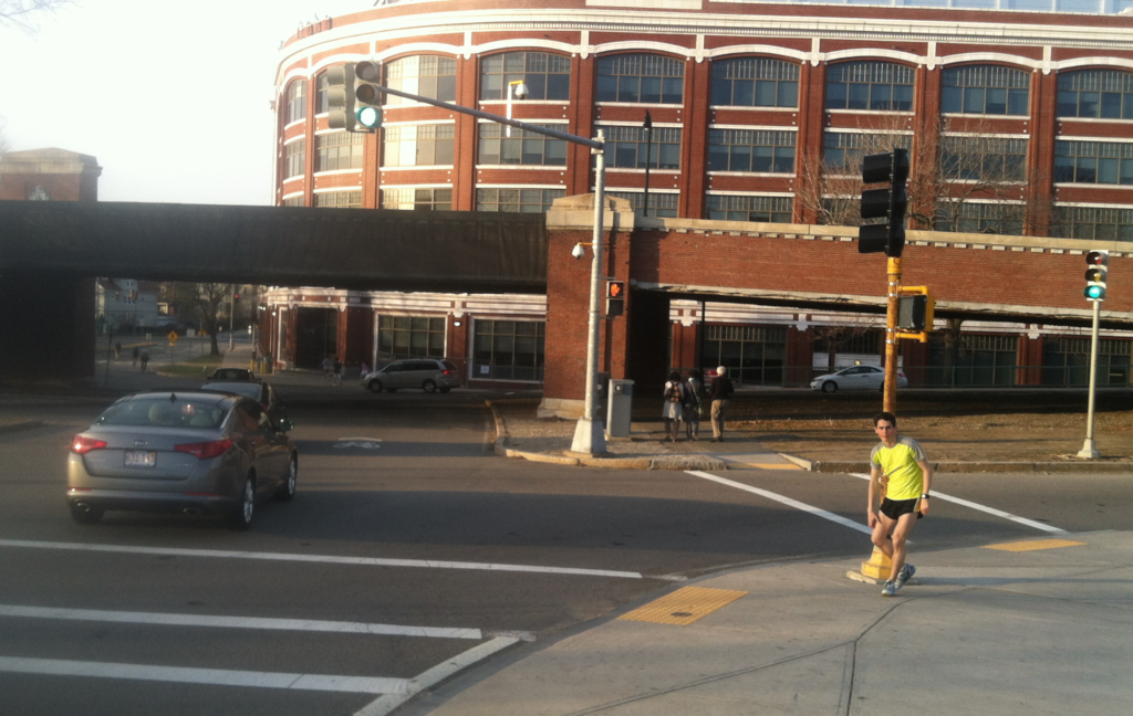
A simple question: What is wrong with this picture?

The answer: the cars have a green light to go straight, but the pedestrians have to wait. This signal is optimized for vehicle movement, at the expense of the safety and convenience of pedestrians. Considering that this is an area with high pedestrian use—at the northern end of the BU Bridge along the Paul Dudley White bike path—it is nonsensical that such priority is given to vehicles rather than pedestrians. The only way to get a “walk” light is to push the “beg button” on either side of the crosswalk—otherwise the light stays at “don’t walk” encouraging drivers to make the turn without looking for pedestrians.

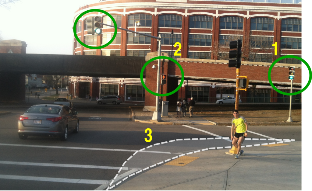
But it’s worse. Look to the right. There’s a second traffic light showing green. Cars driving a downgrade are encouraged to make the turn as fast as possible (the tapered corner doesn’t help), at the expense of the pedestrians. Want to cross? Wait until a red light. Although it’s not like that will even help that much: cars can still take a right on red (after “stopping”).

What could be changed to make this intersection safer?

  1. The once-you’ve-turned light should be removed or relocated. Right now it is too far around the curve. By the time a driver sees it in its green phase, they are already crossing the crosswalk. In its red phase, a driver who had missed the main signal would have already crossed the crosswalk. It could be replaced with a “yield to pedestrians in crosswalk” sign.
  2. The walk signal should be changed to display a “walk” sign with every green phase of the light. This will allow for safer pedestrian movement and will not relegate pedestrians to play second fiddle to automobiles at this intersection. It could be enhanced with conspicuous “yield to pedestrians in crosswalk” signage.
  3. At slightly more cost (the first two items would simply require reprogramming or removing the lights) the curb should be bumped out to create more of a right turn movement. This will require vehicles to slow down as they make the turn to cross the crosswalk, which will allow them to better look for pedestrians crossing from one side of the roadway to the other.

This is traffic calming at its simplest: traffic throughput will not likely be curtailed (the bottlenecks in this intersection are not due to this light, but are at other locations) and it would significantly enhance conditions for more vulnerable road users.

Autopilot and self-driving cars

Every now and again I come upon a self-driving car (or fully automated vehicle, or FAV) puff piece. Here’s Robin Chase—of the Cambridgeport Chases—talking about how we’ll have fully automated vehicles zipping around and shuttling us places in a matter of years. Here’s the AtlanticCities talking about the steps that will be taken to give us FAVs in a very matter-of-fact way. Look, Google has one, right here! And Bridj (a press-grabbing start-up about which I am a tad skeptical—that’s for another day) predicts we’ll have shared, automated vans carting us around in no time. Won’t it be great when we’re all driving FAVs?

I’m skeptical. The main premise of four wheels and an internal combustion engine is 110 years old and hasn’t really changed. But technology is great, right? Surely it will solve this problem. Planes have autopilot, so why can’t cars.

Because planes have pilots, too. Jim Fallows had a piece recently about “what autopilot can’t do.” Autopilot doesn’t land planes, and in very adverse conditions, it can not compensate for things like gusts of winds from the side. The video he shows has pilots expertly guiding planes in at an angle, then straightening out just in time to touch down and not shear the wheels off. This is not something a computer program can do, because it requires a soft touch on the rudder—and knowledge that can’t really be programmed. 99% of the time, autopilot is great. But 99% of the time isn’t enough.

For FAVs, the same issue will arise. Sure, 99% of the time, a fully automated vehicle will do fine. And, yes, perhaps there will come a time when FAVs are allowed to be operated on certain limited-access stretches of roadway. But while it’s easy (well, not easy, but it’s relative) to code a car for the same few situations that come up over and over again, it’s a bit harder to solve the myriad issues that account for the other 1%, such as:

  • a patch of ice
  • a piece of debris
  • a bicyclist darting out between two cars
  • a pedestrian jaywalking
  • the proverbial child running after the bouncing ball
Autopilot for airplanes is designed for the easy-to-solve portions of a trip: the set-it-and-forget-it parts. But it still requires two pilots to keep an eye on things. And that’s on airplanes with triple redundancy built in everywhere. As long as cars ply public roadways and run on an ICE, they’ll need to have a human paying attention to the road ahead.

Most situations can be automated and controlled for. But driving—especially in cities—is not easily automated given a myriad of uncontrollable factors. For those situations, the human brain still is, by far, the most effective tool.

The Pike Straightening in context

Last year, the state announced that it was going to straighten the Mass Pike in Allston. Everyone agrees this is a good idea: it’s an aging structure, it includes far more grade separation than necessary, wider roadways than will be required for all-electric tolling, and a speed-limiting curve. The initial design last year left a lot to be desired: it doesn’t change much of the area, and included big, sweeping, suburban-style ramps to move vehicles at high speeds from the Turnpike to Cambridge Street, and then funnels those vehicles in to the same godforsaken intersection with River Street and Western Avenue that already exists. Apparently it will be updated, but as stated now, it is a wasted opportunity.

This area represents a once-in-a-lifetime opportunity to engage major institutions and infrastructure to connect Boston in ways it has never been connected before. This page previously discussed the various related projects in the area. Harvard realized that a decade ago when they bought all the land underlying the area (MassDOT retains full easements). But there are several facets where a long-range outlook for the area would allow massive redevelopment, a new, transit-oriented housing and employment hub, and dramatic improvements to traffic flow to boot. While little of this may come to pass early on, it is important that construction that does take place does not preclude such improvements in the future.

Image from this post. Read the whole thing.

I’m not the only one who thinks this. David Maerz has a great graphic about how Storrow Drive could merge in and out of the Turnpike, and off of the river, and it’s a huge step in the direction I’m thinking. I assume we came up with these on our own; it’s the right thinking. Hopefully we can convince the state to go in this direction as well.

The long and short of it is that while the project scope may be limited now, nothing should be constructed to preclude future development. The worst thing that could happen would be a highway engineer’s dream ramps, speeding traffic along swooping elevated highways. That may work fine 25 miles outside the city, but it would represent a lost opportunity in Allston.

Decongestion:

While traffic on the main trunk of the Turnpike (100,000 vehicles per day) flows reasonably well, the same can not be said for the ramps leading on and off (30,000 per day). (Traffic counts here) All traffic is funneled through two toll booths (or in the parlance of the Turnpike, “Plazas”) and subsequent sets of ramps. Most of it then goes through a bottleneck. Except for traffic to and from Allston, all traffic to/from Soldiers Field Road, Memorial Drive, Western and River Streets—and by extension Harvard, Central and Kendall Squares and beyond—runs through the intersection at Cambridge Street and the river. Thanks to a series of traffic lights and one-way streets, this ramp backs up to and sometimes through the toll plazas, and because of minimal throughput and merging, often creates delays of 15 minutes or longer. For traffic coming from Cambridge and Storrow Drive, there are similar delays as traffic has to run across the intersection outbound. This ties up in both directions for most busy times of the day.

In addition, these ramps create a horrid environment for cyclists and pedestrians. A relic of 1960s-era planning, Cambridge Street was built like a highway, and pedestrians and cyclists have to cross high speed ramps and then navigate an intersection with long light cycles and few, if any lane markings. Straightening the turnpike without addressing these shortcomings would be a major failure.

Example of a more efficient vehicle route.

Looking further out, however, there is ample opportunity to create additional entrances and exits from the Turnpike, and pull the congestion out of this area. For instance, a set of ramps further west in Brighton would allow traffic from Harvard Square and Fresh Pond Parkway to use the Eliot Bridge and avoid the Turnpike all together. This would remove traffic from this intersection, and reduce travel distances overall. It would also allow better highway access to the New Balance development in Allston, and several neighborhoods which border the Turnpike but do not have nearby highway access. Changes like this are not necessarily directly wihtin the project scope, but they are so intertwined that they should be analyzed along with the straightening itself.

A extension of the street grid (see next section) through the area would also help with congestion, and allow better access to the BU property bordering the rail yard.

Bicycle facilities in yellow:
  • Solid: existing
  • Dashed: under construction
  • Dotted: planned/proposed

Potential highways in orange
Potential green space in Green
Potential street grid in white

Street Connectivity


Allston is currently a black hole for getting from one side of the world to the other. From Boston University to Harvard Square on a bicycle, your options are to use the BU Bridge or Harvard Avenue and the Cambridge Street overpass or a derelict pedestrian bridge. Options by foot or by vehicle are not much better. While concepts include a street grid generally along and north of Cambridge Street, there is the opportunity to connect the streets south to Boston University and Commonwealth Avenue. These would increase bicycle and pedestrian mobility as well as easing the current gridlock at the nearest crossings of the turnpike east and west of the Allston Yard, at the BU Bridge and Harvard Ave/Cambridge Streets. Entrances and exits from the Turnpike would allow for far better connections across this current hole in the system. It would also provide links between much of Boston’s bicycle network, which is one of the premises of the People’s Pike.

Development


One huge issue in Boston is a lack of affordable housing. Housing in Allston, Brighton, Cambridge and the surrounding areas is accessible to jobs by transit and to the nearby universities. The Allston plot happens to be right in the center of three schools: within a mile of BU, Harvard and MIT. While Harvard owns the land, it could provide housing for all three schools, as well as for the population in general. High-priced riverfront housing (especially if the roadways were pulled away from the river) could help to subsidize construction with less lofty views, but still a great location nearby thousands of jobs and educational facilities. Would this be a complete panacea to the housing issues in Boston? Probably not. But the land would be available to add thousands of housing units, many of them owned by colleges for student housing, which would free up some demand in nearby neighborhoods and stabilize prices. It would also provide an area which area which could be very well connected to transit for commercial development as well. By depressing as much infrastructure as possible and decking over it, a large, open area could be available for development.

Parkland


Potential route for Soldiers Field Road
away from the river and new parkland

Right now, the Charles River is lined with roadways for five solid miles from Boston the Eliot Bridge and beyond. On the Boston side, Soldiers Field Road and Storrow Drive leave little room for bicycle and pedestrian facilities between the river and the roadway. In addition, Harvard’s Business School campus is cut off from the river by the roadway, and the advantages of a beautiful riverfront campus are denuded by a four-to-six lane highway. Harvard is obviously a major stakeholder here, but if they were amenable, the highway could be routed west of their campus and the Stadium. This would, if anything, shorten the length of the roadway, and for Harvard, instead of decking over part of Soldiers Field Road, they would have a direct link to the river.

The change would be dramatic. The current underpasses at Western, River and Harvard could be repurposed for bicyclists (a goal of the Charles River Conservancy and many bicycling and pedestrian activists) saving millions of dollars and achieving a goal for the DCR plans along the river. It would also create one of the best riverfront parks in the country. It would increase the value of real estate near the river. In the 1930s to 1960s, we paved along most of our riverfront. This would be a great opportunity to take it back.

Transit


Existing (solid) and potential (dashed) transit.
New stations shown.

Finally, this area is currently reasonably well-connected to the transit system, but it could be dramatically better connected. The state’s 10 year transit plan shows DMUs operating from a “West Station” in the Allston yard area to both North and South stations. This is a fine start. But the opportunities here are endless. Currently, there is a drastic demand for travel between Cambridge and the Fenway/Allston/Brookline/Longwood areas. The 1 and 66 are the top two bus routes the MBTA operates, and the M2 runs from Harvard to Longwood ever 5 to 10 minutes at rush hour, and frequently all day. If there were a better connection, it would be great for jobs access and congestion reduction. And buses currently skirt the Allston area, but better connections would certainly improve the situation.

So a first step would be the DMUs between Allston and the downtown terminals. Further along, the line through Kendall could be improved to allow more frequent service and transit-level service could be provided between 128 and North and South stations, serving the high-density Newton-Brighton corridor and adding more transit choices for commuters along the Turnpike, easing congestion further (and pulling off enough demand to, say, eliminate Storrow Drive west of the Bowker overpass).

In the long run, however, the Allston area provides a dramatic link between Harvard Square and Kenmore and points south. When the Red Line was relocated in the 1980s, the former yard leads to the Cabot Yards (now the Kennedy School) were maintained—the tunnels exist to this day, curving from the Red Line tracks parallel to the bus tunnel. The right-of-way is maintained through the campus (a conspicuous gap between buildings) to the river. While tunneling would be expensive, this is a transit corridor that could connect to Allston (via North Harvard Street) and then across Allston. An initial corridor could connect to the B Line on Commonwealth Avenue via the BU campus, with a connection at the “West Station.” Further along the line, it could be extended (via tunnel—expensively) through the Longwood Medical Area and Melnea Cass Boulevard to the Andrew or Columbia stations, creating the opportunity for a true Urban Ring. Since it connects with the Red Line on both ends, it could use the Red Line rolling stock (which has higher capacity than other MBTA equipment).

Obviously this is a decades-long plan, but the transitway could be at least roughed in in the Allston area (and maybe connected to the Green Line which could have a short A-Allston branch extending in to the Harvard campus) with provisions added for extensions in both directions. Again, this is a once-in-a-lifetime opportunity with basically a blank slate, and it’s much cheaper to build a box now than dig a tunnel under already-built infrastructure.

A lot of these steps are long in the future. However, there is no reason we should construct something now which will preclude this potential in the future.