What, me plan? The case of New Hampshire tolls

Electronic tolling in the United States took a long path to implementation. EZPass was first developed and implemented in the mid-1990s in and around New York City, and began to spread elsewhere. Maine’s not-compatible TransPass system began around the same time, before being folded into EZPass in 2004. Massachusetts implemented the compatible, but differently-named (because, who knows) FastLane system in 1998, which was eventually folded into EZPass. Overall, EZPass-compatible systems stretch from Maine west to Illinois (still called I-Pass) and south to Florida (well, some toll roads in Florida). It is a reasonable example interagency cooperation—or of the size of the New York-area toll structure dwarfing the rest of the market—despite the inherent inefficiency of 40 separate agencies each with their own distribution and service networks.

I guess once the toll-taker jobs started disappearing each state still needed some agency jobs for patronage.

The longtime hold out to electronic tolling? New Hampshire. Maine’s system was in place in 1997, and Massachusetts in 1998. More than half of the system’s revenue is from out-of-state drivers, and the I-95 Turnpike—called the Blue Star Turnpike officially—likely contributes the highest ratio of out-of-state, so most of the drivers on the Blue Star were going from one state with electronic tolling to another through a facility without it. Once Maine switched to EZPass-compatible transponders in 2004, New Hampshire couldn’t even claim that there was a technological reason for the discontinuity.

New Hampshire finally put EZPass on their roadways in the mid-2000s, and phased out the tokens, converted the Hampton toll plaza into a one-way toll with the toll doubled to combat backups by having more lanes open and eventually converted two of the toll lanes into “open road tolling” or ORT, allowing vehicles with transponders to pass through the tolls at highway speeds. It now gives a 30% discount to people who use a New Hampshire-branded EZPass, even if they live out-of-state, leading some drivers (raises hand) to swap between Massachusetts and New Hampshire transponders at the state line.

There was one major problem with this implementation: the highway has four lanes. Even in the earlier days of New Hampshire EZPass use, many turnpike drivers used the electronic system. Yet the roadway was designed such that, if it were operating at or near capacity, the toll plaza would be a bottleneck if more than 50% of drivers were using the transponders, and since its busiest times are when out-of-staters are driving north for vacations from states with higher transponder use, although these less-frequent drivers appear to be less likely to have transponders. So when traffic peaks, the Hampton Tolls are the first place to back up.

Now, I’m not one to suggest that New Hampshire should be building wider or larger highways to combat congestion. Certainly not. But in the case of the Hampton tolls, they didn’t build a wider highway. They built too-narrow of a highway. The roadway is four lanes upstream and downstream of the tollbooths. It’s hard even to believe that it was any more or less expensive to build two through lanes instead of three or four. The gantries were built to allow an additional lane, but there are large barriers between the current ORT lanes and the parallel booth lanes. Maybe it’s cheap to make this change by just moving the barriers, but in that case: why hasn’t it been done? Maybe it’s expensive because it will require work on the base of the road and regrading, in which case, it’s a planning failure. What consultant green lit this?

Why am I bringing this up now? Because I found (thanks to Casey McDermott of NHPR) New Hampshire’s weekly breakdown of toll data. I could write a blog post about the COVID drop off (the much richer data from the tolling facilities in Massachusetts hasn’t updated in a while, so I’m waiting on that), but instead, I want to focus on the percent of tolls paid with a transponder.

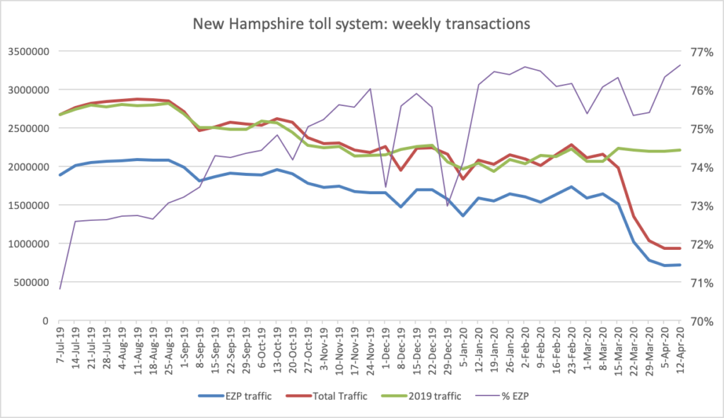
A few things to notice (beyond traffic dropping by two thirds during COVID):

  • Even 10 years after implementation, the rate of EZPass use has been steadily increasing, from 72% in July of 2019 to 77% now. This means that of four lanes of traffic, more than three lanes-worth would be using EZPass.
  • This may be due to seasonality. EZPass use rates are lower during non-tourist times. Rates were lower in the summer, higher in the fall (when more traffic is local) with local minima around the Christmas and New Years holidays.
  • Overall traffic is quite variable, ranging from 2.8 million vehicles per week in the summer to 2 million vehicles per week in the winter.
  • There is a steep drop off in traffic at the end of the summer, a local minimum in early fall, followed by a resurgence of traffic during “leaf season” in late September and early October. Variability for winter weeks may be due to snow storms reducing traffic.

The big takeaway is the first point: three quarters of New Hampshire toll road users are using EZPass, yet the toll booths are constructed such that only half (at Hampton) or two-thirds (at Hooksett) of the lanes are set aside for ORT. In addition to merging and sorting issues (cars on the right have to move left for ORT, and cars on the left without transponders have to move right) New Hampshire has constructed an artificial bottleneck. It was an unforced error in 2010, and, for a decade, it’s increase traffic congestion for no apparent need.

The generous take on this would be that what New Hampshire got wrong, its neighbors, Massachusetts and Maine, have improved on. That would ignore Illinois, which started building ORT gantries in 2004. Maine’s open road tolling north of Portland actually relies on a single through lane, but traffic volumes past Portland are low enough this doesn’t cause backups; its under-construction facilities in and south of Portland will not narrow the roadway through the gantries. And Massachusetts, in a fit of competence, did away with toll collection entirely, becoming one of the first legacy toll roads in the country to go to all-electronic tolling. This would also ignore NHDOT’s 20-mile road widening project now entering its 15th year of construction; while Maine argued about the Turnpike widening for decades, the actual construction was completed in only a few seasons. So I am not inclined to be generous, New Hampshire.

With COVID topping the news and traffic volumes down, of course, congestion is not an issue. But this may be a good time for New Hampshire to take the opportunity to fix a decade-old mistake. And as traffic volumes slowly increase, if nothing is done, there will be more unnecessary congestion on the New Hampshire Turnpike.

Remember: changing road pricing can have unintended consequences

A few years ago, I wrote about how the 1996 changing of the toll structure of the Turnpike in Newton dramatically affected traffic. In that case, changing the toll by $1 created a new calculus where many commuters took an alternate route to avoid the toll, leading to traffic on side roads. The state will soon change the toll structure on the Tobin Bridge, going from $2.50 in one direction to $1.25 in each way. They claim it will be revenue neutral (it will likely be somewhat revenue positive, actually; see below), but there is not talk of the traffic impact, because the amount you’re charging is the same, so it won’t change the traffic, right?

Wrong. There may be a major traffic impact.

First, the revenue projections. It is very likely that revenue will actually go up. Today, it costs $2.50 to go south on the Tobin, and it is free going north. For a motorist coming south on 95 in Peabody, it is usually only 2 to 3 minutes longer to loop around on 128 and 93 versus the trip straight down Route 1. (At rush hour, it depends more on traffic, but the majority of travel on the Tobin Bridge is at non-rush times.) The 128-93 route is about five miles further, but even assuming 50¢ for gas (most motorists don’t figure in the full marginal cost of a mile traveled, many probably discount the extra gas anyway) it is still a saving of $2 for three minutes of time, a rate of $40 per hour. That’s generally worth it.

Which is much of the reason why, in 2015, there were 51,000 northbound vehicles daily on the Tobin, but just 34,000 going southbound. (Some of this may be explained by things like the location of on- and off-ramps and traffic patterns, but most of it is likely due to the toll.)

Equalizing the toll will change this calculus dramatically. Many motorists who had balked at the $2.50 toll may be more willing to part with $1.25 to save a couple of minutes. And while some will avoid the bridge northbound, it will be far fewer than if the toll were flipped and it was charged full rate northbound, and free coming south. Guessing wildly, I’d guess that 5,000 motorists will use the bridge coming south, and 5,000 will abandon it going north. This means a lot of new toll revenue for the state.

Currently, the state collects $2.50 from each of the vehicles using the bridge southbound (we’ll assume that the higher rate for larger vehicles offsets the discounted toll charged to Charlestown and Chelsea residents). With 34,215 vehicles counted per weekday in 2015, this amounts to $85,537.50 in toll revenue. My wild-guess assumption is that there will be 5,000 more southbound travelers (39,215) and 5,000 fewer northbound travelers (46,108), each paying $1.25, for a total of $106,653.75, or an additional $20,000 in toll revenue daily. Even discounting lower traffic on weekends and holidays, this will probably add in the neighborhood of five to six million additional dollars of toll revenue for the state.

The tolls will be fairer and make more sense and raises more money for the state, which can always use more money for infrastructure. This is a win-win …

… unless it has an unforeseen impact traffic. The bridge itself is nowhere near congested, especially coming southbound, where peak-hour traffic counts average just 3000 per hour (1000 per lane per hour), well below the 1500 where congestion begins in earnest (in the chart above, you can see how the northbound traffic levels off at about 4000 per hour, even dipping slightly during the 4 to 5 p.m. peak, which may be due to heavy traffic on roadways accessing the bridge reducing throughput). The issue with more inbound traffic is at the end of the bridge.

Most of the traffic (about 85%) stays on the loop ramp to the Leverett Connector and O’Neill Tunnel. An additional stream of traffic is added from Rutherford Avenue, and there is considerable merging and sorting of this traffic. With only two lanes, this is much nearer capacity; adding more vehicles may create merge traffic which will cause significant backups. The traffic on the Leverett Connector and the tunnel should be a zero-sum game, shifting users from I-93 to Route 1, much like the Turnpike toll removal didn’t necessarily increase traffic, but changed where it got on and off of the highway. Even minor changes can have consequences. This one may work fine. Or it may not.

Still, I’m for this change, as it is sensible policy (even if it might have some unintended consequences). In fact, the Commonwealth should explore avenues to toll all the highways leading in to Boston at a rate equal to the Turnpike. Tolls on the Turnpike are not a detriment to the local economy, which seems fine to be churning alone just fine. And other than federal policy (which may be changing), there is no logical reason why Turnpike commuters should have to pay $5 a day to get from 128 to the city while I-93 commuters get in for free. And while the dollars from the Tobin change are relatively small, charging a sort-of congestion charge for other highways leading in to Boston could bring in big dollars. I-93 could be tolled at $2.50 in both directions from 128 to the city, with a lower toll for Route 2 ($1.25), perhaps waived for commuters parking at Alewife. The harbor tunnel tolls, currently $3.50 one way, could be reduced to $1.25 each way to match the other tolls.

At this rate, and assuming that 10% of travelers would carpool, take transit or use side roads to avoid the tolls (although with electronic tolling, it’s harder to simply avoid a toll booth), this would increase the equity of the transportation system, while at the same time raising more than $600 million annually for road maintenance. Considering the age and state of many of the roadways, bridges and tunnels in the Commonwealth, this money could be spent making sure that the roadways are maintained statewide. Unlike a vehicle mile tax, this is not a new concept; it’s one which has been in place on roadways throughout the Commonwealth for nearly a century (far longer if you account for the 19th century incarnations). And unlike a statewide gas tax, this targets users of the state’s most crowded and overtaxed infrastructure, and may be a factor leading drivers to consider other modes, which often run parallel. The Turnpike users already pay tolls. It’s high time others did a well.

Tolls, traffic and unintended consequences

Back in 1996, Governor Bill Weld wanted to be Senator. John Kerry was running for his third term. Amidst the clash of blue-blooded New Englanders, Weld decided it would be a great political coup to remove tolls on two sections of the Massachusetts Turnpike. So he zeroed out the tolls in Western Mass (which mainly required new tickets—yes, that was pre-EZ-Pass—as the highway still required toll barriers; the tolls were reinstated last year to little fanfare) and nixed the toll in Weston Newton. While the Western Mass tolls were a quiet affair, the West Newton tolls were less so.

Overnight, signs went up: Toll Free. One day when I was biking home from middle school (yes, middle school, and yes, I was a commie bicyclist even then!) I noticed a peculiar sight: a backhoe was tearing in to the old toll booths, and within a few days they were gone, paved over would never be seen again. Of course, this was a transparent political ploy, and it soon surfaced that Weld hadn’t publicly bid the demolition contract but instead given it to a friend. He lost the election by seven points. 
And overnight, he created a nearly-twenty-year-long traffic jam. (Yes, this was predicted by some at the time, although the Globe article is archived so you need a login, and yes, all of this really happened.)

Much of the traffic coming east on the Turnpike originates on Route 128. When the Southwest and Northwest expressways were canceled, the Pike became the only western trunk route in to the city. Up until that point, the toll to access the Turnpike at 128 was 50¢, and in West Newton it was 25¢. Traffic from the south on 128 has little incentive to stay on 128 to the Turnpike, as the diagonal Route 16 is two miles shorter and, even with traffic lights, negligibly slower, especially given the roundabout design of the 90/128 interchange, where Boston-bound motorists drive half a mile due west before swinging back east through the toll gates. Until 1996, there was a 25¢ difference between staying on the highway and taking the surface roads. In 1996, the savings went to 50¢, and when tolls were raised in 2002, to $1.00 (it stands at $1.25 today). This was a four-fold increase in the direct cost savings over those six years, and there was suddenly a much higher incentive to take the Route 16 shortcut and save a dollar.

And guess what happened on Route 16? Traffic tripled, and gridlock ensued. Exit 16—coincidentally, where Route 16 intersects the Turnpike—was never anticipated to be more than a local access exit. It has a short acceleration zone and a very short merge with poor sightlines around a bridge abutment. And it began to handle far more traffic than it had before. (On the other hand, the outbound ramp no longer required vehicles to slow through the toll plaza, and they frequently merged in to Washington Street at highway speed at a blind corner with significant pedestrian traffic.) With more cars coming off of Route 16 rather than the main line, it created a merge which caused traffic back-ups a mile back Route 16, and—given the merge—also backed up traffic on the mainline of the Turnpike. Additionally, drivers who may have, in the past, stayed on Route 16 between West Newton and Newton Corner instead used the free segment of highway, adding to the traffic along the Turnpike and causing more backups at the short exit ramp there. One shortsighted, unstudied policy change changed the economic decisions of drivers on several segments of road, changed the equilibrium, and caused several different traffic jams.

And the state lost money, to boot.

So the new electronic toll can’t come soon enough. It’s too hard to tell if it will rebalance the traffic, or if growing traffic volumes in the intervening 18 years have created this traffic in any event. But it will finally correct a problem nearly two decades in the making by a governor trying to score political points; a problem that never should have occurred in the first place.