Is a part-time bike lane appropriate for the Longfellow?

So far in our irregular series on the Longfellow Bridge we’ve looked at the difficulty accessing the bridge from the south, the usage of the bridge compared to the real estate for each use and how many bikes are actually using the bridge at morning rush. While my next step is to actually go out and count bikes (maybe this Thursday!), I’ve been thinking about what sort of better inbound bicycle infrastructure could be implemented for the bridge.

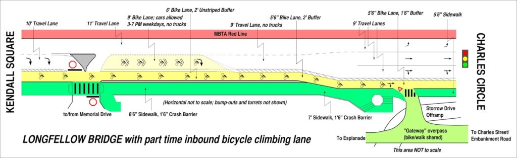
Here’s a graphic. I’ll make more sense of it below (Click to enlarge):

Here are the issues at hand:

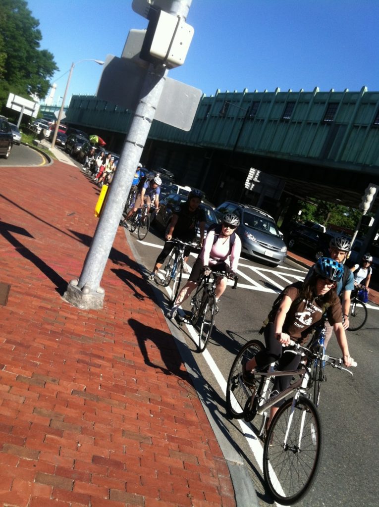
  • Peak bicycling occurs between 7:30 and 9:00 a.m., when bicyclists traveling from Cambridge, Somerville, Arlington and beyond converge on the Longfellow to commute to work in downtown Boston. For nearly any destination in Back Bay and Downtown, it is by far the easiest access.
  • There is much less cycling outbound at rush hour because of mazes of one-way streets combined with heavy vehicular traffic on the other access roads (i.e. Cambridge Street).
  • Thus, the highest bicycle use at any time on the bridge is during the morning rush hour inbound, but while plans indicate a wide, buffered bike lane going outbound, the inbound lane will barely be widened.
  • Since the bridge has a noticeable incline from the Cambridge side, there is a wide spread of cyclist speeds, and it is reasonable to expect cyclists to want to overtake during heavier use times.
  • With improvements to Beacon Street in Somerville as well as the access through Kendall Square, even more cyclists will crowd the bridge in the morning.
  • With the expansion of Kendall Square and its reliance—to a degree—on bus shuttles, it can not be allowed to gridlock over the bridge during peak periods (generally evening rush hour).
In other words, bikes need more room in the morning. And cars need more room in the evening (a single lane on the Longfellow would only accommodate somewhere along the lines of 50 vehicles, and might quickly queue in to Kendall). Luckily, these needs are not necessarily mutually exclusive, and a part-time bike lane would be a possible solution to give bikes the room they need at peak times, while not piling traffic in to Kendall at other times.
In general, part-time bike lanes have been created when parking is allowed at some times and not others (here’s an example from the Embarcadero in San Francisco). The Longfellow is unique in that it has dramatically different usage rates between motor vehicles and bicycles (there are probably twice as many bikes in the morning than the evening, and twice as many cars in the evening than the morning). Bridge real estate is obviously limited—in a perfect world there would be two lanes for traffic and a wide, buffered bike lane, and a pedestrian promenade. So it would be a engineering, logistical and educational challenge to implement such a program.
Here’s the thing: the bridge will be effectively shut down for three years. Traffic will be shifted around for long enough that drivers won’t well remember the previous infrastructure, so it would be a good time (perhaps the only time) to try something drastically new. Here’s a sketch of an idea:

Between Kendall Square and Memorial Drive, Main Street will merge from two lanes to one, to the left. The right lane will be for turns on to Memorial Drive only, and will be set off from straight-ahead traffic with bollards or a median.

Past the Memorial drive ramps:

The left inbound lane is kept at 11 feet and all non-Memorial traffic merges in to it before the bridge. The constriction for the Longfellow traffic is throughput at Charles Circle, so this shouldn’t dramatically affect traffic, especially since Memorial Drive traffic would exit in a dedicated lane. This will allow traffic to comfortably travel in it at all times. The lane would be signed as Vehicle Traffic, All Times. It would be separated from the right lane by an unusual marking such as a double broken white line. 

The right inbound lane should be narrowed to 9 feet in width. Height restrictions (chains hanging from an overhead support) could be hung at intervals to discourage trucks and buses but signage would likely suffice. It would be signed as Bikes Only Except Weekdays 3 PM to 7 PM. No Trucks or Buses. It would be marked with diamonds or some other similar feature as well as “Sharrows” and separated from the bike lane by two solid white lines with no painted buffer in between, potentially with infrequent breaks.  

The bike lane would be 6 feet wide and the two lines would serve as a 2 foot buffer at evening peak. It would be signed as a regular bike lane.

This will extend to the top of the bridge where the grade evens. Beyond that point, there is less need for a “climbing lane” for cyclists, and the bike lane will taper to one, buffered lane. The left lane stay 11 feet, and the right lane 9, but it will be open to cars at all times, with a continued buffered bike lane. Having the right lane closed to trucks and buses will dramatically increase the comfort level for bicyclists who are often squeezed by large vehicles, who will have no business in the right lane.

At the Cambridge End of the bridge, the merge to one lane before the Memorial Drive will funnel all Cambridge-origin traffic in to the left lane (this is the only origin for trucks and buses which can not fit under the Memorial Drive bridges). During non-peak afternoon hours, the Memorial Drive intersection would then join this traffic in a short merge lane after crossing the bicycle facility. At peak hours, it would continue in the right lane. This means that for a truck or bus to use the right lane, it would have to actively change lanes, meaning that even during rush hour, bicyclists would not be pinched by frequent tall tour buses and delivery vehicles. And at other times, most of the origin traffic from Cambridge would already be in the left lane, and only the Memorial Drive traffic—which already stops at a stop sign—would have to be signed in to the lane based on the time of day. The irregular lane markings will clue most drivers in to the fact that there is something different about the bridge, as will signage placed on the bridge approaches.

At the Boston end of the bridge, just before “salt/pepper shaker” the bridge could be widened (for instance, see this older image) to allow bicyclists to stay in a buffered bike lane and cars to sort in to three full (if narrow) lanes. However, two lanes might be preferable to allow trucks and buses to get from the left lane on to Charles Street (or such vehicles could be forbidden from this maneuver and forced straight on to Cambridge or left on to Embankment Road). In this case, enough room for side-by-side cycling in a bike lane—at least 7 or 8 feet—should be allowed (this is not showin the above schematic).

The potential for a flyover bike ramp to the unused portion of Embankment Road should not be discounted, either, as it would siphon much of the bicycle traffic away from the congested Charles Circle area. I called this the “Gateway Overpass” as a lower, gentler and wider bridge could span from the Embankment Road area across Storrow Drive to the Esplanade and allow easy egress to Charles Street across the Storrow offramp. The current bridge is narrow, steep and congested, and provides far more clearance over Storrow Drive than necessary. A new bridge is proposed (see page 10 of this PDF) but I think a level bicycle facility would be very helpful to help bikes avoid the congestion at Charles Circle.

If this project were found to be either dangerous for cyclists or a major impediment to traffic in Cambridge, it could be changed simply by restriping existing lanes, so there would be no major cost involved. If it constricted traffic enough, the lanes could be restriped with a buffer to allow a wider cycling facility inbound at all times.

I think it’s worth study, if not a try.

Hubway + Umbrella: Great Life Hack, or Greatest Life Hack?

As I left a meeting today, a light rain had begun to fall. I wanted to go from Powderhouse Square to the Market Basket in Union Square and the bus there didn’t come for fifteen minutes. The rain wasn’t hard, so I hopped on a Hubway (which I’ve nerded out on before) for the two mile ride.

I had an umbrella (a fantastic Montbell ultralight—less than six ounces and it folds down to nothing) stashed in my bag on the front basket, and as I glided down towards Davis I took it out to see if it would keep me dry (or at least make me look like the world’s lamest Mary Poppins). It sort of did, but got caught in the wind, so I lowered it down on to the handlebars and, miracle of miracles, it nested there perfectly. The drop handle bars and basket allow a small-to-medium sized umbrella to sit on the front of a Hubway bike and, as long as it’s not too windy, keep your legs completely dry from falling rain.

Look, ma! Dry pants!

I had a helmet and rain coat, and with the umbrella and fenders my khaki-clad legs stayed dry. I find that the worst part of riding in the rain is the water shooting off the fender and soaking your legs from below as the rain dampens them from above. With this hack, I was able to cycle in a moderate ran and stay mostly dry. And my stuff stayed dry, too.

At no time did the umbrella try to blow away, and at no time did I feel like I had to tie it down to keep it dry. I biked along at a leisurely pace, and when I got to the rack near the grocery store, I snapped a picture and walked the rest of the way. Would this work in a hurricane? No. But it makes bicycling much more palatable when there’s a light rain coming down. If ever I’m tempted to drive when it’s raining, I now have one less excuse. Especially if Hubway comes to Dana Park (pretty please).

6000 Bikes Per Hour

A few weeks ago, a sea of cyclists pedaled (slowly) through Cambridge. The city has two annual recreational rides, complete with police escorts, where hundreds of bicyclists take to the streets. I took a video of the procession through Inman Square and it got lost in my phone for a while, but recently resurfaced and made it to Youtube.

It’s not that much to watch, unless you really like watching chatty cyclists at low speed, but it is illustrative how space-efficient cyclists are. The video lasts a bit shy of three minutes, and for about 2:30 of that (give or take) the swarm of cyclists passes by. I happen to know that there were about 250 (actually 258, according to the website). But let’s use round numbers—even at low speed there were 100 cyclists passing by per minute.

Which is extremely efficient.

On a freeway, a lane of traffic can only carry at most 2000 vehicles per hour—beyond that the roadway devolves quickly in to gridlock (and the number of vehicles drops). Yet one lane of bicyclists can accommodate three times as many people—you’d have to have three or four people in every car on a freeway to have the same level of service. Want to fill buses? Fine, but you better be able to get a full bus through every 30 seconds to match a lane of cyclists. Rail can surpass this capacity—at rush hour the Red Line in Cambridge peaks over 10,000 people per hour, and some lines in New York go past 20,000—but you need a bit more infrastructure to run such rail routes.

Since bicycles take up far less space than vehicles, they use road space much more efficiently than vehicles. Even if a rate of 6000 per hour necessitates a police escort, it’s still a testament to the efficiency of the bicycle.

Longfellow Bike Traffic update

I came in this morning across the Longfellow. As I jockeyed for position through Kendall, I knew it was going to be busy on the bridge. I’ve seen ten bicycles per light cycle on the bridge, but today the lane was chock-a-block with bikes all the way across the bridge. With minimal auto traffic, faster cyclists were swinging in to the right lane and passing slower cyclists. And when we got to the bottom, well, it was quite a sight.

I quickly hopped the sidewalk to take a picture. By my quick count, there were 18 cyclists in line waiting for the light to change at the bottom of the bridge. Last month, I’d assumed 10 bicyclists per light cycle, which would equate to 360 per hour. At 18 bicyclists, this is an astounding 648 bicycles per hour, or one every six seconds. That’s nearly as many vehicles as use the entire bridge in the AM peak (707). And this is despite the fact that the Longfellow is a narrow and bumpy bicycle facility.

So it is a shame that the current plan for the bridge allocates just as much space to vehicles, and does not appreciably expand the inbound bicycle facility. As we crossed today there were few vehicles, but bicycles could barely fit in the lane. Since the bridge hasn’t been rebuilt yet, there is still time to advocate for fewer vehicle lanes (one lane expanding to two would be mostly adequate) and a much wider bike lane allowing for passing and a buffer.

The current bicycle counts are only for the evening commute where, as I’ve pointed out before, it’s much harder to get to the Longfellow due to traffic, topography and one-way streets. I think it’s high time for a peak morning bike count on the Longfellow. And time to suggest to MassDOT they reexamine the user base for the roadway before it gets reconstructed and restriped.

Plus, if we have 650 bikes per hour using the current, subpar facility, imagine the bike traffic once the lane is wider and well-paved. To infinity and beyond! Or, at least, to 1000.

Low-capital, bridge-based tidal power

This past weekend took me on a bike ride across Portland, Maine’s Tukey’s Bridge. Thanks to the vagaries of the bicycle network in Portland (another long post), we looped under the bridge before crossing over it.

As we did, I noticed the tide going out. Portland’s back cove is not a particularly large body of water, it’s about one square mile. Nor is it deep—at low tide it mostly empties in to the Atlantic and becomes a large mud flat. But all the water has to go somewhere, and it certainly does: it flows under Tukey’s bridge. Portland’s tides—around 10 feet—are relatively large but nowhere near those up in the Bay of Fundy. But where the water rushes in and out of the Back Cove, there is a decent current which occurs several hours each day. Every day.

The flow is increased by the current incarnation of the bridge, which is built on fill to narrow the mouth of the cove considerably. So now the square mile of water has to flow through an opening only about 250 feet wide. There’s power in that water, and while it’s certainly not megawatts, the infrastructure seems to be such that you could pretty easily install a small-scale tidal power system to take advantage.

Tukey’s bridge has two main passages. What if, in one of them, you installed a paddle wheel contraption between the supports with a generator on one end? There is no need to worry about building supports; the bridge abutments are in place. There is no worry about navigation; small boats could easily pass through the other half of the bridge. There would have to be some sort of floating barrier to keep boaters from running through such machinery, but that would be doable. The paddles would not reach the floor of the cove, so they wouldn’t interrupt whatever ground fisheries there are there. The generator could be housed on the bridge abutment out of the water, which would keep it out of corrosive salt water.

So if we assume that all the agencies (and I’m figuring NOAA, Army Core, the DOT and others would be involved) could be satisfied, would this work as a demonstration project? Could it conceivably have a payback time that would make it economically feasible? It seems like a low-cost project. All you’d need is a generator, some power lines and some concrete to anchor it to the bridge.

Or do I have the physics of it all wrong anyway?

Mapnifiscent Needs More Bikeshare

There’s a great site called Mapnifiscent. You put in a location, it calls up the Google Maps GTFS API (probably), and it tells you where you can get in n minutes. What if you have a bike? If you have a bike, you can change the settings and say “I have a bike!” and it will factor that in to the equation. (One minor point of contention: it assumes 3 mph straight-line for walking, but just 6 mph for bikes. 3 mph in a straight line for walking seems quite fast, as it probably equates to 4-5 mph when roads are taken in to account. 6 mph seems slow, although when I calculated Hubway speeds it is actually a pretty good estimate for straight-line urban biking speeds.)

What if you have a Bike Share fob? Well—that’s anyone’s guess. A great new feature would be for Mapnifiscent to scrape the XML feed off of bike share sites (for instance, here’s Boston and DC) and plug locations in to their formula. It could then offer an option “are you a Bike Share member” which would allow estimates based on combined transit-bike share-walking trips; and show how bike sharing can enhance transit by expanding access. Because, let’s face it: you don’t always have a bike with you. And sometimes it’s not allowed.

Hubway Expansion Station Locations Not Always Optimally Located

Boston Bikes and Hubway are in the midst of a public input process for adding shared bicycle stations to several neighborhoods in Boston. Not only are these additions welcome for the general public, but the city has decided to use a local start-up, CoUrbanize, to solicit input. CoUrbanize has a map- and tag-based comment database, and seems like a good, simple platform in the often-confusing public comment sphere. So all systems are in place to get some good comments, and get the stations on the street, right?

Not really, because instead of putting the stations in thoughtful locations where they will do the most good, they are scattered across the study area and located in places where they make no sense (while leaving out obvious locations like major commercial corridors and transit stations). So instead of having a good discussion about the merits and detractions of various locations, the public is now discussing how some of these locations make no sense at all as bike sharing locations (at least in the current iteration of bike share), and why other, disparate locations, would work much better. This seems less productive than would be desirable.

An issue seems to be that the station maps were created to cover as much of the map as possible without much thought to whether the locations were best of bike sharing. This seems like a political play to keep constituents happy, but seems to assume that constituents will be content if their neighborhood is covered by a circle on a map, but not care whether or not there is a useful network of shared bicycles. The Jamaica Plan expansion—the largest of the three proposed—is a good example of how this plays out. Most of the study area is in or near a circle buffered around a location. However, the way in which the stations were placed means that there are no bikes at any Orange Line station, and that the southern portion of the Centre Street business district is underserved as well. For anyone with more than a passing interest in Hubway—and most public commenters likely fall in to this camp—the illogic of some of these station placement is obvious.

There are three neighborhoods being studied right now: Jamaica Plain/Roxbury, South Boston and Charlestown. All of them seem amenable to bike sharing. Yet several of the locations chosen in each bear little resemblance to successful bike sharing locations. Let’s review several important factors in siting a bike share kiosk, which I’ll define as

The Five -tions of Bike Sharing

  • Population density (there needs to be someone to use it)
  • Destination (it needs to be somewhere people want to go)
  • Elevation (bike share locations on hilltops require frequent rebalancing as people take advantage of gravity in one direction only)
  • Connection (they need to be part of a dense network)
  • Transportation (bike share needs to complement existing transportation infrastructure)
While these are certainly not the only factors necessary for a successful bike sharing system, they are quite important. The proposed locations, in many cases, fail one or more of these tests. In addition, logical, and in some cases obvious, locations were overlooked. It certainly seems that they were chosen not to become part of the existing network, but instead to cover the map. This may be an unfortunate part of the planning process, but in this case it seems to just gum up the works.
Here is some short commentary on the locations:
Jamaica Plain / Roxbury is a fertile location to grow Hubway. There is significant existing bicycle infrastructure, good transit and density, and a burgeoning bicycle culture. A logical system would follow existing transit corridors—Centre Street, the Southwest Corridor (transit and bike path) and Washington Street—in JP, and similar corridors in Roxbury. (I will admit that I know less about the transportation infrastructure in Roxbury than in JP.) Instead, locations are put in some rather inconceivable locations:
  • JP-1 fails due to its location atop Mission Hill. Which is steep! It has population and destination, but would likely require frequent balancing as riders took bikes down the hill but walked up. This would be better moved to the VA Hospital on South Huntington or to Jackson Square, which inexplicably falls outside any of the circles, despite being a major transit hub with significant new development taking place.
  • JP-2 is a logical location, at a business node on a dense transit corridor.
  • JP-3 makes no sense and fails on all five of the -tions above. It is in a relatively sparsely-populated part of JP, away from any transportation infrastructure and high up on a hill. In addition, the only way to access the rest of the proposed and existing network is by navigating the bicycle-unfriendly Pond Street-Arborway corridor. This location will certainly not come to be any time soon, and it’s disingenuous to propose it.
  • JP-4 lies on the Southwest Corridor but is, for whatever reason, halfway in between the Green Street and Forest Hills Orange Line stations. Perhaps it would be a good location in the future, but the first priority should be locating bikes at the stations themselves. Furthermore, there are no locations anywhere near Centre Street through the heart of Jamaica Plain, and this location is about as far from Centre Street as any location along the Southwest Corridor.
  • JP-5 is at Upham’s Corner in Roxbury and is a decent location for a station, although it is somewhat far from other locations.
  • JP-6 is a good location in Egleston Square, but again suffers from the fact that there are no nearby stations, especially along the Orange Line. Egleston was once an elevated station, and Hubway could be a good resource for getting to and from the current Orange Line stations, but if the Orange Line is eschewed, it loses some usefulness.
  • JP-7 is similar to the location above, although at least closer to the current Hubway station at Roxbury Crossing.
South Boston is another good location for bike sharing. It is quite dense and located in close proximity to the Downtown area, but lacks rapid transit except on the western fringe. One issue is that it is surrounded by three sides by water, so connectivity to the rest of the system is a bit of an issue. And while the three stations proposed do not provide coverage for the whole of the neighborhood, they do not fall as far short as some of the locations in Jamaica Plain. It helps that there are existing Hubway stations at Red and Silver Line rapid transit stations on the north and west sides of South Boston, so these stations can act as feeders to there, and to downtown Boston as well. I don’t know Southie that well, but this chart (from Southie Bikes) is a great representation of why Hubway should do quite well there.
Charlestown‘s main issue is that the proposed stations do not complement the existing stations in Charlestown that well—let alone the rest of the system. (NB: there is a new station at the new Spaulding Hospital not shown on this map.) C-2 is a logical spot at the Charlestown Community Center. But C-1 is located between two existing stations. And there are no proposed locations at either the Community College or Sullivan Square Orange Line stations, or logical connections to the Hubway locations in Cambridge or Somerville. While C-3 is labeled as “Sullivan Square,” it is quite a distance from the actual Sullivan Square MBTA station. As the roads in Sullivan are redesigned and as the area is (hopefully) developed in to something more than an array of highways and parking lots, the station may be differently located. But for now, it should be located at the MBTA station, where it can provide connectivity not only to the new and existing Charlestown stations, but to Somerville as well.
It is good to see the City partnering with CoUrbanize to invite public comment for these location, and the comments—some of them my own—have certainly hit on where these stations should go. Hopefully the Hubway expansion steers clear of some of these less-than-desirable spots. Luckily, the stations are portable and easily moved, so, unlike most infrastructure, the system can be rejiggered if it is not optimally sited at first. But it would be even better to have picked better locations from the outset.

Poor signage harms viability of the temporary cycletrack in Lexington

Two cyclists correctly using the temporary “cycletrack” along
Massachusetts Avenue in Lexington.

Biking through Lexington a few weeks ago, I noticed that the Minuteman Bikeway was set to close for most of May for construction work related to a collapsed culvert. And at an opportune time: the first day of construction would coincide with Bay State Bike Week‘s start, and it would last through the rest of the month, Memorial Day included. The Minuteman is certainly a recreational asset, but is also heavily used for commuting; the site of the construction is only five miles from the Alewife MBTA station, where many cyclists transfer to the Red Line or other bicycle facilities.

The only logical detour? Massachusetts Avenue, a.k.a. Routes 4, 225 and 2A. In other words, it’s not a quiet country lane. While some cyclists are comfortable riding the road (and it can be faster cycling than the bike path), many are not. Ideally, there would be a detour around the construction work. But with a narrow right-of-way and heavy construction equipment, this is not possible. So the town of Lexington, to its credit, did something remarkable: they banned parking along Mass Ave and “barreled off” a lane of traffic to create a contraflow cycletrack for a half mile around the closure. As far as I know, it is the first such facility in the state.
And if you want to see it, you better act fast: it will be gone in two weeks.
As well-intentioned as this temporary infrastructure is, the communication to the public could be better: signage both at the site and even online is confusing to cyclists who will already be thrown out of their comfort zone. The crux of the issue is that when you are implementing a new and different infrastructure plan, you need to be clear to the users what they should do. Unfortunately, both signage at the start and end of the lane and at the project’s website (description and sketch; both pdf) is ambiguous, and thus users were unclear as to how to traverse this section of roadways. It seems that highway engineers created a good plan, but the signage was not properly thought through and vetted. 
According to the detour notice (pdf), the following detours occur:
  • Westbound bicycle traffic will take a left on to the Seasons Four driveway, and a right on to the Mass Ave sidewalk, following the sidewalk to Woburn Street and taking a left to get to the trail crossing and proceed up the trail.
  • Eastbound bicycle traffic will take a right on to Woburn Street. It will then turn left across Woburn Street and proceed on the far-left (north) side of Massachusetts Avenue between a row of barrels and the curb—this is the (temporary) protected, contraflow cycletrack. At the end of this facility, they will take a left on to the Seasons Four driveway, and proceed as normal along the path. 
  • Any cyclists who wished to use the roadway along Mass Ave should use the traffic lanes as usual but should note that lane width will be constricted by the construction.
In other words, a cross-section of Mass Ave looking westbound would look something like this:

Simple right? Well, not really. Here are the problems with the communication:
  • The project notice is buried on a town website. It’s easy enough to find with a Google search but not well publicized. Once you find it, however, it is a poorly-formatted word-doc-turned-PDF. I don’t want to toot my own horn (or, pardon me, ring my own bell), but the bulleted section I wrote above is much more informative than trying to parse the information from this document.
  • The sketch which accompanies this notice (but is not linked from it) is clean and simple, but unfortunately leaves out important information to show users how to use the facility. It shows what appears to be the front of a car in the westbound travel lanes, when in fact this should be the rear of a vehicle. This is a fine engineering mock-up, but this is a case where more detail is necessary. It also is too simplified to show the direction of travel, and would be well-supplemented by an overhead sketch as well. It even lacks a proper title, such as “Mass Ave looking westbound” for user orientation. You certainly don’t want information overload, but in this case, important information is left out.
  • The signage onsite is abundant, but lacks important information. In a case such as this one, it is not enough to use uniform highway signage: you are dealing with a different user group, and with a situation which is unique. And even then, the signage is ambiguous. Imagine showing up as a cyclist and trying to make heads or tails of the picture below. Kind of difficult.
  • The written sign shows a picture of a bicycle and pedestrian (fine) and then the text “Temporary shared use trail. Keep right.” Keep right of what? Is this referring to the sidewalk or to the “cycletrack” lane? Does it mean “keep to the right of the sidewalk” or “keep to the right of the cycletrack” or “of the sidewalk and cycletrack, use whichever is furthest right”? 
  • Good idea, poor signage. This sign makes very little sense.
    Do they mean keep to the right of the on-street lane, or
    keep to the right of the sidewalk? Who knows!
  • Below this sign is a which shows two directional arrows (which bend for no particular reason) around a center island. This is also very ambiguous. Does the island refer to the area between the sidewalk and the “barreled off lane”? Or does it refer to the barrels? Is it telling westbound cyclists to use the “cycletrack” and eastbound cyclists to use the roadway (presumably with traffic on the other side)? Coupled with the signage above, it is no closer to making any sense.
What it needs is more of a cross-section, with words and pictures (see above). Yes, it might be a larger sign, but it would also make it much clearer who was to use the trail, and where. Many trail users take the path daily, so a clear sign on the first day would allow them to properly use the facility during the entirety of the construction. This was, unfortunately, not the case.

As for the sketch, a few minor tweaks could make it more usable. Here is the original sketch, and below my retouched sketch with some annotation regarding changes. It’s still not perfect, since it doesn’t show the whole road, but it at least leaves less room for confusion and interpretation.

Site/app idea: Citizen Summons

I just almost got killed by taxicab. Again.

This is an exaggeration (I was able to brake in plenty of time after the cab cut in front of me, and then called me and the female coworker I was biking with faggots, because yeah that makes sense), but not much of one. I’ve found that taxicabs in Boston are frequently the ones hurling invective at cyclists, blocking bike lanes, dooring cyclists (oh, no, wait, the City found that), failing to yield to pedestrians, driving with their lights off at night, and generally driving in ways that endanger the public, and especially vulnerable road users.

And while every car has a license plate, cabs are particularly well-adorned with identifying markings: they have the medallion number on the front and rear, and frequently on top of the cab, and their license plate also frequently matches the medallion. In addition, taxicabs have (or at least should have) more scrutiny regarding their driving habits, as they are on the road constantly, and have more of an opportunity to be the cause of accidents (or conversely, by driving well, part of the solution). Driving a taxicab is certainly a difficult and low-paying job, but that is no reason that taxicab drivers should not be safe and courteous. With thousands of taxicabs hurtling around the area, there are certainly dozens of near-misses a day, where dangerous, reckless and even malicious behavior by a taxicab driver results in a situation where a vulnerable user is put at risk. Yet there seems to be no easy way to report these behaviors, and therefore there is little accountability.

In other words, there is certainly not an app for that.

Yet.

So here’s the idea: a website and app that would allow for the collection of data by bicyclists, pedestrians and other standers-by about the driving behavior of taxicabs. This would include a variety of features and the data could be used in several ways:

  • The data from this could be used to match poor behavior to certain cabs or operating companies, as well as to find particularly problematic locations. 
  • The program could easily send reports to the various taxi licensing agencies in local cities and towns, and to the appropriate police contacts. 
  • It would allow citizens—the ones who are almost bumped when cabs pull in to crosswalks at red lights, or the ones who see cabs lined up neatly in bike lanes awaiting fares or nearly mow down pedestrians because they can’t be bothered to turn their lights on at night—to easily send a report to the right authorities. 
  • It would allow anyone interested to view reports and find dangerous areas or medallions with particularly abhorrent safety records. 
  • It could be scaled in to a full-scale reporting system based on license plates, and focused on dangerous urban driving habits. It’s one thing to yell at the guy who honks at you and then cuts you off. It’s another to publicly shame him.

Cabs in particular seem to operate with some amount of impunity from police enforcement, but that’s no reason we shouldn’t try to gather data and hold them accountable. Plus, such a site could also allow bicyclists, pedestrians and even cab passengers to laud good driving in cabs which were courteous to bicyclists and yielded right-of-way to pedestrians in crosswalks. If nothing else, we—people who walk and bike—account for much of their customer base. We should demand accountability.

If anyone is interested in helping set this up, let me know. I’ve created some simple user-generated content sites (this and this), but this might be a bit beyond my technical expertise.

The one rule I always follow on a bike: Yield to Pedestrians

It’s big bike time, with Bike Days/Weeks/Months sprouting up across the land (some are in June; Minnesota moved theirs after we all froze our behinds off in 2009). And it’s time for bellyaching about bike sharing in New York, apparently. Oh, and for arguing about whether or not cyclists should have traffic laws enforced to the same degree as motorists.

I fall in to the “not” camp, with several exceptions. This is mainly because bicyclists and motorists are orders of magnitude apart in terms of kinetic energy, and thereby damage. Consider:

Bicycle:
Average weight (rider, bicycle, accessories): 180 pounds
Average speed (in city riding): 12 mph
Top speed (in city riding): 25 mph
Average potential energy: 1175 joules
Top potential energy: 5099 joules

Automobile:
Average weight: 4000 pounds
Average speed (in city traffic): 25 mph
Top speed (in city driving): 45 mph
Average potential energy: 113310 joules
Top potential energy: 367120 joules


In other words, the average vehicle has—give or take—100 times more kinetic energy than the average bicycle. I think we’d all agree that if the fines fit the potential kinetic energy (they’d be akin to jaywalking fines, which are $1 in Boston and $2 in New York) they’d be tolerable, if laughable. (And this page is on the record as being opposed to the concept of jaywalking being illegal.) But increasingly, policies towards bikers are moving in to the “fine first, ask questions later” camp.

When it comes to red lights and stop signs, the only person a bicyclist is really endangering is him or herself. No one has ever heard about a bicyclist running in to a vehicle and injuring the occupants inside. If I go through a red light (I should say “when …”), you can be sure I’ve checked the intersection to assure that it is clear of all traffic. And much of the time in such situations I am going through so that I can get on to the next stretch of roadway ahead of—and visible to—traffic behind me.

But the one traffic rule I always do my best to follow? Yielding right-of-way to pedestrians. First, it sets a really good example. Drivers have a tough time being all high-and-mighty when they blow by a cyclist who’s stopped to yield to a pedestrian (especially when said cyclists then meets them at a red light and chastises them for their behavior, but I digress). But it’s also important because pedestrians are, in relation to cyclists, orders of magnitude less energetic. In the vulnerability hierarchy, they have much less ability to cause damage:

Pedestrian:
Average weight: 150 pounds
Average speed: 3 mph
Average potential energy: 61 joules

Here’s a simple Excel chart to illustrate (Except that the top blue bar should be about half-again as long, it broke Excel. Well not really, but it’s illustrative.):

It’s not the same differential: a bicyclists only have one order of magnitude more energy than a pedestrian; vehicles have two more than bicycles (and three more—more than 1000 times more—energy than a walker). And while it’s rare, bicyclists have killed pedestrians. (To be fair, the cyclists are generally injured in such accidents, which rarely happens when a car does something like plowing through people on to a crowded sidewalk.) But when I’m cycling, I always try to stop for pedestrians.

Am I successful? Most of the time. There are times when I’m paying too much attention to traffic and don’t see the pedestrian waiting to cross. There area few times—and I feel bad about this—when I’ve had a close call with a pedestrian walking through stopped traffic as I passed on a shoulder or a bike lane (I usually try to apologize, something difficult to do from a vehicle). But much more often, I slow down, and wave a pedestrian across. Quite often, they are surprised at the courtesy, even though they have full right of way. I often extend my arm out to warn passing cars to slow down, and have more than once weaved in front of a car to get them to slow down.

From a practical standpoint, I can usually keep enough momentum that I don’t come to dead stop, since once the pedestrian clears my bike I can start moving again (and since I can bob and weave around the pedestrian with more ease than, say, a six-foot-wide car). From a bike advocacy standpoint, it shows courtesy amongst bicyclists to more vulnerable users. (When I see a guy in a full kit on a $4000 carbon frame whipping by pedestrians in Cambridge, I get upset; I’ll defer to the inimitable Colin on this.) And from a safety standpoint, it is safer for cyclists and much safer for pedestrians.

So for red lights for me? Stopping is optional. But crosswalks? It’s mandatory.