MBTA ridership and demand elasticity

This spring, I wrote about how the MBTA’s fares are really not that high. Fares went up on the order of 20 to 25%, and the T apparently expected ridership to fall by 5% or so. The numbers are in for the first month and while ridership did fall (the first decline, year-over-year, in 14 months), it was off by less than 1/10 of 1%.

There’s a local company which builds pricing software which is not surprised. They studied the base transit fare and calculated as long as it stayed under about $2.75 there would not be a major impact on ridership. Demand for transit is rather inelastic—people have to get to work—and they’re willing to pay an extra 60¢ a day (or $11 per month) in order to get to a job which pays many dollars per hour. For the average subway commuter, it’s still far cheaper to pay $70 for a monthly pass than to pay gas, tolls and (especially downtown, or in Kendall or Harvard) parking.

What’s interesting is where ridership fell. I expected that the increases in the cost of Commuter Rail to be a detriment to ridership. While transit and bus rose by 17% and 20%, commuter rail fares rose by 25-30%. And with higher fares to start, the nominal increase was $1.25 to $2.25. For monthly passes, which now range from $173 to $314, the increase in fares ranges from $38 to $64, which is not chump change. Commuter Rail customers are more likely to own cars than bus and transit users, and there was a lot of hand-wringing that commuters would abandon the rails and drive instead.

But that hasn’t happened. Even with lighter summer traffic, commuter rail posted gains. So did buses and boat traffic. The only declines were on The Ride (where fares doubled*) and on the Subway. Commuter Rail ridership is up. But the subway, where fares rose by a quarter and a nickel, is down.

However, the more I thought about it, the more it makes sense. While the subway prices stayed well within a range where they won’t have a major impact on demand, there is enough elasticity in supply to allow people to utilize other options. For most Commuter Rail riders, the trip is more than 10 miles and their only other option is driving, which is more expensive and subject to the whims of traffic. The cost of driving might be somewhat less marginally more, but it’s still more. So the supply is quite inelastic—even with fare increases the train is still cheaper than driving.

For subway riders, it’s a different story. Except for the Riverside and Quincy lines, most of the T’s ridership is concentrated within about 6 miles of downtown. Many subway riders have a commute which is only three or four miles long. The supply here is not constrained to transit or driving, but adds walking and cycling to the mix. With a mild summer (June was 1 degree below average, July and August 2 above) and expansion of bike sharing, as well as at-capacity rush-hour trains, it’s quite possible that many commuters looked at the fare hike and tested the elasticity of the short-distance travel supply. And that people looked at a mile-and-a-half ride on the train and decided to save $2 and take a half-hour walk. The price for walking or biking is essentially zero, so commuters were able to overlook the inconveniences of these modes due to the price savings. In other words, they pumped up their tires or put on their shoes.

Come winter, when it’s cold and rainy (or, like in 2011, snowy) these new riders may stream back towards the turnstiles (or, uh, Charlie Card machines). In any case, I doubt the drop in subway ridership is due solely to the rise in prices as much as it is due to riders exploring other options.

* I am torn how to feel about The Ride fares. On the one hand, paratransit is a lifeline for many disabled and disadvantaged groups who would otherwise not be able to get around without it. On the other hand, it commands a subsidy on the order of $40 per ride (if that was the rate of subsidy for all MBTA riders, the annual subsidy would be on the order of $15 billion per year—the cost of one Big Dig), and its ridership is growing exponentially. Paratransit is an important government service, but because it is shouldered by the T, a service for a few thousand riders a day is subsidized heavily by over a million other riders. A good solution, perhaps, would be sequestering funding for The Ride and funding it separately from the T at large.

How high are MBTA fares? Not.

According to the news, Occupy Boston has a new target: the MBTA. This is wrongheaded. They should protest the crawl with which the legislature is able (or unable) to make changes to the T’s funding mechanism, the debt burden shouldered by the agency from the Big Dig and myriad other poor decisions by the state and by the T in the last ten or twenty years. But protesting a modest fare increase? Not helpful.


Back in January, when the draconian proposals came out, my reaction was “well it must not be as bad as last time—then they were threatening to shut down commuter rail at 7 p.m.” Because of intransigence on the part of the legislature, the T has to threaten huge cuts, and then make smaller ones, so it’s a better pill to swallow. This time, at least, people seem to realize it’s a problem. Whether the legislature will act is another question all together.


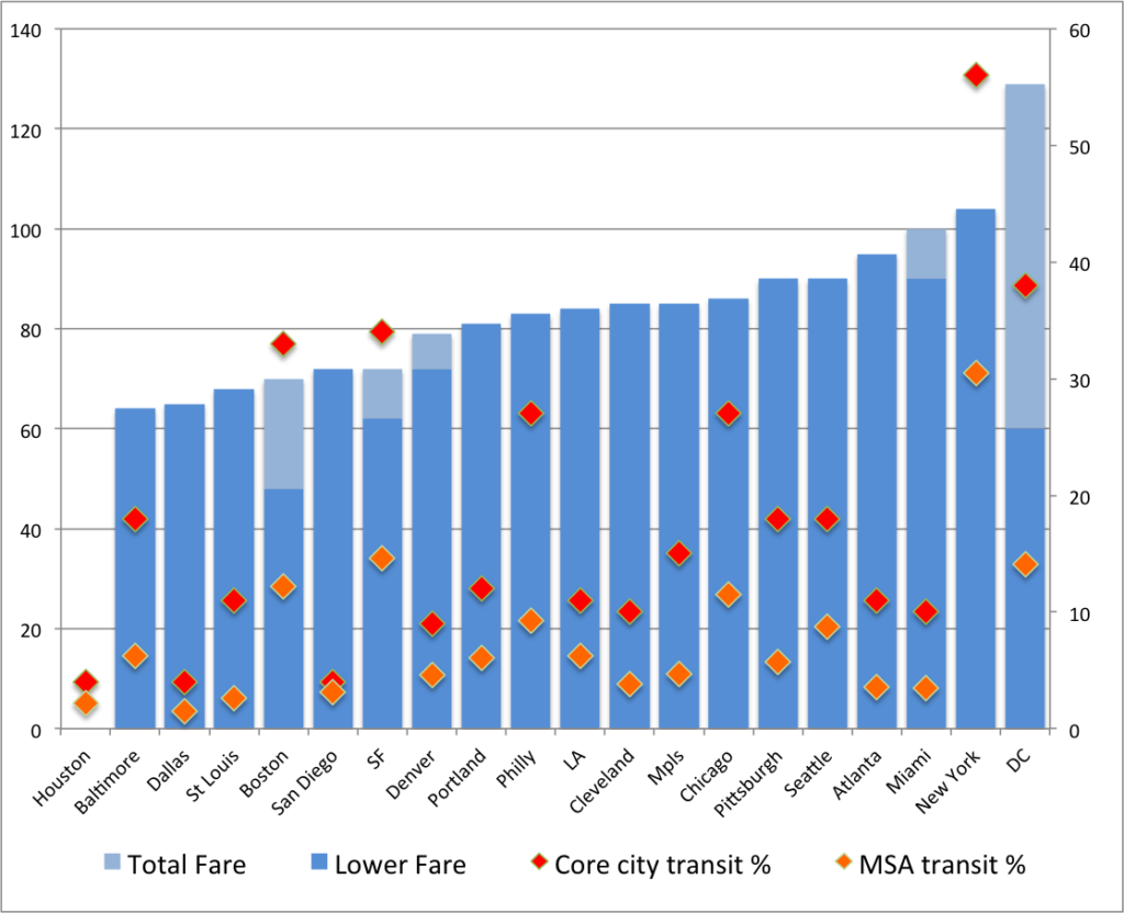
In any case, the T will be raising fares to $2. Monthly passes will rise to $70. This is what the Occupy folks are protesting. And, well, this is really not a big deal. Look at other cities fares:

(“Lower Fares” are shown where there is are multiple monthly pass levels except those based on peak and off-peak fares. Notes: Houston has no monthly pass system. Boston has a $48 bus-only pass, San Francisco’s higher fare allows in-city travel on BART, Denver sells a year of transit passes for the price of 11 months, Miami gives a 10% discount for group purchases. Washington DC has no monthly passes, but a $15 weekly bus pass and a $32 weekly Metro pass allowing fares up to $3.25, which covers travel within the city limits.)

Only two cities have lower fares than Boston, and neither of these has a comparable level of transit. San Francisco does sell a cheaper pass for non BART-users, but those are confined to MUNI lines which are, well, not particularly speedy (the longest MUNI lines are about the distance from South Station to Alewife, but they take more than 22 minutes to complete the route). If you look at the “Big Six” cities with MSA transit use over 10% and center city transit use over 20% (Boston, SF, Philly, Chicago, DC and New York), the average monthly pass is about $85. DC has no real monthly pass option. And New York tops out over $100. Of course, their trains do run all night.


Here is another way of showing that the MBTA fares aren’t that high—looking at fares for major transit systems through the last 100 years in nominal and current dollars.

{“dataSourceUrl”:”//docs.google.com/spreadsheet/tq?key=0Aq40hr6FfrocdEk4Q21pS3V2eFVGeUw4NXVYdTBOMVE&transpose=0&headers=1&range=E1%3AO102&gid=0&pub=1″,”options”:{“vAxes”:[{“viewWindowMode”:”pretty”,”viewWindow”:{}},{“viewWindowMode”:”pretty”,”viewWindow”:{}}],”series”:{“0”:{“color”:”#1155cc”},”1″:{“color”:”#6d9eeb”},”2″:{“color”:”#cc0000″},”3″:{“color”:”#ea9999″},”4″:{“color”:”#ff9900″},”5″:{“color”:”#f9cb9c”},”6″:{“color”:”#38761d”,”lineWidth”:4},”7″:{“color”:”#00ff00″,”lineWidth”:4},”8″:{“color”:”#999999″},”9″:{“color”:”#cccccc”}},”useFormatFromData”:true,”booleanRole”:”certainty”,”curveType”:””,”height”:333,”animation”:{“duration”:500},”legend”:”in”,”theme”:”maximized”,”width”:600,”lineWidth”:2,”useFirstColumnAsDomain”:true},”state”:{},”chartType”:”LineChart”,”chartName”:”Chart 2″}

I left out DC (which has distance-based fares) and SEPTA (I couldn’t find fare history data for Philly) and threw in gas prices for fun. Note that the T has generally been about the same price as MUNI in San Francisco, and cheaper than Chicago and New York. (Except from 1920 to 1950, when Boston fares were a dime, and New York was a nickel.) The transit agencies all raise their fares to cope with increasing prices. And while the T has never hit the two dollar mark before, unless there’s deflation this year (there won’t be) it’s likely that prices will, in real terms, regress below the $2 mark in the next couple of years. It’s also significantly cheaper than New York and Chicago—especially since Chicago doesn’t have free bus transfers on single fares. And lest we complain further, Boston has had the lowest fare around since MUNI raised fares to $2 a couple years back.

Oh, and unless gas prices tumble real soon (and we’ll need another proper recession for that; in other words, we really don’t want cheap gas) any transit system is still cheaper than a gallon of petrol.


A few notes:

  1. New York has slight discounts—10% from 1993 to 2009, 7% since 2009, when purchasing at least $10 of transit fare. Chicago has charged between 10¢ and 30¢ for bus-train transfers since the 1960s. 
  2. Since most transit users (about 2/3 in Boston) use monthly passes—an advent of the last 30 years or so—their actual fare per ride, assuming 2.5 rides per day for a transit-dependent user, is significantly lower: under a dollar in Boston. In transit-heavy New York, assuming 3 rides per day yields a cost per trip of just over a dollar.
  3. DC’s higher fares and lack of monthly passes yield a higher farebox recovery rate compared with other systems of over 60%.
  4. Commuter rail fares are going up, too, but for a less sensitive population: 28% of bus riders have incomes over $75,000, while 72% of Commuter Rail riders do.
  5. Data sources for Boston (Note that this study has transit fare comparisons in it, but doesn’t use the most-frequently-purchased fares; for instance it shows a single ride in New York as $2.50 and in Boston as $2. Most users pay less.), New York, Chicago, San Francisco. Gas prices from the EIA. Inflation from the BLS.

Expanding reverse commute options in Boston

As with any city in the United States, many jobs in Boston are located away from the central business district, although those areas are not served by transit. Many jobs in Boston—in the Downtown, Back Bay, and Cambridge, are transit accessible, but many more are located in suburban office parks, far from the center of the city and with very limited transit options. There are shuttles from various transit nodes (namely Newton Highlands and Alewife) to locations along 128, mainly in Waltham. The MBTA operates limited bus service to the outer reaches of Waltham, Lexington and Needham along 128, although they are designed mainly for inbound commuting and their outbound scheduled times are likely too long for many commuters. There is limited availability and the speeds are not designed to be even close to being time-competitive with driving. However, there is ample office space which is inexpensive in comparison to downtown, and attracts all sorts of companies, even those with more urban employee bases.

There is transit service to near the Needham-Burlington employment node along 128 via the MBTA’s Riverside Line, but with a dozen suburban stops, it takes 45 minutes to reach the terminus from the core. With added shuttle times, it would create a quite-long commute. Two commuter rail lines pass through the Needham-Newton-Waltham-Lexington region, but neither has a station at 128, and their schedules are certainly not designed for reverse commuting. (It is also less desirable for park-and-ride commuters from Riverside and Woodland, as travel times to Back Bay and Downtown are not particularly speedy.) It is with these commuter lines—especially the Framingham-Worcester line—that there is potential for that to change.
There are two recent developments which make this change more feasible. One is the now-underway expansion of the Yawkey Station (named after the long-time (and racist) Red Sox owner Tom Yawkey) near Kenmore Square in Boston. Originally built to access Fenway Park, the station received limited service in the 1990s on one side platform, but is being rebuilt to accommodate stops from all trains. The station is a short walk from Boston University’s campus and the large Longwood Medical Area, both of which have significant employment and expensive parking. In addition, the parking lots surrounding the station will be redeveloped in to office space. With more frequent service, the station will better serve these communities.
The other new development is the (long-awaited) transfer of the Framingham-Worcester rail line from private ownership and dispatching (CSX) to the MBTA. The private dispatching has been blamed for delays which keep on-time performance on the line low, and the MBTA has been unable to increase service on the line west of Framingham because of limits in capacity. Still, the Framingham line sees ridership of nearly 20,000 (nearly 10,000 each way) a day (see this pdf for full statistics), second only to the Providence-South Attleboro line, which sees a significant portion of its ridership board at it’s own station at Route 128.
There are three major problems with the existing 128 station. The first is that it is not located near a major job node. There are virtually no jobs within walking distance, and no major job nodes nearby which could be reached in a short shuttle trip. In fact, east of the station, the Blue Hills take up several square miles of conservation land, which do not create many jobs. The station does serve about 2500 MBTA passengers daily and another 1000 Amtrak travelers. The second issue is that, when it was rebuilt in 2000, it was forecast to have more parking revenue that ultimately materialized, creating pitfalls for projects like it which are funded by parking revenues. Even with some MBTA parking facilites, like the Alewife, overflowing, 128 station sees hundreds of empty parking spaces every day. 
These are exacerbated by the third: the 128 Station is located in the center of the least-population-dense area along 128. With the aforementioned Blue Hills on one side and relatively sparsely-populated suburbs on the other, there are few commuters who traverse several exits on 128 for the speedy trip downtown. Those coming up I-95 from Providence would likely use some of the park-and-ride stations further south, which, thanks to the high-speed nature of the line, have shorter-than-auto times to Downtown Boston (from Mansfield to Back Bay, for instance, scheduled train times average nearly 60 mph, along a much straighter line than the often-jammed highways). Commuters to the southeast use the Red Line service, and those to the north are served by the paralleling Needham and Franklin commuter lines. 
A bus/rail transfer station with commuter parking at Route 128 in Weston, near the intersection with the Turnpike, however, may prove much more fruitful to the business and commuting communities, as it would address many of the issues which the current commuting options do not. First, it would be a boon to 128-bound commuters. (A local planning group is in early stages of discussion about this type of project.) The intersection of 128 and the Massachusetts Turnpike—which parallels the rail line—is only 11 miles from downtown Boston. Without freight traffic, rail service from Yawkey Station to this part of the line could be scheduled in 10 or 12 minutes—faster still if the grade-separated line was upgraded from a current speed limit of 60 mph. This would significantly shorten the transit time for many reverse commuters to the 128 corridor. Trains could be run at 20 minute intervals (they already are in the peak direction, so this would not require significant investment new equipment) with timed, coordinated shuttle transfers. In the future, an HOV/bus lane could speed these commuters to workplaces along the highway, and the current Riverside Line could be extended to this station. In addition to these outbound services, connecting bus service could be explored for inbound commuters with timed transfers at this station.
Such a station would not solely benefit non-traditional commuters. It would also be a boon to those Boston-bound (and, thus, not further encourage the less-than-ecologically sound movement of more jobs to the suburbs). With dedicated on- and off-ramps from 128 and the Turnpike, a garage could provide a seamless connection for park-and-ride commuters. Not only is I-90 more and more congested at rush hour (in both directions), but tolls are now $2.50 each way. Add in gas and parking costs, and $5 or $7 for parking to avoid the Turnpike would be a deal. In other words, there is already a $5 economic incentive to avoid the Turnpike, which could be a good push factor towards transit—if it were close to being time-competitive with driving. 
In addition, with more-frequent off-peak service levels, such a station would serve non-commuters as well. Visitors to Boston’s many cultural and entertainment options could be enticed with an easy, comfortable ride, and one which would incur a significant cost savings over tolls, gas and parking. The MBTA already serves many customers going to Fenway Park, this could be expanded significantly.
Now, these options neglect to mention the fate of Newton’s inner stations, which are currently served by some Framingham-Worcester trains. These stations—which once had frequent commuter service—were relegated by the Turnpike to one-platform stations with no reverse commute options. Still, these stations—Auburndale, West Newton and Newtonville, average about 400 boardings per day, more than the further-out Wellesley stations which have more service. This corridor is one of the most densely-populated in Newton (moreso than the area traversed by the Green Line), and more frequent service would certainly result in higher ridership. A local-express service could be added through “The Newtons” with local trains departing the hypothetical 128 station and stopping in Auburndale, West Newton and Newtonville (and, perhaps, additional stops in Newton Corner, Brighton and Allston) towards downtown, allowing transfers from service further west and multi-directional travel in Newton and Boston.

Here, for instance, is a potential schedule for this service and assumes some line upgrades. E = express, L = local stops, NB this is a general idea, and quite condensed, but does show that clockface scheduling (except for a peak-hour express from Worcester) would be feasible. This shows inbound scheduling; outbound would be similar (with a quick transfer at Route 128) with slightly later first and last trains:

6a – 9a, 4p-7p 9a – 4p, 7p-10p
Worcester 4:30a 5:30a :10 :20 :40 :00 11:00p
Framingham 5:10a 5:40a   6:10a :10 :30 :50 :10 :40 11:40p
L L L L E L L L L
128 5:30a 6:00a   6:30a :10 :12 :30 :32 :50 :52 :00 :30 12:00a 12:40a
L L E E L E L E L L L L L
Yawkey 5:50a 6:20a   6:40a :00 :12 :20 :32 :40 :52 :20 :40 12:20a 1:00a
Back Bay 5:52a 6:22a   6:42a :02 :14 :22 :34 :42 :55 :22 :42 12:22a 1:02a
South Sta. 5:55a 6:25a   6:45a :05 :17 :25 :37 :45 :57 :25 :45 12:25a 1:05a
Finally, there are not-insurmountable logistics towards building this type of service. The first is the ability to run two-track service between Boston and Worcester. The main current impediment to this service is through CSX’s Beacon Park Yard, which the freight railroad will mostly vacate as part of the deal with the state. This should allow the MBTA to build a second track through the area. Further west, service to the Newton stations would require platforms on both sides of the tracks, which is currently in planning stages for Auburndale (and likely relatively inexpensive for stations in West Newton and Newtonville).
The second is the ability to build a park-and-ride facility near Route 128. This, too, would present minimal issues—even for a three- or four-track station with local-express service. Why? West of Auburndale Station, the Framingham Worcester retains the four-track right-of-way which was present until the construction of the Turnpike between Back Bay and Framingham. The two tracks take up only half of the available real estate, and with shored-up embankments, there would be plenty of room for four tracks and platforms (currently, the right-of-way is 120 feet wide in this section). The office park to the north of the tracks could be connected to the station, and a parking facility could be built on the footprint of a large parking lot to the east of the offices. Furthermore, the parking facility could be connected, at rather minimal expense, to several of the ramps from 128 and the Turnpike, allowing easy access from the highways to the station. In addition, the station would allow access to the Leo J Martin Golf Course and Weston Ski Track, putting these recreational facilities within easy access of downtown Boston.


View Weston Sta. commuter rail in a larger map

Funding for this facility, and related commuter rail improvements would, of course, be a challenge. Certainly, parking revenues could help fund the parking facility, and maybe even subsidize rail operations. An additional toll surcharge could be placed on Turnpike commuters, but these drivers are already more burdened than others in Boston. Perhaps the nearby localities, which reap significant benefits from the office space in their midst, could be leaned on to help fund this type of project, which would benefit their residents and workers, and even provide some insurance to their suburban office parks against a future where higher gas prices make such car-centric facilities less economically desirable.

There is an obvious need for transit service along the Route 128 corridor. However, without smart investments in infrastructure, it will be hampered by slow service and unattractive to those who would most benefit.

(Or maybe I just want a quick train trip out to the Ski Track.)

Witches and Networks

A couple items of note from the Boston Globe today (one pay-walled, one not):

1. This summer, we posted on the well-used but ill-marketed weekend train service to beaches on the MBTA’s Newburyport-Rockport line. This past weekend, and this coming weekend, the T is adding several trains on that line. Why? The line goes through (quite literally, in a tunnel) Salem, that of witch trials and general spookiness. Hallowe’en is big business in Salem, with the monthlong “haunted happenings” peaking on the last two weekends of the month. With roads closed and parking limited, the city actively promotes the use of public transportation, and the T obliges. (Oh, and parking gets a lot more expensive. Supply et demand.) With the city backing, the train schedule is more than doubled on weekend afternoons.

Obviously, there’s capacity on the line (which handles nearly no freight—the main choke points are Beverly Junction and the aforementioned one-track tunnel through Salem). Why is there no extra service in the summer? There are probably a couple of reasons. Salem wants as many people as to come as possible—at least before Hallowe’en evening when things can get rowdy. More feet on the ground means more dollars in the coffers. The beach towns are not likely pressing the T for more people to crowd the beaches. They’d be glad to charge drivers $25 to park, but only until the lots are full. Otherwise, there’s not a lot of money to be made on beach admission. Second, the witch tourism is planned far in advance and not very weather dependent (although it likely drops off in case of rain or—this year, apparently—snow). A rainy day does not see many beach-goers. Still, there’s no reason the T shouldn’t at least promote the beach service they have in the summer, even if it’s not to the extent of doubling spooky service.

2. There was a very interesting event on the T yesterday: a startup meetup in the last car of a midday Red Line train. (The Globe article is paywalled and I can’t find a free link. Update: here’s a free link) Apparently, a bunch of local startup firms all met on the Red Line, had short speeches between stops, and then networked. Great idea! As one of the top venture sites in the country (although lagging behind Silicon Valley) many of these types are already on the Red Line every day, so what a good way to get people together. Now, if only we could have rational development policies which did not underprice suburban office parks and pull these companies out to Waltham and Burlington, where innovators spend way too much time behind the wheels of their cars.

Which reminds me … this year, I’ve been tracking my travel. Every day, every mile, every mode. Seriously. I have a spreadsheet, and every month I post a “transport report” for that month. (Here’s January; you can click to subsequent months.) At first, I had no idea what I’d use the data for (other than fun charts. hooray fun charts!). But now I have some ideas:

v 0.1: Manual data entered in to a Google Doc, manual charts made in Excel
v 0.2: Once I figure out how to make PHP and JPGraph work (any help would be appreciated, seriously), have the charts update live from a Google Doc / database when the data is entered
v 0.3: Open this to other transportation geeks who want to provide this type of data, and see if it works—and what happens. When you think about every mile you travel and every mode, you tend to drive less.
v 1.0: Track transport and mode using smart phones (doable, I think, based on discussions from Transportation Camp last spring) and gather data, and develop a social network based on where people are and when. What do you do with these data? All sorts of things. Like:

  • Real-time updates about traffic and transit problems sent to people based on their past behavior (i.e., we know you take the Red Line or drive Route 2 between 8:15 and 8:25, but there’s a disabled train / traffic accident, so you should consider the #1 bus / going to Alewife instead)
  • Helpful hints to help people drive less. A system could weed out short trips which could be made by foot or bicycle. Or help people link trips together. Or even take shorter routes.
  • Let people meet others with similar commuting patterns. If enough people used the system, it might be able to pair drivers in to car pools (“we’ve determined that you and another driver have each driven alone from the same neighborhood to the same office park with 15 minutes of each other 23 of the last 27 days—here is a link to send them an email/fb message/tweet to try to form a carpool.”) or meet people on the train or bus. To make the solitary confinement of a crowded train less—well—solitary. This would be optional, of course, but could be very powerful
  • Provide really interesting data to planners on who is going where, when and by what modes.
Obviously, some work needs to be done. But it’s an idea. If you have any ideas for it, or want to be notified when I get the system off the ground (or even close to that phase) watch this page or email me at ari dot ofsevit at gmail.

Why doesn’t the MBTA better market beach service?

It’s 8 a.m. on a Saturday, the sun is shining bright and the mercury is approaching 80˚. In Boston, these are signs for hundreds of thousands of city dwellers to move north and south and find refuge on the hot sands and cold waters of miles of beaches. While the states most picturesque beaches are probably on Cape Cod, there are many within an hour of downtown Boston. The ones to the north are particularly splendid, and hordes of travelers pack the roads to get there.

There’s a problem. Past Peabody, Route 128 is only two lanes in each direction and can’t cope with the excess traffic. And a bridge repair project has stifled I-93 from its usual four lanes to two, causing a massive back-up and extra traffic on Route 1, the only real alternate route to the northeast. (Fellow beach-goers today described traffic which only let up for a mile in a couple places.) Plus, if you brave the traffic (and survive), many beaches charge $20 or more for parking—often a long walk form the sand. And sometimes full. Tough luck after an hour-long drive.

Some close-in beaches, most notably Revere Beach (a 20 minute transit trip from downtown) are easily accessible without a car, but they are often quite crowded, and water quality is not particularly good near the city. There are, however, several beaches to the north of the city along the Rockport commuter rail line which are within a mile of train stations and can easily be reached from the city.

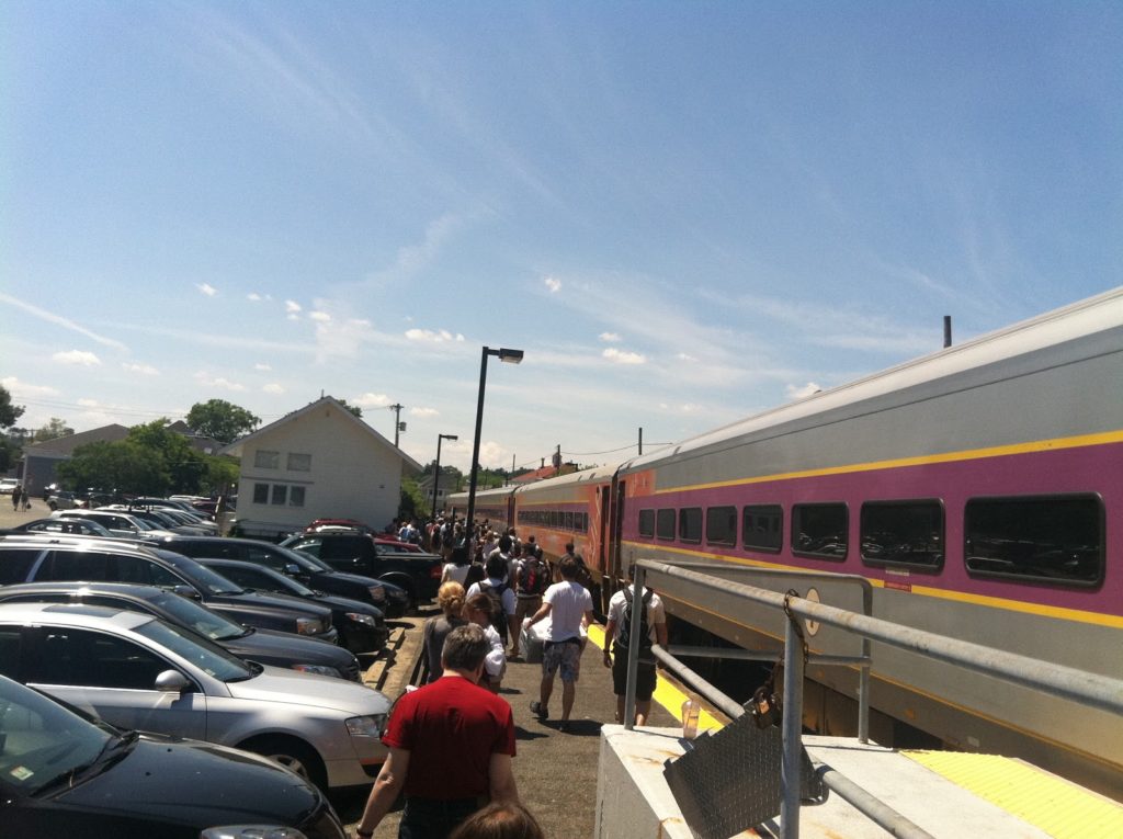
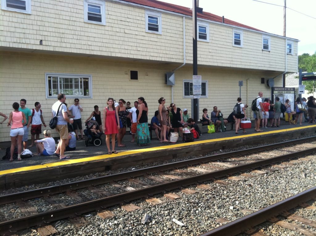
It’s almost impossible to drive to Manchester-by-the-sea’s Singing Beach, which has restricted parking (town residents only), but it may be the most accessible beach on the north shore as it is just half a mile’s walk from the train station. (There is additional parking for “outsiders” for $25—at the train station.) Several beaches in Gloucester and Rockport are about a mile from stations further out on the line. And Plum Island is a long walk from Newburyport but a manageable bike ride. For the beach, the train is relatively popular; a six-car consist today was about 80% full today from North Station until the train emptied out at Manchester for the walk to the beach. (And on the way home, the platform was crowded several deep and the conductors opened all cars to accommodate the crowd.) Service was punctual, and as fast as driving. With gas near $4 per gallon, it was cheaper, too.

A full train disembarks at Manchester-by-the-sea.

Obviously the train service is working, but the T doesn’t seem to realize that they have a product to market. Weekend service on the commuter lines has waxed and waned over the years, but is now provided almost universally. Headways are genearlly two hours with service in to the evening. Loads carried are light, but full, locomotive-hauled trains are operated. Except for special events (baseball games, major downtown events like the every-few-years arrival of Tall Ships) service is usually limited to one or two cars in a full-train consist. Since the trains are running anyway, any new person on the train is revenue with a marginal cost of nearly zero. So the T should promote the use of these trains whenever they can.

And sometimes they do. In the winter, Wachusett Mountain ski area has partnered with the T to promote the “Ski Train” to Fitchburg, with a shuttle service to the base of the mountain. And the T turned one of their train cars in to a “bike car” which is half seats and half bikes (similar to cars in regular service on Caltrain) which are used, weekends, only, on alternating trains to Rockport and Newburyport (all non-rush hour trains accommodate bicycles, however). They promote this car as a way to reach even more beaches (the south side has a similar car on the Greenbush line), but there’s little information on, say, exactly which stop you should go to get to which beach. Or a full schedule of non-bike car trains which go near the beaches. So if you want to go to the beach on the T, you have to plan it yourself.

Beach-goers line the platform awaiting a train back to the city.

Many people certainly do just that. But the MBTA should put a line item in its publicity budget to promote weekend commuter services to the ocean. With a ridership of 1.3 million daily, there is probably a large contingent that don’t know that it’s possible to spend the day at the beach without a knuckle-dragging slog through traffic or exorbitant parking fee. Ads on subways and buses with brochures or—these days—QR codes could steer people to information, and the agency could develop a website with various transit-accessible options (say, a commuter rail map with the distance from each station to nearby beaches).

Most weekend services surely run at a loss—operating a six-car train with 60 passengers is not particularly cost-effective. But every bottom you put in a seat is revenue for the MBTA—and quite possibly cars off the road. The T should do more to tell people the destinations it serves outside of home and work.

Charlie and the Clipper

On a recent trip to San Francisco, I found out that they were still giving away their new, integrated, cross-agency (and boy, with Muni, BART, Samtrans, Golden Gate, Caltrain and AC Transit in the city alone there are a lot of agencies to cross) smart card, called the Clipper Card. I stuck one in my pocket and tapped on to a ferry, a bus, a train, a subway, and a streetcar. Except, it wasn’t quite the tap-your-wallet convenience I’ve come to associate with my Charlie Card.

So I experimented. Clipper and LA TAP card worked fine. Clipper and Charlie? Not so much. And a week later in Boston, well, the Charlie Card didn’t work well here unless the Clipper was out of proximity. It’s too bad; proximity cards are very convenient, speed transactions and boarding, and can make a multi-agency hodgepodge like San Francisco (to say nothing of LA) somewhat more seamless. But, really, someone should assure that the cards’ frequencies don’t interfere with eachother.

(Or, perhaps, I can dream of a day when transit agencies nationwide are all on the same frequency, and system. Ha!)

(posted from iPhone; will clean up later)

Ugh … the Silver Line

Originally posted as a comment on The Transport Politic. I’m sure I’ll write about the Silver Line again.

The Silver Line has so many problems.

First off, there’s this bizarre notion that people from Roxbury and Mattapan need to get to the airport. All the time, forever. It’s probably not the case. I’m not one to make brash generalizations, but here’s one: the people who generally use the airport are folks from affluent and/or student-infested parts of Boston. At higher rates, anyway, than the Roxbury-Mattapan. For this community, access to downtown Boston and better-than-bus service is probably paramount. It would make much more sense to take this $114m and build a spur of the blue line in to the actual airport. Build a loop to the terminals. Heck, build it in to Central Parking, where there are elevated walkways to all the terminals. Eliminate the shuttle bus (which I once tried to take before a long weekend and it was packed to the gills with college students with dozens more waiting to board).


View Logan Blue Line Spur in a larger map

Second, the Silver Line from South Station to the airport is very slow. The tunnel is fast enough—the speed is slow but it’s grade separated, so it works. The problems arise once the buses reach the surface. The then cross D Street and proceed to drop the trolley poles and switch to petroleum. The route then takes a convoluted backtrack loop back towards South Station, across D Street, through several lights, before the bus can finally turn down in to the tunnel. $15b and they couldn’t build a ramp straight to the airport, which would have been rapid.

Then, the airport. Since Boston is the furthest northeast city in the country, Logan has never developed in to a hub airport. Thus, no one has ever built one big terminal. So the airport is a hodgepodge of terminals, each with an access road which gets choked with traffic. Sure, the buses can sometimes bypass these queues, but they still have to go through the loops in to terminals A, B, C, and E (with two stops in B—Terminal D doesn’t really exist). Ten of fifteen minutes later, they loop back in to the tunnel and a mess of roads before looping back to South Station.

I’m very glad that “Phase III” has been all but nixed by the Feds. A $1.4b tunnel would not fix the main issue that trips are scheduled to take 38 minutes to go from South Station to the airport and back. As the crow flies, this is just over a mile. A Blue Line spur to the airport, with stops at Maverick and Aquarium, would tie in to the rest of the system with trip times of maybe eight minutes, tops, with faster loading and more capacity, to boot.

*****

But that’s really actually not the worst part. Again, I’ll start by explaining that I am happy that the $1.4b tunnel from pretty much nowhere to pretty much nowhere with a couple sharp curves thrown in was not funded. From Boylston Station on the Green Line five blocks south is a disused tunnel for streetcars, and the plan was to basically decimate that tunnel to build it to bus loading gauge. Here’s the thing—the tunnel ties in to the Green Line—to a four track alignment to Park Street Station—and is grade separated, underground!, at the junction. Basically, if you turn back one line of the green line at Park Street, you could add in another without increasing capacity on the congested central subway.

And this tunnel would tie in splendidly with light rail down towards Mattipan. You build a new portal at Tremont and Oak and cut diagonally across the Turnpike and NEC from Shawmut to Washington. Washington Street is wide enough for trolley cars to not interfere with parked cars by occupying the center lanes. (Washington Street once had the elevated above it.) Stations in the center of the tracks, proof of payment ticketing perhaps, and you don’t impede traffic significantly, which could pass stopped trains.

Getting through Roxbury might be fun—but you could use the old elevated right-of-way for one or both tracks of a light rail line. Or tunnel underneath if you had the dollars. From there, Warren Street has two lanes each way plus a wide median, so congestion wouldn’t be a major issue) to Quincy Street, where you’d then have to build on a two-lanes-plus parking street to Blue Hill Avenue for less than half a mile. Cut parking to one side of the street and build wide lanes and you’d be fine.

Then you hit Blue Hill Avenue. The Avenue is three lanes each way plus a wide median all the way down to Mattapan, where you could connect with the High Speed Line. Trolley tracks could be in a separate median (like Comm Av or Beacon Street in Brighton and Brookline). In fact, this was the case in the past.


View Boylston-Roxbury-Mattapan in a larger map

For a heck of a lot less than 1.4b. (Portland can build a streetcar for $25m/mile. This is 7.5 miles. Make that $30, throw in $50 for a new portal at Tremont and $25m for a bridge across the Pike, and the cost is $300m.