The new Harvard Bridge bike lane, animated-GIF style

The state, thanks in part to LivableStreets’ tireless advocacy, finally repaved the Harvard (/Mass Ave/Smoot) Bridge, and restriped the bike lane to a full five foot width. Previously it had narrowed to 20 inches at the foot of the bridge, which was substandard and dangerous. Now, it’s 5 feet wide, making it much easier to navigate on bicycle, and keeping the cars in the middle of the road. Here, in two pictures is the progress that was made:

In the animated GIF (on the right; give it five seconds), I didn’t perfectly take the picture from the same angle, so it’s not layered right on top (the “before” picture was taken the summer doing recon from a BS traffic stop). Note the location of the drain, and that while the bike in the “before” is closer to the drain, he’s outside the bike lane, while in the “after” the cyclist is further from the drain, but comfortably in the bike lane. Yes, at the edge of the frame is a Street Ambassador, the work of whom led to this better bridge. So that’s cool, too.

Also, the pictures were taken at 1:30 (standard time, November) for the after and 6:30 (daylight time, July) for the before, and the shadows are the same length.

The weather is cooler. The Longfellow is the same.

Twice this summer, we counted vehicles on the Longfellow. Between June and July, when the lanes of the bridge were shifted and constricted, bicycle traffic was level (well, actually, it rose slightly) while vehicular traffic decreased. I was otherwise occupied this September and didn’t get a chance to do a comparable bike count until last week, when I eked out an hour to sit on the bridge.

And the results are so mundane they aren’t even worthy of charts and graphics. Basically, the numbers were within a thin margin of error of those from July:

(All values for peak-hour of the count, note that the Longfellow runs east-west; Eastbound towards Boston, Westbound towards Cambridge)

Eastbound Bikes: 308 (July: 298)
Westbound Bikes: 63 (July: 68)
Eastbound Pedestrians: 65 (July: 83)
Westbound Pedestrians: 191 (July: 201)
Inbound Vehicles: 411 (July: 415)

So the bridge, even after two months of people getting used to the traffic patterns, has seen no major changes. Any drop in non-motorized use might be attributable to cooler weather (in the mid 50s rather than the upper 60s) or to random variance. And assuming a normal traffic day, there has been no significant increase in traffic since the bridge has opened.

It’s the last piece that I find most interesting. It really speaks to the concept of “induced demand.” With the wider Longfellow, we say 800 vehicles per hour traversing the bridge in June. Once the bridge was narrowed, that number fell to 400. There were weeks with dozens police directing traffic, but the number of cars very quickly hit a new equilibrium. People do not seem to need a major education campaign to figure out where to go. If the new roads are gridlocked, they’ll find alternate routes. The system has not ground to a halt (although inbound at the evening rush often backs up the length of the bridge). There are too many variables to find out if people have switched to other routes or modes or just not made the trip, but traffic in the morning across the Longfellow has not been the apocalypse.

The next step on the BU Bridge area for bikes

The City of Boston recently made somewhat dramatic improvements to the bicycle facilities along Commonwealth Avenue. The formerly orphaned bike lane has been restriped through the intersection, and the new paint is all bright green. In addition, there are reflectors in the road to the right of the lane which I can attest are very visible from a vehicle at night. It’s a good start.

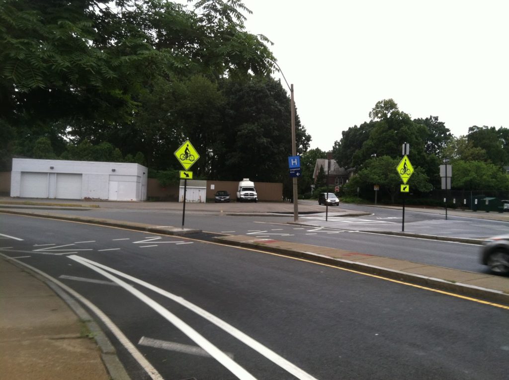
Meanwhile, Brookline has installed contraflow bike lanes on Essex Street to allow cyclists to go from Essex to Ivy to Carlton and allow a low-traffic alternative to get from the BU Bridge to the Longwood area. (And for those of us headed to Coolidge Corner, another block before we take a right.) Going towards the bridge, the town has striped in a bike lane. And, more importantly, they’ve cut a “bicycle crosswalk” across the BU Bridge loop (Mountfort Street) to allow cyclists to get from the Brookline streets to the BU Bridge without having to cross medians, loop around through the intersection of death, or ride the sidewalk to the light. It also allows cyclists coming from Brookline to skip Commonwealth altogether, a great boon to cyclists who don’t want to ride one of Boston’s widest and busiest streets. So, what was once a death trap for cyclists—and is still rather cumbersome—is getting better. (The picture at right shows the bike lane in the foreground and the crossover in the background.) There is some background information in this document.

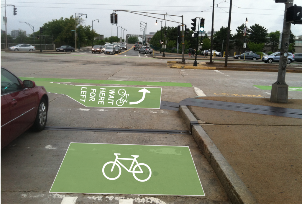
The next step, I think, is to better allow cyclists coming from the west on Commonwealth and headed towards Cambridge, would be a two-stage bike turn box. This is not a new concept—it even exists in Boston—and goes as follows:

  1. An eastbound cyclist on Commonwealth approaches the BU Bridge.
  2. The cyclists, upon a green light, goes through the light, then pulls in to a separate line to the right of the bike lane and turns their bike towards the bridge.
  3. Once the light changes, the cyclist pedals straight across and in to the bike lane on the bridge.
Here’s a picture of the current facility, with an idea of a two-stage bike box sketched in, as well as a bike box for cyclists coming from Mountfort:
I would hope this is on Boston Bikes’s radar screen (if it’s under their jurisdiction and not the state). It would be a great help to more novice cyclists who may not know it’s an option. The rest of us already do it.

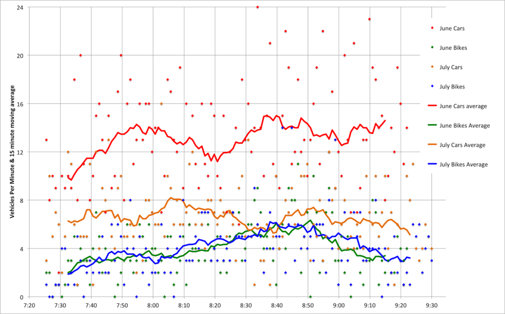
One chart shows the change in Longfellow traffic

Boston’s massive reconstruction of the Longfellow Bridge
began this month. Over the next three years, traffic will be severely
restricted, bicyclists mostly accommodated, and rail traffic mostly maintained
across a major link in the transportation system which carries 100,000 transit
riders as well as several thousand bicyclists and pedestrians across the
Charles River (and some vehicular traffic, too).

In late June, I took a baseline, pre-construction count of
morning, inbound traffic across the bridge. With the new traffic configuration
in place (an inbound bike lane, a travel lane, a pylon-lined buffer and an
outbound bike lane, plus the sidewalk) I decided to take a new snapshot of the
bridge traffic. Had traffic declined with fewer lanes available? Are cyclists
shying away from the new configuration?
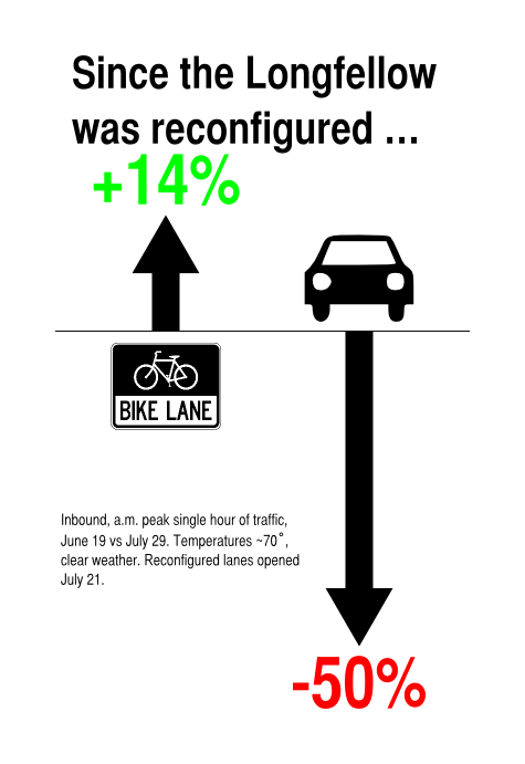
Here’s what I found, summed up in one chart:
Bicycle counts stayed about the same (they actually rose,
overall, and the peak hour saw 308 cyclists, an increase 14%). Vehicle counts, however, showed a dramatic drop, declining by 50% from 840 to 400 during the peak hour of use! It’s interesting that this is
not due, necessarily, to restricted capacity (the one lane of traffic didn’t
back up beyond the midpoint of the bridge at any time when I was counting,
although the afternoon is a different story) but perhaps the perception of
traffic, and the fact that the single lane reduces traffic speed quite a bit.
No lack of praise should be given to MassDOT for this
iteration of the Longfellow traffic pattern. The bicycle facilities are, if
anything, improved over the bridge before, especially considering the much lower vehicular traffic speeds and
volume. And there is no lack of cyclists—even on one of the quietest weeks for
traffic midsummer, there were more bikes than a day with similar weather in
June.
A few other tidbits:
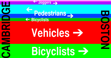
  • Bicyclists and Pedestrians accounted for 60% of the traffic on the bridge. Cars transported fewer people than human power. (See diagram below.)
  • Between 8:30 and 8:45, there were actually more bicyclists
    crossing the bridge than vehicles.
  • Pedestrians of all types outnumber cyclists (although this
    includes both joggers and “commuters”—as defined by me—in both directions).
  • The flow of “commuting” pedestrians is a mirror image of
    bicyclists. There are four times as many Boston-bound cyclists as
    Cambridge-bound, but more than twice as many Cambridge-bound Pedestrians as
    Boston-bound. (There are fewer joggers, but they exhibit a preference towards
    running eastbound across the bridge, differing from the other foot traffic.) Overall there are more bicyclists going towards Boston and more pedestrians towards Cambridge.
  • While 24 Hubway shared bikes accounted for only 5% of
    inbound bicycle trips, the 20 outbound Hubways made up 18% of the
    Cambridge-bound bicyclists.
  • Only four cyclists used the sidewalk, and only one rode the wrong way in the contraflow lane. (I yelled at him.)
And one more diagram showing bridge use (for the record, one chart, one diagram and one infographic, and one annoying and slightly misleading title):