MassDOT’s reasoning for closing Riverbend Park is a farce

If you’re going to close a park for a highway project, you better have a damn good reason for it. MassDOT’s reasoning for closing Riverbend Park this summer in Cambridge doesn’t even come close.

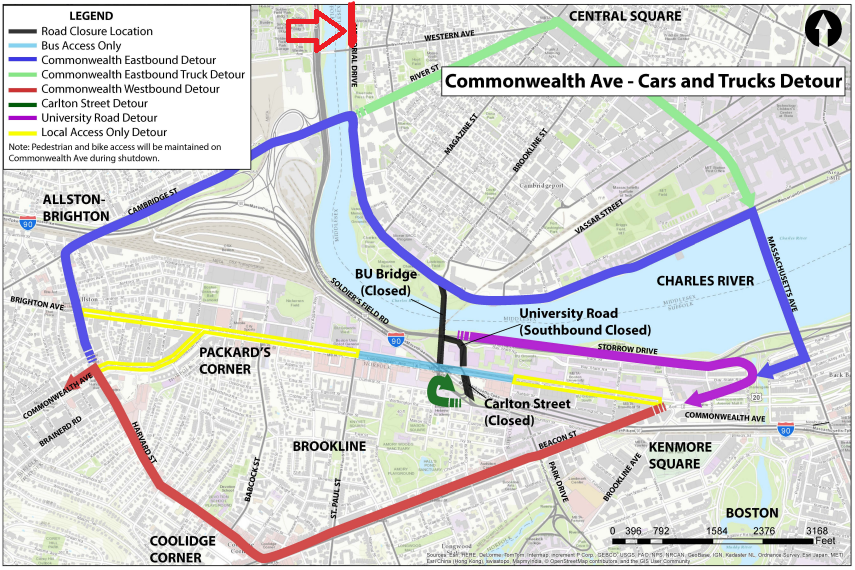
Here is a letter John Hawkinson obtained which MassDOT sent to the DCR asking them to keep Memorial Drive open in Cambridge for two Sundays. This letter was never made public, and at no time has MassDOT’s public traffic management plans stated that Riverbend Park would be closed. The letter does not clearly cite a threat to public safety as would be required by state law. In addition, it does not even mention any mitigation for the temporary removal of parkland to satisfy federal 4(f) regulations. None of this has been this mentioned in any MassDOT traffic management plan: the idea was to keep it quiet until the last minute.

This is unacceptable.

The letter does not remove any doubt that there was no thought given to this by MassDOT, just a reaction that more roads are always the solution. This is wrong. The third paragraph of the letter gives the rationale for requesting the removal of this park. The reasons given are:

“The approved traffic management plan requires the use of Memorial Drive as a detour route for both automobiles and MBTA buses throughout the duration of the shutdown.”

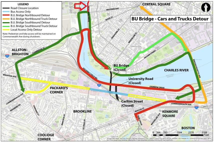
However, none of the portion of Memorial Drive used for the detour is affected by the Riverbend Park closures on Sunday. I’ve taken the liberty of adding big red arrows showing the southern extent of the Riverbend Park closure overlaid on MassDOT’s traffic management plan:

Anyone see the problem here? I sure don’t. It seems that all of the detours take place away from the area which is closed on Sundays. The only portion possibly affected would be one half of the BU Bridge southbound detour, except that is adjacent to the portion of Memorial Drive closed. The Riverbend Park closure would actually improve conditions for this portion of the detour, since cars making a left from Memorial Drive to Western Avenue would have the entire green cycle to make the turn, from both lanes, since there would be no oncoming traffic.

Yet there have been no traffic studies or traffic counts.

The “rationale” continues:

“It is important that Memorial Drive remains open to all vehicular traffic during the above requested dates to ensure the smooth, orderly and safe routing of traffic around the limits of the project.”

It is true that we need to have safe, orderly traffic! But Riverbend Park does not affect the portions of Memorial Drive affected by any traffic detour. In fact, by closing Memorial Drive, some drivers may choose to avoid the area altogether, reducing traffic in the project area and reducing congestion.

There is simply no explanation for MassDOT requesting that DCR keep Memorial Drive open, and Riverbend Park closed, during the Commonwealth Avenue Bridge project. With more construction upcoming in the area, we need to make sure that MassDOT has a very high standard for any adverse impacts to parkland. In this case, they have failed to meet such a standard.

Call your Representatives, call your Senators, and demand that Riverbend Park remain OPEN.

Update: I received a response to a call placed to MassDOT. The general process, which apparently happened behind closed doors, was as follows: someone from the “public safety” community asked that the road remain open. MassDOT, without any data or modeling (I asked if any existed and was told that it did not), decided that it was, in fact, a public safety issue, and requested that the DCR keep the roadway open. There was no public process, and the letter only cites the “smooth, orderly and safe routing of traffic,” saying nothing about emergency vehicles.

It turns out, reading the letter closely, MassDOT doesn’t even know where the park is. They request a suspension of “the ban of the use of motor vehicles on Memorial Drive between Western Avenue and Mount Auburn Street.” Yet Riverbend Park extends between Western Avenue and Gerry’s Landing Road; it runs parallel to but never intersects Mount Auburn Street. This is a small oversight, but shows how little mind was actually paid to this issue.

The staffer I spoke with mentioned that it would impact emergency vehicle access to Mount Auburn Hospital (which is not accessed from Memorial Drive) and to the LMA. If there were traffic, then emergency vehicles could use Memorial Drive by moving barricades (this could be staffed by state police traffic details) and then use the BU Bridge, which will be open to buses and emergency vehicles. But that wasn’t brought forth as an option, there was no process involved, and instead the “close the park” was put forward as a solution, one still looking for a problem.

How MassDOT stacks the deck: Red-Blue edition

The Red-Blue connector is probably the biggest bang-for-your-buck piece of rail infrastructure in the Commonwealth of Massachusetts. With 1300 feet (¼ of a mile) of new subway, it would both provide a much better connection between East Boston, the airport and and the Red Line and serve as a major core capacity project. From the south, the Red Line, at rush hour, operates at peak capacity through downtown to Charles; as it drops passengers at South Station, Downtown Crossing and Park, it takes on transferring passengers and the load stays high. At Charles, however, there are many more destinations than origins, and demand drops. Right now, all Blue Line passengers destined for Kendall or beyond are forced on to the Green or Orange line and the Red Line at this high-utilization point. The Red-Blue connector would allow them to bypass this downtown congestion, reducing the strain on the near- or at-capacity central portion of the subway network. (Oh, and it would also allow a rethinking of Cambridge Street, which is incredibly dangerous for anyone not driving a car. But it has a pretty median.)

This page, in the past, has suggested that it may be cheaper to build an elevated Red-Blue connector, and also cast doubt (twice!) on the MassDOT’s cost estimates. Their claim is that it would cost $750 million to make the extension; which is a cost per mile of $3 billion. This per-mile cost is double the cost of recent tunnel projects in Seattle and San Francisco (where, as you may be aware, they have earthquakes) and even more than the Second Avenue Subway in New York. It’s a completely outlandish number.

And this is entirely by design.

The state is required to plan the Red-Blue connector, but they’re not actually required to build it. Because MassDOT is, at some levels, a morass of incompetence (see Extension, Green Line), they operate under the assumption that nothing new should ever be built, even if there are dramatic improvements to the overall transportation network. Remember, these are the same people who look at ridership growth and declare it “basically flat.” But not only do they want to do as little as possible, they actively stack the deck against their designs to come in so costly that they don’t make sense to build. This is the idea: inflate the cost so much that it would not make any sense to build. It’s deceitful. It’s duplicitous. And at MassDOT, it’s standard operating procedure.

(On the other hand, when MassDOT—or MassHighway—wants to build something, like the outlandish mutil-tunneling of rail lines in Dorchester to add highway capacity to the Southeast Expressway, they don’t bother to put forth a cost estimate. Or remember when we didn’t add a lane to 128 because it was going to cost too much? Yeah, me neither.)

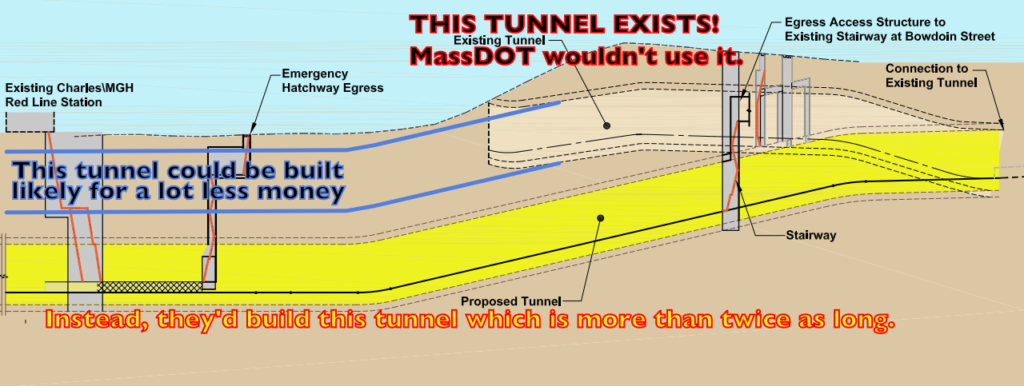
Here’s how it’s done. As we discussed, there is an existing tunnel to Joy Street which was used until the 1950s to move East Boston cars to the old Bennett Street Yards in Harvard Square for heavy maintenance. The obvious solution is to use as much of this tunnel as possible—both to minimize digging in the street and to minimize disruption to current service—yet the state’s two alternatives don’t use it at all. Instead, with minimal justification, they propose a half-mile-long deep bore tunnel 50 feet below grade, tying in with the existing tunnel just west of Government Center. Using tunnel boring machines (TBM) makes sense for tunnels of any length, as the impact to the surface is significantly less. It is also, for longer tunnels, significantly cheaper than cut-and-cover methods. It’s fine to have that as one alternative—there are certainly advantages to using a TBM—but the fact that the alternative analysis only mentions TBMs makes it, well, not really an alternatives analysis at all.

The benefits of a TBM, however, only accrue for longer tunnels. The marginal cost of an extra foot of TBM tunnel is relatively low, but the initial cost is very high. A cut-and-cover tunnel here would require 1300 feet surface impact. Using a TBM would require less, but only slightly. Why? Because you still have to dig launch and recovery boxes for the TBM, and where the tunnel needs to be wider for stations or crossovers, it has to be dug out. Considering the substrate in Boston (mud and clay) a TBM would have to build concrete rings as it digs, and any stations or crossovers between the tunnels would have to be dug out separately. And while the total disruption would be somewhat less than a cut-and-cover tunnel, the disruption would be more spread out and extend much further, from Charles Circle to or beyond Government Center, rather than from Charles to Joy Street. Utilities would be affected in either scheme, and it’s possible that fewer utilities would be affected by a more-contained scheme between Charles Circle and Joy Street.

So in addition to carving up nearly as much street space, and over a longer distance, you’d also incur the cost of using a tunnel boring machine (they’re not cheap). You’d be building nearly a mile of new tunnel, while only incurring the benefit of about a quarter of that. And the costs are therefore much higher. This only makes sense if you don’t actually want to ever build anything. [Update 11/2017: I’ve heard through the grapevine that part of the reason only TBMs were analyzed is that Mayor Menino didn’t want anyone digging up the new streetscape on Charles Street, which he liked. The trees are nice for people driving cars, I guess. 10 years later, the road is a potholed mess, so dig, baby, dig.]

MassDOT’s plan would also build tail tracks under Charles Circle beyond the station. Tail tracks are important: it allows a terminal to continue to operate at full capacity even if a train is incapacitated: it can be shoved in to the tail track and out of the way until the end of service (or until service levels are decreased). However, they take up a good deal of space. This is less of an issue if there is extra space (like there is at Forest Hills, Wonderland or Oak Grove) or at Alewife, where the line was originally built to extend to Arlington (the tail tracks actually do cross the border). But in downtown Boston, the tail tracks require significant extra tunneling under Charles Circle, which is expensive and disruptive.

A different, more outside-the-box option is to create a “pocket track” before the final station. This serves the same purpose as the tail track—train storage near the end of the line—but rather than two long tails, it is in the middle of the two tracks short of the station. All this requires is that the tunnel be built wider here (the same width as the platform to the west requires) for this staging track. Additionally, by utilizing the existing layout at Bowdoin (with, perhaps, some modification for longer trains inbound, or even converting the station to outbound service only), the line would retain the utility of the loop there, which is eliminated in both of the state’s alternatives. While this does result in slower operation in and out of the station, it allows redundancy for turning trains: if there is any congestion or another issue at Bowdoin, some or all trains can be turned temporarily at Government Center to maintain service on the rest of the line. Eliminating this loop eliminates any such redundancy. A pocket track and the retention of the loop are nearly impossible with a bored tunnel but with cut-and-cover simply requires a somewhat wider dig.

By requiring long-term construction closure of the line west of Government Center, the state’s plan would also require new construction of a terminal station there. Government Center does have a crossover to its east, but it is a single crossover, which would not be able to handle the rush hour Blue Line schedule. This would require a new double crossover to be installed in what is a narrow section of tunnel. Utilizing the existing tunnel past Bowdoin would preclude this extra cost, as trains could continue to loop there during construction. There would be no disruption when the extension opened—not even a weekend shutdown to tie in new tracks. The same can’t be said for the State’s scheme.

State’s plan in red, my plan in blue.

Here’s a quick rundown on the major elements required to build the state’s version of the Red-Blue Connector:

  • A launch box for the TBM
  • Cut-and-cover tail tracks west of Charles Station
  • Main access to the Charles Station (planned 50′ below grade)
  • Charles Station, proposed as a sequentially excavated cavern but with no explanation of how that will be done in the fill-and-clay substrate in the area.
  • Emergency egress from Charles Station
  • Crossovers east of Charles Station
  • New Bowdoin Station (alternative 2 only)
  • Modification of existing Bowdoin Station and trackage to serve as ventillation (alternative 1 only)
  • Receiving shaft for Bowdoin station
  • Cut-and-cover track for connection to existing track at Government Center
  • New crossover west of Government Center to allow it to serve as a terminal station
  • Total cut-and-cover of approximately 800 feet, assuming the Charles Station can be built below grade (I’m skeptical).
And here’s a rundown of the elements required for a cut-and-cover tunnel from Joy Street to Charles Circle:
  • Main access to Charles Station (20′ below grade)
  • Charles Station cut-and-cover
  • Secondary access to Charles Station (possible because it would require only 20′ of vertical circulation, rather than 50′)
  • Cut-and-cover crossovers and pocket track
  • Cut-and-cover connection to existing tail tracks at Joy Street

Here’s my total-guess cost estimate for the cut-and-cover costs (and I think many of these are quite high):

1. Utility Relocation: 0.25 miles at $100m/mi = $25m
2. Cut-and-cover tunnel (mostly 40′ wide): 0.25 mi at $600m/mi = $150m
3. Rail systems: 0.25 mi at $100m/mi = $25m
4. Egress, NFPA130, etc: 0.25 mi at $200m/mi = $50m
5. Station, 1 at $50m = $50m
6. Street rebuilding, 0.33 mi at $75m/mi = $25m

This totals to $375 million, or half of what the state’s plan would cost. There’s no way to know much the state thinks it would cost, because they didn’t bother to analyze this alternative as part of their alternatives analysis.

Now, the state did address the difference in cost between a bored tunnel and a cut-and-cover tunnel. Well, sort of. The draft environmental impact report has the clause:

The resulting total cost (direct plus offsets) to construct a cut-and -cover tunnel shell is about 1.2 times the cost of the mined tunnel method. This differential may slightly decrease when the balance of construction scope (e.g., station components common to both Build Alternatives) is considered. Based on this relative cost differential and the associated environmental and social impacts, schemes utilizing mining methods were selected for further development and evaluation. 

Uh, this isn’t really how an alternatives analysis works. In a complex construction project, 20% is basically a margin of error. As we’ve seen in some other deep boring construction, it’s not uncommon to have an unforeseen obstruction which can dramatically increase the cost of a project. This can also be an issue with a cut-and-cover tunnel, although Cambridge Street was widened in the 1920s so the utilities there are a bit less complex than the centuries-old sewers under many Boston streets. The point of an alternatives analysis is too look at different alternatives and see which is the most appropriate. In this case, there are not enough alternatives, and very little actual analysis. I wouldn’t be surprised if a full analysis showed that 1300 feet of a cut-and-cover tunnel was a good deal less expensive than twice as much deep bore tunnel and the additional track connections involved.

And there is no information in this report about how they are going to build the Charles Blue Line Station 50 feet underground in the substrate of Boston with sequential mining. The Second Avenue Subway is being built in hard Manhattan schist which can be blasted apart while still maintaining structural integrity above. I’m not an engineer with this sort of experience, but given that there is no explanation of how it would take place, I’d have to doubt its veracity. The current idea is explained that the tunnels would be bored and then the station areas would be mined out in between the bored tunnels, using their structure to support the road above. I guess that could work. But it seems to add several steps (and thus increase the cost) by building the tunnels only to hack them apart to build space for stations and crossovers in between. When asked in 2011 if it was inflating the costs of the project, MassDOT was very defensive in claiming that they weren’t, and that Very Important People said the same thing, yet they didn’t actually explain why they chose the scheme that they did (beyond “we hired someone”) and as I outline here, it seems they put their thumb on the scale.

Even giving them the benefit of the doubt that a bored tunnel is the best option, the cost estimates seem out of hand. The cost of the 72nd Street Station cavern—which is 1300 feet long, the length of the Red-Blue connector from Charles to Joy Street—plus the track connections to 63rd Street is $431 million, significantly less than the Red-Blue connector. This, for a project taking place 100 feet below the street in New York City, which may be the most expensive construction market in the world.

To put it another way, I find it very hard to fathom that a ¼ mile cut-and-cover tunnel with a single station (for which the headhouse is already built) connecting in to an existing tunnel would cost three quarters of a billion dollars. Or $3 billion per mile. Some more comparisons? The cost of the Longfellow Bridge—twice as long, and rebuilding a century-old bridge while maintaining transit service—is one third the projected cost of Red-Blue. That can’t be right. The Big Dig cost less than $3 billion per mile, to build highway tunnels three times as wide, over and under several active railroad tunnels, with more ventilation and dozens of ramps. And the Red-Blue connector would cost as much? Please.

A layman’s staging plan for Red-Blue. Simplified, a bit.

A layman’s plan (as follows) would involve a shallow cut-and-cover tunnel, likely using slurry walls to support the excavation. (See Dig, Big). The tunnel would be 40 feet wide at the Charles Station and to the east for the crossovers and the pocket track, where it would taper to 20 feet for the connection to the existing trackage at Joy Street. The Cambridge Street roadway is at least 64′ wide between Charles Circle and Joy Street; with parking it is 80 feet wide. Assuming the construction could be completed in two phases (two 20-foot-wide excavations) with a 5 foot buffer around each, this would leave 34 feet for road for traffic during any construction, enough for two lanes of travel in each direction (or two in one direction, one in the other and an emergency vehicle access lane). Cambridge Street is currently a horror show for cyclists and not much better for pedestrians, and the project would allow a complete street to be built in its stead.

See larger-size file here

Would there be traffic headaches during construction? Sure, just as there have been with the Longfellow Bridge adjacent to the project area. Would it be apocalyptic? Much like the Longfellow, it would not. And the effects would stretch only from Charles Circle to Joy Street, rather than the state’s plan, which would have impacts extending from west of Charles Circle to Government Center, at least. In any case, either scheme will have short term traffic issues, but a long-term benefit, both with fewer vehicles and the potential to build a “complete street” with separated bicycling facilities and better pedestrian facilities. And get rid of the damn median!

There is no logical reason that the Red-Blue connector should be, per mile, the most expensive subway construction in the country. Unless it’s by design. And—yes, to point a finger at MassDOT—that’s exactly what I think has happened.

tl;dr: this is why we can’t have nice things.

Remember: changing road pricing can have unintended consequences

A few years ago, I wrote about how the 1996 changing of the toll structure of the Turnpike in Newton dramatically affected traffic. In that case, changing the toll by $1 created a new calculus where many commuters took an alternate route to avoid the toll, leading to traffic on side roads. The state will soon change the toll structure on the Tobin Bridge, going from $2.50 in one direction to $1.25 in each way. They claim it will be revenue neutral (it will likely be somewhat revenue positive, actually; see below), but there is not talk of the traffic impact, because the amount you’re charging is the same, so it won’t change the traffic, right?

Wrong. There may be a major traffic impact.

First, the revenue projections. It is very likely that revenue will actually go up. Today, it costs $2.50 to go south on the Tobin, and it is free going north. For a motorist coming south on 95 in Peabody, it is usually only 2 to 3 minutes longer to loop around on 128 and 93 versus the trip straight down Route 1. (At rush hour, it depends more on traffic, but the majority of travel on the Tobin Bridge is at non-rush times.) The 128-93 route is about five miles further, but even assuming 50¢ for gas (most motorists don’t figure in the full marginal cost of a mile traveled, many probably discount the extra gas anyway) it is still a saving of $2 for three minutes of time, a rate of $40 per hour. That’s generally worth it.

Which is much of the reason why, in 2015, there were 51,000 northbound vehicles daily on the Tobin, but just 34,000 going southbound. (Some of this may be explained by things like the location of on- and off-ramps and traffic patterns, but most of it is likely due to the toll.)

Equalizing the toll will change this calculus dramatically. Many motorists who had balked at the $2.50 toll may be more willing to part with $1.25 to save a couple of minutes. And while some will avoid the bridge northbound, it will be far fewer than if the toll were flipped and it was charged full rate northbound, and free coming south. Guessing wildly, I’d guess that 5,000 motorists will use the bridge coming south, and 5,000 will abandon it going north. This means a lot of new toll revenue for the state.

Currently, the state collects $2.50 from each of the vehicles using the bridge southbound (we’ll assume that the higher rate for larger vehicles offsets the discounted toll charged to Charlestown and Chelsea residents). With 34,215 vehicles counted per weekday in 2015, this amounts to $85,537.50 in toll revenue. My wild-guess assumption is that there will be 5,000 more southbound travelers (39,215) and 5,000 fewer northbound travelers (46,108), each paying $1.25, for a total of $106,653.75, or an additional $20,000 in toll revenue daily. Even discounting lower traffic on weekends and holidays, this will probably add in the neighborhood of five to six million additional dollars of toll revenue for the state.

The tolls will be fairer and make more sense and raises more money for the state, which can always use more money for infrastructure. This is a win-win …

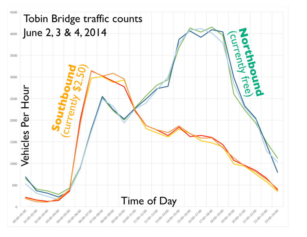
… unless it has an unforeseen impact traffic. The bridge itself is nowhere near congested, especially coming southbound, where peak-hour traffic counts average just 3000 per hour (1000 per lane per hour), well below the 1500 where congestion begins in earnest (in the chart above, you can see how the northbound traffic levels off at about 4000 per hour, even dipping slightly during the 4 to 5 p.m. peak, which may be due to heavy traffic on roadways accessing the bridge reducing throughput). The issue with more inbound traffic is at the end of the bridge.

Most of the traffic (about 85%) stays on the loop ramp to the Leverett Connector and O’Neill Tunnel. An additional stream of traffic is added from Rutherford Avenue, and there is considerable merging and sorting of this traffic. With only two lanes, this is much nearer capacity; adding more vehicles may create merge traffic which will cause significant backups. The traffic on the Leverett Connector and the tunnel should be a zero-sum game, shifting users from I-93 to Route 1, much like the Turnpike toll removal didn’t necessarily increase traffic, but changed where it got on and off of the highway. Even minor changes can have consequences. This one may work fine. Or it may not.

Still, I’m for this change, as it is sensible policy (even if it might have some unintended consequences). In fact, the Commonwealth should explore avenues to toll all the highways leading in to Boston at a rate equal to the Turnpike. Tolls on the Turnpike are not a detriment to the local economy, which seems fine to be churning alone just fine. And other than federal policy (which may be changing), there is no logical reason why Turnpike commuters should have to pay $5 a day to get from 128 to the city while I-93 commuters get in for free. And while the dollars from the Tobin change are relatively small, charging a sort-of congestion charge for other highways leading in to Boston could bring in big dollars. I-93 could be tolled at $2.50 in both directions from 128 to the city, with a lower toll for Route 2 ($1.25), perhaps waived for commuters parking at Alewife. The harbor tunnel tolls, currently $3.50 one way, could be reduced to $1.25 each way to match the other tolls.

At this rate, and assuming that 10% of travelers would carpool, take transit or use side roads to avoid the tolls (although with electronic tolling, it’s harder to simply avoid a toll booth), this would increase the equity of the transportation system, while at the same time raising more than $600 million annually for road maintenance. Considering the age and state of many of the roadways, bridges and tunnels in the Commonwealth, this money could be spent making sure that the roadways are maintained statewide. Unlike a vehicle mile tax, this is not a new concept; it’s one which has been in place on roadways throughout the Commonwealth for nearly a century (far longer if you account for the 19th century incarnations). And unlike a statewide gas tax, this targets users of the state’s most crowded and overtaxed infrastructure, and may be a factor leading drivers to consider other modes, which often run parallel. The Turnpike users already pay tolls. It’s high time others did a well.

Go to a Public Meeting … Tonight!

In the past, this page has implored people to go to public meetings. There’s one tonight that you should definitely put on your calendar:

The City of Boston and MassDOT is rebuilding the North Washington Street / Charlestown Bridge between Boston and Charlestown. It is designed with top-notch cycling and pedestrian facilities, but the designers seem to have forgotten about transit. Five bus lines cross the bridge carrying 20,000 passengers per day, including the 111 to Chelsea—a lifeline for that community—yet these riders are subject to the same delays as traffic.

There is plenty of room as the bridge is design for transit priority as it is designed, and it is most important to have a lane on the inbound side. At rush hours, 30 MBTA buses (as well as many private, last-mile shuttles) carry 1200 passengers across the bridge per hour. At the same time, the two lanes of traffic are used by about 2000 vehicles, or 1000 per lane per hour. So a lane of buses is more efficient at moving people than a lane of car traffic, even if there’s only a bus every 2 minutes.

What’s more, this will dramatically improve operations and reliability. Approximately 5000 people cross the bridge inbound by transit during peak hours inbound, at times when there are often five to ten minute delays. If a bus lane saves an average of five minutes of travel time on weekdays, this will amount to an annual savings of 100,000 hours for passengers on the buses serving this route. For bus operations, a five minute savings amounts to 10% of the route, which would allow 10% more riders to be carried on the same number of buses, increasing the efficiency of the route.

It’s also low-hanging fruit. The entire bridge is being redesigned, so it’s easy to add in a few feet necessary for a bus facility. There are no parking spaces, so there are neither impacts to the neighborhood losing parking nor issues with designing roads to accommodate bus lanes and parking spaces, one of many of the problems the Silver Line has. It should be a slam dunk. If we can’t get transit priority here, how ever are we going to get it elsewhere?

The details:

6:30 PM 

The West End Museum 

150 Staniford Street 

Boston, MA 02114

We need as many people to come and speak out for transit priority as possible! See you there!

Can’t make the meeting? Send public comments by Dec 25 to:

dot.feedback.highway@state.ma.us attn Project File No. 604173

or

Patricia Leavenworth, P.E., Chief Engineer, MassDOT, 10 Park Plaza, Boston, MA 02116, ATTN: Bridge Project Management, Project File No. 604173.

The “Profitable” CapeFlyer: Innovation? Or Accounting?

When a teenager borrows his parent’s car for a cruise around town, he assumes that driving is cheap. He drives 20 miles, put a dollar’s worth of gas in the tank, and voila, it only costs 5¢ per mile. Never mind that mom and dad plunked down $20,000 for the car, paid sales and excise taxes, and take it in for maintenance (and probably pay for the increased insurance cost that come from having an inexperienced driver as well). Those are all fixed costs, whether Junior drives it or not. Junior only pays the marginal cost of driving—a few cents per mile—which is a small percent of the actual cost of owning and operating a car, so to him, it seems pretty cheap.

The Frontier Institute makes exactly this point in a recent blog post (I even get a mention!). Now lets extend this logic to the recent, inaccurate report that the CapeFlyer train makes a “profit”, while weekend Commuter Rail service operates at such a loss that the MBTA Fiscal Control Board wants to cut it. The Control Board unfairly compares the two services, using the same “logic” that makes Junior think that driving is a great bargain.

If someone else pays for every aspect of driving except for the gas, then, yes, driving seems cheap. If someone else pays for the all of the fixed costs of operating a passenger rail service except for the crew and the fuel—as is the case with CapeFlyer—it seems cheap as well. Comparing CapeFlyer’s marginal costs against the overall cost of Commuter Rail is as silly as saying that a teenager’s topping up the tank of their parents’ car pays the entire cost of car ownership.Yet that’s exactly what the MBTA Control Board does in claiming that the “innovative” CapeFlyer is a model for weekend Commuter Rail funding. It’s not.

A bit of background: in 2013 MassDOT and the MBTA started running the long-overdue CapeFlyer service from Boston to Hyannis (in about 2:20, just 35 minutes slower than 1952!). The train makes three round trips per week, one each on Friday, Saturday and Sunday, from Memorial Day to Labor Day. It has decent ridership—nearly 1000 per weekend—which is not bad given its limited schedule. And according to every published report, it turns a profit.

Wait, what? A train turns a profit three years in a row? If it’s that easy to turn a profit, then we should have Commuter Rail popping up all over the place, right? Private companies should be clamoring to run trains every which way. If it is profitable to run a few round trips a week to the Cape (with mostly-empty trains back; I can’t imagine there are a lot of Cape Codders coming back to Boston on a Friday evening), then surely full rush hour trains—some carrying upwards of 1000 passengers—must make a mint for the MBTA.

Of course, the reason the CapeFlyer makes a profit is because its finances are accounted for very differently than the rest of the MBTA: it makes a profit against its marginal operating costs, but this misleading calculation does not account for the significant fixed costs that come from running a railroad. There’s nothing wrong with this – the CapeFlyer runs on the weekend and uses equipment, crews and trackage which would otherwise sit idle. It’s a good idea to offer people more rail options. That’s not the issue.

The issue is that when the MBTA Control Board proposes cutting Commuter Rail weekend service, they compare that service against the CapeFlyer, without accounting for the fixed costs that CapeFlyer doesn’t have to worry about. If we analyze the cost of weekend Commuter Rail service the same way we analyze the cost of CapeFlyer service, the Commuter Rail service would look a whole lot cheaper than the T’s Control Board makes it out to be. But when the preconceived agenda is to cut service, a fair comparison quickly becomes an inconvenient comparison, and therefore they resort to the accounting equivalent of comparing apples with oranges.

Let’s do some math.

The CapeFlyer runs 15 to 16 (16 in 2015) weekends a year, plus extra runs on Memorial Day, July 4 (sometimes) and Labor Day. That’s a total of 47 to 51 days—let’s say 50 for the roundness of the number. The distance from Boston to Hyannis is 79.2 miles (about 80), and it makes a round trip each day, so the total distance traveled is about 8000 miles. The operating costs are about $180,000, yielding an overall operating cost of $22.50 per train mile (or about $750 per train hour; note also that a Northern New England Intercity Rail Initiative report had very similar operating costs for a five-car Commuter Rail consist: $22.97 per train mile or $793 per train hour). Just the cost of the crew’s hourly wages and fuel adds up to about $150,000 [1]. If you ignore all the other costs of running the railroad (capital costs and depreciation, vehicle maintenance, maintenance facilities, stations, signals, crew benefits, maintenance of way, overhead costs, etc.) then, yes, the CapeFlyer makes a profit.

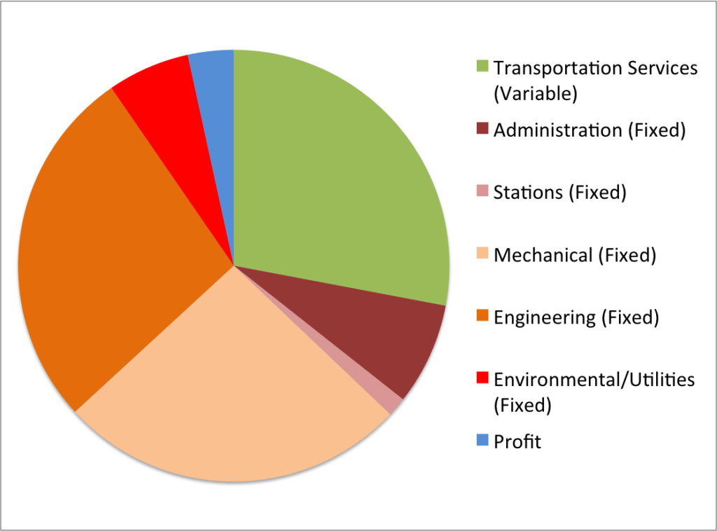
This graphic contains a footnote which reads:
“Average cost, including an allocation of fixed costs 

which may not vary if service is reduced.”

In other words, the report even goes so far as
to admit that most of the costs of operating
Commuter Rail are fixed costs, by a 3:1 margin.
Note how they bury this slightly important
information deep in a footnote that no one is
going to read.

But what are the actual costs? According to the National Transit Database, in 2013, the T’s commuter rail operated at a cost of $15.92 per vehicle revenue mile. Not train revenue mile. Vehicle revenue mile. The Cape Flyer is generally made up of nine vehicles: eight coaches and an engine (often two for redundancy; a rescue train would be hours away from Hyannis). So the actual cost of the CapeFlyer is $15.92 times 9: $143 per mile. That’s more than six times the direct marginal operational costs which are used to show the “profit” that the train apparently turns.

If the CapeFlyer had to cover all of the fixed costs as well as the marginal ones, it would be bleeding red ink, just like weekend Commuter Rail service.

And there’s the rub. The MBTA Control Board wants to nix MBTA Commuter Rail service, because they ascribe to that service the full costs of running the trains, while pointing to the CapeFlyer as an example of a “profitable” service when it comes nowhere near to covering the costs that weekend Commuter Rail is asked to cover. It is not a fair or principled comparison.

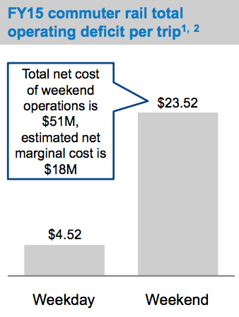
Most of the costs in running weekend Commuter Rail are fixed. The Control Board even admits this (see the screenshot from their report to the right). We already have the trains. We already have the stations. And the track, and the signals, and the crew benefits and all else. According to the Control Board documents, the average weekend subsidy per ride is $23.52. Assuming the average fare paid is in the $6 range, fares cover only 20% of the costs of running the trains on the weekends (overall, fares pay about 50% of the cost of Commuter Rail). But let’s assume that weekend Commuter Rail trains are accounted for at the rate of the CapeFlyer: $22.50 per train mile [2]. If we only count those costs, the total cost per passenger drops from $29.52 to between $4.52 and $10.33 [3]. That’s a lot less than $30, and in some cases, less then the average fare. So, using the same “innovations” that the CapeFlyer uses to turn a profit, weekend Commuter Rail service might well be able to turn a profit, too. Even if you assume that weekend service would use shorter trains (and therefore cost less) it would certainly require less than a $30 subsidy for each passenger. [4]

By not accounting for the fixed costs, CapeFlyer appears three to seven times cheaper to operate than regular Commuter Rail service. But perhaps instead of using these numbers to kill weekend Commuter Rail, we should use them to enhance it. If the CapeFlyer can show a profit at an operating cost of $22.50 per train mile, better Commuter Rail service on other lines likely could as well. Right now, with high fares and infrequent, inconvenient service (on some lines, only once every three hours!), weekend Commuter Rail ridership is low. What if we had hourly service (and perhaps lower off-peak fares) to and from Gateway Cities like Lowell, Worcester, Lawrence and Brockton? What about convenient, hourly service from Providence to Boston (which is generally faster than driving), with tourist attractions at either end of the line. And certainly hourly service to the beaches on the Newburyport and Rockport lines; lines which often fill trains in the summertime, despite the anemic current schedule.

We already pay for the track, the stations, the signals and myriad fixed overhead costs. The marginal cost of running the trains themselves—as the CapeFlyer shows—is relatively low. If we apply the accounting “innovation” of the CapeFlyer to weekend Commuter Rail service, it would be an argument to run more service, not less. If we’re going to uphold the costs of Commuter Rail with the CapeFlyer, perhaps we should try that.


A note before the footnote calculations:

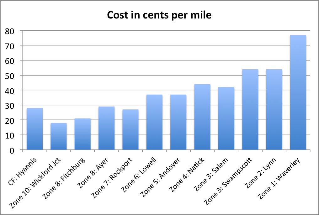
While CapeFlyer has a higher fare than any other Commuter Rail service, it is not really a “premium service.” The $22 fare for 79.2 miles works out to 28¢ per mile (cpm). For comparison, the 49.5 mile trip from Fitchburg to Boston costs 10.50 (21 cpm), but shorter trips cost a lot more—some coming in at double the cost per mile of the Cape Flyer. So higher fares do not come anywhere close to account for the difference between the “profitable” CapeFlyer and other services. There are savings available for monthly pass-holders, but this is only in the range of about 20%. Even with these discounts, any trip inside Zone 6—approximately I-495—is more expensive than the CapeFlyer.

From Keolis bid documents. 3/4 of the cost categories are fixed costs.
As is some of the fourth.

[1] This assumes 4 crew members for 8 hours including report time and layover time per day, 50 days of operation. $43/hr for an engineer, $35 for a conductor, $34 for each of two Assistant Conductors. Total direct wages of $58,476. See page 10 here for exact numbers, and note that there are a lot of other staff listed there beyond these which are not included in the calculation (nor are benefits, which account for an additional 40% of pay, but are fixed costs). A Commuter Rail train uses approximately 3 gallons of diesel per mile of operation, so 8000 train miles per year use about 24,000 gallons of diesel. Diesel prices have ranged in the past three years from $2.50 to $4 per gallon, for a cost of $60,000 to $96,000. Thus, the total crew and fuel costs range from about $120,000 to about $160,000.

[2] And, no, comparing hourly costs does not make this any different: the CapeFlyer and regular weekend Commuter Rail service both average about 35 mph.

[3] $4.52 if you compare a nine-car train like the CapeFlyer, $7.67 for a five-car train, and $10.33 according to the Control Boards own documents comparing the net marginal costs and the total costs. In theory the T should only be reporting costs for open cars during operation, but that doesn’t seem to be the case.

[4] Let’s look at this another way. A train from Boston to Worcester runs 44.5 miles. At $22.50 per hour, that means it’s direct CapeFlyer-accounting costs is almost exactly $1000. If the cost per passenger is actually $30, it would mean that only 33 people were on the average weekend train. I have taken the Worcester weekend service many times, including the (at the time) 7:00 a.m. outbound train. And there were quite a few more than 33 people on the early train outbound from Boston (more than I expected). The average weekend train carries about 100 passengers per train according to the report’s numbers, closer to 150 per train according to the T’s data (although ridership has dropped in recent years, perhaps owing to more elasticity on weekends when the train is less convenient and parking costs are lower). For what it’s worth, a CapeFlyer train only carries, on average, 130 passengers.

Finally, the T pays Keolis $337 million each year to run Commuter Rail on average—$308 million in 2015—and trains run approximately 4 million miles per year and 22 million coach miles per year. This works out to an average train length of 5.5 cars (about right), a cost per coach mile of $15 (about right) and a total cost of $84 per train mile—about four times what the “profitable” CapeFlyer costs, and that’s at the low end of the estimates.

MBTA’s Belmont cost estimates are way out of line

Belmont might be getting a new Commuter Rail station. This is not a good thing. Why? Because the T is proposing to create a new parking-oriented station which is within walking distance of far fewer customers than the current stations, and then close those stations.

Really.

In 2012, the MBTA performed enough maintenance on the platforms at Waverley Square that it required them to bring the station in to compliance with the Americans with Disabilities act. The problem? The station was built in 1952 when the grade separation there was built (the second-to-last of the B&M’s grade separation investments; Winchester was the last) and is in a deep trench, with 20 feet of steps separating the railroad from the roadway.

Now, if a sensible organization were in charge, they’d spec a new station at Waverley accessed by ramps from the street above, full-length, high-level platforms, and build a new station. On the south (inbound) side, there is plenty of room for a ramp from street level to the platform (especially since with a four-foot-high platform, you only need to descend 20 feet). The width of the south side of the station is about 200 feet, so it’s a single-zig ramp to get up and down with about three landings on each. The right-of-way, which held three tracks until the grade separation, is 100 feet wide, so the north side (outbound) platform could be accessed by a ramp to the east of the station to a rebuilt platform, with the current stairwell providing access from the narrow part of the triangle. Alternatively, platforms could be moved to the east of the station where the line is straighter, and the current station area used for vertical circulation.

In Belmont Center, the solution is easier. It would be hard to build new platforms at the current station location, which is located on a curve and would necessitate a Yawkey-style double-platform solution: a costly endeavor. However, just east of station the tracks straighten out and the right-of-way is 84 feet wide, plenty for a pair of platforms and two tracks. The north side of the station would be accessible with a ramp in place of a short staircase and a short ramp to a high level platform, which could be build to the east of the current platform. The south side would require a longer series of ramps, probably just east of the station. But again, this is not insurmountable.

But what does the T want to do? The T wants to close both stops and build a new station in between. This new station would be within walking distance of fewer residents, and much further from the downtown employment areas at Belmont and Waverley (as well as McLean Hospital, the largest employer in the town). It would have a parking lot, so a lot of people who currently walk to the train station would have to drive. It would sever connections between the bus lines which serve Belmont and Waverley and the train station. (Do you live in Waltham and work at Mount Auburn Hospital? Say goodbye to your rail-bus commute, you’ll have to take the train in to Porter, the Red Line to Harvard, and the bus out.)

Does this make any sense? If you’re a Belmont resident, it does not. Apparently, if you’re the MBTA, it does.

Here is a quick table of the current stations and their catchment areas (defined as the total population of all census blocks all of part of which are within 0.5 miles of the station location):

Belmont (current): 4311
Waverley (current): 7452
Proposed location: 7019

So not only does the proposed location serve far fewer residents than the current two stations, it actually serves fewer residents than the currently Waverley Square station!

How does the T justify this farce of a plan? The same way the justified killing the Red-Blue connector: by wildly inflating the cost of the plan they don’t want (bringing the current stations in to compliance) and giving few if any details about the costs of what they want to build. Their estimated cost for rebuilding each of the Belmont stations? $35 million (well, they’ve now come down to $16 to $30 million). Their number for a new station? They can’t say, but think it will be less. This is so entirely disingenuous it knocks my socks off.

Let’s look at some data to see how far off these numbers are, looking at some recent station construction for MBTA stations with full, high-level platforms and note whether it was a rebuild or a new station and the type of vertical circulation:

Yawkey Station (Worcester Line), 2014: $13.5 million
Existing station. built on a curve, in a narrow corridor, required track realignment, and elevators.

Boston Landing (Worcester Line), 2016, $20 million
New Station, ramps

Newmarket Station (Fairmount Line), 2013, $12.3 million
New Station, ramps.

Uphams Corner (Fairmount Line), 2007, $7 million
Existing station, ramps.

Four Corners/Geneva (Fairmount Line), 2013, $17.7 million
New station, ramps.


Talbot Ave (Fairmount Line), 2013, $15.9 million
New station, project cost included a new bridge, ramps.

Morton Street (Fairmount Line), 2006, $6.5 million
Existing station, ramps.

Blue Hill Ave (Fairmount Line), 2017, $10 million
New station, center platform, ramps.

South Acton (Fitchburg Line), 2015, $9.6 million
Existing station, elevators. The T is willing to flat-out lie about the construction costs by including land acquisition costs, which are not an issue for either station here, considering the 100-foot right-of-way.

Littleton (Fitchburg Line), 2014, $8 million
Existing station, center platform ramps.

So let’s review. Existing stations upgraded to full high level platforms built in the last 10 years have ranged in cost from $6.5 million to $13.5 million, with an average cost of $8.9 million. New stations built with full high levels have ranged from $10 million to $20 million, with an average cost of $15.1 million (the ones with elevators cost more, and elevators have higher maintenance costs). So the T is being disingenuous in two dimensions. First, upgrading the two existing stations, based on these averages, would cost only slightly more than building a new station. And secondly, recent experience shows the price would be nowhere near $35 million dollars for each station. Not even in the ballpark!

In fact, the T’s own planning documents admit this and quotes a cost of $15–$18 million for stations with side platforms (double the cost of recent station rebuilds, but still nowhere near the $35 million figure) and $22–$30 for (new) center platform stations (based on the cost of the Boston Landing station, although Blue Hill Ave is center platform and half the cost of Boston Landing). So while this planning document inflates the cost of upgrading stations, it still doesn’t get it to the $35 million level. And the claims that new stations cost more than rebuilding existing stations are just wrong.

Now, the T will claim that the new station is needed because the current stations are underutilized. This is hokum. The current stations are underutilized for two very good reasons: frequency and fare policy. First, frequency:

Inbound:
Waverley: 9 departures, 3 peak, 2 reverse commute, 4 off-peak
Belmont: 14 departures, 4 peak, 2 reverse commute, 8 off-peak
Outbound:
Waverley: 12 departures, 4 peak,  2 reverse commute, 6 off-peak
Belmont: 13 departures, 4 peak, 2 reverse commute, 7 off-peak

If you’re in Waverley and you don’t need to get to North Station at a very specific time, it’s better to take the 73 bus to Harvard and the Red Line. The 19 minute travel time is half of the bus-subway route, but it only runs once an hour. In Belmont, you have a few more choices and fewer buses, but there’s still no frequency. Schedules are uneven, and some midday trains skip the stations. Departures should be rationalized once the line has full double-tracking, but the stations won’t attract more passenger without more service. Building a different station won’t help.

Then there’s the fares. A trip on the bus and subway from Belmont to downtown costs you $2.10, or $75 for a monthly pass. A train ticket? That comes at $5.75, or $182 for the month, nearly triple the cost. This is a longer discussion about T fare policy, but it doesn’t help drive ridership in Belmont. Still, neither is an argument to build a station which will serve fewer people. (And, no, a new station won’t be an express stop: the “super express” from South Acton doesn’t even stop at Waltham.)

So what’s going on here? I’m not sure if it’s a question of incompetence or something more nefarious. But it seems to be in line with a lot of what goes on with a lot of Massachusetts infrastructure projects: create an agenda (single station in Belmont), create a plan that is unpalatable to the community (less access, more traffic) and make up costs so that your agenda compares so favorably that it is the only logical option. Then advance it far enough that it’s illogical to turn back. We saw this with Red-Blue connector, which has cost estimates the Globe has called “deliberately high.” We’ve seen it in Allston, where this page has argued that the state is pursuing a far more expensive plan by being immovable on project guidelines and refusing to fully vet better alternatives (although there is some progress being made). Unfortunately, this Belmont “plan” fits the pattern all too well.

What should we do? Contact your legislator, especially if you live in or near Belmont. Go to meetings. Raise your voice. And let the T know that they can’t get away with further degrading Commuter Rail service by making up numbers.

Part 2 takes a deeper look at these numbers, and finds them to be no less made up.

What if the Allston Viaduct was rebuilt … without a huge highway viaduct?

I’ve gone to my fair share of meetings and written quite a bit about the Allston viaduct project.

The long and short of it: $250 million for a replacement viaduct basically replicating the old one, and maybe some transit, walking and biking improvements if they can “find” the money. Everyone agrees the project has to happen: the viaduct is falling down. There are preliminary plans, and arguments over how big and wide of a viaduct to build.

But what if you didn’t build a big, wide viaduct at all? If you think outside the box (as this page has before), there’s the potential to save money. Considering how much cheaper it is to build other roads at grade, potentially lot of money. $50 million. Maybe more. The resulting highway would be safer, have better grades and sight lines, and integrate better in to potential development in Allston. It just requires a slightly change of the state of mind.

I won’t blame anyone for not realizing this earlier. I’ve been writing about this for years and it took a prompt to see if everything would fit at grade to figure it out. (The answer is you’d be about 30 feet short of lateral space to put everything at grade, and you still need to cross the Turnpike and Grand Junction.) But once you change you frame of reference, elevating the Grand Junction over the Turnpike, instead of the other way round, makes a whole lot of sense.

$250 million is a lot to spend for a mile of roadway; much of that cost is in building a high-and-wide viaduct, supports and steel and drainage, and said viaduct then costs more to maintain. This project has a lot of moving parts (bike/ped paths, Soldiers Field Road, Mass Pike, four railroad tracks going to two separate destinations) in a narrow corridor, including one (the Grand Junction branch) which has to cross another (the highway). But what if you could do it all without a hulking, expensive highway viaduct? An at-grade highway would save a lot of money. It would cost less to maintain. And it would remove the Great Wall of Allston between the river and the neighborhood.

With the state budget deficit and without increased gas taxes for infrastructure spending, we need to fully analyze projects so they are as fiscally responsible as possible. In this case, the project is necessary—the viaduct is the same age as the crumbling nearby Commonwealth Avenue bridge—but replacing a viaduct with another viaduct is far more costly than moving as much of the project as possible to grade. There is a way to do this—to build much less elevated structure—which would likely save tens of millions of dollars. We need to seriously consider it, although so far any project which does not include a large, wide road viaduct has been dismissed out of hand. That must change.

I think it comes down to priorities. With so many moving parts, there needs to be some back and forth. Certain things are immutable: you can’t get rid of the Turnpike, or the railroad. Others—what goes where, construction impacts, and the like—can be changed. So here is a rundown of priorities, roughly ranked:

  • Retain Turnpike capacity at completion.
  • Retain Worcester Commuter Rail at completion.
  • Retain two-track right-of-way for Grand Junction at completion.
  • Retain Paul Dudley White path along river.
  • Provide connectivity for a future West Station
  • Minimize cost.
  • Maximize economic development opportunities by minimizing above-grade land use for transportation infrastructure in the Beacon Park Yards area.
  • Minimize disruption to rail and road traffic during construction.
  • Improve quality of life for surrounding neighborhoods. 
  • Add width to highway to improve emergency lanes and sight lines.
  • Build a “People’s Pike” connecting the river to Allston and Boston University
  • Improve parkland along the Charles River.

The first four items are the immutable ones. A project which fails to address them is dead on arrival; Turnpike is not going to become an Arborway-like boulevard with crosswalks and bike lanes (at least not in the next 50 years). But beyond that, it gets more interesting. The most complicated piece of the puzzle is getting the Grand Junction rail line from the south side of the Turnpike to the north side. Since 1962, it has gone underneath the roadway, and perhaps because “we’ve always done it that way,” all the plans for the future have the same scenario. Yet this requires a large, wide viaduct, and those don’t come cheap. And even setting cost aside, it turns out that it might not even be the best way to build the project anyway.

If you take a few steps back, the highway viaduct just doesn’t make sense. The Grand Junction is two railroad tracks wide, or 30 feet. The Turnpike is, at a minimum, 110 feet wide. Why not put the turnpike at ground level, and build a viaduct that is one quarter the width ? Does it make sense to put the wider, higher, larger structure above the lower, narrower one? No. Elevating the Grand Junction would be far less expensive.

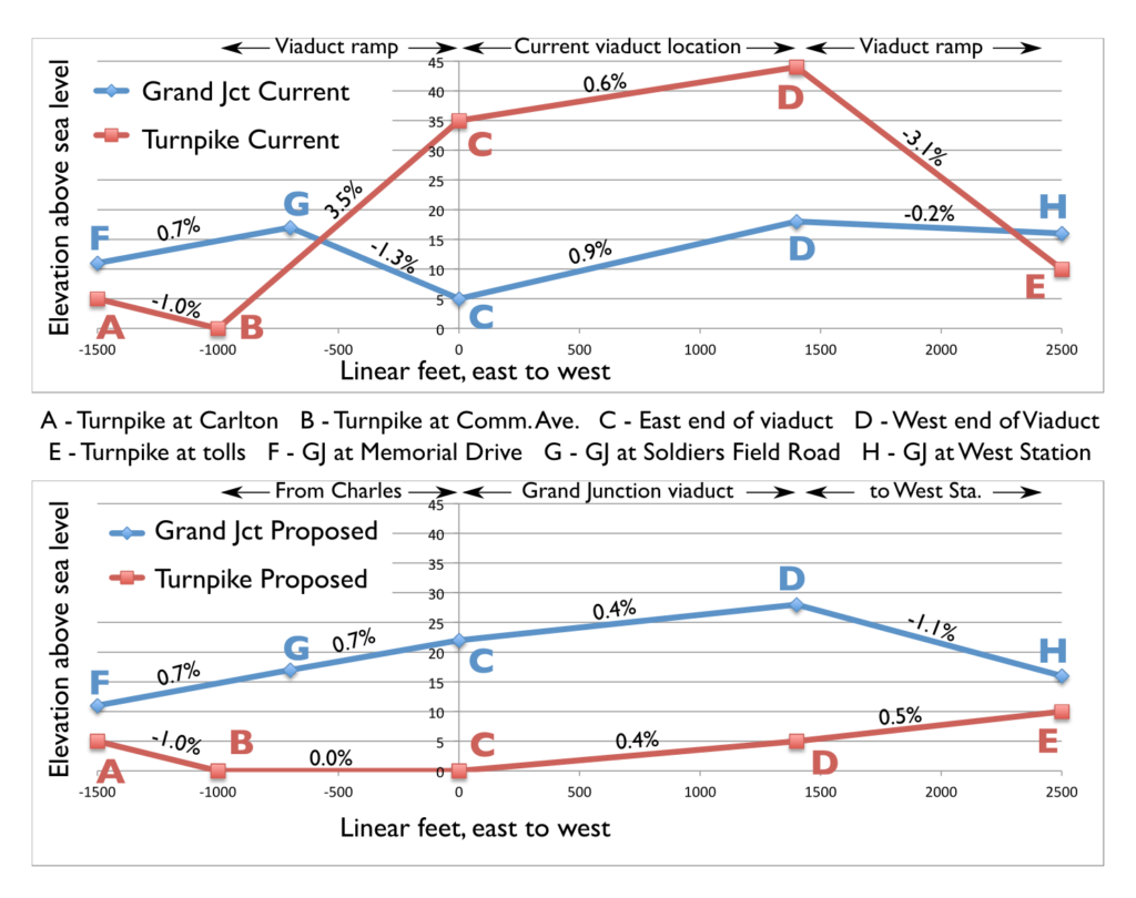
What’s more, on the eastern end of the project area, the Turnpike passes underneath Commonwealth Avenue, while the Grand Junction passes over Soldiers Field Road. 1000 feet out from the narrowest part of the corridor, where one has to pass over the other, the Grand Junction line is 16 feet higher than the Turnpike. Yet the railroad slopes down and the Turnpike ramps up, as they zigzag in vertical space to attain the necessary grade separation. From a terrain standpoint, putting the Turnpike at ground level just makes sense.

In the current setup, coming from Cambridge, the Grand Junction ascends to cross Soldier’s Field Road, and then descends sharply at a 1.3% grade to move under the viaduct. The roadway, on the other hand, ascends at a 3.5% grade to the viaduct, and then nearly as sharply at the other end to reach the toll plaza. This results in limited sight lines on the Turnpike. In the proposed Grand Junction viaduct, the ruling grade of both the road and the rail line is reduced; the rail line requires a 1.1% grade towards West Station (although this could be mitigated by slightly raising the elevation of the Worcester Line tracks), still better than the current 1.3%. And the highway has no grade steeper than 0.5% west of Comm Ave, where before it was seven times as steep, improving sight lines and safety.

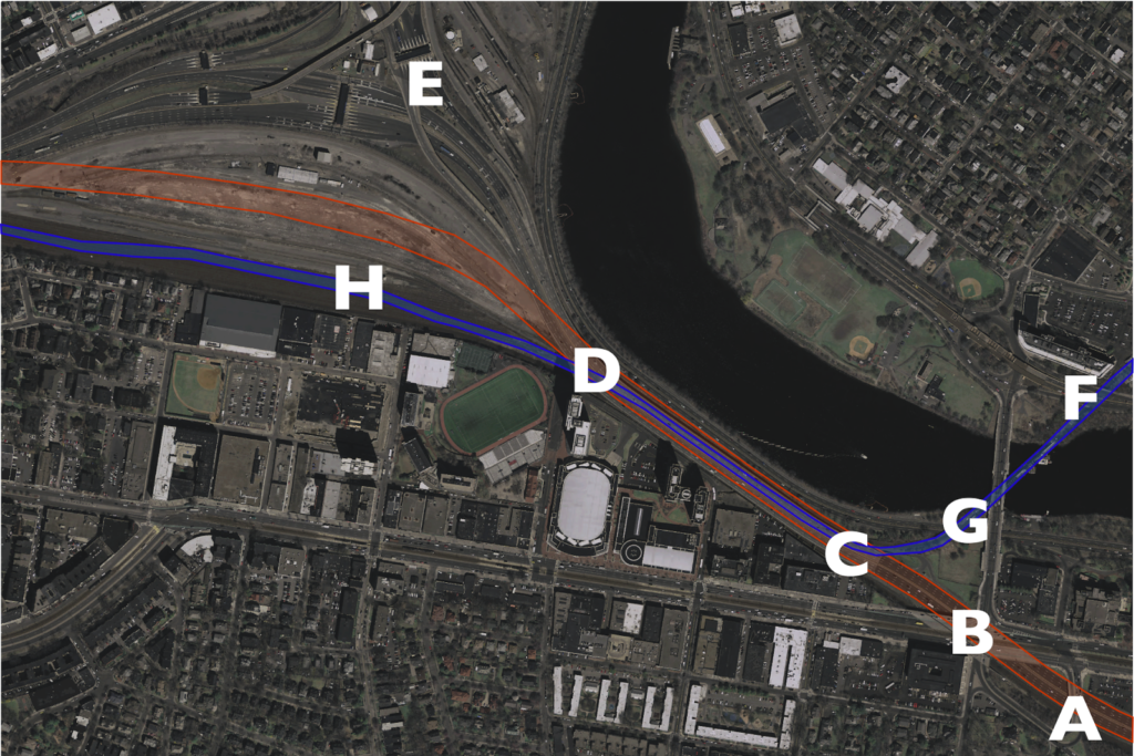
The charts below show the gradients for the current and proposed scenarios. The map below corresponds which each of the letters shown on the charts (data from MassGIS LiDAR data). Note how the Turnpike starts and ends at a lower elevation than the railroad. It makes no sense to have it resemble a rollercoaster.

What we have right now is a half-mile-long, eight-lane-wide viaduct to cross a double-track railroad right of way. It’s as if a highway were tunneled under a small stream instead of going over it on a small bridge. For whatever reason, a highway viaduct may have made sense in 1962. It doesn’t today.

MassDOT “considered” elevating the railroad, but they dismissed it as infeasible. Why? Because they assumed that all four tracks of the railroad would have to be elevated. I don’t think it’s nefarious; I think everyone’s mindset is that the highway has to go over the railroad, because that’s how it’s always been. But the Worcester tracks stay on the same side of the highway as the whole way: they can stay at ground level; there’s no need for grade separation. The Grand Junction is much easier to elevate, and requires a much narrower structure, too. Here are three slides (from here) dismissing the overhead rail line as impossible, and my annotation on each as to why it is not the case. (Click here for full size.)

One issue is that MassDOT “requires” 135 feet of highway width for full-width shoulders. While this is “Interstate standard,” waivers can be granted for constrained areas, and much of the Turnpike (including the existing viaduct) doesn’t have any such lanes. If the highway is kept at grade, it will have much gentler grades and better sight lines. This added safety will mitigate the narrow width—and such a compromise would allow for better use of the corridor as a whole.
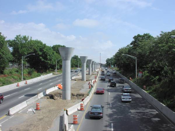
So you should kee the Grand Junction line high, and the highway low. Westbound drivers would cross under Commonwealth Avenue and then stay level. From their right, the Grand Junction line would ascend slightly—about 5 feet at a 1˚ grade—and pass on to pedestals over the center of the highway. It would continue down the center until it curved off to the left towards West Station and descended to grade. This is not a novel concept: the JFK AirTrain in New York operates in a similar manner in median of the Van Wyck Expressway. And since initial foundation work could be completed under the existing overpass early in the project, the bottoms of the pedestals and median could be pre-built with minimal impacts to traffic; less of an impact than shown here. One note: the AirTrain uses lighter vehicles than the Grand Junction, so it may require more closely-spaced supports and a somewhat thicker deck akin to what is used for other “modern” T bridges like the Eastern Route crossing of the Mystic River.  (The photo on the right is of construction of the Van Wyck AirTrain, from this site.)

Which of the following is more inviting?

Since the AirTrain is elevated above cross streets as well, it’s quite a bit higher than a viaduct would be in Allston, what a cross-section would look like from the Paul Dudley White Bike Path is similar to what it looks like when it crosses a cross street. That’s a bit less obtrusive than this. Or see below:

The photos above are actually taken from approximately the same distance away. Note how much more of the sky you can see above the Van Wyck. Wouldn’t you rather have something like the image on the right?

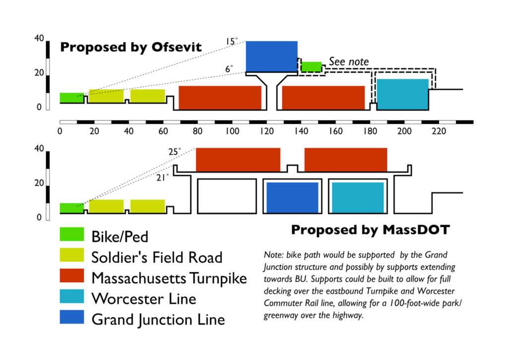
Not only is it one third the width, but it appears (and, in fact, is) lower for two reasons. In the nearby Prudential Tunnel, roads require about 14’3″ feet of clearance, trains 16’9″, so a road viaduct over a rail line is higher than the other way around. Second, trains don’t require guard rails. Put together, these add up to the top of the structure being six or seven feet lower for a rail structure. Much like how the Somerville Community Path is being built as part of the Green Line Extension, the “People’s Pike” path, it could cantilevered off the side of the Grand Junction viaduct (with additional support extending to the higher ground in—and connections to—Allston, if necessary). For an observer standing on the Paul Dudley White bike path, a rail viaduct in the median of the highway would be visible up to 6˚ in the sky, and 15˚ when a train passed over. By matching the initial grades, the highway can be lower than the Grand Junction since they don’t have to swap positions. The nearer and higher highway alternative would be visible in 20˚ of the sky, and 25˚—nearly a third of the way to vertical—when traffic is taken in to account. The smaller rail viaduct would cast many fewer shadows across the bike path and river as well.

Here is a cross section of my plans and the viaduct plan. Colors denote uses, and are scaled to the height of the users/vehicles. Scale in feet:

By elevating the Grand Junction, there is enough room for the rest of the uses:

  • 14 feet for the Paul Dudley White path (an increase from 8 to 10 feet now, narrower in places)
  • 24 feet for each side of Soldier’s Field Road, with a two foot median and two feet separating the bike path. This is the current width, and the road would need little modification overall.
  • A four-foot barrier between Soldier’s Field Road and the Turnpike.
  • 54 feet of travel space for each side of the Turnpike, enough for four twelve-foot lanes, a two foot left shoulder and a four foot right shoulder, with a six foot median where the supports for the rail line sit. Including barriers, this is 11 feet more than the current 107-foot-wide viaduct, although it is not as wide as the proposed MassDOT viaduct with full shoulders. However, by mitigating the steep grades and sight line issues, the road could be designed in this section with these narrower shoulders. With 11 foot lanes, an 8 foot shoulder could be accommodated.
  • Six feet for the concrete pedestal supports for the box-girder structure for the Grand Junction rail line, which is 30 feet wide.
  • 30 feet for the Worcester Line right of way, which would be relocated only slightly once the viaduct abutments are removed.

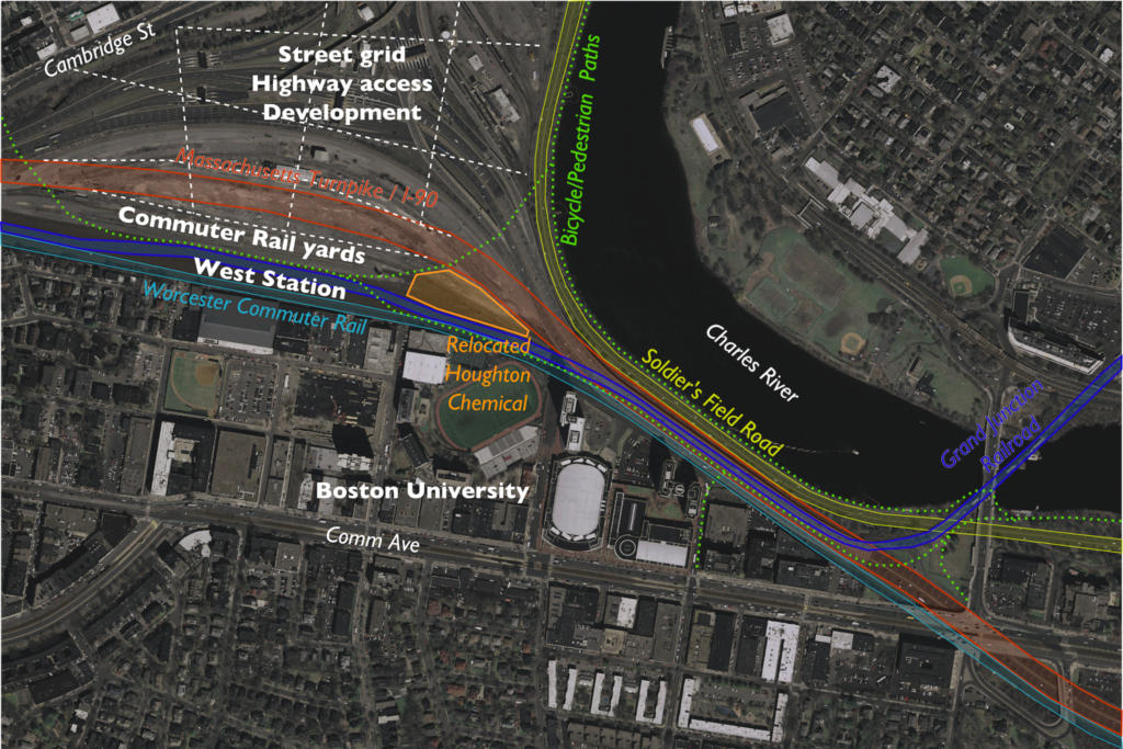
From above, it would look something like this (with just a sketch of ramps and street grid in Allston, which would built above grade):

And a focus in on the narrow viaduct area:

It would also have benefits in the Allston area. In current plans, the Turnpike viaduct has to slope gradually down through the Beacon Park Yard area. If it were at grade, it could be easily decked over, and ramps could go up to a street grid on that deck. The Grand Junction would have to descend towards West Station, but it has a much smaller footprint and would start its descent from a lower elevation, thus it would much more easily integrate in to the surrounding area.

Construction would also be much simpler, because instead of a multi-stage process where the viaduct was unbuilt and rebuilt at the same time, it would simply be unbuilt in stages, with the new roadway built on the ground below. The current staging plans call for a new, wider viaduct to be built in stages, two lanes at a time, while the old bridge is being torn down, including many temporary supports and other engineering issues. By putting roadways at the surface, you could accomplish the entire task without building any new bridging, in fewer stages (dismantling four lanes at a time instead of two), and only shoring up a few supports temporarily. It’s even possible that pedestals for the Grand Junction—which would likely be built under the current viaduct before other construction—could be used during construction to shore up the viaduct as it is dismantled.

As for the final product, rather than a 110-foot-wide, 30-foot-high viaduct, you’d have a 30-foot-wide, 24-foot-high one. The rail structure would have just 22% of the mass of the road viaduct. Road noise would be lower to the ground (with the potential for an overbuild park to cap noise all together), and the viaduct would be further from the river and from buildings at BU. And ongoing maintenance costs would be far lower. The main loss is the inability to tuck some of Soldier’s Field Road under the viaduct and create slightly more parkland in the vicinity of the viaduct. But for a cheaper project, you get a much smaller viaduct which casts fewer shadows over this area, so the bike path is a more pleasant experience.

The only major issue would be a relatively long-term closure of the Grand Junction branch, so MBTA operations and a small amount of Everett-bound freight would have to move via Ayer and Worcester. This happened recently when the Grand Junction bridge was undergoing emergency rehabilitation for several months; the biggest issue was the 10 mph speed limit on Pan Am trackage between Ayer and Worcester. (The railroad out to Worcester is Class 3 and permits 60 mph speeds, the rebuilt railroad inbound from Ayer will mostly be Class 4 with speeds of 80 mph.) With a small portion of the money saved from not building a road viaduct, that track could be upgraded to Class 2 (30 mph) trackage to save considerable time with equipment swaps and improve a freight rail trunk line as well. It would also be an opportunity to fully rebuild the Grand Junction bridge, and other portions of the corridor to Kendall Square and beyond. (One other minor issue is serving Houghton Chemical, which could be accomplished, by relocating Houghton Chemical to the other side of the highway as depicted above. In the “armpit” of the Turnpike and railroad, it would be a perfectly good site for such a use, sustain a family business in the area, and free up developable land near the river.)

Once you take a step back from the current situation and think about this, it’s obvious. It makes no sense to build a wider, higher viaduct for a roadway when you can build a narrower and lower one for the railroad. All it requires is some grading underneath the viaduct, construction that is certainly no more complex that what is being proposed. A surface roadway has a much longer lifespan and lower maintenance costs than an elevated one, and it provides a much less obtrusive—and more future-proof, as it fits in better with potential development in Allston—structure as well. It’s a better project. Best of all, given the cost differentials for projects like the Casey Overpass elimination (and McGrath and Bowker), it could probably be built for $50 to $100 million less than the viaduct, with future savings from lower maintenance costs.

That money would go a long way towards full completion of this project, mitigation steps, and ensuring the safety of other roads and bridges across the Commonwealth.

Comments on Allston

Harry Mattison, who’s leading the charge regarding the Mass Pike realignment that has been discussed for some time, asked me to reply to his email chain with some comments. I figured I’d post them here. This is what I think about the project and comments I will be submitting. Most of it is aligned with what the rest of the committee is pushing, with a bit at the end echoing some earlier ideas I’ve had. In any case, the more they hear from the public, the better, so please send comments to:

dot.feedback.highway@state.ma.us

by the close of business on Monday, September 29. You can find another example letter here.

*****

I am writing regarding the continuing planning process for the Allston Interchange project. While the project plans have certainly progressed from the originally-proposed “suburban-style interchange” (which seemed specious at the time and hopefully wasn’t a red herring to make urbanists feel like MassDOT was committed making changes), there is much work to be done. My comments will focus on several areas—overall design, development potential, transit use, bicycling and pedestrian connections and parkland—to assure that the highway utility is maintained but that this project is a positive development for the surrounding community. This is a once-in-a-lifetime opportunity to remake this parcel of land, and to connect Cambridge, Allston, Boston University and surrounding communities. Failing to do so will be a failure of the planning process, and a dereliction of duty for MassDOT in its GreenDOT, Health Transportation Compact and overall mode shift goals.

The overall design of the project as an urban-style interchange is certainly better than high, looping suburban ramps, but it has room for improvement. The footprint of the project, both in its width and height, must be minimized. For the width, a highway with “interstate standards” has been proposed for the viaduct section, with 12 foot breakdown lanes and a much wider viaduct looming over the Charles, and engineers argue that this is a requirement. This is risible. Much of the Central Artery project lacks such lanes, as does the current structure. It will certainly be less costly to build a narrower structure with less material (savings that could be used for other area improvements), and traffic and congestion in the area is caused by many factors, none of which is the width of this structure. The current structure should be the maximum width of the new project, not the minimum. West of the viaduct, the current proposal should be modified to assure that the maximum amount of the highway is built at or below grade to allow overhead use in the future. All surface streets should be built as city streets, with single turn lanes, low design speeds and provisions for bicycles, pedestrians and transit use.

Finally, the project team must have direct input from the planning, architecture and landscape architecture fields, with a focus on the emerging “placemaking” field. Even with changes, it seems that this is being viewed first and foremost as a highway project. It must be viewed as an economic development project, which happens to have a highway running through it.

It is very important that whatever the design of the final highway, it is minimally disruptive to overall development in the area. This area lies within a mile of Boston University, Harvard and MIT. It will have good highway connections, and (hopefully) excellent transit connections to much of the population and economy of Boston. The value of the land for housing, education and commercial uses will be almost unparalleled in the area, and there are certainly examples of high-value properties built overhead highways. (One must look no further than the Prudential Center for a good example.) The provisions for overhead decking should be built in to the project, if not the decking itself, which is far less expensive to build as part of a brownfield construction project than an existing highway. This decking should, if possible, extend over the rail corridor as well (Back Bay Station would be an example here, as would many New York City Transit properties). With more and more residents wanting to live in transit-accessible areas, we should assure that potential housing properties are kept as easily built as possible.

As this area grows, it could become the next Kendall Square: a nexus of education and technology. Currently, the rail yards and highway produce minimal tax revenue for the City of Boston, which has to deal with the air and noise pollution they create. Allowing maximum development potential here should be a priority for the Commonwealth, to allow the city future tax revenues from development here. Cambridge residents enjoy low property tax rates due to the many businesses in the Kendall Square area; extending this to Allston would benefit all of the residents of the city. Many international companies have relocated to Boston and Cambridge, and we should give them every opportunity and location to do so. The Boston Society of Architects has had some great examples of this type of development potential here.

Transit must be a priority for this project, not an afterthought. The oft-mentioned West Station should not merely be a design element of this project, it should be built as part of the project, if not before the mainline of the roadway. Further development of this area will not take place because of its proximity to a highway; transit access will drive growth in the 21st century. West Station must be built with a minimum of four rail tracks to serve both the burgeoning Worcester Line as well as potential service on the Grand Junction. The state is spending millions of dollars improving Worcester service and expanding the number of trains, and a West Station service current uses (steps from Boston University) and future growth is a must. The Grand Junction Line must be built with two full tracks for potential future service; it’s ability to link Allston, Cambridge, North Station and beyond (and by doing so, provide much better connections for travelers from west of Boston wishing to get to Cambridge, the cause of much of the surface traffic in the area) should not be understated.

In addition, the plans must have provisions for future north-south transit in the area. Currently, travel from Boston University to Harvard Square requires 40 minutes and a minimum of one transfer, often with travel through the congested center of the subway network. New traffic patterns should allow for a direct connection between BU and Allston, continuing on the south end to Kenmore Square or the Longwood Medical Area, and the north side to Harvard Square. While there are certainly valid arguments that heavy car traffic should be precluded from this area, transit service should be prioritized. A transitway from the Packards Corner area via West Station to Harvard Street would fulfill objectives of the Urban Ring, as well as allow much better connectivity through the neighborhood. This should be planned with signal priority over other vehicular traffic, the potential for future grade separation, and the potential for conversion to light rail so as to meet up with the Green Line on Commonwealth Avenue. Imagine, a Green Line branch from Cleveland Circle to Harvard Square via Commonwealth Avenue and Allston. This would certainly be possible in the future if we design the appropriate rights of way today.

In addition to transit, bicycle and pedestrian travel must be well-integrated in to the project. The recent concepts put forth have certainly improved original plans, but, again, bicycle and pedestrian infrastructure should be a priority, not an afterthought. Pains should be taken to assure that routes are safe, adequately wide (a minimum of 25 feet wherever possible) and direct, with minimal street crossings. A well-built bicycle and pedestrian network will make trips which are currently convoluted, roundabout and/or dangerous much more desirable, and certainly allow for better connectivity and attaining mode shift goals by shifting travelers away from cars. Other existing and future human-scale corridors should be designed for maximum efficiency in moving people without cars. Within a 30 minute walk of this area are many of the leading health, education, science and commercial institutions in the world. They should be accessible without sitting in traffic.

This project parallels the Charles River, and surround park land must be a priority. From the Charles Dam to the Eliot Bridge and beyond, much of the DCR parkland is taken up by high speed roadways. We have turned our back on the river in the name of moving vehicles, and this is something we should begin to take steps towards mitigating. This project will give us a good first stab at that. As mentioned above, no parkland should be sacrificed for a wider viaduct: we have seen too much green space appropriated as pavement in the past generations. Soldiers Field Road should be migrated as far away from the river as possible, creating a promenade or “Allston Esplanade” similar to what we have further to the east, which should connect with development alongside and above the highway. The current bike path, which is, at places such as the River Street Bridge, less than five feet wide (well below any reasonable safety standard) in the name of keeping car traffic moving must be changed: we should no longer throw the safety of cyclists and pedestrians to the wind in order to make traffic flow better. It is laudable that MassDOT is working with the DCR: they should be included in this process going forward.

Furthermore, there is a dramatic opportunity to work with Harvard to move Soldiers Field Road away from the river across a much longer distance, and in turn create one of the premiere riverfront parks in the country. This would entail looping Soldiers Field Road west of Harvard’s Business School campus and the Harvard Stadium, likely in a below-grade facility to mitigate the impact on the neighborhood there. However, without sacrificing any capacity and allowing shorter distances for motorists, it would allow the DCR to decommission the roadway between the Eliot Bridge and the Allston project site, allowing a wide, linear park to form along the river, benefiting not only local residents, but all residents of the Commonwealth. (A rough outline of this plan can be found here.)

The Allston Turnpike project is an opportunity to shape the entire region for the next 100 years. We must assure that all plans allow for the maximum future development. Again, this is not merely a highway project: it is a long term development project which we must allow to have positive returns for the Commonwealth’s economy and quality of life.

Tolls, traffic and unintended consequences

Back in 1996, Governor Bill Weld wanted to be Senator. John Kerry was running for his third term. Amidst the clash of blue-blooded New Englanders, Weld decided it would be a great political coup to remove tolls on two sections of the Massachusetts Turnpike. So he zeroed out the tolls in Western Mass (which mainly required new tickets—yes, that was pre-EZ-Pass—as the highway still required toll barriers; the tolls were reinstated last year to little fanfare) and nixed the toll in Weston Newton. While the Western Mass tolls were a quiet affair, the West Newton tolls were less so.

Overnight, signs went up: Toll Free. One day when I was biking home from middle school (yes, middle school, and yes, I was a commie bicyclist even then!) I noticed a peculiar sight: a backhoe was tearing in to the old toll booths, and within a few days they were gone, paved over would never be seen again. Of course, this was a transparent political ploy, and it soon surfaced that Weld hadn’t publicly bid the demolition contract but instead given it to a friend. He lost the election by seven points. 
And overnight, he created a nearly-twenty-year-long traffic jam. (Yes, this was predicted by some at the time, although the Globe article is archived so you need a login, and yes, all of this really happened.)

Much of the traffic coming east on the Turnpike originates on Route 128. When the Southwest and Northwest expressways were canceled, the Pike became the only western trunk route in to the city. Up until that point, the toll to access the Turnpike at 128 was 50¢, and in West Newton it was 25¢. Traffic from the south on 128 has little incentive to stay on 128 to the Turnpike, as the diagonal Route 16 is two miles shorter and, even with traffic lights, negligibly slower, especially given the roundabout design of the 90/128 interchange, where Boston-bound motorists drive half a mile due west before swinging back east through the toll gates. Until 1996, there was a 25¢ difference between staying on the highway and taking the surface roads. In 1996, the savings went to 50¢, and when tolls were raised in 2002, to $1.00 (it stands at $1.25 today). This was a four-fold increase in the direct cost savings over those six years, and there was suddenly a much higher incentive to take the Route 16 shortcut and save a dollar.

And guess what happened on Route 16? Traffic tripled, and gridlock ensued. Exit 16—coincidentally, where Route 16 intersects the Turnpike—was never anticipated to be more than a local access exit. It has a short acceleration zone and a very short merge with poor sightlines around a bridge abutment. And it began to handle far more traffic than it had before. (On the other hand, the outbound ramp no longer required vehicles to slow through the toll plaza, and they frequently merged in to Washington Street at highway speed at a blind corner with significant pedestrian traffic.) With more cars coming off of Route 16 rather than the main line, it created a merge which caused traffic back-ups a mile back Route 16, and—given the merge—also backed up traffic on the mainline of the Turnpike. Additionally, drivers who may have, in the past, stayed on Route 16 between West Newton and Newton Corner instead used the free segment of highway, adding to the traffic along the Turnpike and causing more backups at the short exit ramp there. One shortsighted, unstudied policy change changed the economic decisions of drivers on several segments of road, changed the equilibrium, and caused several different traffic jams.

And the state lost money, to boot.

So the new electronic toll can’t come soon enough. It’s too hard to tell if it will rebalance the traffic, or if growing traffic volumes in the intervening 18 years have created this traffic in any event. But it will finally correct a problem nearly two decades in the making by a governor trying to score political points; a problem that never should have occurred in the first place.

Why does going to Amherst require a transfer?

This past weekend, I was trying to get from Hartford to Amherst. This should be a reasonably easy trip. Peter Pan Bus runs about a dozen trips daily between Hartford and Springfield and eight between Springfield and Amherst. I went looking for tickets, figuring that at least some of those trips would be through-runs. All required a transfer in Springfield. Which is odd, because to get from Boston to Amherst—except for Fridays and Sundays during the academic year—also requires a transfer.

It got me to thinking: can you get to Amherst by bus from anywhere further than Springfield without a transfer at the decrepit-if-soon-to-be-replaced Springfield bus station? It took some reverse engineering of the bus schedules (update: somewhat available in PDF here), but I am pretty sure the answer is a resounding “no.”

This is a problem. It is an issue both in the time it takes to get from Boston to Amherst with a transfer—generally more than three hours for a drive which would be a direct trip of 1:45—and the psychological effect that people do not like to have to transfer (especially if they have to sit in a post-apocalyptic bus station that hasn’t seen a broom since the mid-’70s). There is research about transfer penalties in transit, and it is likely that this carries over to intercity bus travel as well.

Amherst to Boston should be a strong bus market, even at times when undergraduate students aren’t decamping for home on the weekend. Amherst to New York City should also be a well-traveled route. In theory, one bus could start in Amherst and run to Springfield an on to Boston in 2:00, with a transfer available to Hartford and New York. In practice, there is minimal schedule coordination, and every passenger is required to get off of one bus, wait in the bus terminal, and get on to another. By imposing a penalty which doubles the travel time (to Boston) and requires a transfer at a substandard bus station, it discourages students to use the bus system, and indirectly encourages them to use a private automobile, despite $4 gas and tolls.

I ran some times for these routes on a weekday (I chose May 7). The average transfer time for a Boston-to-Amherst trip is 27 minutes. The average transfer for a New York/Hartford-to-Amherst trip is 40 minutes. Departing Amherst the transfer times are a bit better: 20 minutes to Boston and 28 to Hartford/New York. But it still incurs a significant time penalty, and a significant issue of not having through service.

There is a model for this sort of service: Concord Coach’s service from Boston and Logan airport to Portland Maine and beyond. Several times a day, two buses leave Boston and Logan and run to Portland. Since the market beyond Portland is smaller, only one bus is needed to go beyond Portland to Augusta and Bangor. The bus which originates in Boston runs through, and passengers coming from Logan and who wish to go beyond Boston get off one bus and on to the other. The transfers are timed for minimal delays, and the buses will wait for each other if one is running late.

Peter Pan’s service could mirror this from Amherst. Buses would leave Boston and run to Springfield, a major market. At the same time, buses from New York to Springfield would be coordinated to arrive a few minutes before the Boston bus. Those passengers would still transfer if they wanted to travel beyond Springfield—and a few minutes of schedule padding could be built in due to traffic conditions south of Hartford (with more frequent service to come on the New Haven-Hartford-Springfield rail corridor, train services could be synched with bus service as well). Boston passengers to Amherst would stay on the bus, and instead of a 10 to 30 minute transfer, it would necessitate a five minute stop.

This would mean that passengers from Boston to Amherst would see significantly shorter trips and would no longer have to move from one bus to another. If Peter Pan claims that there is not enough demand for the market, perhaps it is because their service is substandard on the route. For anyone who has taken a bus to Amherst it’s a joke that you have to change in Springfield. In reality, it is a detriment to service.

A major stakeholder in this should be the Commonwealth of Massachusetts. They operate, in Amherst, a major research and educational institution, which should have strong ties to Boston. There’s no direct highway access to UMass; driving between the two requires an indirect trip via Springfield and Northampton, or a narrow road from Palmer. The state also, through it’s BusPlus+ program, subsidizes Peter Pan routes, buying buses for the operator in exchange for Peter Pan’s operation of commuter routes. MassDOT should, as part of this relationship, encourage Peter Pan to run direct service between Amherst and the three largest cities in the state: Boston, Worcester and Springfield. Not doing so is a disservice not only to the traveling public, but also to the state’s major public university. It’s nonsensical that you can’t get on a bus in Amherst and get to Boston. That could—and should—change.