The case to kill the Needham Line (and replace it with Rapid Transit)

Everything is interconnected.

That should be the lesson of any transportation infrastructure project. Everything moves together. One part is always related to another. A change to one piece of infrastructure may have effects—positive or negative—across modes, across time, and across a region. In some cases, a project in one area can have a major impact on a seemingly disparate project somewhere else. We can’t think of transportation projects in a silo; instead, we must think of everything is interrelated.

South Station Expansion: Supply vs Demand

Which brings me to the South Station Expansion (SSX) project. This behemoth is a decade-long (or more) project of dubious value. Of most value is rebuilding the Tower 1 interlocking, which, when it fails, has huge service impacts for the entirety of the south side Commuter Rail network, impacting tens of thousands of commuters. Of more cost, and less apparent benefit, are plans to buy the post office building and build more tracks at South Station. SSX poses the current capacity issues at South Station as a supply problem, and therefore sees the solution to build more supply. But what if, instead, we addressed the demand?

There are two ways to think of the demand at South Station, and how to mitigate it. One is to look at the time which it takes each train to platform, let passengers off the train, have the crew change from one end of the train to another and perform a brake test, and board passengers for the destination (the passenger movements and crew end change can happen simultaneously). Right now, at rush hour, there is a maximum of 20 Commuter Rail trains per hour at South Station, spread across 11 tracks used for Commuter Rail (the other two are used for Amtrak). This means that the average occupancy time of a track at South Station is 33 minutes. 

This is not exactly good. At outlying terminals, trains frequently turn in as little as fifteen minutes; most Worcester Line trains, for example, spend 20 minutes or less from the time they arrive at an outlying terminal to the time they leave. Even taking into account higher passenger loads at the terminal station and the need to empty the train before refilling it (given the width of the platforms), as well as extra time to traverse Tower 1, something less than 33 minutes should be possible. Let’s assume that an average turn time of 25 minutes were feasible at South Station. This would allow 26 trains per hour to use the terminal’s 11 Commuter Rail tracks, a 30% increase over the current “capacity” without building a single new track.

There’s another way to look at SSX as a demand issue rather than a supply one: run fewer trains into the station. In most cases, this is a non-starter: the trains which run into the station are near or at capacity, so running fewer would cause more crowding and provide less service; even if longer trains were run where possible, they would be even more infrequent than the service provided today. There is an exception: the Needham Line could be replaced with rapid transit service and removed from South Station entirely, freeing up 10% of the capacity there without lifting a finger, at least on the Commuter Rail side. Reducing demand to preclude building more supply could save billions of dollars, and while converting the Needham Line to rapid transit wouldn’t be cheap, it might be significantly less expensive than South Station Expansion.

Needham Line Replacement

Other than the Fairmount Line, the Needham Line is Commuter Rail’s shortest. It runs less than 14 miles, splitting off of the Northeast Corridor at Forest Hills, running through Roslindale and West Roxbury to Needham Junction, and then curving back northeast to Needham Heights. (The track beyond there originally connected to what is now the Riverside Line.) The end of the line at Needham Heights is less than 10 miles, as the crow flies, from Downtown, closer, in fact, than the Green Line terminus at Riverside. Yet a train to South Station takes 46 minutes to complete the journey, making frequent stops between Needham and Forest Hills. Service is infrequent—about every 40 minutes—yet the line is still so crowded that it sometimes leaves passengers behind. This is probably because a typical rush hour commute time is even longer: the trip from Needham to Boston by car can take well over an hour.

This page recently detailed how a mile-long extension of the Orange Line to Melrose could, for a small investment, dramatically improve the service. Replacing the Needham Line would be a similar endeavor, albeit one at a larger scale. It would involve two line extensions, extending the Green Line south from Newton Highlands to Needham, and the Orange Line west from Forest Hills to West Roxbury. Most Needham Line riders would see slightly longer trip times to downtown Boston, but this would be made up for by dramatically-increase capacity, significantly shorter waiting times and much more frequent off-peak and weekend service (the Needham Line doesn’t operate on Sundays). It would also have cascading benefits throughout the regional transportation network.

Orange Line Extension to West Roxbury

Extending the Orange Line to West Roxbury would be a relatively simple project, as far as rail extensions go. Southwest of Forest Hills, the Orange Line terminates in a small, four-track yard, where trains can be stored temporarily at the end of the line. This yard happens to be adjacent to the Needham Line tracks, which extend to Roslindale and beyond. While it was originally a two-track right-of-way, the current Needham Line operates with a combination of single track and dual track, with most stations on the single track portion. Any conversion to rapid transit would require double-tracking of the line, which is generally easy in the existing right-of-way, except for two bridges in Robert and LaGrange streets, which have wide bridge abutments, but only a single trackway. 

A trip to Back Bay station would take two or three minutes longer on the Orange Line than it does today on Commuter Rail, but rather than a train once every 40 minutes at rush hour and every two hours midday and Saturdays (and no service on Sundays), trains would come every few minutes, all day long. Given the current fare structure and the infrequency of service, many passengers would shift from taking a bus to Forest Hills and changing to the train there to a direct train trip, freeing up buses to be used on other routes in the region. 

The largest cost in converting the line to rapid transit would be from the development of stations, which would generally have to be rebuilt with new platforms and vertical circulation, as few are ADA-compliant and some rely on pedestrian grade crossings, which are not feasible with third-rail power systems. The four new stations would replace the existing Commuter Rail stations, although it may be possible to consolidate the West Roxbury, Highland and Bellevue stations, which are less than half a mile from each other. The line may benefit from having a new station to the west near the VFW parkway. This would provide access to new housing developments there, the potential for a park-and-ride facility, and a station within walking distance of the VA medical center there, which is currently difficult to reach by transit and surrounded by a sea of parking. There are also several parcels of low-density strip malls which could be redeveloped as transit-oriented development (like this one), increasing ridership at the station as well as providing much-needed housing for the region. (There’s also a major electrical substation there, which would provide power to the line.)

West of there, there may be need for a small storage yard along the current right-of-way, especially if additional vehicles were needed to provide service (the Orange Line fleet as constructed today can barely keep up with current demand, but the new expanded fleet will allow more frequent service). The right-of-way across the river could be converted into a multi-use path, extending west across the Charles, through Cutler Park to Needham Junction, the Green Line extension, and the path southwest to Dover and beyond.

Why not extend the Orange Line further west? One is technology and the line’s profile: it would only be able to run as far as Needham Junction, north of which there are grade crossings incompatible with third rail electrification. It would require rebuilding three long bridges across the Charles, a drainage in Cutler Park and 128, which are currently single-tracked, and dealing with the current grade crossing in the golf course west of Hersey. But mostly, it’s because the population profile. The stations in Needham serve a much less dense population than those in Boston, and extending the Orange Line two miles across a park to serve Hersey and Needham Junction would be far more expensive than using the Green Line, which is needed in Needham because of the grade crossings there.

Green Line Extension to Needham

The outer portion of the Needham Line, from Needham Junction to Newton, looks very little like the line in West Roxbury. Today’s Needham Line is made up of three different railroads, a branch of the Boston and Providence to Dedham built in the 1840s, the Charles River Railroad built in the 1850s, and the portion between West Roxbury and Needham Junction, built in the early 1900s. While the B&P was grade-separated, the Charles River Railroad was not, and there are eight grade crossings between Needham Junction and Newton Highlands. This lends itself far more to a light-rail operation, with overhead power and smaller stations. Luckily, the Charles River Railroad split off the Boston and Albany’s Highland Branch at Newton Highlands, and the Highland Branch is today’s D Line.

Extending the D Line the first mile to Oak Street would be simple. The right-of-way is 85 feet wide, plenty wide enough for two Green Line tracks and the parallel Upper Falls Greenway (a 2017 document suggests there might be some areas which would require additional retaining walls, although the width of the corridor can easily accommodate two tracks). There are no grade crossings, existing mixed-use areas, and significant opportunities for further development in the corridor. The costliest item may be building a junction between the lines past Newton Highlands.

West of Oak Street is trickier, as bridges over both the Charles River and Route 128 would have to be widened and replaced. The bridge over the Charles is a single track, while the bridge over 128 was removed during the wildly expensive “add-a-lane” project (originally, the scope included rebuilding the bridge, but it was deleted out as a cost-saving move; although MassDOT would be responsible for restoring the bridge if the MBTA requested it, theoretically using highway funding; abutments are built to accommodate two tracks). From there, the right-of-way extends in to Needham, where it eventually joins up with the existing Commuter Rail line. Grade crossings would have to be added and power run (there is an existing substation adjacent to the line at the junction with the current D Line, as well as high voltage power at Needham Junction) and stations built, although grade-level, Green Line stations would be far less costly than those on the Orange Line, since they would consist of little more than concrete platforms and shelters. If retaining service to Hersey was desired, it could be served by a single-track extension from a terminal at Needham Junction (and theoretically, a single track Green Line would make more sense for a line from Needham to West Roxbury than Orange Line service, if service were desired along this leg).

The trip from Needham to Downtown Boston would be five to ten minutes longer than the Commuter Rail trip (more of an impact from Needham Junction and a minimal change from Needham Highlands), although improved Green Line fare payment and boarding may help speed trips on the line. There would be a major advantage for trips to the Longwood Medical Area, however, since the Longwood Green Line station would be just 25 to 30 minutes from Needham, and it is located significantly closer to the major employment center there than the Ruggles stop on the Commuter Rail is today. And, of course, trains would run every eight or ten minutes, as compared to the less-frequent Commuter Rail service today.

Since everything is interrelated, the biggest obstacle to this project may actually be the core capacity of the Green Line subway in Back Bay. From Copley to Park, there is a train every 90 seconds, which is close to the capacity of the line. While the MBTA has proposed adding longer vehicles to the line to increase capacity, adding a branch to Needham might overload the central subway system, even if service to each of the sub-branches (Needham and Riverside) were cut to every 8 to 10 minutes at rush hour, it would put more pressure on the line. There is, however, an escape valve. The design of the Kenmore station would allow some trains to terminate there, loop over the main trunk of the subway, and turn back outbound, without impact the Copley-Park segment. While this would incur a transfer for some passengers, they could board any other train in the station and continue their trip (and any passenger going to a destination west of Kenmore, like the LMA, would have no impact). This would allow service on the Riverside and Needham branches to maintain high frequencies without adding congestion downtown. (There are other solutions as well, but may be significantly more capital intensive than this, which would be free.)

Green Line Storage Capacity

A major benefit, however, would be the ability of the Needham extension to provide additional rail car storage for the Green Line. Once the Somverille Green Line extension opens, the line will need additional cars, and if the fleet is upgraded from 75-foot cars to 100-foot cars, as is proposed, the current storage facilities will be unable to cope with the number of cars on the line. (Of course, if service were run 24 hours each day, enough cars would be operating on the line as to reduce the need for more storage.) Cars are currently stored at Riverside, Reservoir, Lake Street (at the end of the B Line) and at Lechmere. The Lechmere yard will be replaced with a new facility as part of the Green Line extension project, but there are otherwise few areas to expand train storage, and the Needham Branch would require more cars, and more storage. 

Needham Junction, however, provides that room. The current Riverside yard provides storage for 6000 linear feet of railcars, which accounts for about half of the space in the yard (the rest is the T’s heavy maintenance facility for the Green Line). Needham Junction could easily accommodate that size of facility (see a comparison here) and, if expanded to fill out the wye there and the adjacent power line right of way could store triple the amount, enough to store the entire current fleet (including the forthcoming Type 9s), so certainly enough to provide additional capacity for future fleet needs. Part of the site could also be used as a park-and-ride lot or for transit-oriented development (the portion not already owned by the T is owned by a landscaping company).

Overall Benefits

Extending the Green and Orange lines to Needham and West Roxbury would be a major undertaking: a multi-year project which would cost hundreds of millions of dollars. And yet, its effects would be felt far outside of Needham and West Roxbury. It would provide:

  • Much more frequent service for Needham, West Roxbury and Roslindale commuters 
  • More capacity at an unexpanded South Station, to add service to other Commuter Rail lines, and the ability to push back the huge expenditure required to add capacity to South Station
  • Additional “slots” on the Northeast Corridor, to allow more service on this particularly-constrained portion of the Commuter Rail.
  • Additional storage for Green Line trains
  • More bus service in the entire region, since many of the bus routes currently serving Forest Hills could be reduced in frequency (given the Orange Line in West Roxbury) and cut back from Forest Hills to Roslindale or other Orange Line stations. The buses saved could be reallocated to other parts of the system. In addition, the 59 bus in Newton and Needham could be truncated and replaced with the Green Line.
  • The reallocation of the three Needham Line Commuter Rail train sets, which would add capacity to the rest of the system and/or allow some of the most antiquated trains to be retired.
  • A new greenway path connecting the ends of the Orange and Green line extensions to Cutler and Millennium Parks, across the Charles River, and south and west to Needham Town Forest and parks and conservation areas beyond.

Thus, extending the Green and Orange lines will not just benefit those along the Green and Orange extension routes, but also people riding buses, people riding the rest of the Green Line, and people riding Commuter Rail, as well as allowing the state to push back the need to build out the South Station expansion, and potentially explore opportunities to further address the demand side (by reducing turn times further or building a North South Rail Link) instead.

The case for extending the E Line to Hyde Square

This post was conceived of and co-written by an author who wishes to remain anonymous (I know who he/she is and fully support the content in the post).

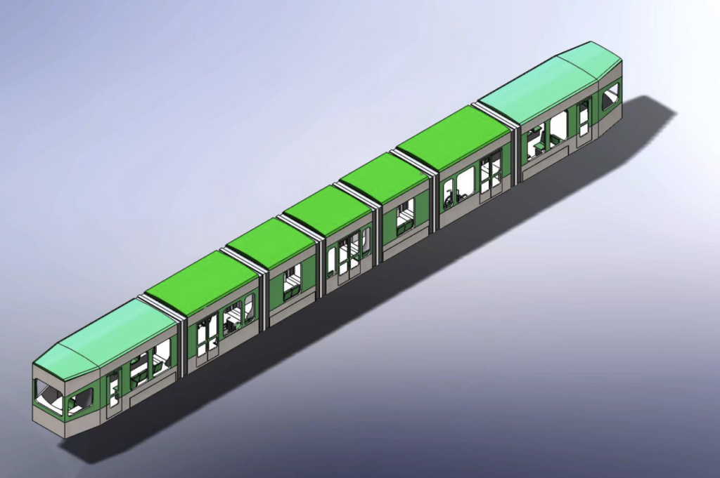
The proposed design for the new MBTA vehicles.

With the news that the MBTA Fiscal Management and Control Board is considering a massive revamp and modernization of the Green Line, including modern rolling stock, comes the necessity to consider the future of the E Branch. Additionally, the MBTA’s Focus40 plan for the next 20 years of the MBTA makes several recommendations for the E line, in particular, which we think could be implemented relatively easily and inexpensively, and would allow the T to provide better, more efficient service in the corridor.

However, the E branch, with its street-running segments in heavy traffic and simple loop terminal, poses a problem. Should the FMCB choose to modernize the system and acquire 100-foot-long cars, two-car trains of the new rolling stock will be unable to fit into the existing Heath Street Loop, one of the smallest on the system once the Lechmere Yard is decommissioned with the coming completion of the Green Line Extension project. This would limit the capacity of any trains serving the E Line, including in the Central Subway and the GLX.

In part as a result of the MBTA’s past lack of transparency about the Arborway line, the future of the E Branch is a touchy subject and a source of frustration for many. There are some in Jamaica Plain would obviously like to see the line extended back to the Arborway, but this is unlikely. This is due to the existing reliability issues on the mixed-traffic segment and the unlikelihood of gaining high-quality dedicated right-of-way on Centre Street (where the 39 bus suffers reliability issues) and which has a narrow cross-section which is, in certain points, just 40 feet wide (narrower than any existing streetcar line in the country with the exception of two blocks of the J-Church on 30th Street in San Francisco, where, it’s worth point out, it doesn’t snow), so a full-scale restoration still seems unlikely. Indeed, the E branch is the first line to be cut when the T runs short of vehicles; recently it has been relatively frequently terminated at Brigham Circle during the evening rush on some days, apparently due to a shortage of operable trolleys (or as the T’s Twitter called it: “disabled trains“). The T has been less than transparent about this, raising bad memories of the Arborway Line’s “temporarily suspended” days, which began in 1985 and lasted for decades (unlike the final 1985 shutdown, service has generally been restored in the evening).

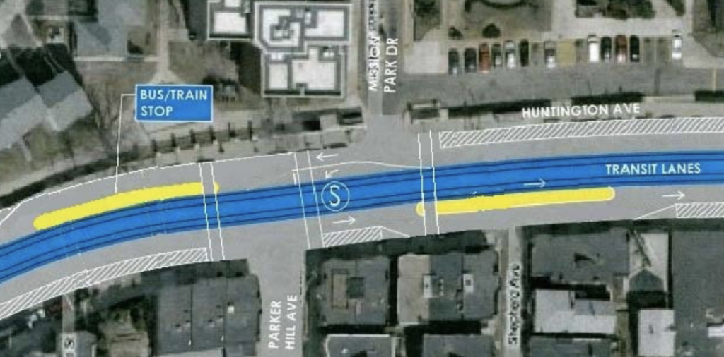
Despite the state of the E Branch beyond Brigham Circle, and the challenges facing it in a modernized future, ideas for its improvement continue to pop up. The line is mostly constrained by a short section of street running near Brigham Circle, where the E Line shares right-of-way not only with the congested Huntington Avenue leading from Route 9 to the Longwood Medical area, but also the frequent 39 and 66 buses. Northeastern transportation professor Peter Furth and then-student Charlie Guo put together a proposal to create a dedicated transitway through this section, a corridor—and major bottleneck—identified by CTPS analysis as one where transit riders represent a high percentage of road users at peak hour. Meanwhile, the Go Boston 2030 plan suggests extending the branch, not all the way back to the Arborway, but to Hyde Square in the northern part of JP.

The Furth-Guo proposal on Huntington Ave.

Between the recent rush-hour cutbacks and the challenges that any proposed Green Line modernization would pose to Heath Loop, it is likely that if the E Branch is to survive beyond Brigham Circle, it is in need of a plan for modernization and improvement itself. Such a plan must satisfy several elements. It should:

  • Preserve reliability for the entire E service. Unreliablity west of Brigham Circle can cause cascading delays down the line, which will become more problematic as the line is extended to West Medford.
  • Be compatible with modern rolling stock
  • Adequately serve, or even improve, the needs of current riders on the E Branch and the parallel 39 bus
  • Increase overall capacity to meet the needs of the considerable development on the Huntington Avenue corridor

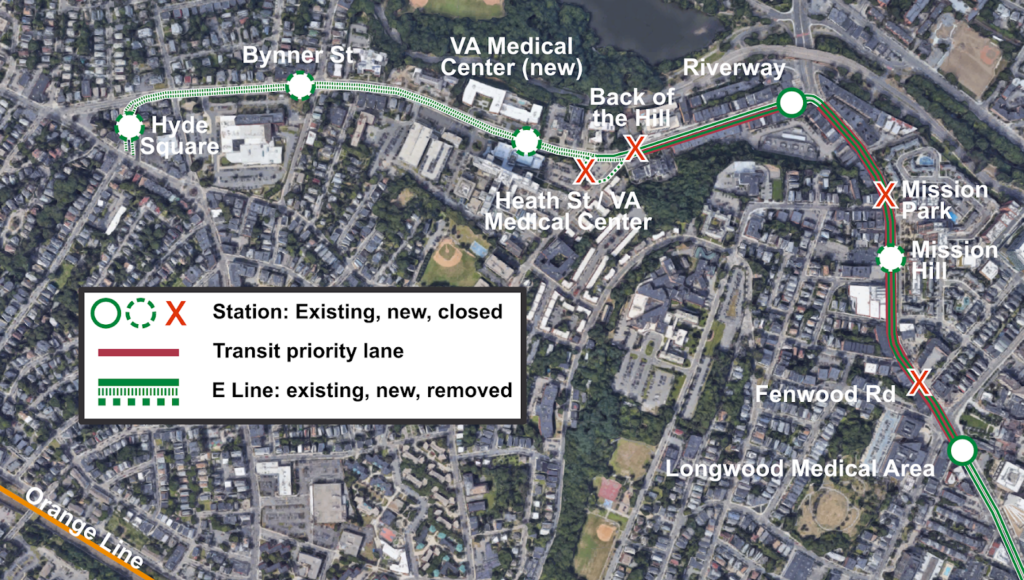
This post seeks to to combine the Furth-Guo proposal with additional dedicated right-of-way on South Huntington Avenue and follow the City of Boston’s proposal to extend the E to Hyde Square. Such an extension would likely involve some rearranging and consolidation of stations, not only in the section between Tremont and Riverway as in the Furth-Guo proposal, but additionally on South Huntington.

This Huntington Transitway would have several beneficial features. It would be designed to serve both trolleys and buses; since the E will likely never be restored beyond Hyde Square, there will always be a necessity for a frequent bus serving the Centre Street corridor. As such, while a center-running configuration is clearly preferable on the Tremont-Riverway section, a side-running configuration might be preferable on portions of South Huntington. This is particularly the case on South Huntington approaching the right turn on to Riverway, where the left lane, which is used by left-turning traffic and streetcars, is often congested, while the right lane flows freely. It would also allow an accessible, level-boarding station for trolleys and buses to be built integrated into the sidewalk.

While the right lane need not necessarily be an exclusive transit lane, moving the trolley cars from the left lane to the right—if geometry allows them to then swing into a center right-of-way on the leg of Huntington leading to Brigham Circle—would allow them to bypass this congestion. In the other direction, the right lane of Huntington Avenue westbound—the one which leads to the Jamaicway and Route 9—features far longer queues than the lane leading to a left turn onto South Huntington, so dedicating that left lane to transit should have minimal impact on queuing. Transit signal priority at this intersection would also allow transit vehicles to trigger favorable signals, rather than having to wait in queues.

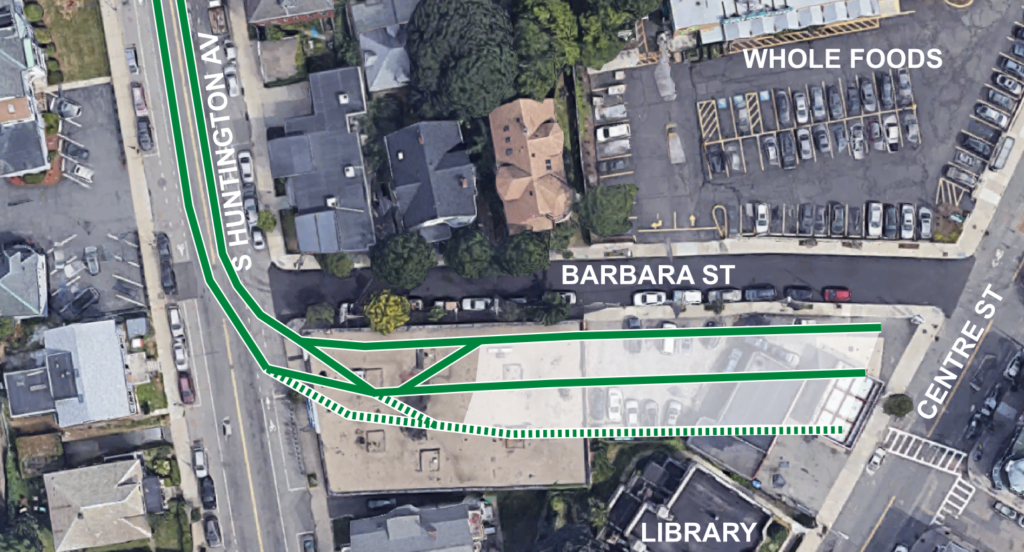
In the Hyde Square area, finding an adequate terminal proves somewhat challenging. South Huntington is not quite wide enough for a multi-track terminal to be easily built (although it would probably be possible) and the most obvious off-street possibility, the parking lots on the Angell MSPCA property, are too far north of the main ridership generators further south in JP. One possibility would be to acquire the properties on the south side of Barbara Street, the acquisition of which would likely cost in the $2-$3 million (given their current assessment, and which could be partially recouped by allow development on part of the parcel or as air rights); these are currently single-story buildings housing small businesses, which could be offered assistance in relocation. This would allow for three tracks and two island platforms for the future 200-foot trains, which is similar to the Expo Line’s Santa Monica terminus in the Los Angeles area. Given the capacity constraints on the central subway, more-frequent service necessitating a larger terminal would likely not be necessary (and two tracks may be sufficient). This terminal would be well-located adjacent to a library and supermarket.

A sketch of a terminal at Hyde Square south of Barbara St. The track shown as dashed may not be necessary.

This extension would also allow a significant recalibration of bus service in the corridor, making the overall system more efficient. The current E Branch is the only branch of the Green Line which has peak demand in the reverse direction, with the dominant flow toward the Longwood Medical Area in the morning and away from it toward downtown in the evening. The  parallel 39 bus has an opposite profile, inbound in the morning and outbound in the evening. This leads to inefficiency: there are often full 39 buses running parallel to empty E trains in one direction and empty buses passing by full E cars in the other. There are, in fact, four overlapping markets served along the Huntington Avenue-Centre Street corridor.

  • JP Center/Forest Hills to Back Bay. While this is served by the 39 bus, most residents of this portion of JP are within an easy walk of the Orange Line, which is significantly faster.
  • JP Center/Forest Hills to Longwood. This corridor not well-served by the Orange Line, but is served by the trunk of the 39 bus.
  • Hyde Square to Longwood. This short trip is currently only served by the 39 bus, but if the E line were extended, it would provide redundant service along this corridor.
  • Hyde Square to Back Bay. Hyde Square is the furthest point on the 39 bus from the Orange Line which is not also served by the Green Line. Thus, it is often faster to take the 39 bus downtown than to walk to the Orange Line, despite the congestion encountered by the 39 on South Huntington.

The Hyde Square E Line extension would allow simplification of this route structure. The 39 bus would still be required for the JP Center to Forest Hills trip. However, the two Hyde Square trips, which currently cause most of the crowding on the 39 bus, would instead be replaced by the E Line, which has plenty of room in this “reverse-peak” (as far as ridership is concerned) direction. Thus, the 39 bus could conceivably be truncated to the Longwood Medical Area, since the E Line would provide the necessary service from Hyde Square to Downtown and Back Bay (with service from JP Center to Downtown provided by the Orange Line, or by transferring). The current markets would be preserved, and the half-mile extension of the E Line would be balanced by truncating the 39 bus by three times that distance.

Stations would also be consolidated, to provide accessibility without too-close stop spacing. A single bus/rail station would take the place of Mission Park and Fenwood Road on Huntington Ave, serving the 39, 66 and E Line. The Riverway Station would remain, with the potential to build a level-boarding island for buses and trolley cars. The Back of the Hill and Heath Street stations would be consolidated up the hill and closer to the entrance to the VA. This would provide better access to the VA, the new apartments across the street, and place the station on a less-steep hill. A final station would be just south of Bynner Street (on a straight, flat area) before the terminal at Hyde Square. VA and Bynner could be designed as center platform stations for the E Line, and buses could stop in the travel lanes adjacent to them. This would minimize the need to remove parking spaces.

South Huntington, typical profile. Note that while a curb-lane buffered bike lane would be preferable, this setup allows
additional room for parked cars if the street is narrowed due to snow accumulation without fouling the trolley right-of-way.

South Huntington station profile, with Green Line in mixed-traffic and center platforms for trolleys, side stops for buses. Given the narrow width of the Green Line vehicles (104″, or 8’8″) it would be easy for cars and bicyclists to pass stopped trolleys in a shared lane. When trolleys aren’t present, cars could pass bicyclists.
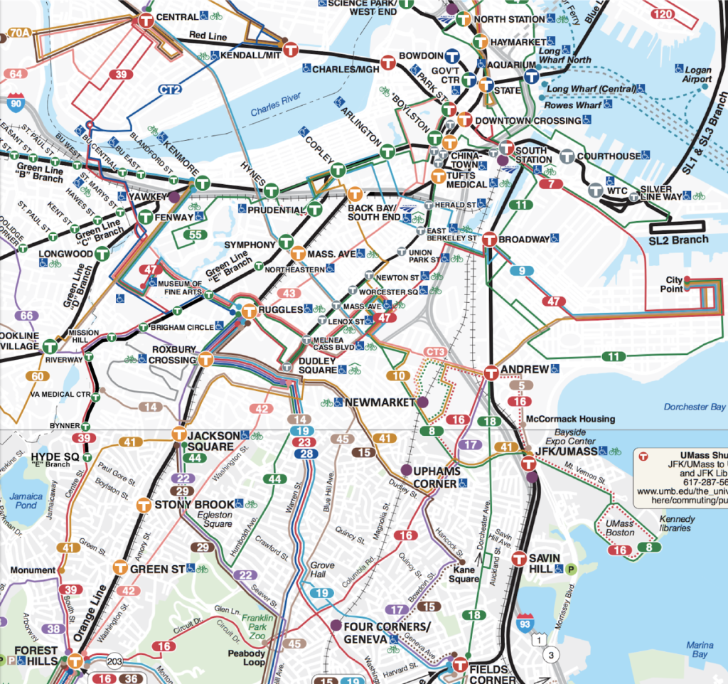
Truncating the Back Bay portion of the 39 bus would have additional benefits, since it would not necessarily have to end its route in Longwood, but could instead provide through service. One intriguing idea would be to merge the 39 and the western half of the 47 bus. The 47 is an amalgam of bus routes: the original Cambridgeport bus (one of the first streetcars converted to a bus, in the 1920s) was extended across the Cottage Farm Bridge and lengthened over time so that it now runs from Central Square to Broadway, with a running time generally in the neighborhood of an hour. Does anyone ride the entire route? Unlikely, given that the Red Line makes the same trip in under 20 minutes. So the 47 could be broken in to two more manageable sections. The northern/western portion, from Cambridge to the LMA, could be interlined with the 39, allowing a direct trip from Cambridge to Jamaica Plain, a new travel pattern to the growing Cambridge market. City of Boston data show that there are 1500 Jamaica Plain residents who work in Cambridge (7.5% of the population; only the Downtown market is larger, yet there is no direct bus from JP to Cambridge), and this would likely be a popular route, utilizing the “backhaul” portion of the 47 with lower peak demand. The eastern/southern portion of the 47, now a more manageable route, could be extended from Broadway to City Point, allowing a one-seat crosstown ride from South Boston to the LMA. 
A mock-up of an MBTA map showing the E Line to Hyde Square, the 39 Forest Hills-Central and the 47 LMA-City Point.
Between Hyde Square and Heath Street, South Huntington Avenue is wide enough to allow a streetcar, some of the original trolley poles may be salvageable and could be reused, and most importantly, there is an active power feed under the street. Constructing this extension, and the transit priority between Heath Street and Brigham Circle, would be relatively inexpensive, and serve tens of thousands of passengers daily and improve the bus network as well. The half acre of land used for the new terminal at Hyde Square would be balanced by the opportunity to develop a similarly-sized parcel at the current location of the Heath Street Loop (and which would probably allow higher-density development). 
Extending the Green Line to Hyde Square, and improving the line south of Brigham Circle, should be seriously considered by Boston and the MBTA. Such a project would likely be eligible for federal funding, as well, as part of the FTA’s core capacity program. This program provides federal funding to projects which increase the capacity of heavily-used transit infrastructure. The stipulations for eligibility are:
  • Be located in a corridor that is at or over capacity or will be in five years
  • Increase capacity by 10% 
  • “not include project elements designated to maintain a state of good repair”
The E Line to Hyde Square appears to check all of those boxes. Is the line over capacity? Have you ever been on the Green Line at rush hour? The ability to run larger 200-foot trains, which would require a new terminal on the E Line, would definitely increase capacity by 10% (in fact, there might be other portions of the Green Line which could included in a core capacity grant package). And since this would be adding new service, it wouldn’t be a state of good repair project, even if part of it was to move some of the track on Huntington and South Huntington avenues to allow more efficient service. With the added benefit of the potential for federal funding, this project becomes an even easier sell. 

Getting Transit (Mostly) Right: Minneapolis-Saint Paul edition

Minneapolis and Saint Paul do not necessarily lend themselves to being a transit paradise. The core of the region is not particularly dense, and wide roads and a mostly-built freeway system make driving too easy. The tree-lined avenues of Minneapolis and Saint Paul are mostly lined by single-family homes and duplexes with sizable yards and alleyways, meaning that population densities are far less than the three-deckers of Boston, side-by-side bungalows of Chicago and row houses of DC, so there are fewer people to provide the necessary patronage for a dense network of frequent transit lines. The factors that push people to transit that define the urban experience in a Boston, New York or DC—heavy congestion and high parking costs—are, if not completely absent, less of an issue. And without many grade-separated lines, there are few cases where transit has a distinct time advantage over rush hour traffic.

Additionally, much of the area is pockmarked by both active and abandoned industry and transportation networks, further diluting the population (while, at the same time, providing significant potential for brownfield redevelopment). Most in-city residents live within a short walk of a bus line (the suburbs, for the most part, are less dense and even more car-dependent), but frequencies are often only every 20 or 30 minutes. Since the demise of the streetcar network (most car lines ran every 10 or 12 minutes or better, and streetcar ridership peaked at 238 million per year, triple transit ridership today) and the rise of the highways in the 1950s and 1960s, driving has just been to easy to compete with transit. Even at its peak, Minneapolis had just under 10,000 people per square mile, Saint Paul only 6,000; neither reached the peak density of large rust belt cities further east. (Both cities saw their populations bottom out in 1990 and have gained about 10% since.)

Minneapolis-Saint Paul was one of the largest cities without rail transit until its first line opened in 2004—a 12 mile line for a cost, in current dollars, $905 million (including two major elevated overpasses and a mile-long tunnel under the airport, despite exceeding initial estimates it is, in retrospect, quite cheap.)—and the second corridor, linking Minneapolis and Saint Paul, came online in 2014. These two corridors have, in their own right, made Minneapolis’s “Metro” the most heavily-used rail system to have been inaugurated since 2000 (since surpassed by Seattle’s Link, which is experiencing overcrowding with its recent extension), with more than 60,000 passengers per day. But there are two new smaller-scale developments which show that the Twin Cities are more forward-thinking in providing transit, and may well entice passengers out of cars while providing transit along corridors with high potential for redevelopment.

The first is the speeding up of the Green Line (formerly the Central Corridor) between Minneapolis and Saint Paul. When it first opened, the signal system of the line was not optimized for transit: trains often waited at cross streets for vehicular traffic despite the promise of transit signal priority. While the line is not perfected in the way that the Blue Line, which has gated, at-speed grade crossings, operates (and, running in the center of a city street, it likely never will be) the kinks are being worked out, and the promise of a 39-minute downtown-to-downtown ride is coming to fruition (the downtown sections are still quite slow and trains have minimal signal priority there). Speeds have also been improved, to 40 mph between most stations and 50 where there are no cross streets for long distances. (Note that this center-running light rail line runs faster than any MBTA subway or light rail service.) Further progress may be made, but the cities have not kowtowed to a few delayed drivers, and reaped both the operational efficiencies of running trains faster, as well as the potential for higher ridership. Trains run just every ten minutes, but with three 100-foot-long railcars, they have a capacity of more than 500 passengers each.

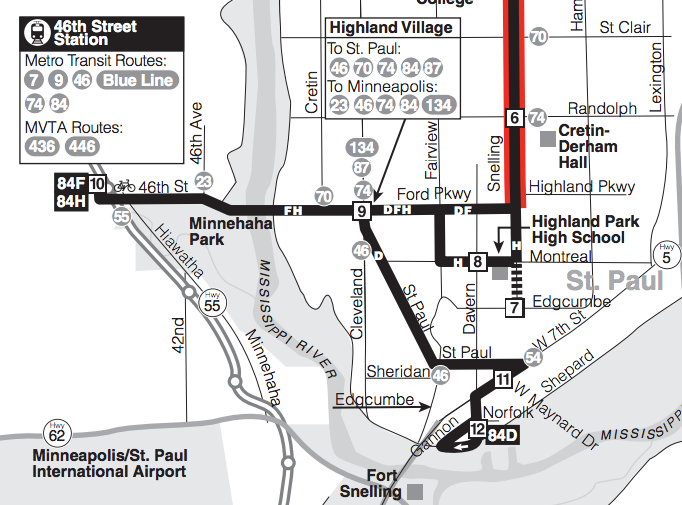
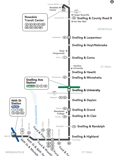
The second is the upcoming A Line bus rapid transit route in (mostly) Saint Paul. While not true BRT—there are few, if any, protected lanes, and the efficacy of transit signal priority will have to be tested—it’s the right steps towards getting more riders on to buses, and then on to trains beyond. The 84 has long been an important crosstown route running north-south between Minneapolis and Saint Paul. It connects the Green Line at Snelling Avenue with the Blue Line at 46th Street in Minneapolis, and with the rail lines has acted as a major feeder route to the two lines, albeit an urban bus route with frequent stops, often picking up just one or two passengers at each due to the density of the area, slowing down the route.

The new A Line will eliminate the Montreal joggle, a vestige
from the pre-light rail routing of the line.

Beyond this, it has had its share of issues. It has long been a frequent route—every fifteen minutes for the trunk service—but service was downgraded in 2004 when the direct trip to the airport and Mall of America was severed and required a transfer to the Blue Line. Additionally, until recently, only every other trip made the airport run, meaning service to the rail line was only available every 30 minutes, a major transfer penalty, especially changing from rail to bus. The other branch of the route dead-ended at the 54 bus, which also ran to the airport, but with less frequency (every 15 minutes) and without the passenger amenities at the transfer point. Furthermore, the line had several twists and turns. Before 2004, it made several jogs through Saint Paul en route to the airport. In the past decade, most buses serving the light rail have detoured half a mile south of the straight east-west route to the rail transfer station, providing some additional coverage but adding several minutes of extra travel time to each trip. When there are few advantages to bus travel in the first place, once a route goes out of its way in this manner, driving becomes even more logical.

No joggles! The new A Line will follow
the city street grid: the most direct route.

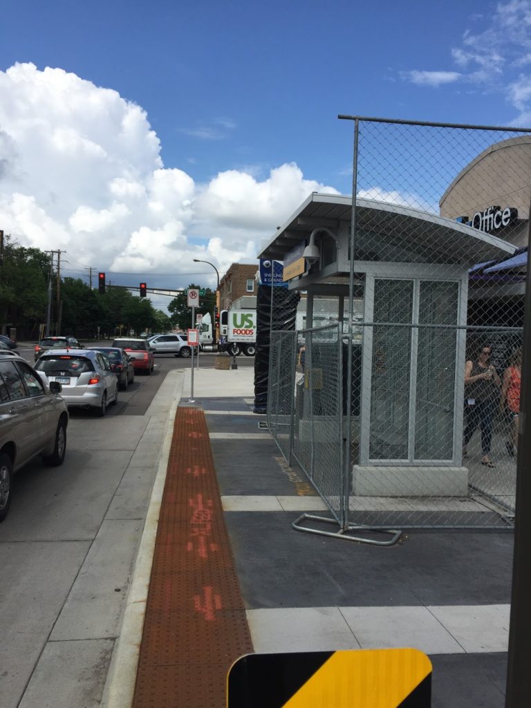
The new A Line BRT route will eliminate many of the factors which make driving more desirable in this corridor. First, stops will be consolidated, from eight or ten per mile to two or three, mostly at major nodes, bus transfers and “100% corners” which developed around these streetcar transfer points in the first half of the 20th century (the term has since been applied to highway interchanges in suburbia and transit transfer stations downtown). Each stop will be more developed, with heftier shelters with heating elements (important in Minnesota winters) and real-time departure information (important for everyone, but especially choice riders). Each station will have a fare machine and provide off-board fare collection, distinct vehicles with wider doors, and all-door, level boarding to minimize dwell times. Furthermore, buses will stop in the right travel lane, at a curb bump-out, so buses will not waste time pulling in and out of travel lanes. This will all enhance the speed of the route and the customer experience, and an analysis shows that it will bring many jobs closer to residents of the corridor.

Frequency will increase as well, with 10 minute headways matching headways of the light rail lines (frequency had been increased in 2014 to this level when the Blue Line opened, but not all buses ran to the Blue Line in Minneapolis), so transfers between the two lines will be minimal. Very importantly, these won’t just be rush-hour frequencies, but for midday service seven days per week (shoulder periods—before 6 a.m. weekdays, slightly later on weekends, and after 7:30 p.m. on weekdays and slightly later on weekends—will be somewhat less frequent, but still generally every 15 or 20 minutes). And the hodgepodge of coverage-based joggles will be eliminated: an every-half-hour 84 route will provide this coverage service, but the every-ten-minutes A Line will follow the grid to a T—or, as it happens, a backwards “L”—taking the most direct route possible. (The 84 will also provide service every block along Snelling Avenue, continuing a fallacy among many transit agencies that stops can not be consolidated at any cost. Thus some operational efficiencies will be lost by having empty buses running along the route, as nearly all passengers will opt for the faster and more frequent A Line. Even with stations every half mile along the Blue Line, MetroTransit still runs the 16 bus along the route, making these frequent stops. Based on limited observations, there are few, if any, riders, and it may behoove the agency to take whatever constituent hits are involved in putting this type of service out of its misery.)

New stations feature curb bump-outs so buses
board in regular traffic lanes.

Is it perfect? Certainly not. Buses will still be susceptible to congestion, especially in the crowded Midway area, where exclusive bus lanes may be a future improvement. But it’s a major improvement, and for (relatively) minor dollars. Rather than a showy BRT or rail system (the corridor is probably not dense enough for rail, and doesn’t have the traffic issues that would require a full-on, expensive BRT system) the new A Line seems to address the most salient issues with a cost-benefit analysis, with low-cost, high-impact solutions (what they call Arterial BRT). It can also be incremental; if it’s successful, it will give the political capital to make further improvements, which may mean taking car travel lanes or parking spaces for queue jump lanes of exclusive bus facilities. It will leverage the much-improved Green Line light rail connecting to the downtowns with a better connection from the Snelling corridor, and the Blue Line at the other end. This system did not have free-falling ridership that would require a Houston-level redesign (bus ridership has grown in recent years, even as a major corridor—University Avenue—was replaced by light rail), but certain corridors—like the 84—did need improvement (others still do). This is a model which should be used for other high-use corridors in the Twin Cities (which is planned), and other systems in the US as well.

I started riding the 84 in 2002 (it still carried a note that it had been renamed from the Saint Paul 4—until 2000 Minneapolis and Saint Paul parochially had duplicate route numbers in different cities, like boroughs in New York) as a first year student at Macalester College, frequently to and from the airport. It ran every half hour, but with direct service it made the terminal impressively close: even with the joggles in the route, it was less than a 20 minute ride, door-to-door. The actually service degraded in 2004 with the rail transfer: it usually took about 30 or even 35 minutes, especially with the extra trip down to Montreal Avenue, and still only every half hour.

It took ten years, but a sensible route has finally been worked out. While the new service won’t match the speed of the pre-2004 service, with a more direct route, fewer stops and 10 minute headways for both the bus and the light rail, the trip, even with a transfer, should take about 25 minutes (with a perfect transfer at non-peak times, it may actually beat the circa-2004 20-minute mark), with the bus running up to 25% faster. Considering it will come three times as often, it will (finally) take full advantage of the light rail, and provide better service to the Snelling corridor in Saint Paul. Hopefully residents will notice the improvements and avail themselves of better transit options, even if it’s never perfectly competitive with an automobile.

Update: so far people are mostly happy with it, with one curmudgeon who won’t walk the extra block to a stop in the winter, supposedly. Update 2: Ridership on the corridor is up 25%.

Saving GLX by (temporarily) cutting Fitchburg?

The Commonwealth of Massachusetts is mostly finished with a $300 million rehabilitation of the Fitchburg Line, which will yield more capacity on the line and faster speeds on the longest in-state line in the system. At the same time, the Green Line extension project has seen exponential growth in cost, mostly due to bizarre contracting methods and poor oversight. But it’s still a complex project. And now an idea is being floated to cut back a branch of the line to Union Square in Somerville—a branch which parallels the Fitchburg Line—which is in dire need of better transit.

But maybe this presents an opportunity for some out-of-the-box thinking. Both branches of the GLX are slated to be built alongside existing Commuter Rail lines, and building next to an active railroad is not particularly easy. There are safety concerns, FRA issues, and even the cost of staff to insure the safety of workers—and the safe passage of trains—comes at a significant cost. If you could cut all parallel rail service, you could save a lot of time and money: rather than having to rebuild in a constrained corridor, you could more quickly build the project in a much easier work environment.

This, of course, would require cutting Commuter Rail off from the the terminal in Boston. For Lowell, this is a non-starter: busing from Winchester or West Medford would be subject to the whims of traffic on I-93, as would buses from Anderson/Woburn. And the Lowell Line also serves Amtrak and some Haverhill trains which bypass traffic on the single-tracked portions of the Haverhill Line. At busy times on this line, there is a train every ten minutes.

But for Fitchburg, this presents an opportunity. Before getting to Boston, Fitchburg Line trains stop at Porter Square. Already, between 30 and 50% of Fitchburg riders begin or end their Commuter Rail trip at Porter, transferring for a trip to Harvard, Kendall or even in to Boston. What if, for a short period of time, you closed the line inbound from Porter to allow for reconstruction, and had everyone transfer at Porter?

While this would be inconvenient for some riders, and put a bit more of a load on the Red Line, it might save a lot of time, and a lot of money, in the construction of the Union Square portion of the Green Line extension, as well as the portion near Lechmere where the branches meet and cross over the Fitchburg Line. Shuttle bus service could be provided between North Station and Porter (a 20 minute ride) but most passengers would take the Red Line. Considering that nearly half the riders already get off, and most jobs downtown are located near or south of the Red Line (in the Financial District and Back Bay) this would be only a minor inconvenience for them. With faster track speeds on the Fitchburg Line, in fact, it might actually be a wash for many commuters.

Using GTFS, I’ve tested out a few test trips from South Acton:

+16 minutes to North Station
42 minutes via North Station
58 minutes via Porter, Red Line and Green Line.

+6 minutes to Seaport
66 minutes via North Station and #4 bus
72 minutes via Porter, Red Line and Silver Line

+5 minutes to Copley
56 minutes via North Station and Green Line
61 minutes via Porter, Red Line and Green Line

+3 minutes to Park Street
52 minutes via North Station and Green Line
55 minutes via Porter and Red Line

0 minutes to LMA
72 minutes via North Station and Green Line
72 minutes via Porter, Red Line and #47 bus

0 minutes to South Station, Kendall and Harvard
58, 48 and 42 minutes via Porter already faster than via North Station

It’s a wash for most commuters other than those traveling to North Station, and most commuters’ final destination is not at North Station, but somewhere to the south (since North Station is mostly surrounded by highway ramps and water). In the long run, running trains to North Station makes sense. But if service could be curtailed at Porter for a year to save millions of dollars, I think it is a worthy sacrifice.

In addition, service on the Fitchburg Line could increase in frequency. Each train terminating at Porter would save 20 minutes of round trip running time. This could be translated in to an extra trip in each rush hour to help spread the load, and an extra midday and evening trip as well using the same equipment. It would also be a good opportunity to, once and for all, construct high-level boarding platforms at Porter to allow faster boarding of trains at the station. The two-track station would be more than adequate for the current schedule on the Fitchburg Line, and during the midday, trains could be stored on the tracks beyond the station well shy of construction in Union Square.

The five train sets currently stored in Fitchburg would be enough for full service on the line; the first train arrives in Porter at 6:40 and could easily make the outbound run to Littleton for the 8:20 service back to Boston in the morning. In the evening, the first outbound train to Littleton could easily turn back to Boston in time for the late local departure at 6:20 (which could be pushed back a few minutes with no ill effect on passengers).

With the route mostly cut off from the network, light maintenance would have to be established somewhere along the line (perhaps at the maintenance of way facility near Alewife). For heavier maintenance, trains would have to be shuttled to Lowell across the Stony Brook line from the Willows. This railroad is slow and would need improvement for anything but occasional moves (if it were faster, it could host passenger service from Fitchburg to Boston via Lowell) but would likely be adequate for short-term moves. The extra crew costs would be offset by the savings of rebuilding the inner part of the line quickly and economically.

Is there precedence for this? There is. From 1979 to 1987, the Southwest Corridor was rebuilt below grade between Hyde Park and Back Bay for the relocated Orange Line. The issue was that the Needham Line was only accessible via the corridor. Rather than keeping a track in service and continually moving it around for the rest of the rebuild, they shut down Needham service, replaced it with express buses (which encountered less traffic on the Turnpike than they would today) and rebuilt the corridor in place, That project is obviously larger than the Fitchburg project, and necessitated a longer shutdown, but there are certainly similarities which could yield similar cost savings. See page 202 here.

Something is very wrong with MBTA project procurement

When the news broke about the escalating costs of the MBTA’s Green Line extension to Medford and Somerville, I can’t say I was surprised, but the cost numbers have now escalated in to absurdity. I’m not an expert in the bizarre project procurement, but the costs are now to the point where the project really should be reviewed and rebid, even if there is a delay. It is far beyond what similar projects cost in other cities, and the project procurement team at the T should be removed to allow someone from the outside to bid the project.

How ridiculous are the T’s numbers? Let’s take a look at them, and compare them with some other projects:

Minneapolis-Saint Paul Green Line
Distance: 11 miles
Cost: $957 million
Cost per mile: $87 million
Completion date: 2014
Engineering difficulties: rebuilding bridge over Mississippi River for light rail, rebuilding the entirety of University Ave lot line-to-lot line, junction and flyover with existing Blue Line in Minneapolis. Likely cheaper than the Green Line extension. But not 9 times cheaper.

Los Angeles Expo Line Phase II
Distance: 6.6 miles
Cost: $1.5 billion
Cost per mile: $227 million
Completion date: 2016
Engineering difficulties: Several grade separations, parallel bike/walk facility. Still four times cheaper than the GLX.

San Francisco Central Subway
Distance: 1.7 miles
Cost: $1.6 billion
Cost per mile: $941 million
Completion date: 2019
Engineering difficulties: full deep bore tunnel in a seismically active area with three underground stations. In a rather expensive city to work in. And barely more than the GLX, which is being constructed in a grade-separated right of way!

Seattle University Link
Distance: 3.1 miles
Cost: $1.9 billion
Cost per mile: $613 million
Completion date: 2016
Engineering difficulties: full deep bore tunnel below the water table in a seismically active area with two underground stations. And quite a bit cheaper per mile than GLX.

Now, here are two MBTA projects:

Red-Blue Connector
Distance: 1300 feet
Cost: $750 million
Cost per mile: $3 billion
Completion date: ???
Engineering difficulties: Cut and cover tunneling below the water table in a constrained corridor. Certainly no greater than building the Central Subway in San Francisco, yet somehow three times more expensive. This should probably be in the lower end of the $100 to $200 million range, not three quarters of a billion.

Green Line Extension
Distance: 4.3 miles
Cost: $3 billion
Cost per mile $700 million
Completion date: 2019?
Engineering difficulties: Relocating existing parallel commuter rail line, building a flying junction, parallel bike/walk facility.

Here’s the thing: none of the engineering challenges faced by the GLX and RBC are unique (flying junction in Minneapolis, parallel path in LA) or insurmountable, yet the costs are an order of magnitude greater than in other cities. The Green Line Extension is between three and nine (!) times more expensive than similar light rail lines, and more expensive than new light rail lines which are being built using deep bore tunneling techniques, which are not cheap. High construction costs? Seattle and San Francisco have pretty high construction costs and labor wages too. The remaining GLX construction should be rebid mimicking the processes used in these cities with a new team at MassDOT, and if costs aren’t cleaved significantly, there should be a full investigation as to why.

The for the Red-Blue connector, which everyone agrees is a very important link, somehow costs three to four times what much more complex projects cost in Seattle and Los Angeles (while the Blue Line uses heavy rail equipment, it is the same diameter as light rail trains). The project is only 1500 feet long, doesn’t require a deep bored tunnel, and has only one station at Charles, and the headhouse there already exists with provisions to connect it to the Blue Line. The fact that it costs $2.6 billion dollars per mile is laughable. For the cost of one mile of construction in Boston, Minneapolis could build 30 (!) miles of light rail, and Seattle four miles of deep bore tunnel (about what you’d need for the North South Rail Link) and at a cheaper rate per mile than the Green Line Extension. It’s not even in the ballpark of reality, and whoever at MassDOT comes up with these numbers needs to be sent out to pasture.

There is no logical reason why a project in Boston should cost triple—or more—what a similar project costs in another city. $2 billion was suspiciously high. $3 billion means that a lot of people are on the take, or that money is being pissed away. I’m all for transit expansion, but not at these prices. An outside manager is a good start. But this has been a problem for a long time, and the T’s project procurement staff has shown no ability to do their jobs. Get rid of them.

This is correctable. It needs to be corrected.

Ugh … the Silver Line

Originally posted as a comment on The Transport Politic. I’m sure I’ll write about the Silver Line again.

The Silver Line has so many problems.

First off, there’s this bizarre notion that people from Roxbury and Mattapan need to get to the airport. All the time, forever. It’s probably not the case. I’m not one to make brash generalizations, but here’s one: the people who generally use the airport are folks from affluent and/or student-infested parts of Boston. At higher rates, anyway, than the Roxbury-Mattapan. For this community, access to downtown Boston and better-than-bus service is probably paramount. It would make much more sense to take this $114m and build a spur of the blue line in to the actual airport. Build a loop to the terminals. Heck, build it in to Central Parking, where there are elevated walkways to all the terminals. Eliminate the shuttle bus (which I once tried to take before a long weekend and it was packed to the gills with college students with dozens more waiting to board).


View Logan Blue Line Spur in a larger map

Second, the Silver Line from South Station to the airport is very slow. The tunnel is fast enough—the speed is slow but it’s grade separated, so it works. The problems arise once the buses reach the surface. The then cross D Street and proceed to drop the trolley poles and switch to petroleum. The route then takes a convoluted backtrack loop back towards South Station, across D Street, through several lights, before the bus can finally turn down in to the tunnel. $15b and they couldn’t build a ramp straight to the airport, which would have been rapid.

Then, the airport. Since Boston is the furthest northeast city in the country, Logan has never developed in to a hub airport. Thus, no one has ever built one big terminal. So the airport is a hodgepodge of terminals, each with an access road which gets choked with traffic. Sure, the buses can sometimes bypass these queues, but they still have to go through the loops in to terminals A, B, C, and E (with two stops in B—Terminal D doesn’t really exist). Ten of fifteen minutes later, they loop back in to the tunnel and a mess of roads before looping back to South Station.

I’m very glad that “Phase III” has been all but nixed by the Feds. A $1.4b tunnel would not fix the main issue that trips are scheduled to take 38 minutes to go from South Station to the airport and back. As the crow flies, this is just over a mile. A Blue Line spur to the airport, with stops at Maverick and Aquarium, would tie in to the rest of the system with trip times of maybe eight minutes, tops, with faster loading and more capacity, to boot.

*****

But that’s really actually not the worst part. Again, I’ll start by explaining that I am happy that the $1.4b tunnel from pretty much nowhere to pretty much nowhere with a couple sharp curves thrown in was not funded. From Boylston Station on the Green Line five blocks south is a disused tunnel for streetcars, and the plan was to basically decimate that tunnel to build it to bus loading gauge. Here’s the thing—the tunnel ties in to the Green Line—to a four track alignment to Park Street Station—and is grade separated, underground!, at the junction. Basically, if you turn back one line of the green line at Park Street, you could add in another without increasing capacity on the congested central subway.

And this tunnel would tie in splendidly with light rail down towards Mattipan. You build a new portal at Tremont and Oak and cut diagonally across the Turnpike and NEC from Shawmut to Washington. Washington Street is wide enough for trolley cars to not interfere with parked cars by occupying the center lanes. (Washington Street once had the elevated above it.) Stations in the center of the tracks, proof of payment ticketing perhaps, and you don’t impede traffic significantly, which could pass stopped trains.

Getting through Roxbury might be fun—but you could use the old elevated right-of-way for one or both tracks of a light rail line. Or tunnel underneath if you had the dollars. From there, Warren Street has two lanes each way plus a wide median, so congestion wouldn’t be a major issue) to Quincy Street, where you’d then have to build on a two-lanes-plus parking street to Blue Hill Avenue for less than half a mile. Cut parking to one side of the street and build wide lanes and you’d be fine.

Then you hit Blue Hill Avenue. The Avenue is three lanes each way plus a wide median all the way down to Mattapan, where you could connect with the High Speed Line. Trolley tracks could be in a separate median (like Comm Av or Beacon Street in Brighton and Brookline). In fact, this was the case in the past.


View Boylston-Roxbury-Mattapan in a larger map

For a heck of a lot less than 1.4b. (Portland can build a streetcar for $25m/mile. This is 7.5 miles. Make that $30, throw in $50 for a new portal at Tremont and $25m for a bridge across the Pike, and the cost is $300m.