Let’s talk about safe streets in Cambridge

I’m tired of going to public meetings. Especially meetings organized by businesses in Cambridge where they accuse bicycle advocates of top-down planning which is making the roads unsafe, open the meeting by saying they don’t care about data (“then why are we here?”) and close by saying the want to collect anecdotes. They go on to complain that there has been no public process (which is interesting, given I’ve been part of a lot of this process) and say that the facilities are unsafe because they think they look unsafe. Let’s look at some of their “arguments” and break them down, and then let’s give the public some talking points for pushing back at subsequent meetings.

1. Don’t let “them” set the meeting agenda. If a meeting is billed as a “community” meeting, it should be led by the community. If the businesses are taking charge, before the start the meeting, go up to the dais and propose the following: that the meeting be led by a combination of the community members and the business association. Have a volunteer ready to go. If they refuse, propose a vote: let the people in attendance vote on the moderator. If they still refuse, walk out. (This obviously doesn’t go for city-led meetings, but for these sham public meetings put on by the business community which are only attended by cyclists if we catch it.)

2. Ask them about business decline data. I don’t believe they have it. They claim that business is down because of the bike lanes, but ask by how much, and how many businesses. There is very likely a response bias here. Which businesses are going to complain to the business community about sales being down? The ones with sales which have gone down. Better yet, come armed with data, or at least anecdotes. Go and ask some businesses if their sales have been harmed by the bike lanes. Find ones which have not. Cite those.


3. There has been plenty of public process. The anti-bike people claim that there has been no public process, and that the bike lanes have been a “top-down” process. These arguments are disingenuous, at best. The Cambridge Bicycle Plan was the subject of dozens of meetings and thousands of comments. If residents and businesses didn’t know it was occurring, they weren’t paying attention. It would also do them some good to come to the monthly Bicycle Advisory Committee meetings, where much of this is discussed (they’re open to the public; and committee members take a training on public meeting law to make sure procedures are carried out correctly). These are monthly, advertised meetings. If you don’t show up, don’t complain about the outcome.

Then there’s participatory budgeting. The bike lanes on Cambridge and Brattle streets rose directly from participatory budgeting. This was proposed by a citizen, promoted by citizens, vetted by a citizen committee and voted on by citizens. Yet because the Harvard Square Business Association didn’t get a voice (or a veto), it was “top down.” They’d propose a process where they dictate the process, which is somehow “grassroots.” This is untrue. Don’t let them get away with this nonsense. The bike lanes are there because of grassroots community activism. If they don’t like them, they had their chance to vote. They lost.

4. Bike lanes cause accidents. After the meeting, a concerned citizen (a.k.a. Skendarian plant) took me aside to tell me a story about how the bike lanes caused an accident. I didn’t know what to expect, but they told me that the heard from Skendarian that a person parked their car and opened their door and a passing car hit the door. I was dumbfounded. I asked how the bike lane caused the accident and was told the bike lane made the road too narrow. He liked the old bike lanes, so he could open his door in to the bike lane. So if you hear this story, remember, this was caused by a car hitting a car. And if someone says that bike lanes require them to jaywalk to reach the sidewalk, remind them that 720 CMR 9.09(4)(e) says that a person exiting a car should move to the nearest curb, so crossing the bike lane would be allowable.

5. Data. The anti-bike forces will claim they don’t want to use data. There’s a reason: the data do not work in their favor. They may claim that the data don’t exist. This is wrong. The Cambridge Police Department has more than six years of crash data available for download, coded by location and causation; the Bicycle Master Plan has analyzed his to find the most dangerous locations. Who causes crashes? More than 99 times out of 100: cars. (Note: object 1 is generally the object assumed to be at fault.)

When I dowloaded these data last year, there were 9178 crashes in the database. If someone mentions how dangerous bicyclists hitting pedestrians is, note that in six years, there have been five instances where a cyclist caused a crash with a pedestrian. (This shows up as 0.1% here, it’s rounded up from 0.05%. Should this number be less? Certainly. But let’s focus on the problem.). There have been 100 times as many vehicles driving in to fixed objects as there have been cyclists hitting pedestrians. Maybe we should ban sign posts and telephone poles.

I’ve written before about rhetoric, and it’s important to think before you speak at these sorts of meetings (and, no, I’m not great about this). Stay calm. State your points. No ad hominem (unless someone is really asking for it, i.e. if you’re going after the person who says they don’t care about bicycle deaths, yeah, mention that). Also, don’t clap. Don’t boo. Be quiet and respectful, and respect that other people may have opinions, however wrong they may be. When it comes your turn, state who you are and where you live, but not how long you have or haven’t lived there. When they go low, go high. We’re winning. We can afford to.

Cambridge Council Endorsements

I know you’ve all been waiting for it … the Official Amateur Planner 2017 Cambridge City Council endorsements!

I’ve lived in Cambridge for 6 years now, served on the Bicycle Committee for most of that time and gone to more council and zoning meetings than I care to admit. I’m making these endorsements based on two criteria: bicycle safety and progressive development policy (with a bit of transit thrown in). A bit of background:

1. Bicycle safety has become a hot button issue in Cambridge in recent years as more and more people have embraced cycling to work, and our infrastructure hasn’t kept up. There is some talk that the recent activism, especially among younger voters, will change the makeup of the electorate in Cambridge this year. Nominally, all candidates are for safe cycling, but in reality, some are more than happy to sell out to the interest of the minority of people driving in Cambridge. After several “pop-up” lanes were installed this spring, there was a bit of “bikelash” in Cambridge, with some City Councilors calling for a moratorium until we could figure out how to make bike lanes not impact—well, something. They’re not sure. Let’s call it “easy parking and the free flow of traffic.” Most insidious: the Harvard Square Business Association trying to kill bike lanes because cars. Councilors Simmons, Toomey and Maher supported this. they’re off the list. (They also got their comeuppance: hundreds of cyclists, three hours of public comment and a meeting that ran until after midnight; I doubt they’ll be pulling this sort of stunt any time soon.) Craig Kelley, based on several interactions, is kind of wishy-washy on safe cycling infrastructure, and while he often touts himself as a cyclist, he often veers in to the vehicular cycling realm. Sorry, Craig. For others, and for new candidates, I’ll defer to the Cambridge Bicycle Safety group’s list.

2. Development. Here, most candidates fall in to two camps, the Cambridge Residents Alliance and A Better Cambridge. Both are nominally aligned with allowing more development, but only one—A Better Cambridge—actually follows through. There are a few arguments against additional density and development, none of which hold water:

  • Gentrification. In Cambridge, this has already happened. So new luxury housing is not going to “improve” neighborhoods and increase existing rents, despite what CRA may say. This is, in general, grade-A horse manure.
  • Road/transit congestion. This too is a red herring. Cambridge itself is not that congested, most people bike, walk and take transit to work. It’s the getting to Cambridge part. More local housing will mean more bike/walk/transit commutes, and the answer is not to build less housing, but to improve connections to Cambridge. Yet the CRA won’t take a position on reducing parking minimums.
  • Open space. There is an argument for keeping some Open Space. But for an organization like CRA, open space becomes “parking lots.” This needs no further explanation. (Apparently they have softened it to “it can be redeveloped for affordable housing”—good idea—”but only if the parking is replaced.” Just, no.
There have been recent pushes by small groups of residents to downzone parts of Cambridge (I’m not sure if the CRA took a position on this, but they claim that Cambridge faces “over-development“; however, I know ABC opposed it wholeheartedly.) I don’t like going to these meetings and don’t want to have to go to more! Let’s get councilors who we know won’t buy in to this nonsense. 
A local zoning case in point: There used to be an autobody shop and a couple of businesses in a decaying, single-story building at 78 Pearl Street. These were non-conforming uses, built before the area was zoned C. The land was bought and the businesses relocated. It would have been a perfect opportunity to build a mixed-use, multifamily dwelling with apartments sized appropriately for the area. However, because of the zoning, mixed-use was out (even though it was replacing businesses!) and in place of the building went 78 and 80 Pearl: 4 bedroom, 3.5 bathroom (as a friend said: “oh, so everyone can poop in their own toilet!”) single-family houses (on tiny lots) for $1.75 to $2 million. Two units instead of six. There are plenty of examples of non-conforming uses which could never be built today but fit in fine with the neighborhood. But given the land values, and the zoning, developers are forced to build this type of low-density, pseudo-suburban housing which is completely unaffordable.

So, while some CRA-endorsed candidates are beyond excellent on bicycle infrastructure (Jan Devereaux in particular, but she’s past president of the very NIMBY Fresh Pond Residents Alliance, so there’s that), this page can not endorse anyone who is endorsed by the CRA. If you’re voting just based on bikes, she should be on your list.

There is some “whataboutism” going on with some anti-development types who say that the fault lies in other cities and towns not doing their part. This is true, but it’s no reason for Cambridge not to develop more housing as well. Remember when Homer Simpson ran a campaign for garbage commissioner with the slogan “can’t someone else do it?” Can’t someone else do it is not a logical policy. Yes, there would be less pressure on local housing prices if the Newtons of the world did their part. But it’s no reason for Cambridge to keep density down.  

Oh, then there’s Tim Toomey. He’s already out for a number of reasons (when he was a Councilor and State Rep, he was making more money than the governor, so don’t feel bad if he loses his job, his pension should be just fine), but please leave him off your ballot entirely. He quashed the idea of running commuter rail to Cambridge because he was afraid of big, bad trains running on train tracks, so instead everyone from the Metrowest/Turnpike corridor drives. More congestion! More pollution! Progress! Thanks, Tim.
So with these criteria in mind, here are the official Amateur Planner-endorsed candidates. It’s easy to remember: they all begin with “M”:

  • Alanna Mallon: I met Alanna when she was canvassing. She gets it. I think she didn’t get the Bike Safety endorsement because she holds back a bit on implementation of bike lanes. But from my conversation, she is very much in favor of transit and bike lanes, and will be an ally on the Council.
  • Marc McGovern: Marc has been on the Council since I’ve lived in Cambridge, and has been on the right side of the debate the whole time. I look forward to him serving another term.
  • Adriane Musgrave: I may have talked to Adriane longer than I talked to Alanna! (Note to candidates: knocking on my door helps.) She also very much “gets it” and is super data-driven and wonky. That’s my kind of candidate!
So there you have it. If these three candidates are on the City Council, the future is bright. I will be ranking them #1, 2 and 3. (I’m not giving away my order.) If you live in Cambridge, vote how you wish. But I would urge you to vote for these candidates.

(I don’t live in Boston, but here’s my at-large council endorsement for Michelle Wu, of course. )

Thinking Big? Let’s Think “Realistic” First

The MBTA’s Fiscal and Management Control Board, according to their slides, wants to “think big.”

Thinking big is a laudable goal. The only problem is that big thinking requires feasibility, and it is a waste of everyone’s time and energy if the big thinking is completely outside the realm of what can reasonably occur or be built.

Case in point: combining Park Street and Downtown Crossing into one “superstation.” The first reason this won’t happen is that it doesn’t need to happen: with the concourse above the Red Line between the two stations, they are already one complex. (#Protip: it’s faster to transfer between the Red Line at Park and the Winter Street platform on the Orange Line—trains towards Forest Hills for the less anachronistic among us—by walking swiftly down the concourse rather than getting on the train at Downtown Crossing.) But there are several other reasons why this is just not possible.

Tangent track

To build a new station between Park Street and Downtown Crossing would require tangent, or straight, track. If you stand at Park, however, you can’t see Downtown Crossing, because the tracks, which are separated for the center platform at Park, curve back together for the side platforms at Downtown Crossing. This curve is likely too severe to provide level boarding, so the track would have to be realigned through this segment. So even if it were  easy to build a new complex here, the tracks would have to somehow be rebuilt without disrupting normal service. That’s not easy.

Winter Street is narrow. Really narrow.

The next, and related, point: Winter Street is very narrow: only about 35 feet between buildings. Park Street Station is located under the Common, and the Red Line station at Downtown Crossing is located under a much wider portion of Summer Street: those locations have room for platforms. Winter Street does not. Two Red Line tracks require about 24 feet of real estate: this would leave 5.5 feet for platforms on either side before accounting for any vertical circulation, utilities and the like. Any more than that and you’re digging underneath the century-old buildings which give the area its character. That’s not about to happen. And Winter Street would be the only logical location for the station; otherwise it would force long walks for transferring passengers.

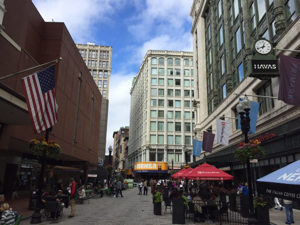
Summer Street (foreground) is wide.
Winter Street (background) is narrow.
The fact that so many streets change names crossing Washington?
Well, that’s just confusing.

Note the photograph to the right. The current Downtown Crossing station is located between Jordan Marsh on the left and Filene’s on the right (for newer arrivals: the Macy’s and the Millenium building), where Summer Street is about 60 feet wide, enough for two tracks and platforms, and it’s still constrained, with entrances in the Filene’s and Jordan Marsh buildings. Note in the background how much narrower Winter Street is. This isn’t an optical illusion: it’s only half as wide. The only feasible location for such a superstation would be between the Orange and Green lines, but the street there is far too narrow.

Passenger operations

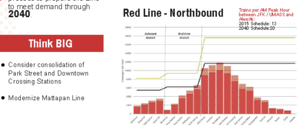
The idea behind combining Downtown Crossing and Park Street is that it would simplify signaling and allow better throughput on the line operationally. But any savings from operations would likely be eaten by increased dwell times at these stations. At most stations, the T operations are abysmal regarding dwell times; Chicago L trains, for example, rarely spend as much time in stations as MBTA trains do, as the operator will engage the door close button as soon as the doors open. At Park and Downtown Crossing, however, this is not the case. Long dwell times there occur because of the crowding: at each station, hundreds of passengers have to exit the train, often onto a platform with as many waiting to board. This is rather unique to the T, and the Red Line in particular, which, between South Station and Kendall, is at capacity in both directions. Trying to unload and then load nearly an entire train worth of passengers at one station, even with more wider doors on new cars, just doesn’t make sense.

If Park and Downtown Crossing were little-used stations, it would make no sense to have two platforms 500 feet apart, and combining them, or just closing one, would be sensible. (Unlike New York and Chicago, the Boston Elevated Railway never built stations so close that consolidation was necessary.) But they are two of the busiest stations in the MBTA system, both for boardings and for transfers. Given the geometry of the area, both above and below ground, calling this a big idea is risible. Big ideas have to, at least, be somewhere in the realm of reality. Without a 1960s-style wholesale demolition of half of Downtown Boston, this is a distraction. The FMCB has a lot to do: they should not spend time chasing unicorns.

Better Headways? Geometry gets in the way, not just signals.

In addition to a spending time on infeasible ideas like combining Park and Downtown Crossing, the FMCB and T operations claims that it would only take a minor signal upgrade (well, okay, any signal upgrade wouldn’t be minor) to allow three minute headways on the Red Line. Right now, trains come every 4 to 4.5 minutes at rush hour (8 to 9 minutes each from Braintree and Ashmont); so this would be a 50% increase. Three minute headways are certainly a good idea, but the Red Line especially has several bottlenecks which would have to be significantly upgraded before headways can progress much below their current levels. New signals would certainly help operations, but they are not the current rate limiting factor for throughput on the line.

There are four site-specific major bottlenecks on the line beyond signaling: the interlocking north of JFK-UMass (a.k.a. Malfunction Junction), the Park-Downtown Crossing complex, the Harvard curve, and the Alewife terminal. (In addition, the line’s profile, which has a bi-directional peak along its busiest portion, results in long dwell times at many stations.) Each of these is it’s own flavor of bottleneck, and it may be informative to look at them as examples of how retrofitting a century-old railroad is easier said than done. This is not to say that a new signaling system shouldn’t be installed: it absolutely should! It just won’t allow for three minute headways without several other projects as well. From south to north:

JFK-UMass

This is likely the easiest of the bottlenecks to fix: it’s simply an interlocking which needs to be replaced. While the moniker Malfunction Junction may not be entirely deserved (the Red Line manages to break down for many other reasons), it is an inefficient network of special track work which dates to the early 1970s and could certainly use an upgrade. In fact, it probably would be replaced, or significantly improved, with the installation of a new signal system.

Park/Downtown

Right now, Park and Downtown Crossing cause delays because of both signaling and passenger loads. For instance, a train exchanging passengers at Downtown Crossing causes restricted signals back to Charles, so that it is not possible for trains to load and unload passengers simultaneously at Park and Downtown Crossing. Given the passenger loads at these stations and long dwell times at busy times of day, it takes three or four minutes for a train to traverse the segment between the tunnel portal at Charles and the departure from Downtown Crossing, which is the current rate-limiting factor for the line. If you ever watch trains on the Longfellow from above (and my new office allows for that, so, yeah, I’m real productive at work), you can watch the signal system in action: trains are frequently bogged down on the bridge by signals at Park.

A new signal system with shorter blocks or, more likely, moving blocks would solve some of this problem. A good moving block system would have to allow three trains to simultaneously stop at Park, Downtown Crossing and South Station. So this would be solved, right? Well, not exactly. Dwell times are still long at all three of these stations: as they are among the most heavily-used in the system. Delivering reliable three-minute headways would help with capacity, but longer headways would lead to cascading delays if trains were overcrowded. There’s not much margin for error when trains are this close together. Given the narrow, crowded stairs and platforms at Park and Downtown crossing, the limiting factor here is probably passenger flow: it might be hard to clear everyone from the platforms in the time between dwells. And it is not cheap to try to widen platforms and egress. A new signaling system would help, but this still may be a factor in delivering three minute headways.

The Harvard Curve and dwell times

Moving north, the situation doesn’t get any easier to remedy. When the Red Line was extended past Harvard, the President and Fellows of Harvard College would not allow the T to tunnel under the Yard, so the T was forced to stay in the alignment of Mass Ave. This required the curve just south of the station, which is limited (and will always be limited) to 10 miles per hour. The curve itself is about 400 feet long, but if any portion of the train (also about 400 feet long) is in the curve, it is required to remain at this restricted speed. So the train has to operate for 800 feet at 10 mph, which takes about 55 seconds to operate this segment alone. Given that with Harvard’s crowds, it has longer dwell times due to passenger flow, traversing the 800 feet of track within the station and tunnel beyond takes more than two minutes under the best of circumstances.

Would signaling help? Maybe somewhat, but not much. Even a moving block signal system would not likely allow a train to occupy the Harvard Platform with another train still in the curve. Chicago has 25 mph curves on the Blue Line approaching Clark/Lake and operates three minute headways, but they also frequently bypass signals to pull trains within feet of each other to stage them, something the T would likely be reticent to do. It may be possible to operate these headways but with basically zero margin for error. Any delay, even small issues beyond the control of the agency, would quickly cascade, eating up any gains made from running trains more frequently. This is a question of geometry more than anything else: if trains could arrive and leave Harvard at speed, it wouldn’t be an issue. But combining the dwell time and the curve, nearly the entire headway is used up just getting through the station.

Alewife

The three issues above? They pale in comparison to Alewife. Why? Because Alewife was never designed to be a terminal station. (Thanks, Arlington.) The original plan was to extend the Red Line to 128, with a later plan to bring it to Arlington Heights. But these plans were opposed by the good people of Arlington, and the terminal wound up at Alewife. The issues is that the crossover, which allows trains to switch tracks at the end of the line, didn’t. It wound up north of Russell Field, along a short portion of tangent track between the Fitchburg Cutoff right-of-way and the Alewife station, and about 900 feet from the end of the platform. If a train uses the northbound platform, it can run in to the station at track speed (25 mph, taking 50 seconds), unload and load at the platform, and allow operators to change ends (with drop back crews, this can take 60 seconds), and then pull out 900 feet (25 mph, taking 30 seconds) and run through the crossover at 10 mph (45 seconds). That cycle takes 185 seconds, or just about three minutes, of which about a minute is spent traversing the extra distance in and out of the station. If the train is crossing over from one track to the other would foul the interlocking, causing approaching trains to back up. And since this is at the end of the line, there’s significant variability to headways coming in to the station, so trains are frequently delayed between Alewife and Davis waiting for tracks to clear.

Without going in to too much detail, the MBTA currently has a minimum target of about 4 minute headways coming out of Alewife. Without rebuilding the interlocking—and there’s nowhere to do this, because it’s the only tangent portion of track, and interlockings basically have to be built on tangent track—there’s no way to get to three minute headways. In addition, the T is in the enviable position of having strong bidirectional ridership on the Red Line. In many cities, ridership is unbalanced: Chicago, for example, runs three minute headways on their Red Line from Howard at peak, but six minutes in the opposite direction from 95th (this results in a lot of “deadheading” where operators are paid to ride back on trains to get back to where they came from). The T needs as many trains as it can run in both directions, so it has to turn everything at Alewife (never mind the fact that there’s no yard beyond; we’ll get to that). This also means that T has to run better-than-5-minute headways until 10 a.m. and 8 p.m. to accommodate both directions of ridership. While this means short wait times for customers, it incurs extra operational costs, since these trains provide more service than capacity likely requires and, for instance, we don’t need a train leaving Alewife every four minutes at 9:30, except we have to put the trains somewhere back south.

In the long run, to add service, Alewife is probably unworkable. But there is a solution, I think. The tail tracks extend out under Route 2 and to Thorndike Field in Arlington. The field itself is almost exactly the size of Codman Yard in Dorchester. Assuming there aren’t any major utilities, the field could be dug up, an underground yard could be built with a new three-track, two-platform station adjacent to the field (providing better access for the many pedestrians who walk from Arlington, with Alewife still serving as the bus transfer and park-and-ride), a run-through loop track, and a storage yard. I have a very rough sketch of this in Google Maps here.

Assuming you could appease local population and 4(f) park regulations, the main issue is that field itself is quite low in elevation—any facility would be below sea level and certainly below the water table. But if this could be mitigated, it would be perhaps the only feasible way to add a yard to the north end of the Red Line. And it is possible that a yard in Arlington, coupled with some expansion of Codman (which has room for several more tracks) could eliminate the need for the yard facility at Cabot Yard in Boston, which is a long deadhead move from JFK/UMass station. While the shops would still be needed the yard, which sits on six acres of real estate a ten minute walk on Dot Ave from Broadway and South Station, could fetch a premium on the current real estate market.

This wouldn’t be free, and would take some convincing for those same folks in Arlington, but operationally, it would certainly make the Red Line easier to run. Upgrades to signals and equipment will help, but if you don’t fix Alewife, you have no chance of running more trains.

Overall, I’m not trying to be negative here, I’m just trying to ground ideas in realism. It’s fun to think of ways to improve the transit system, but far too often it seems that both advocates and agencies go too far down the road looking in to ideas which have no chance of actually happening. We have an old system with good bones, but those bones are sometimes crooked. When we come up with new ideas for transit and mobility, we need to take a step back and make sure they’ll work before we go too much further.

Today’s glossary:

  • Deadhead: running out of service without passengers. All the cost of running a train (or, if an operator is riding an in-service train, all the costs of paying them), none of the benefits.
  • Headway: the time between train arrivals
  • Tangent track: straight track

Editor’s note: after a busy first half of the semester, I have some more time on my hands and should be posting more than once every two months!

North Station doesn’t belong on the North-South Rail Link

The North South Rail Link has been bubbling up in the news recently (only partially because of me); perhaps as Boston realizes that it won’t meet the needs of the next century by expanding on the mistakes of the past. Now comes word that a Harvard-led team examined the cost of the project and found that while it would be costly, it wouldn’t be the $15 billion Big-Dig-esque boondoggle the Romney administration feared when it sidelined the project in 2006. (Remember that when the T doesn’t want to build something, they just make up numbers.) Given the immense savings from the project and the potential to free up huge parcels of prime real estate (that’s the topic of another post entirely), the $4 to $6 billion proposal is right in the ballpark of where a realistic cost-benefit analysis would show long-term benefits, despite the initial cost.

But I’m not going to touch on that (today, at least). I am going to touch on a mistake that everyone makes when they talk about the NSRL: the inclusion of North Station. That’s right. I don’t think North Station belongs in the North-South Rail Link, because North Station is not now—nor has it ever been—in the right location. Since we’re talking about building an entirely new station 80 feet underground, there’s no rule which says that we have to have the exact same stations. South Station belongs. North doesn’t.

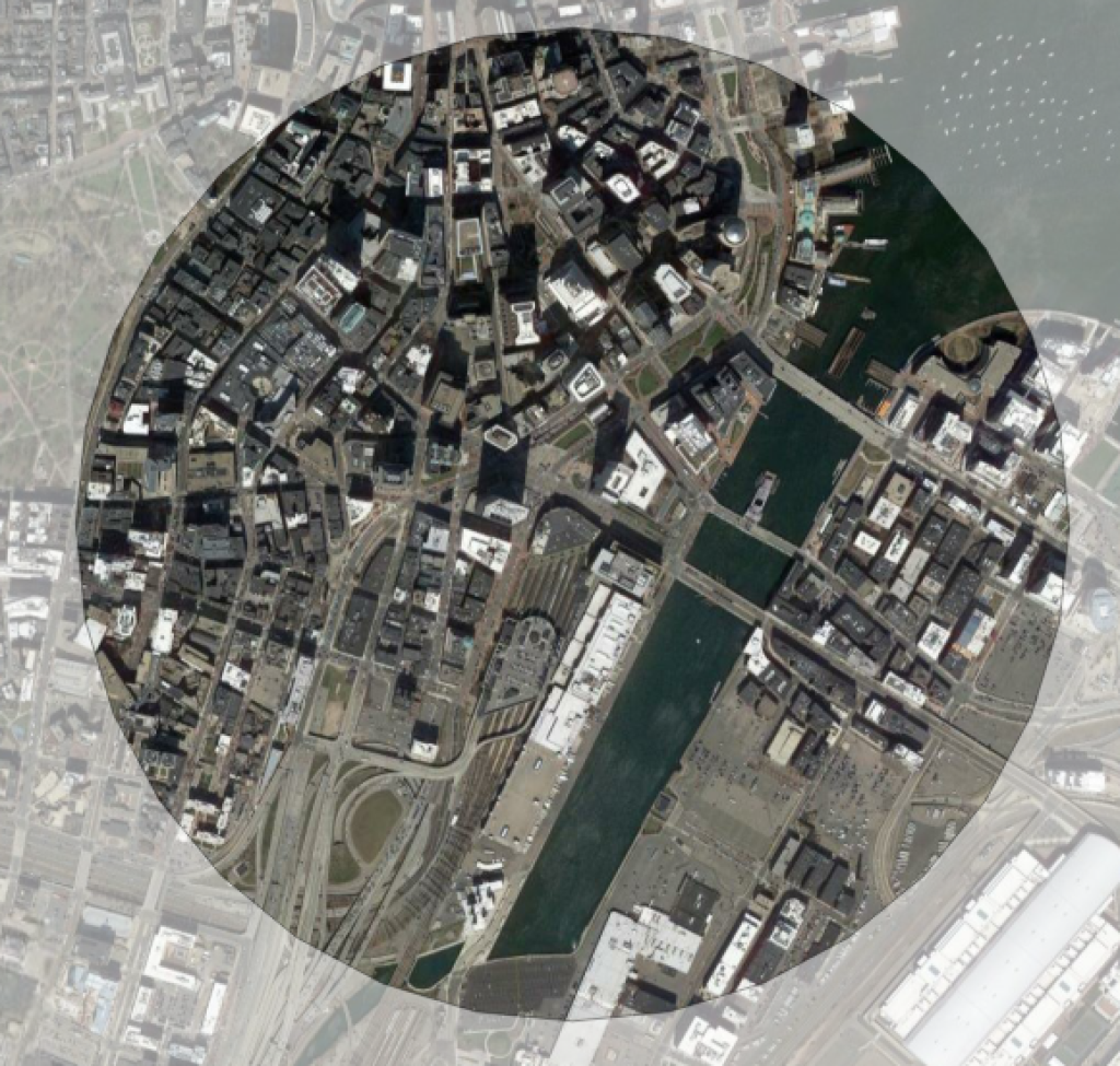
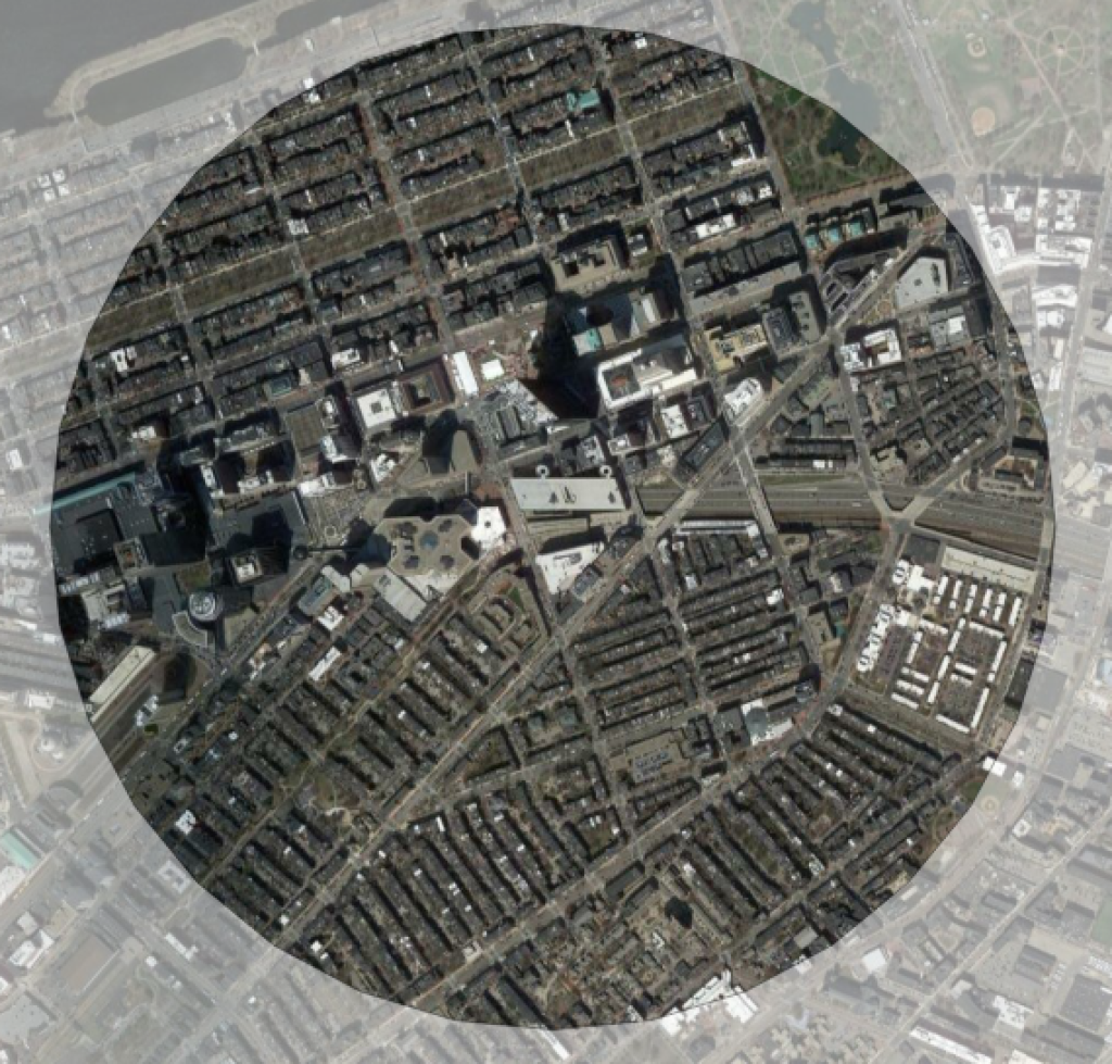
Let’s look at the current downtown stations in Boston. Here’s South Station and Back Bay, showing everything within a half mile:


South Station is surrounded by some highway ramps and water, but otherwise well-located in between the Financial District and the Seaport, and it also has a Red Line connection. Now, here’s North Station:

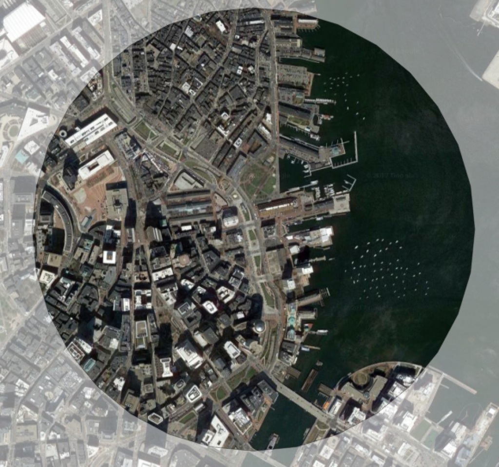
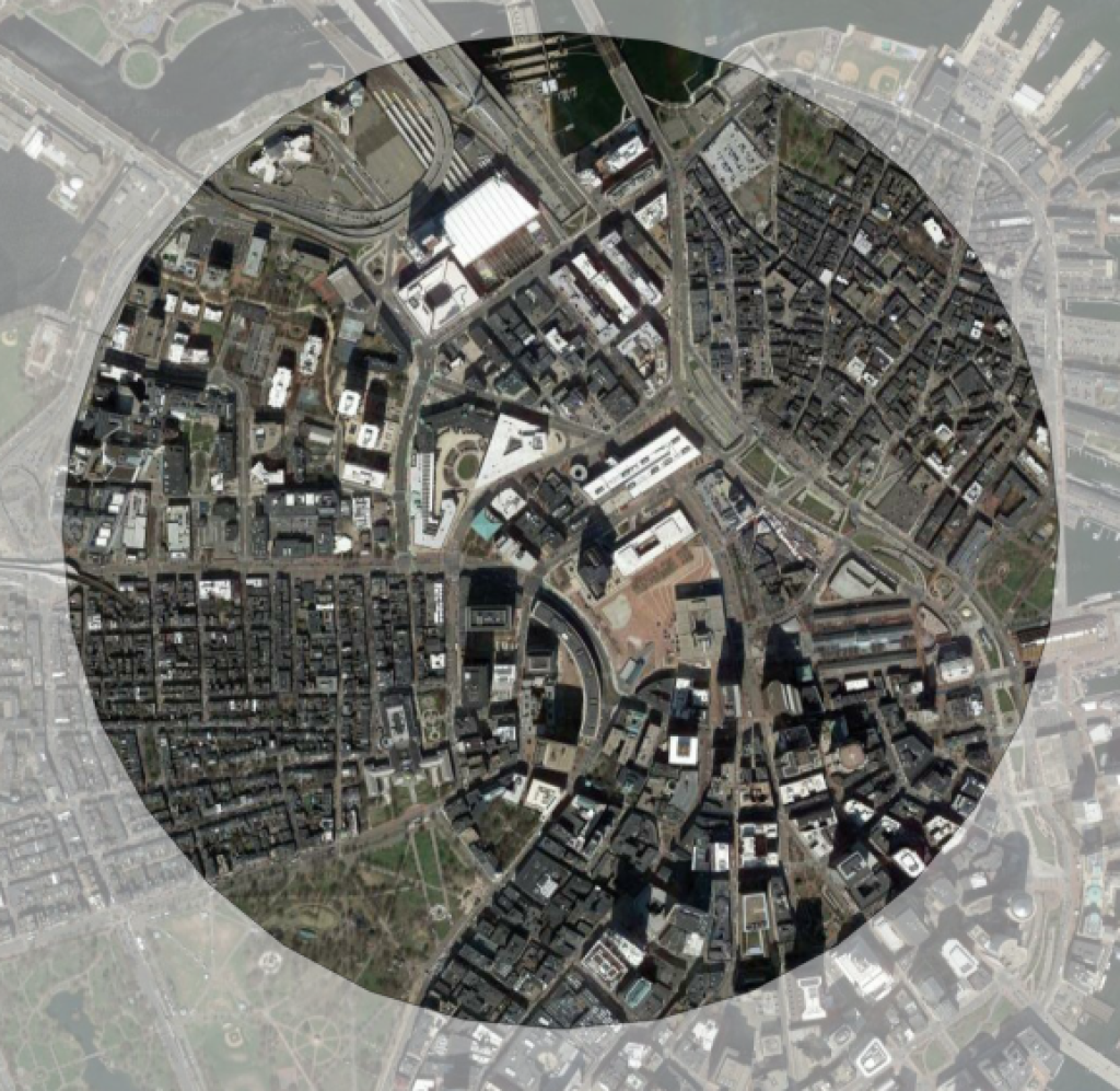
See the problem here? Note how nearly everything to the north of North Station has no real use: it’s highway ramps, river, and parking lots. No housing. No jobs. So that when people get off the train at North Station, they almost invariably walk south, towards South Station. You could move North Station half a mile south and pretty much everyone would still be within half a mile of the train station. North Station has never been in the right location, but is there as an accident of history: it was as close in as they could build a station nearly 200 years ago (well, a series of stations for several railroads) without bulldozing half the city. It’s the right place for a surface station, but if you have the chance to build underground, it’s not.

Most NSRL plans try to mitigate this with a third, Central station, somewhere near Aquarium Station, but this has the same issue as North Station: half of the catchment area is in the Harbor:

This would give you three stations doing the job of two. Each train would have to stop three times, but the two northern stops could easily be replaced by a single stop somewhere in between. I nominate City Hall plaza. It would connect to the Orange, Green and Blue lines (at Government Center and Haymarket) and, if you draw a circle around it, it wouldn’t wind up with half of the circle containing fish.

North Station would still be served by the Orange and Green lines, and it would allow the North-South Rail Link to serve the efficiently and effectively serve the greatest number of passengers. A pair of stations in Sullivan Square and near Lechmere could allow regional access to the areas north of the river, which would sit on prime real estate if the tracks were no longer needed (they’d be underground). Since stations are much more expensive to build than tunnels (you can bore a tunnel more easily than a station), it might wind up cheaper, too.

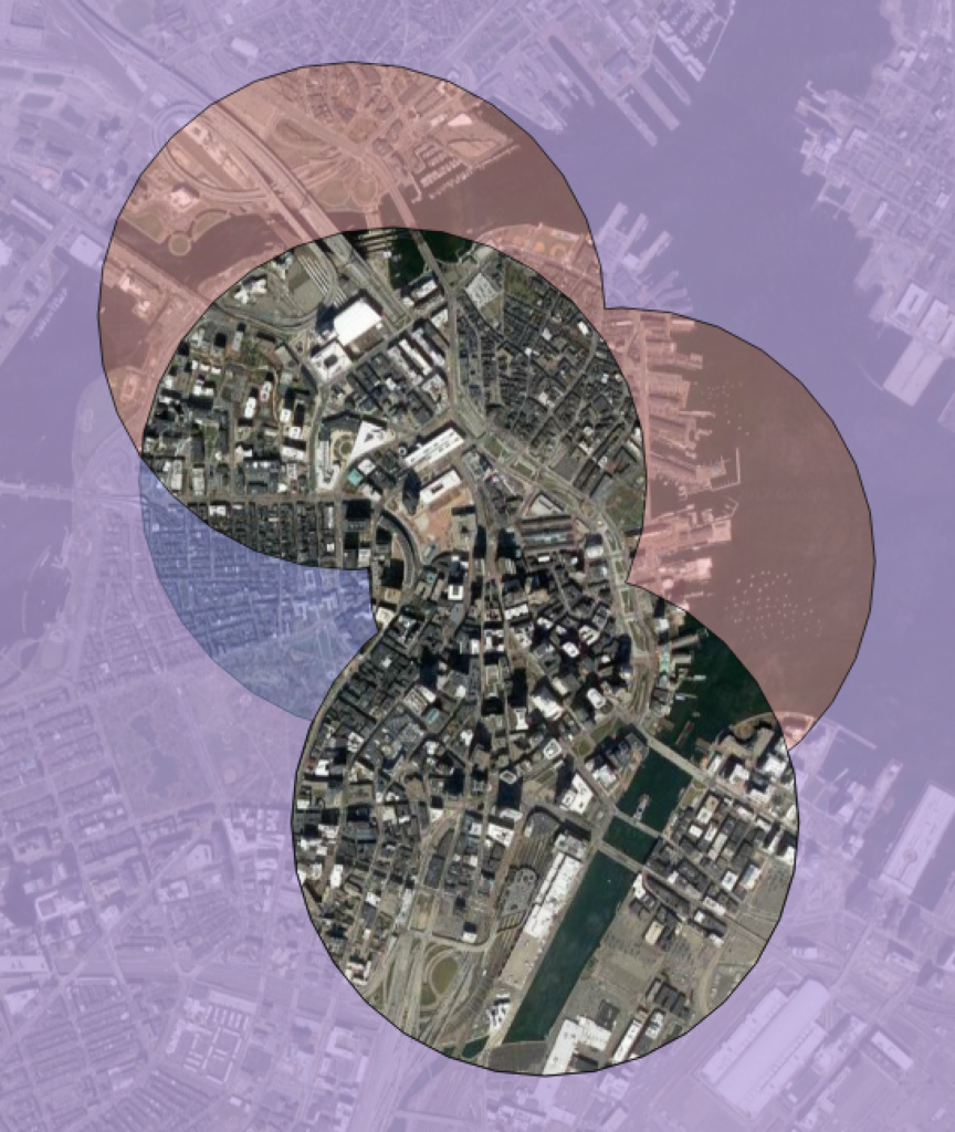
Putting it all together, here’s a map showing the areas accessible under both the two-station and three-station schemes. Shown without any shading are areas within half a mile of the stations in both plans. Red areas are areas which are within a half mile of the three-station plan but not the two station plan, blue areas are within half a mile of stations in the two-station plan but not the three-station.

This shows that if you are willing to put a station in the vicinity of Government Center, you can get the same coverage in downtown Boston with just two stations. You lose the areas shaded in red, but these are mostly water and highway ramps. Instead, you gain most of Beacon Hill and the State House. It seems like a fair trade. (Yes, you lose direct access for Commuter Rail from North Station during major events at the Garden, but a Government Center/Haymarket station would only be a six minute walk away, or a two minute ride on two subway lines.)

In Commonwealth Magazine, I said that we shouldn’t double-down on the mistakes of the past by building larger, inefficient stub-end terminals. The same goes for North Station. The station itself is in the wrong place. If we build a North-South Rail Link, there’s no need to replicate it just because it’s always been there. Downtown Boston is compact enough it only needs two stations (plus the third at Back Bay). North Station isn’t one of them.

Improving the Providence Line as a stepping stone to Regional Rail

Of all the peculiarities in the MBTA’s Commuter Rail operation, one of the most apparent is the Providence Line. Where else can you find a modern, high-speed, electrified railroad with diesel-powered trains operating underneath the wire? Basically nowhere. Yet the MBTA incongruously runs diesels on the line, and not only that, it doesn’t spec its equipment for more than 80 mph, so the trains run at half of the top speed. The Providence Line is the system’s busiest, with upwards of 1000 passengers boarding daily at each station, but most board via the trains’ steps, lengthening dwell times considerably. It’s a 21st century railroad, but the MBTA runs it like the 19th. This provides far worse service than it should and costs the T—and the taxpayer—a lot of money while providing far less public benefit, in terms of regional connectivity and short travel times, as it could. Electrification would also allow for much more efficient utilization of equipment: with the same number of crews and cars on the line today, it would allow twice as many trains at rush hour.

Electrifying the Providence Line for the MBTA would not be trivial, but the costs would be relatively low given the existing infrastructure, and it provide benefits not just for Providence Line riders but for Amtrak riders and nearby residents. It would allow the diesel equipment on the Providence Line to move to other parts of the system, replacing the oldest equipment elsewhere. It would also be the first step towards building Regional Rail: a rail system which not only takes workers downtown at rush hour, but also provides mobility across the region. And where better to start than between the capital cities of Massachusetts and Rhode Island?

This post will address several of the benefits of upgrading the Providence Line to accommodate fast, electric rolling stock, and how they will allow the MBTA and RIDOT (which subsidizes the portion of the line serving Rhode Island) to increase service, decrease operating costs, and provide a better, more competitive product on the rails. With the MBTA’s fleet aging, it’s high time to examine the future needs of the network, and to begin the move to electric operation and a Regional Rail system.

Electric trains are cheaper to buy

The MBTA’s most recent locomotive procurement had a unit cost of $6 million. The unit cost for the M8s delivered to MetroNorth has been in the range of $2.25 to $2.5 million, about the same as an MBTA Rotem bilevel coach. While the bilevel coaches do have more capacity than the single-level cars, a locomotive and six bilevels has the same capacity and costs the same amount as a train of eight EMUs. (Bilevel EMUs are also an option, although Northeast Corridor-spec’ed bilevel equipment does not yet exist, New Jersey may order some soon. If so, costs may not be appreciably be higher. Single level equipment with a proven track record could be bought off the shelf.)

Edit Dec 2018: The FRA has finally updated rules which would allow the T to buy European-spec equipment, like Stadler FLIRTs, which are significantly lighter than an M8 and have better acceleration. Here’s a video of a FLIRT accelerating to 100 mph in 72 seconds.

An electric locomotive pulling bilevel coaches would not have the acceleration benefits afforded by EMUs, but it would still be faster, and the cost of an electric locomotive is about the same as a diesel. Both electric locomotives and EMUs have a proven track record, running daily around the world, including on much of the Northeast Corridor.

In the relatively near-term, the T needs to buy new rolling stock. The T’s entire single-level fleet dates to before 1990; 55 of the cars were built in the ’70s; once the Red Line cars are replaced, they will be the oldest in the system (except, of course, the Mattapan Line). About half of the T’s locomotives date to the same time period, with 20 of them dating to 1973. It is no wonder that the agency is constantly short on both cars and motive power.

The T has had little luck buying new diesel equipment: the 40 new locomotives in the fleet are back and forth to the shops on warranty repair, and coaches aren’t much better: the Rotem bilevel cars are plagued with problems. So instead of doubling down on diesels that don’t work, the T could buy something that does: electric power. Replacing the Providence Line would free up a dozen-or-so train sets, which could be spread across the rest of the system to replace aging diesel equipment there. Thus, the up-front marginal cost of buying new trains would be effectively zero: the T needs to buy new Commuter Rail equipment anyway.

Electric trains are more reliable

Buying electric trains means buying a superior product. While they aren’t perfect, electrics have a much better track record of not breaking down. There’s no perfect metric for this, as I’ve mentioned before, since it is based on agency policy, but the numbers are so staggering they’re almost hard to believe. The T itself reports that its trains break down approximately every 6,000 miles. Meanwhile, the mostly-electrified Long Island and Metro-North railroads see approximately 200,000 miles between major mechanical failures. (A completely different calculation from Chicago shows similar results: the T is way below its peers.) A more apples-to-apples comparison can be made between different equipment types on the LIRR, where the new electric power breaks down ten times less frequently than diesels. While I’d take some of these numbers with a grain of salt, it’s clear that electric-powered railroads are more reliable than diesels.

Another of the costs of running Commuter Rail trains is fueling. Not only does it require staff and fuel, but the trains have to be moved to a fueling location in the middle of the day, which requires additional personnel and operating time and cost. Electric trains carry no fuel, and don’t have to make frequent trips to a fueling facility. They also don’t have to be plugged in or idled at the end of the day: the power to keep them on and get them started is always flowing above the track.

Electric trains are cheaper to run

In addition to the cost of electricity being less volatile than diesel, electric trains are simply cheaper to operate. This is somewhat less the case in the US, where every multiple unit is treated like a locomotive and subject to more stringent maintenance, but the costs are comparable, if not lower. This is especially the case for shorter train sets; if some trains on the Providence and Stoughton Lines used fewer cars, the costs would be significantly less. A locomotive-hauled train uses basically the same amount of power whether it’s pulling four cars or ten. A set of EMUs could easily be broken in half for midday service, reducing operating costs. A study of electrification in Ontario shows annual operation and maintenance savings of 25% (the full study, here, is worth a read). And this assumes low diesel prices. If the cost of oil spikes, electrics pay further dividends.

Electric trains and level-boarding platforms mean faster trips

The fastest trip time for MBTA equipment between Providence and Boston is currently 1:00 (for a 5:30 a.m. outbound trip) with some trips taking as long as 1:14. Amtrak’s Acela Regional trains make the trip in 38 minutes (the Acela Express trains make it in 33). Each stop adds about one minute and 45 seconds to the trip, so additional stops at Sharon, Mansfield and the Attleboros would add 7 minutes, for a total of approximately 45 minutes, end-to-end (Alon levy calculates similar numbers). A commuter from Providence would save half an hour every day; from closer-in stations, round trips would be 20 to 25 minutes faster.

High level platforms are just as important (see this post from California for a very similar issue). Today, Commuter Rail trains will spend two or three minutes of time stopped at major stations while hundreds of people climb the steep, narrow steps onto the cars. High level platforms—like those at Route 128, Ruggles, Back Bay and South Station—allow much faster boarding, increasing the average speed and decreasing the amount of crew time necessary to operate a train. They should be added to all stations, but the busy Providence Line stations are a good place to start.

Faster schedules mean more trains

The total amount of rolling stock required for a railroad is based on the peak requirement for rush hour. Currently, most equipment on the Providence Line runs one rush hour trip in the morning, and one rush hour trip in the evening, with some service midday. For some larger train sets, however, these are the only two trips which are run during the day: a large capital expenditure which is only used 10 hours per week. The first train leaving Providence 5:00 a.m. can make it back to Providence in order to run a second trip that gets to Boston around 9:00 (likewise, a 4:00 p.m. departure can be back to South Station by 6:30, after the tail end of the peak of rush hour) but everything else can only run once inbound in the morning and once outbound in the evening. This approximately 2:40 time (based on stopping patterns and layover) is called the “cycle time” of the line, and the amount of equipment needed to run service is based on this.

Now, imagine that you drop that 2:40 cycle time to 2:00 (45 minutes of running time and 15 minutes to turn at each terminal). That 5:00 a.m. train can run a second trip in to Boston at 7:00. (and maybe even a third at 9:00!). This is much more efficient: each train set can provide twice as much service.

To run service every 30 minutes, you only need four trains. Or, with the eight trains currently needed to run rush hour service from Providence, you could run trains twice as often: every 15 minutes. So instead of the current eight departures from Providence (and one short-turn from Attleboro) between 5:00 and 9:00 a.m.—with as much as 50 minutes between trains—you could instead have 16 departures from Providence: one every 15 minutes. This gives you double the capacity (and if trains are 15 minutes faster than today, you may well need it) and walk up service between the two largest cities in the region.

Off-peak, instead of running a train every one to two hours (or longer: there are service gaps of 2:20 in the current schedule), you could have a train every 30 minutes, again, with the same number of trains. (For the Stoughton branch, a short train could shuttle back and forth between Canton Junction and Stoughton during off-peak hours, meeting the mainline trains at Canton.) This is the promise of Regional Rail: fast, frequent, predictable and reliable trains throughout the day. Electrification and high level platforms would allow the T to operate this level of service with no more operating cost than today.

What’s more, much-improved weekend service on the line would also be possible. Today, there are trains only every two or three hours, and on Sundays, basically no service before noon. (This dates back to the days when the New Haven Railroad operated the service and didn’t provide service before noon, ostensibly because the parochial New Haven thought its customers should be in church, not riding the trains.) Hourly weekend service would be possible with just two train sets.

To visualize this, we can use what’s called a “string diagram” of the current MBTA and Amtrak service during the evening rush hour. The morning rush hour is less complex as there are fewer Amtrak trains in the mix since, except for one overnight train, the first Amtrak arrival from New York doesn’t arrive until close to 9 a.m. Each line shows a train running along the line; steeper lines show slower service. Purple lines show Commuter Rail trains, Light blue lines Amtrak regional service, and dark blue lines Acela Express service.

And here’s the same diagram, but showing every-15-minute EMU Commuter Rail service:

Notice how in the first diagram, purple and blue lines cross (this causes longer trips for Commuter Trains if they’re on time, and delays for Amtrak if they’re not) and how sparse the schedule is, that from 4:55 to 5:40, there are no Commuter Rail departures to Providence to let Amtrak run two trains out in quick succession. Note that in the second chart the slopes of the lines are much more similar, allowing trains to operate in closer proximity.


Electric Commuter Rail improves Amtrak service

With straight track, Massachusetts has some of the fastest track that Amtrak operates. Between Back Bay and Providence, Amtrak tops out at 150 mph, with 36 straight miles where the speed limit is 110 or higher. Acela Express trains attain an average speed—start to stop—of 102 mph between Route 128 and Providence. Yet across this line, the MBTA operates at at top speed of just 79 mph; with slow diesel acceleration (since the power plant on board a diesel electric locomotive is significantly less powerful than what can be pulled off the grid and put in an overhead wire) and boarding, peak trains make the trip averaging just 42 mph. In fact, going up the hill from Sharon, a fully-loaded eight-car set commuter set being pulled by a 4600-hp diesel doesn’t even have enough power to accelerate to 79 mph before it has to slow down for Mansfield. (Electric trains hauled by a 6700-8600 hp motor or EMUs with 1000 hp per car do not have this issue.)
This creates a scheduling nightmare. An Amtrak train needs miles of clear track between Route 128 and Providence to proceed safely, but the line is occupied by slow-moving commuter trains at rush hour. This leads both to long gaps in Commuter Rail service (for instance, there’s no train leaving South Station between 4:55 and 5:40) and cases where commuter trains sit on the side track at Attleboro for several minutes to clear the line so Amtrak can pass (this happens at both 4:45 and 5:45 during the evening commute), which can be seen on the first string diagram above.

Improving speeds with electrification and high-level platforms would solve these problems. Regional Rail speeds between 128 and Providence would increase to an average of 66 mph (including stops), causing significantly less interference in the schedule. By varying the departure times of some trains (having them leave three minutes before the clock-face schedule would require) they would arrive at Providence—which has four tracks and platforms, so an Amtrak train can easily pass—four minutes before the express Amtrak train. And if a local train is running late, it can still use the passing tracks at Attleboro to let an Amtrak train pass.

The T has some leverage to negotiate with Amtrak

Unlike most of the Northeast Corridor, the MBTA owns the track on which it, and Amtrak, operate. The T bought the right-of-way from the bankrupt Penn Central in 1973, and since then has cooperated to allow Amtrak to use the line in what is known as the Attleboro Line Agreement. Amtrak, in return for maintaining the line and dispatching trains, has used the line for free since then. A recent change in federal policy led to dueling lawsuits between Amtrak and the MBTA (where Amtrak was demanding the MBTA pay Amtrak for the use of its own line) and the they agreed on a smaller, but still significant, amount the T would pay Amtrak, even though the MBTA owns the railroad.

This means that if the MBTA were to increase service, it would have some leverage with Amtrak: it’s not a tenant railroad the way New Jersey Transit, SEPTA and MARC are. The T could demand that some of the funds it pays to Amtrak are directed towards improvements to the line in Massachusetts. It is in Amtrak’s interest, because dispatching high-speed trains would be much simpler if the rest of the trains on the line were fast, too, and that can only happen with better infrastructure.

Rhode Island benefits, too

In addition to the Attleboro Agreement, the Pilgrim Partnership has, for three decades, provided MBTA service—as subpar as it is—between Providence and Boston. In recent years, RIDOT has overseen the extension of the line to TF Green Airport and Wickford Junction, but with minimal ridership. One issue is the speed of the line: it takes 32 to 40 minutes for trains to make the 19 mile trip from Providence to Wickford Junction, even as Amtrak trains make it 45 miles across the Connecticut state line in that same amount of time. RIDOT has commissioned a study for in-state rail service, which looks at several options, including using EMUs.

The service, as currently operated, does not make sense. The demand profiles between Providence and Boston are very different than they are south of Providence. It would make sense to split the Boston-to-New York corridor in to three segments: Boston to Providence, Providence to New Haven, and New Haven to New York. On either end, passenger demand requires frequent, high-capacity train service. In between—from Providence to New Haven—shorter trains can be operated more frequently than Amtrak’s current schedule (some towns see only two or three trains each day). Amtrak’s bread and butter is intercity service: it should stop at Boston, 128, Providence, New Haven, Stamford and New York. One of RIDOT’s alternatives does just this, combining Rhode Island local service and Shore Line East. This makes sense. Coordinated service between smaller cities should feed into this higher-speed system, saving time for the majority of riders between Boston and New York while providing more-frequent, and only slightly-slower, service to the smaller towns in between.

How to upgrade the Providence Line

To build Regional Rail between Boston and Providence, here’s what you’d need to do:

  1. Upgrade the electrical systems to allow more power to be distributed across the line. Luckily, someone had their head screwed on straight when it was built and it was designed to have additional power dropped in to place. The T could negotiate with Amtrak to use its $20 million annual “blood money” for this.
  2. Extend power over any unpowered tracks on the NEC and on the Stoughton branch. This amounts to only a few miles and Stoughton is short enough that it shouldn’t need significant distribution infrastructure. Wires are cheap. Substations, which wouldn’t be necessary, cost.
  3. Build high-level platforms at Hyde Park, Sharon, Mansfield, Attleboro and South Attleboro stations. This will allow the purchase of rail cars without any “traps” or steps, and will allow much faster boarding and alighting via all doors on a train. It would also make these stations—each of which serves more than 1000 commuters per day—fully ADA compliant.
  4. Requisition and procure approximately 120 EMU rail cars for operation on the Providence and Stoughton lines, in four-car train sets (or perhaps pairs to allow two-car trains south of Providence and at off-peak times). Peak service from Providence and Stoughton to Boston would require 11 train sets (88 cars), Rhode Island two four-car trains (8 cars), with the required number of spares. The Federal Railroad Administration may allow lighter, faster European-style EMUs to operate on lines like this (update, it has, see above), which would further reduce the cost.
  5. Build a light-maintenance facility at or near the Pawtucket layover facility, the former Attleboro layover or perhaps in Readville. If built in Rhode Island, the Ocean State could foot these costs in return for maintenance jobs in state. Light maintenance could be conducted locally, with Metro-North contracted for major running repairs at its New Haven facility, at least in the short term. The trip from Providence to New Haven wouldn’t take much longer than the current trip from South Station to Boston Engine Terminal via the Grand Junction, and cars could even be sent attached to Amtrak’s overnight trains or in service in the Rhode Island-Shore Line East scenario.
  6. Move current rolling stock used for Providence and Stoughton to other MBTA lines, retiring the oldest and least-reliable equipment, and mitigating the car shortage on many lines. Rather than buying balky diesel equipment, procure off-the-shelf designs proven to work in other markets, and put them to work here.
One caveat would be capacity constraints at South Station (although the Providence Line, with 15 minute turns at rush hour, would only require two tracks, with an additional track for Stoughton) and slots on the Northeast Corridor to where the tracks split at Readville. Some trains could be slotted ahead of Amtrak service (where there are 10+ minute schedule gaps, more than enough time for a train to get to Forest Hills or Readville and then clear the line). Franklin Line trains in the non-peak direction could be routed along the Fairmount Line at rush hour to free up slots as well. The Stoughton Line could be run as a shuttle from Canton Junction, which would eliminate a one-seat ride for Stoughton passengers, but provide much more frequent service than the once-an-hour service to Stoughton. In the long run, a North-South Rail Link would obviate the need for South Station expansion.
For too long, Commuter Rail has been the ugly stepchild of transit in Massachusetts. Even as the region hosts the fastest trains in the Western Hemisphere, the MBTA operates far slower than it could. Other than “we’ve always done it that way,” there’s no reason for this. This is a small investment which would would pay for itself in increased ridership, lower operation costs, more efficient fleet use and the economic development from closing the distance between Boston and Providence (which itself is hardly a backwater). This would also bring lower-cost housing along the corridor within easy commuting distance of Boston, and bring two of the largest cities in the region closer together. It needs leadership and forward-thinking people at the T and RIDOT to step slightly outside their comfort zones. But it is certainly not impossible.

Lyft Shuttle doesn’t solve congestion, it creates it

Recently, Lyft launched what they call “Shuttle” and what everyone else calls “the bus.” It is an exceedingly inefficient bus, given that it has a maximum occupancy of 4 (but an average of likely between 1 and 2). Everyone made fun of them, so they wrote about how, no, it’s actually great, because it’s not a bus, even though it acts like one, and it will reduce car ownership and expand mobility.

And what they wrote is, well, kind of infuriating, but a good lesson as to how ride-hailing, even if it’s one day autonomous, will not solve congestion, and may just make it worse. It shows that Lyft not only seems to have no understanding of how transit economics work, but also no understanding of how their own service works, assuming that vehicles can just appear at random to fulfill demand. Their argument begs to be broken down line by line, so I’ll do that. Original indented, my comments in italics.

Recently, Lyft started testing a new product called Shuttle in two cities: Chicago and San Francisco. I’ve seen quite a few thoughtful questions — and a few good jokes — circulating about Shuttle. So as one of Lyft’s longtime resident transit nerds, I want to take the time to share why we launched Shuttle, and what it means for cities and the future of public transportation.

Okay, so you’re a transit nerd. Great! Let’s see how well you understand transit.

What is Shuttle? 

You can think of Shuttle as a new twist on Lyft Line, the popular dynamic carpooling option we launched in 2014, which is available in 16 cities and accounts for around 40% of all rides in those markets. Just like Line, Shuttle matches you up with other passengers going the same direction to create a high-occupancy ride for a lower price than riding alone (more people in fewer cars = win). The twist is that unlike Line, Shuttle pick-up and drop-off locations are the same every day, and so are the prices (with prices between $3–4 per ride, Shuttle is Lyft’s most affordable service, offering commuters a reliable option for far less than the average cost of car ownership, which is about $9,000 per year). And instead of coming straight to your door, Shuttle picks you up at a safe, carefully selected spot nearby.

The main quibble here is the $9000 cost of car ownership. That assumes that you live in the suburbs and actually drive your car all the time! But the rides described here are generally 2 to 5 miles. Let’s assume 5 miles, both ways, 250 work days per year. That’s 2500 miles. Yet the $9000 figure is based on 15,000 miles per year. If you don’t have a car, Lyft will save you all the fixed costs of ownership, but if you want to go somewhere outside of commute times, you have to pay the full cost per mile in rental fees and short-term insurance. (Or take a Lyft/Uber, but that’s relatively expensive, too.) And if you do have a car, Lyft is only saving you the marginal costs of about 15¢ per mile, which for 2500 miles comes out to just $375, but you’ll pay $2000 for the Lyft rides (80¢ per mile, which is quite a bit more, per mile, than car ownership). You won’t, at least, have to pay for parking.

As many on social media pointed out, these new features are also found in traditional public transit buses. Fair enough. But here’s what’s different and important. 

Shuttle rides are provided by the same, awesome Lyft drivers you know and love, driving their own cars — not big vans or buses.

This is a bug, not a feature! The reason why transit works economically is because it uses larger vehicles: it can scale by carrying more passengers with the same number of drivers. Sure, a 40-foot transit bus isn’t efficient if it’s carrying two passengers, but in a city like Chicago or San Francisco, it’s not. In the corridors Lyft Shuttle serves, buses in the peak are generally full. That’s much more efficient than a car, even one carrying three passengers.

As a driver in a Shuttle market, your next ride request could be an original Lyft, Line or Shuttle request; they’re all part of the mix. That means no one needs to go buy any new vehicles to turn on a Shuttle route, and they are easy to change based on feedback. And unlike a bus route, a Shuttle route is on-demand — it doesn’t happen unless a passenger requests it.

So are bus routes. None of the routes in the Shuttle areas have empty buses (or trains). In fact, the buses there are well-used enough that frequencies are based not on some minimum level of service (a bus every 15 minutes, for example) but to meet passenger demand, some as frequently as every four or five minutes. 

That means Shuttle is very efficient, never making drivers circle and waste miles when people aren’t riding it. Instead, drivers just move on to give other Lyft requests after they finish a route, or log out if requests slow down.

This completely misses the fact that cars don’t appear and disappear but have to come from somewhere and go somewhere before and after a trip, usually not carrying passengers. If a driver gets downtown and drops off a fare and finds there isn’t much demand (since at morning peak hour, there is far more demand going to downtown than leaving, with the opposite in the afternoon) the car doesn’t just go *poof* and disappear, but it has to be driven somewhere else. The problem here is two-fold: first, this creates additional congestion, since transporting passengers for 4 miles might require the car to drive an additional 4 miles in an already congested area without any passengers. If the system were perfectly balanced with trips into and out of the core, it might work, but in San Francisco and Chicago, at rush hour, this is certainly not the case.


Second, the driver of this vehicle is not compensated for this time, so it eats in to their already-low wage. This speaks to an obvious flaw of the system: at the current price of $4 per ride, it’s completely unsustainable. Let’s assume that Lyft carries an average of 3 passengers per trip at $4 fare each. That’s $12. Lyft takes 20% off the top, so the driver is getting $9.60. The marginal cost of a 35-minute, 4 mile trip in rush hour is probably $1 for gas and maintenance, but then the driver has to deadhead (operate without a fare, while still incurring the costs of operation) to and from the next fare, which likely adds another 4 miles ($1) and 15 minutes. Now you’re earning $7.60 for 50 minutes of work, or $9.12 per hour. And that’s sort of a best-case scenario, and assumes you have relatively little time in between fares, and doesn’t account for time spent pumping gas, cleaning the vehicle, and other items. If we assume that every other trip, a driver will have no fare and have to deadhead 8 miles ($2, 30 minutes) out of the city, the economics collapse: the average hourly wage falls to $6. And while there is some affordable housing within 8 miles of Chicago, there certainly isn’t that close to San Francisco.  

This form of flex transit capacity augments the fixed capacity of traditional transit routes at peak times when those services are maxed out with riders, brings “right-sized” service into areas which can’t support traditional transit, and melts away when it isn’t needed.

This sentence is trying to have it both ways! If traditional transit routes have fixed capacity, it means that they are full, and if they are full, it means that it doesn’t serve an area that can’t support traditional transit. None of the corridors described are in areas that don’t support traditional transit, of course. And then the “melting away” phrase doesn’t account for the fact that it would wind up with a bunch of empty vehicles driving away from downtown, adding to congestion and pollution.


This is the problem with ride-hailing and (potentially eventually) autonomous vehicles. It may reduce the number of parking spaces we need, which would be a good thing. But unless the system is perfectly balanced—and in cities, it inherently is not—parking will be traded for more vehicle miles traveled (VMT). More VMT means more congestion. Is this a good trade? I’m not so sure. 


This is a problem in the transit industry as well: full buses come downtown, drop off passengers, and operate empty to a garage to sit idle for the middle of the day. But it’s an order-of-magnitude bigger problem for smaller vehicles: a bus can carry 60 passengers and make one empty trip. Cars—even with three passengers each—would require 20 such trips with 20 outbound drivers.

Shuttle’s initial routes were chosen by our data scientists, who looked at the density of Lyft Line requests during commute hours and picked a small set of initial corridors where the data showed we would be able to match up the most passengers, enabling the highest occupancies and thus the lower prices passengers want.

Or the low prices which can entice people into these cars. As mentioned above, these prices are nowhere near sustainable. Plus, passengers don’t really want high occupancy. If they did, they’d ride the bus; if they didn’t, they’d drive instead. Four passengers means someone has to sit in the middle seat, which is likely less comfortable than a bus line. (And on a bus, you can at least move to another seat or part of the bus if you’re uncomfortable with the person next to you. Try that in the middle seat of a Corolla.) If Lyft regularly has four passengers per driver, customers will abandon the service. The practical maximum number of passengers is 3, making the average less, making the math shown above a rosy estimation.

Not surprisingly, many of these corridors align with those most heavily used by other transportation modes, including personal cars and transit. With Shuttle, we hope to reduce the need for commuters to drive their own cars on those busy corridors, giving them a more efficient option and freeing up road capacity for high-efficiency shared and transit vehicles.

This is a nice sentiment, but it only works if significantly more people switch from driving to Shuttle than from transit to shuttle. Let’s imagine a congested corridor with a bus carrying 100 people and 100 cars carrying one person. In many cases, the corridors Lyft Shuttle is serving have 2-to-1 transit-drive mode share (and that’s for all trips, it’s probably even higher for trips to the core, see this map of Chicago, for instance). If 45 riders take shuttle at a 2-to-1 transit-to-driver ratio, this would add 18 vehicles to the roadway while removing 15 cars, meaning it would be less efficient and would certainly not free up road capacity. (This assumes zero deadhead mileage, which adds further congestion while providing no benefit.) Given recent trends of ridership declines on transit and increased congestion, Occam’s Razor would suggest that’s exactly what happens.

We’re For Transit  

You might have noticed that Shuttle sounds like some hybrid mashup of ridesharing and transit. You’re not wrong. It fits into a new category experts call “microtransit,” and it’s designed to do things buses can’t do and reach people buses don’t reach, helping attract a broad spectrum of riders who haven’t used transit before.

Microtransit doesn’t really work. Bridj failed to make money or expand beyond Boston, even with larger vehicles than Lyft Shuttle and fares in the $5-$6 range, except for a publicly-funded foray into Kansas City. In that case, the year-long pilot project had 1480 riders. Not per day, total. At a cost of $1.3 million, it was a subsidy of $878 per ride. That pilot attempted to do things buses don’t, reach people buses can’t and bring in new transit riders, and it didn’t exactly work. The most successful microstransit provider, Chariot, runs a few fixed route transit-style services in San Francisco, but mostly serves corporate-subsidized routes to suburban campuses. 

The Lyft team is made up of strong public transit advocates (some might say geeks), a tradition that started with our co-founder and CEO, Logan Green.

Remember when your middle school teacher—and Hemingway, apparently—would say “show, don’t tell”? It’s a rhetorical tell when you have to open every paragraph by telling us how you really, truly love transit. 

We come to this issue with a deep empathy for and exposure to the challenges facing traditional public transit operations. Over a decade ago, Logan served on a public transit agency board in Santa Barbara, California. He lobbied hard to improve the frequency of bus service in the city’s low-density neighborhoods to benefit riders who depended on buses, only to find that the transit agency couldn’t afford it. There just weren’t enough riders to fill more buses on those routes.

Yet Lyft Shuttle serves areas so dense that the only reason they can exist is because of transit. If Santa Barbara needs Lyft Shuttle so much, maybe it should try to operate there.

Never one to take no for an answer, Logan was inspired by the informal jitney networks he saw on a trip to Zimbabwe and became determined to find another way to expand mobility access.

Yes, since Zimbabwe is a perfect corollary for the Loop in Chicago. And in many cases, third-world jitney networks have been replaced with, you guessed it, transit.

His vision was to turn every single-occupant vehicle on the road into an extension of the transit network, which would cut traffic and make it easier for everyone to get around at a low cost — especially people who couldn’t afford to own cars. 

But Lyft and Uber don’t do that: they add vehicles to the roads and generally increase traffic in already-dense areas.

Shuttle is the latest step in making that vision happen. In parallel, we’re also continuing our strong policy advocacy for expanded investment in traditional public transit, such as Measure M in Los Angeles, Proposition 1 in Seattle, and Measure RR in the Bay Area, all of which were passed by voters last fall. Our country must break down the traditional binary between cars and transit and embrace all of these strategies if we want to make gains in reducing reliance on car ownership.

The whole point of not owning a car is to not drive a car.  Or if you don’t you want to save the money you spend owning a car and dealing with the hassle? Ride in a car but have a chauffeur, we’ll explain how for some reason that’s cheaper. (It’s not, except in small doses.)

How Shuttle fits in with Transit  

New, creative and efficient ways of delivering transit are sorely needed. For over a century, public transit agencies have had two basic tools for getting people around cities: buses and trains. Like any tool, buses and trains work really well for some tasks, and not very well for others. For moving large volumes of people along heavily-traveled corridors during commute times — buses and trains can’t be beat.

So, you mean, basically every corridor Lyft Shuttle operates in. Downtown San Francisco has more transit commuters than drivers from the city. The corridors in Chicago are similar: for travelers to the Loop, 189,000 take transit, 81,000 drive.

They move the most people at the lowest cost while taking up the least space on the road — IF they are able to attract enough riders.

Again, this doesn’t seem to be a problem in Chicago or San Francisco.

But for routes where there are smaller numbers of riders, traditional buses and trains struggle to provide frequent, cost-efficient service, and ridership suffers accordingly, leaving riders in those areas with few efficient options. We think Shuttle can help bridge these gaps, and it’s one reason why we launched an initial test route in a transit-underserved area on Chicago’s South Side that connects to Downtown from Brighton Park. 

That pilot would be useful if there weren’t any transit options from Brighton Park to the Loop. But there are: the Orange Line or the six bus lines which serve the neighborhood every 10 minutes or better at rush hour.

The vast majority of Americans live in places outside of mass transit’s “sweet spot” — which is why only about ⅓ of jobs in major U.S. metropolitan areas are reachable by the average commuter within 90 minutes one-way by public transit.

But downtown San Francisco and Chicago are not exactly transit deserts.

And many potential transit riders live too far away from train stations to be able to use them, a classic challenge known by transit agencies as the first-and-last-mile problem.

What about bus stops? Buses are bad, but using smaller cars as buses is great?

Here again, we think Shuttle can help. Since launching Shuttle in San Francisco, we’ve found that our single most successful route is a first-and-last-mile connector to the 4th and King Caltrain station.

Then run a last-mile shuttle. Or advocate for bus lanes on streets from 4th and King to Market Street (but that would preclude Lyft pulling over in said transit lanes). But if Lyft Shuttle is going to reduce traffic, it’s not going to do so by acting as a last-mile one-to-three occupant shuttle service from 4th and King. Thousands of people arrive by Caltrain at peak hour in San Francisco, there’s just not enough road space for them all to get into cars for the last mile. How many of these Lyft Shuttle riders are switching from a single occupancy vehicle? Probably very few. Lyft Shuttle would probably work well for reverse-commuters way out in the suburbs, but the economics there are quite a bit harder, and it may be better solved by casual car-sharing. 

Public transit services also experience challenges on the flip side of the ridership equation. On the busiest transit routes, demand often exceeds supply at peak times, resulting in transit facilities which are severely over-capacity, unable to serve all the riders who want to use them.

But you said, three paragraphs ago, “For moving large volumes of people along heavily-traveled corridors during commute times — buses and trains can’t be beat.” So the solution is obviously to, uh, add more congestion to these corridors?

And when unusual events like severe weather, traffic crashes, or service outages occur it is hard for transit systems to quickly adapt to add more service in time to meet the need.

If transit is completely full, then, yes, it is hard to add more service. But if you need a lot more service, enough cars to provide that service will just exacerbate traffic.

This problem has been exacerbated by chronic underinvestment in funding for transit infrastructure.

Ding ding ding! That’s a real issue. Creating congestion and making transit less efficient isn’t going to help.

Flexible microtransit services like Lyft Shuttle and Lyft Line bring additional capacity into the system when and where it’s needed most, closing the last mile gap, delivering right-sized mobility service in underserved communities, and supplementing crowded public facilities. 

First of all, if Lyft is trying to bring additional capacity into the system, it is causing congestion, which slows down transit, and reduces capacity. Low-occupancy vehicles—which a Lyft Shuttle is, compared to a bus, even if it has two or three riders—do not add capacity to an at-capacity transit system: more buses do, or the same number of buses moving faster. And Lyft Shuttle can only do so many things, but bringing mobility to underserved communities and supplementing crowded public facilities are mutually exclusive. Right now, Lyft Shuttle does the latter, to the detriment of said facilities.

The bottom line is that in a country where fewer than 5% of commuters currently use transit, where 76% of Americans drive alone to work,

Except in areas served by Lyft Shuttle, the numbers are more like 25% car, 55% transit, with the balance walking and biking. When you can figure out how Lyft Shuttle can serve exurb-to-exurb commuters better than cars, you might have a point. But that’s a little harder.

and where traffic congestion continues to drag down economic productivity and quality of life,

This sounds like the old joke of a doctor, engineer and lawyer arguing about whose profession was the oldest. The doctor said God creating Eve from Adam’s rib made his the oldest, the engineer counters that God created the world from chaos, making GOd an engineer. But the lawyer counters: “yes, but who created all the chaos?”


Who do you think created all the congestion? Hint: it’s not buses. It’s cars. Even if they’re Lyft Shuttles with two passengers. 

our cities need a new spectrum of efficient, affordable transportation options to make car ownership a thing of the past.

If no one owns cars, but everyone rides around in cars, the outcome is the same. The point of reducing car ownership is to reduce the number of cars on the road. Having cars clog up bus routes and bike lanes doesn’t exactly do that.

Shuttle is a new tool to help make that happen. We welcome your feedback along the way as we continue working to improve people’s lives with the world’s best transportation. 

[exhale]

Lyft is trying to have it both ways with the Shuttle service. Their thesis is that it will expand mobility and reduce car ownership, yet they are serving already transit-rich areas with low car ownership rates, and it only operates during peak commuting times when most people are riding transit already. They claim it’s efficient, but it’s only more efficient than driving alone (or riding alone in a Lyft, which—with the requisite deadhead movements—is actually less efficient and might be the outcome in a “shuttle” service anyway). But it’s still far less efficient than transit, a fact which they mention several times. If Lyft can target a corridor with low transit ridership and move people to Lyft Shuttles (carpools), it will be effective in reducing congestion. (This happens when you provide a good carpool lane and minimal parallel transit.) But in congested, transit-served areas, it will provide no added mobility and increase congestion.

That’s not the kind of thing we’d expect from a company that is made up of “strong public transit advocates” now, is it?
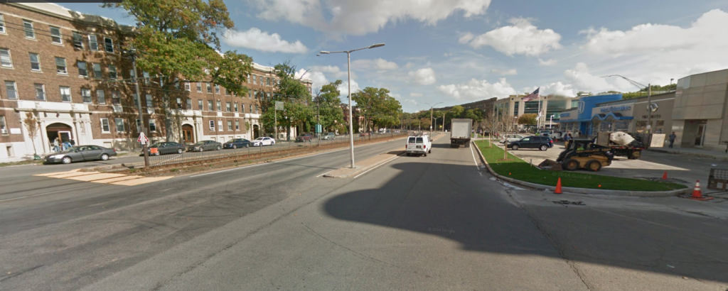
It’s time to radically rethink Comm Ave in Brighton

Welcome to the now-series “It’s time to Radically Rethink” where we take a roadway in the Boston area (or, in the future, elsewhere?) and really think about how it could function better. We go beyond a four-to-three conversion, as worthy as they may be, and think about how a 1950s-era street could be reformulated to serve 2020 and beyond. Our first street was Mass Ave north of Harvard Square. Next?

Comm Ave in Brighton.

Why Comm Ave? Because Comm Ave, at least west of Packard’s Corner, is obscenely overbuilt, an eight-lane highway masquerading as a local road. Originally planned as a grand parkway, most of the roadway today is a 150-foot-wide sea of asphalt, interrupted by narrow green islands and the MBTA reservation. The roadway has four through lanes, as well as two frontage roads with parking. If the roadway was used by 60,000 vehicles per day, this might be necessary. But the dirty little secret is that almost no one drives on Comm Ave.

Well, not no one. But very few people. The roadway has between 11,000 and 14,000 vehicles per day, with the higher vehicle counts west of Chestnut Hill Avenue. Some other roadways with similar traffic counts? Washington Street near Saint E’s, Cambridge Street near Inman Square, and Chestnut Street near Jamaica Pond. What do all of these streets have in common? They’re all two lanes wide. (Many two-lane streets are significantly busier.)

Comm Ave is six lanes wide. It’s a complete street for cars—and no one else.

It was originally designed as a Frederick Law Olmsted roadway (a comprehensive early history here), but you wouldn’t know that from the concrete expanse of the roadway today (portions were originally significantly narrower, but was widened in the 1950s). Before the Turnpike, the roadway may have gotten more use, but today it sees little more traffic than a side street. It serves a transportation purpose, but mostly for transit; twice as many people ride the B Line as use the roadway (13,000 people board west of Packards Corner, almost all inbound, so a similar number ride this segment outbound), yet the B line crawls along, stopping frequently for traffic lights and loading passengers on substandard, non-accessible platforms.

Pedestrians are forced on to often-narrow sidewalks, and experience long crossing times (and long gaps between crosswalks) when trying to get from one side to the other. And cyclists? Options for cyclists are to ride in the highway-like traffic lanes or ride the service roads along parked cars with frequent side streets. Despite being the widest street in the city, there are no provisions for cyclists.

So it’s time to radically rethink Comm Ave.

In the City of Boston’s defense, they have gotten a start, but as usual, they are thinking first about cars, and then about everyone else. Their presentation gives three reasons the city wants to maintain four main lanes (six total):

  • Operational flexibility including winter
  • More signal time available for pedestrians
  • Consistent with adjacent segments = safety
Huh? None of this makes sense. First of all, there are plenty of two-lane roads which can be operated in winter (all of them, it turns out). Second, more lanes means more for pedestrians to cross, so this makes no sense. And consistency = safety? How is a wider, faster roadway safer for the majority of users (cyclists, pedestrians and transit users)? If anything, a narrower road would allow for better transitions, and pleasing the wishes of motorists to see a consistent roadway should not get in the way of building something safe for everyone.

Here’s how it comes out:

There’s still a lot of pavement there. Yes, there’s a nice multiuse path, but there are still six lanes of traffic, and parking. And note that since the MBTA does not like trees near their right-of-way, the second-from-left tree would likely not exist. Without moving curbs—as this plan proposes—it’s nearly impossible to rebuild the T stations with full accessibility, nor does it provide a staged plan where, when the Green Line tracks are rebuilt, it can sensibly be integrated with the design.

So what if, instead, all of the current traffic on Comm Ave was shifted to the outside roadways, and the middle of the road became a two-mile-long linear park? In other words, what if you built the portion of Comm Ave west of Packards Corner to more resemble Comm Ave in the Back Bay than, say, the Mass Pike?

This wouldn’t be as hard as it seems, and it could be done in stages with the first stages allowing current traffic movements while providing better cycling and pedestrian facilities In the long term, by rebuilding and relocating the Green Line tracks (a project which the City of Boston should help the T to fund, similar to how other cities fund transit agency projects), it would allow a 75- to 100-foot-wide linear park stretching from Chestnut Hill Avenue to Packards Corner, unlocking the pockets of useless parkland and creating a wide, welcoming park.

Here’s what Comm Ave looks like today:

It’s 200 feet wide from curb to curb, yet two thirds of the spaces is devoted to cars. The two sidewalks take up 37 feet, and the T reservation another 30: beyond that it’s all travel lanes, parking lanes and medians to keep the lanes apart (and encourage faster driving). The city’s plan would mostly replicate this: a couple of improvements here and there, but mostly the same profile.

Here’s an idea of what you could have instead:

This would still allow two lanes of traffic in each direction, but rather than being a pseudo-highway in the middle of the street, cars would instead travel along the edges, and along parallel parking, to allow easy access to local businesses. (A single lane of traffic would only reduce the width of the roadway by a couple of feet, since a certain width is needed for fire apparatus, and would also allow loading zones during the annual Allston Christmas festivities.) Two lanes of traffic in each direction is plenty for this roadway, and this profile provides it. The traffic is all shunted to the side of the roadway and might move a bit more slowly, but this is a local roadway, and slower traffic would be better.

Now, this assumes the MBTA rebuilds its track, allowing a wider roadway on the north (left side of this diagram, which looks east) side. Since that’s a worthy—but longer term—project, there’s a relatively easy interim stage which can be constructed: build the final alignment of the south side (eastbound traffic) of the roadway, and leave a lane of westbound traffic to the south of the MBTA reservation. It would look something like this:

This allows for most of the beneficial elements of the roadway to be built:

  • Most of the green space
  • The curb-side cycletrack on the eastbound lane (which could be shifted to the left if there were data that showed too many turning patterns, although then it is harder to access the sidewalk and businesses)
  • The center walking path and cycling facility
But it’s also very scalable. Once the MBTA right-of-way was moved south in to the existing roadway to allow all westbound traffic to be moved to the north of the T tracks, the rest of the roadway could be filled in allowing for the final state with a wide green median between the two sides of the road.
There’s a lot more to make this street work I’m not showing here (especially on the transit side). The T stations could be rebuilt with center platforms to ease boarding and alighting, moved back from roadways to allow easier operations, fill transit priority allowing trains to proceed at speed through intersections with minor streets (i.e. every street except Harvard Ave), smooth out some of the tighter curves for the Green Line, and place the streetcar tracks in a grassy right-of-way to allow a wide green space in the middle of Comm Ave. Combined, this would speed operations by 10% or more, allowing the T to operate more service with the same number of trains.
But let’s first think a lot harder about how much pavement we actually need on Comm Ave. The city is rejiggering the current alignment. Instead, we could add several acres of parkland to the middle of Allston. We can do better.

MassDOT’s reasoning for closing Riverbend Park is a farce

If you’re going to close a park for a highway project, you better have a damn good reason for it. MassDOT’s reasoning for closing Riverbend Park this summer in Cambridge doesn’t even come close.

Here is a letter John Hawkinson obtained which MassDOT sent to the DCR asking them to keep Memorial Drive open in Cambridge for two Sundays. This letter was never made public, and at no time has MassDOT’s public traffic management plans stated that Riverbend Park would be closed. The letter does not clearly cite a threat to public safety as would be required by state law. In addition, it does not even mention any mitigation for the temporary removal of parkland to satisfy federal 4(f) regulations. None of this has been this mentioned in any MassDOT traffic management plan: the idea was to keep it quiet until the last minute.

This is unacceptable.

The letter does not remove any doubt that there was no thought given to this by MassDOT, just a reaction that more roads are always the solution. This is wrong. The third paragraph of the letter gives the rationale for requesting the removal of this park. The reasons given are:

“The approved traffic management plan requires the use of Memorial Drive as a detour route for both automobiles and MBTA buses throughout the duration of the shutdown.”

However, none of the portion of Memorial Drive used for the detour is affected by the Riverbend Park closures on Sunday. I’ve taken the liberty of adding big red arrows showing the southern extent of the Riverbend Park closure overlaid on MassDOT’s traffic management plan:

Anyone see the problem here? I sure don’t. It seems that all of the detours take place away from the area which is closed on Sundays. The only portion possibly affected would be one half of the BU Bridge southbound detour, except that is adjacent to the portion of Memorial Drive closed. The Riverbend Park closure would actually improve conditions for this portion of the detour, since cars making a left from Memorial Drive to Western Avenue would have the entire green cycle to make the turn, from both lanes, since there would be no oncoming traffic.

Yet there have been no traffic studies or traffic counts.

The “rationale” continues:

“It is important that Memorial Drive remains open to all vehicular traffic during the above requested dates to ensure the smooth, orderly and safe routing of traffic around the limits of the project.”

It is true that we need to have safe, orderly traffic! But Riverbend Park does not affect the portions of Memorial Drive affected by any traffic detour. In fact, by closing Memorial Drive, some drivers may choose to avoid the area altogether, reducing traffic in the project area and reducing congestion.

There is simply no explanation for MassDOT requesting that DCR keep Memorial Drive open, and Riverbend Park closed, during the Commonwealth Avenue Bridge project. With more construction upcoming in the area, we need to make sure that MassDOT has a very high standard for any adverse impacts to parkland. In this case, they have failed to meet such a standard.

Call your Representatives, call your Senators, and demand that Riverbend Park remain OPEN.

Update: I received a response to a call placed to MassDOT. The general process, which apparently happened behind closed doors, was as follows: someone from the “public safety” community asked that the road remain open. MassDOT, without any data or modeling (I asked if any existed and was told that it did not), decided that it was, in fact, a public safety issue, and requested that the DCR keep the roadway open. There was no public process, and the letter only cites the “smooth, orderly and safe routing of traffic,” saying nothing about emergency vehicles.

It turns out, reading the letter closely, MassDOT doesn’t even know where the park is. They request a suspension of “the ban of the use of motor vehicles on Memorial Drive between Western Avenue and Mount Auburn Street.” Yet Riverbend Park extends between Western Avenue and Gerry’s Landing Road; it runs parallel to but never intersects Mount Auburn Street. This is a small oversight, but shows how little mind was actually paid to this issue.

The staffer I spoke with mentioned that it would impact emergency vehicle access to Mount Auburn Hospital (which is not accessed from Memorial Drive) and to the LMA. If there were traffic, then emergency vehicles could use Memorial Drive by moving barricades (this could be staffed by state police traffic details) and then use the BU Bridge, which will be open to buses and emergency vehicles. But that wasn’t brought forth as an option, there was no process involved, and instead the “close the park” was put forward as a solution, one still looking for a problem.

Call to Action: Protect Riverbend Park from DCR Overreach

Since 1975, Memorial Drive in Cambridge has been closed to cars every Sunday from 11 a.m. to 7 p.m., transforming in to Riverbend Park. Originally the idea of a neighbor in Cambridge Isabella Halsted, it is one of the oldest such continual “open streets” events in the country, and it is enjoyed by thousands of residents from across the Commonwealth every week, who can have eight quiet hours to walk along the river without the constant din of automobile traffic.

Except the DCR doesn’t seem to like it. Columnists have noted in the past that they often let cars on to the road before the closure officially ends. The city has requested that the closings continue year-round, but to no avail. DCR is required to close the roadway to traffic by statute passed in 1985, but they do the bare minimum.

There is a condition in that statute, which is that:

the [DCR] may at its discretion suspend
any authorized closings, if in the judgement of said commission such
authorized closing poses a threat to public safety and should any
emergency arise in which said commission in its judgement deems it
necessary to alter the authorized closure.

This is sensible. If there were, for example, a fire along the roadway which required response, or if Soldiers Field Road was closed for repairs, we’d want the DCR to have the authority to open it to traffic. But this summer, the DCR is taking a different tack. With the closure of some lanes of the Turnpike for a construction project, MassDOT is worried that there might be some traffic in the area. They asked DCR to suspend the closure. Traffic is not a threat to public safety—if it were, Boston would be unsafe every day from 6 a.m. to 7 p.m. (longer if the Sox are in town)—but the DCR rolled over and said “sure, we’ll close it, what do we care?”

They may not care, but we do. DCR may not realize it, but this is important to many residents of Cambridge, Boston and the Commonwealth as a whole. They need to hear from us, and from our legislators. If you use Riverbend Park on Sundays—if you’ve taught your kid to ride a bike there, or walked along the river there, or ridden a Hubway there, or drawn in chalk there, or simply enjoyed the quiet along the riverbank there—it’s time to take action. Here’s how:

  1. Contact your legislator. If you don’t already know your Senator and Representative, you can find your legislator here. (Here are maps of districts, you can find a zoomed-in map of House districts here and Senate districts here). Remember to contact your own representatives first. They represent you.Here is a sample letter to write; feel free to customize it and remember to be polite, concise and specific.

    Dear Sen ___ and Rep ___,

    You may have seen a recent Globe article that the DCR plans to close Riverbend Park in Cambridge for two weekends this summer.

    This is unacceptable. Statute stipulates that DCR may only authorize such a suspension of the park if there is a “threat to public safety”. It is hard to fathom how a construction project on a separate roadway in Boston constitutes such a threat.

    Riverbend Park has been a part of Cambridge for 40 years, and I visit the park with my family every weekend to experience the riverbank without the constant drone of nearby traffic. I do not support this suspension. I would ask that you reach out to DCR and demand that they rescind this suspension immediately.

    Thank you,

    Your name
    Your address
    Your telephone/email

    Ask specifically that they follow up with you and let you know what they have found.

  2. Contact the DCR. Your state tax dollars pay for the DCR’s work. Let them know you’re unhappy. The contact for these announcements is Mark Steffen, and his email is Mark.A.Steffen@state.ma.us. Better yet, give him a call: 617-360-1715. His phone should be ringing off the hook. Contact the DCR in general as well, and remember, be firm but polite. If the DCR feels that the public is behind them, they may be more willing to change their minds. Remember, phone calls are better than emails, but both are good.
  3. Contact MassDOT. They are the ones who have made this unreasonable request in the first place. According to the project page, the best contact is James Kersten at 857-368-9041. His phone shouldn’t stop ringing on Monday, either.
  4. Contact the Governor. Again, calling is better than email. Don’t take too much of their time, but make sure to explain yourself and your position. The DCR works for the Governor. If they hear from enough of us, they might be able to make a call to turn this around. Here’s their number: 617.725.4005.
  5. If you live in Cambridge, contact the city council. You can email all of your councilors at council@cambridgema.gov. Note that the council has already asked that Riverbend Park be extended year-round, so they’re on our side, but it’s good for them to hear from their constituents about it. You can also contact the city manager to ask that he take action as well: 617-349-4300.
Obviously, wait until Monday to call. Get a message? Call again. The squeaky wheel gets the grease. It’s time to be squeaky.

Is this small potatoes compared with abhorrent policy on the federal level? Yes. But in Massachusetts, we don’t have much say beyond calling our legislators and asking they fight the good fight. As Cambridge’s own Tip O’Neill often said: all politics is local. Your voice matters. Your voice can be heard.