New York ridership-vs-distance chart

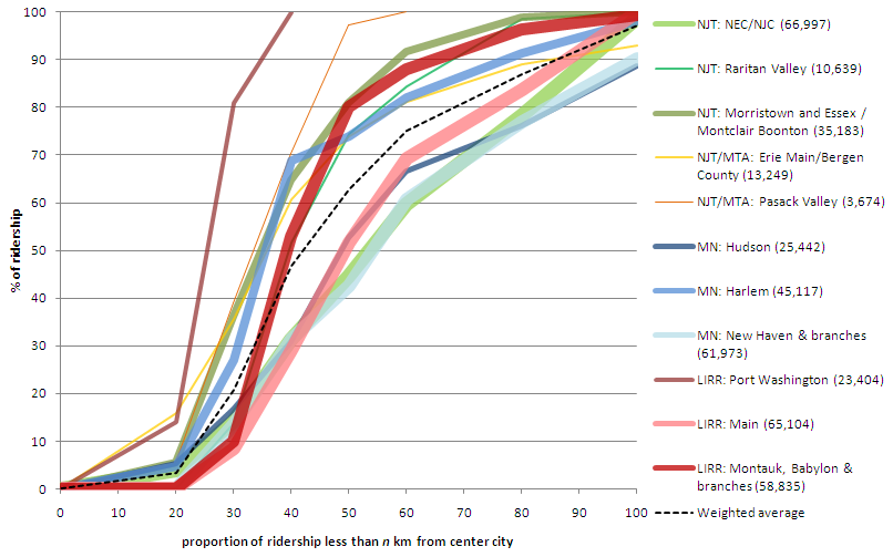
On his blog Pedestrian Observations, Alon Levy recently compared ridership on the different commuter lines in New York. It’s an interesting post, with a chart of the different lines which was begging to be thrown in to Excel and graphed. Which I’ve done:

Notes: line width is proportional to ridership. Lines are grouped by color. Green = NJT. Yellow = NJT operating in to New York. Blue = Metro North. Red = LIRR. The chart will definitely make more sense when referenced to the original post

Levy points out that lines are almost operating as separate systems: some as closely-spaced commuter rail (the group of lines more to the left) and some as almost intercity rail (the ones more to the right). In the first group, half of the ridership rides from stations between 30 and 40 km from the city center. In the second, half the ridership takes rides from at least 50 km out. What’s interesting to note is that each group has lines from each system; it’s not like the LIRR has denser lines while the Metro North has far-flung stations.

It does seem that lines which were once or are now major intercity routes are more likely to have longer-distance commuters and look more like intercity trains. The four lines in this group constitute the three main lines which operate frequent intercity service from New York (the LIRR doesn’t have any cities to operate to, of course) to Boston (New Haven), Albany (Hudson) and Philly/DC (NEC). Of course, even though the Metro North in Connecticut serves trains to Boston and Springfield, it is still painfully slow with maximum speeds of only 70 mph, half the speed of the NJT NEC towards Trenton.

Anyway, I think the chart looks pretty cool. (Next up: giving the same treatment to Boston’s trains, and whining about the MBTA’s commuter services a bit.)

Dear Mr. McGrory: stop the anti-bike/ped snark

Brian McGrory is a columnist for the Boston Globe, and someone told me he’s a good one. However, he has it out for anyone not driving their own car, I think, unless he is being very coy and sarcastic. When Hubway was launching last July, he proposed banning bikes altogether. It’s pretty tongue-in-cheek. Obviously he doesn’t want to ban bikes, but he wants cyclists to do a better job of obeying the rules. Sure, he posits that all cyclists are lycra-clad speedsters who run red lights with abandon. (We’re not.) I get the point; but there was probably a better way to say it.


But was that an isolated incident of non-driving hate? Apparently not. Today, after last year endorsing a war against bikes, McGrory rails against the war against cars. Apparently—and believe you me, I have not noticed this—Mayor Tom Menino, in declaring his support of bikes and walkers, has actually declared war on the automobile. So “the car is no longer king” is a battle cry. Right.


McGrory’s latest column is pure rubbish. It turns out Menino wants to convert some parking spaces to “pop-up parks” or “parklets.” This sent McGrory in to a rage. The mayor is crazy! he writes. And he needs to be committed.


Apparently, the lack of vehicular traffic is to blame for every problem in the Downtown Crossing area:

The car is still banned from Downtown Crossing, even while it’s painfully obvious that the hard luck neighborhood would benefit enormously from vehicular traffic. Cities around the country have turned their tired pedestrian malls back into real streets with great success.

Oh, where to begin? First of all, many of the country’s de-pedestrianized malls have been in places like Buffalo and Kalamazoo, not the most vibrant of metropolises. Pedestrian malls are going strong in cities like Denver, Burlington, Minneapolis and Boulder, and New York has cordoned off main streets in its retail core to widespread praise. Second, it’s quite possible that a lot of the issues in the area are due to a massive hole, and the mayor has been instrumental going as far as to threaten eminent domain takings (nothing says blight like an abandoned building) to speed reconstruction forwards. Third, it’s not like the retail district there is dead. While it might not hop at night, during the day the area is filled with thousands (by some counts, a quarter million) of pedestrians daily. Adding a few hundred car trips would be to the detriment of these hordes.


And it’s painfully obvious that cars along the currently-pedestrian streets would help? Apparently McGrory hasn’t ever been to Filene’s or Jordan Marsh (or Macy’s). The streets in Downtown Crossing are one-way, one-lane streets. They are busy with pedestrians, cyclists and deliveries, and trafficked streets nearby usually feature stalled vehicles waiting for lights. I’m not sure how a few extra vehicles in the area—and no on-street parking, assuredly—would be a panacea for the woes. A Wegmans or Target and 500 units of housing, on the other hand, might help.


McGrory concludes, after positing not an iota of actual data, that “the mayor is at war with the car, and the drivers are the collateral damage.” He, as we have seen, believes everyone drives, or at least, everyone ought to. I would contend that the mayor is simply fulfilling the wishes of the majority of voters who elected him. (Yes, believe it or not, Hizzoner still stands for elections.) 51% of Bostonians don’t drive to work, and only 44% drive (it was 51% ten years ago). Yet most of the real estate of our rights of way is given over to cars, even if they are a smaller fraction of the users on a stretch of road.


Maybe, Mr. McGrory, the mayor is simply acting in the best interests of his constituency. Or, at least, the constituency who has actually gotten out of their cars in the top walking city n the country. If you’d like, I’d be glad to take you on a walk and bike ride to some of the places you’d like to have teeming with cars instead of vehicles. Let me know.

I love car sharing. I just wouldn’t invest in it.

[They say that hindsight is 20/20. So I’ll preface this post with the fact that I was making this argument years ago, as in 2010, well before ZIP ever went public. (A quick search of my Gmail for Zipcar IPO did the trick.)]

Car sharing is great. It’s not applicable to every market (i.e. it works better in Boston than Houston) and in the short term, outside of dense cities with pricey parking it will be a niche product. But its users dramatically reduce the number of cars on the road, and they also reduce the amount that they drive when they pay the full cost of driving, not just the marginal cost after the static costs of insurance, depreciation and parking. From its infancy less than 15 years ago (most large city car sharing organizations—CSOs—launched between 1998 and 2002) it has grown to an almost-mainstream product with close to 10,000 cars and a million drivers in North America.

But I’m not about to invest in it. And Zipcar (ZIP), which went public last year, has promptly lost two thirds of its value.

Zipcar’s aim in an IPO was to both pay back their initial investors and raise money for expansion. However, as they expand, they are not going to be able to exploit economies of scale in the way many growing companies can. They have entered their best markets, and further expansion will be in to markets with lower margins and which require more marketing and long term demographic change (Atlanta instead of Boston). The heady days of the early ’90s, when car sharing organizations in dense cities threw cars on to the streets as fast as they could, have come to a close. The top neighborhoods are well-served. Future expansion will be slow and methodical, and not particularly profitable.

In fact, several successful car sharing organizations don’t really ever intend to turn a profit. The following are major car sharing organizations in the US and Canada:

  • Zipcar, for-profit start-up, founded 2000 in Boston, main vendor in Boston, New York, DC, Portland and Seattle, with a presence in all large markets except Montreal. Bought Flexcar (for-profit) in 2007; Flexcar had originally been formed as a public-private partnership in Seattle in 2000, and bought a Portland-based not-for-profit (Car Sharing Portland) in 2002 before expanding and being bought by Zipcar, apparently close to bankruptcy.
  • Hertz on Demand, for-profit spinoff of car rental agency, founded 2008, New York
  • Mint, for-profit spinoff of parking garage manager, founded 2008, New York
  • City CarShare, independent not-for-profit, founded 2000 in San Francisco (for a couple of years, San Francisco had competition between CCS, Zipcar and Flexcar)
  • I-Go, not-for-profit division of a larger organization, founded 2002, Chicago
  • PhillyCarShare, not-for-profit start-up in 2002 sold to Enterprise in 2011
  • CommunAuto, for-profit start-up in Montreal in 1994
  • Autoshare, for-profit start-up in Toronto, 1998
  • Modo, founded as The Car Coop, cooperative founded in Vancouver in 2000
  • Most smaller CSOs are non-profits (HOURCAR, Ego, Ithaca Carshare, Carshare VT) with a few for-profits (CommunityCar, OccasionalCar) and coops as well.
Interestingly, every city with even a medium-sized car sharing scheme, except New York and Washington D.C., has had, at one point, it’s own homegrown car sharing service. Zipcar only succeeded in using it’s size to run Flexcar in to merging (and this may have been more due to management policies on Flexcar’s part) and PhillyCarShare to a sale (again, quite possibly due to management issues). Washington, D.C. is the only city in which competition has markedly decreased (it and San Francisco had Zipcar-Flexcar competition before that merger; San Francisco retains competition with CityCarShare); the rest of the markets Zipcar has entered it has failed to dislodge the existing player in town. (That being said, with the exception of New York no one has entered a Zipcar market after they had established a presence.)
But look at how the major players were founded:
  • 4 as for-profit start-ups
  • 2 as other for-profits (Both in the New York market)
  • 4 as not-for-profits
  • 1 as a coop
About half of the players in car sharing started off as non-profits, and two (I-Go and CityCarShare) remain non-profit today. I’d be reticent to invest in a business model where nearly half of the original founders didn’t see the opportunity or necessity for profits.

There are three main issues which will keep car sharing from ever being a terribly profitable business. (Yes, it likely will achieve a steady level of profitability in some markets and may pay small returns to investors, but won’t grow dramatically.) One is the issue of car sharing being a capital-intensive business. The second is that, charging by time, CSOs are hamstrung by there being only 24 hours in a day. Finally, for both mission and practical reasons, car sharing organizations are one of very few businesses which often actively encourage their customers to use their product as little as possible. None of these helps the bottom line.

As far as capital goes, car sharing is expensive. CSOs have to buy (generally) new cars, install a couple thousand dollars of hardware, and continually maintain them. Unlike rental car companies, which can sell their fleet seasonally or to adjust to market conditions, CSOs decal their vehicles and install locking mechanisms, relays and mileage tracking devices. These investments raise the barrier to selling capital quickly, and most CSOs keep their vehicles for several years, not several months. Having a lot of capital tied up in depreciating assets encourages stability and slow growth, but not necessarily high profits.

With millions of dollars of capital tied up in vehicles, car sharing organizations are hamstrung by the number 24: the number of hours in a day. This, however, is misleading, because very little car sharing takes place overnight, when many CSOs have reduced rates. In addition, most car sharing organizations have daily rates, which allow consumers to cap the cost of a shared car at around the cost of an 8 hour rental, but this also caps the potential revenue at 8 hours. Since car sharing breaks even with between 5 and 6 hours of use per day, this leaves a small margin for profitability. And even without daily rates, customers become agitated when availability dips, generally around 9 hours a day (50%, assuming the hours of 12 to 6 a.m. rarely see car usage).

Is there room for profitability between the break-even point and the daily rate barrier? Yes, but not much. Usage is lower on weekdays, and if cars saw maximum profitability on weekdays they’d be swamped on weekends. Thus, most CSOs have higher rates on weekends (this is what we call supply and demand). And since the fixed costs of buying, parking and insuring a vehicle is quite high, there is little room to reduce the break-even point. Some cars in high-use areas will always profit, but a CSO will generally have fringe cars in neighborhoods which see less use (but absorb extra demand and expand the geographical market). And cars which do very well in the summer often see usage decline in the winter, but with annual parking space contracts and investments, CSOs can’t change their fleet size based on the season. So making a profit in car sharing is akin to threading the needle of a balance sheet.

Finally, once a member joins a car sharing organization, they aren’t generally encouraged to drive as much as possible. For one thing, some members might find that, by driving a lot, they would be financially better off buying a car, depriving a CSO of a highly-valued member. In addition, non-profit CSOs, and many of their for-profit brethren, are motivated by environmental goals, and find it hard to encourage their members to “drive as much as you can!” So car sharing is one of very few businesses where a consumer is told to buy a product and then use it as little as possible. (Imagine, for instance, McDonalds running ads saying “cheeseburgers are a great alternative to eating at home, but really you should eat our cheeseburgers only when you’re really in a pinch for time.”) CSOs will encourage their members to use the cars, but have to tread a very fine rhetorical line to encourage “exploration” and “new experiences” rather than just driving more.

Put these together, and car sharing is a maturing service which will continue to grow. However, it’s not something that’s ever going to turn a huge profit.

On the other end of the spectrum, current investors, like the esteemed (at least, when he’s getting yelled at by Jon Stewart) Jim Cramer, also have things wrong. They argue against buying Zipcar shares because they fear big car rental agencies are going to push in to Zipcar’s turf and take over its business. If this was the case, it would have happened by now. But car rental agencies have a different business model, and they’re not about to change their stable, successful businesses to jump in to something new, and something which barely makes money.


In other words, Hertz is not about to move their airport-based fleet of rental cars in to the middle of the city and take over Zipcar’s business. Their business model is to buy new cars, drive them for 25,000 miles, park them in big lots at an airport, and sell them within a year. They operate with very low overhead, comparatively few locations, and, outside of airports, limited hours. Some have made feints in to the car sharing market from static locations with limited pick-up times and key boxes; these have been unsuccessful. The only money they put in to their cars are 25¢ key rings, so they can sell off capital at a moment’s notice. They don’t have to invest in parking spaces, signs and space leasing agreements. They play the car market, and, from time to time they rent them out.


The one opportunity for car rental agencies is that the demand for rental cars and shared cars is flipped. Rental cars see low use on weekends, shared cars see low use on weekdays. If Hertz could magically move half their fleet from the airport to the city every Friday and back on Sunday night, they’d have something going. This, however, would mean driving their cars at high revenue and high traffic times, from one central location to dispersed spaces in residential areas. They’d have to install car sharing hardware which would only be used a few days a week, disable and reenable it to meet the whims of the rental car market, and convince traditional renters to drive a moving billboard. The logistical and personnel cost to do this would negate any potential savings. 


There are also reverse opportunities for car sharing organizations: encouraging travelers to rent shared cars during the week—especially in cities with good transit links to airports. Imagine, for example, a business traveler going to the East Bay from SFO. She could get on the BART and ride it through San Francisco and under the Bay, avoid the usual traffic on the bridge and 101, and pick up a car in Berkeley from near a BART station. By the time a traveler bound for a location west of Boston was at the desk after a rental car shuttle trip at Logan, they could take the Silver Line to the Seaport, grab a Zipcar, and jump on the Pike. If anything, I think there’s more of a market for traditional car renters to use shared cars than the other way around, especially as business travelers become more likely to be city-adept car sharing members and less likely to own a car. (Plus, from an expense-reporting standpoint, it’s easier to expense one item, a rental car, than a rental car and gas purchases.) But for the most part I expect car sharing and car rental to remain separate business segments as this would only be feasible in markets with sizable car sharing markets, good airport transit and cross-city reciprocity (right now, only Zipcar).


So, car sharing will continue to be successful, but never wildly profitable. If shares were to fall far enough and Zipcar shows continued profitability, I could see it being a decent investment, but not one that would ever run up Apple- or Google-like returns. For now, I’m staying away.
Hubway Helmet Storage

I’ve been riding Hubway a lot this summer and enjoyed it’s convenience immensely (I’m at 54 trips and counting since April).

One of the issues with bike sharing, however, is helmet use. The point of bike sharing is that you can pick up and drop off a bicycle like you would get on a bus or hail a cab. To a lot of users, having to carry around a helmet is antithetical to these goals. Attempts to solve this abound: Boston sells subsidized helmets across the city (I know; I bought one in a pinch and it currently serves as my “office helmet” which I’ve offered to share with coworkers). DC does too (but they cost a bit more). Melbourne, which has mandatory helmet use, has seen its system struggle, and sells helmets for just $5, which you can return for a $3 rebate. Minneapolis is straight giving away 10,000 bright green branded helmets. Vancouver considered shipping Montreal’s mothballed Bixi system from winter storage out for the Olympics but was stymied by their province’s helmet law. The city still doesn’t have a bike sharing system.

And there’s the cool MIT helmet vending machine. Really cool. And, uh, not in production yet.

Still, all of these ideas are for origin helmet dispensing? What about those of us who have a helmet already?

Riding a clunky, heavy, stable bike for a mile in the city is not prime helmet use territory, and many casual users don’t use a helmet. For those of us who do (perhaps because of prior experience), Hubway becomes an exercise in always having a helmet handy. More than once I’ve been ready to get off the Red Line at Charles (Side note: this station earns a 4.5 star rating on Yelp.) for the four minute jaunt down Charles Street only to realize I’d left my helmet at home and jumped back on the train.

But I’ve gotten better. I almost always have a helmet with me when I want to start a trip. Helmet availability is less and less of an issue. The problem is: what do I do with my helmet when I get to my destination?

I could strap it to my belt or put it in a bag. In my line of work and the circles I travel, wandering around with a helmet is, if not a badge of honor, at least somewhat acceptable. Luckily, on Hubway, it usually stays relatively non-sweaty. But in a crowded bar, having a helmet clipped to your belt looks really dorky, and can get in the way. It’s awkward to say “excuse me” and have a helmet rub up against someone’s thigh. (But maybe it’s a good way to break the ice with the cute cyclist across the room. I digress.) Or, I ride Hubway to the train station, and then wind up taking the train, walking to a meeting, going to the meeting, walking back to the train and riding back to the city, all the while toting my helmet. It doesn’t keep me from riding Hubway, but it’s a nuisance.

So what I think bike sharing needs is helmet storage at racks. More than once I’ve considered not taking Hubway simply because I didn’t want to have to keep track of my helmet while at my destination. (I’ve never actually found an alternative, because Hubway is really damn convenient.) Here’s are a couple scenarios to consider:

  • I leave my office after work and bike a mile across town to meet a friend at a bar. I store my helmet at the bike rack, and when I come back, I grab it and bike to the T, which I take home. With my helmet.
  • I Hubway over to North Station in the morning to take a train to a meeting. I store my helmet at the station. Back a few hours later, I fetch my helmet from the helmet storage, pop it on my noggin, and ride back to the office.
So what I think Hubway needs is helmet racks. Generally, people don’t steal helmets. If you lock your bike and hang the helmet off the handlebars, it will be there when you get back. The front wheel might be gone, but not the helmet. No one steals helmets to resell because no one buys used helmets (because you have no way to know if it’s been in a crash, and it’s all sweaty, too). No one steals helmets to use them because of the aforementioned safety issue and, well, because the population that is in to wearing helmets is generally not that in to petty larceny. I’ve left a helmet unlocked myriad times and it’s always been there later on. And, also, someone else’s sweaty hair. Ew. So no one steals helmets. Except …
Except near a bike share. It’s the only place where helmetless people would think of grabbing a helmet and going. It wouldn’t be their intention to steal it, but to use it and drop it off somewhere else. Which would work great, unless someone else was counting on coming back and finding it there. If you were at a bike share station and saw a helmet just sitting there, would you take it? Quite possibly you would. Even if it quite possibly belonged to someone else. And if there were just helmets clipped to a fence near the rack, they might be seen as a public nuisance and removed and trashed before their users could fetch them. So we need a rack with some sort of security.
The design could take any number of forms. The main hurdle of access can easily be solved by limiting access to people carrying an RFID chip with a unique code, which, very conveniently, is how bike sharing users access the bikes. (Except, of course, for daily users, but they’d be less likely to have their own helmets to store and make up a small portion of the user base. Plus, they could integrate the passcode system in the helmet storage.) It could be a stack of cages with doors which could be accessed by presenting a Hubway key. It could be a set of small U-locks which could be removed, put through a helmet vent (or even strap: cutting a strap to steal a helmet renders the helmet useless) and replaced. It could even be cables which would go through helmet vents or straps. 
Time limits could be enforced: after, say, six hours the user could be charged, or the cage could simply unlock. Rarely am I somewhere for long before I come back to the rack, grab a bike (and my helmet) and go. And it could easily be integrated in to the MIT HelmetHub design. Time to give them a shout, it seems like it would be compatible.
High security would certainly not be needed. No one is going to walk around with garden shears clipping locks and stealing helmets (for the same reason no one grabs helmets off the street; see above). The issue would be keeping the helmets safe from casual, almost accidental thief (“I need a helmet. Hey, look a helmet!”) and providing infrastructure which would say “helmets belong here, don’t mess with ’em.”
I know I’d use this system. I’m not sure how many others would. However, I think the market is there. Whether it’s someone who is already using the system and would wear a helmet if she had somewhere to store it, or someone who is interested in the system but doesn’t use it because they need somewhere to store their helmet. Either way, helmet and system use would rise. Neither of which is a bad thing.
This doesn’t solve the problem. But I think it’s a piece of the puzzle.

Apparently the WSJ hasn’t heard of slugging

The Wall Street Journal (or, according to Wonkette, the WSJ banking pamphlet) has an article about people who pull over to bus stops to pick up passengers before crossing the George Washington Bridge, saving tolls. They mention carpool savings in San Francisco but miss a bigger point: this is exactly how slugging started in DC, three decades ago!

According to Wikipedia:

The term slug (used as both a noun and a verb) came from bus drivers who had to determine if there were genuine passengers at their stop or just people wanting a free lift, in the same way that they look out for fake coins—or “slugs“—being thrown into the fare-collection box.

The original sluggers would poach riders from bus stops. After a while, slugging queues formed at park-and-rides (on the inbound) and areas with many offices like the Pentagon (on the outbound) and the system became self-reinforcing. Sluggers have an unofficial website now and the system has been around long enough that it is ingrained in a couple of areas. However, one of them may not be New York.

Emily Badger, now of The Atlantic Cities, wrote a long and interesting piece about slugging last year, which outlined several factors that have to be in place for slugging to work:

  • The HOV requirement must be 3. HOV-4 is too cramped, and HOV-2 lacks a sense of security. (With three strangers in a car, even if one is crazy they’ll be outnumbered.)
  • The HOV lane has to be lengthy or have a high toll, and paralleling traffic has to be bad enough that it saves considerable time. In DC, the 95/395 corridor is one of the most gridlocked in the country, while the carpool lane sails along at freeway speeds. And misuse must be enforced.
  • There needs to be a parallel transit system for backup, even if it is slower. Drivers and passengers will not always balance perfectly.
  • Employment needs to be situated in dense urban nodes that draw workers from a highway corridor
  • Some homogeneity in the workforce. For instance, everyone in DC works for Uncle Sam (or so it seems)
I would add that slugging also needs
  • The existence of park-and-ride lots where riders can congregate (preferably with some amount of cover from the elements)
  • Parallel transit can’t be too fast, frequent or reliable, although it’s rare to find fast, reliable and frequent transit in the US. (In other words, if there was a Metro Line along 395 which ran at 110 mph to the District, there would probably be fewer slugs. But since the transit options are a bus with a transfer to Metro, slugging is faster.)
  • The end of the system has to be in a transit-served area; the transit, or even bike sharing, can provide a last mile solution from the slug lines (which are sort of like transit stations).
On the GW, high tolls are certainly in place, and there are savings to be realized with an HOV toll pass. However, the system lacks a few other features. There is no major employment density on the other side of the bridge. Well, there is, but not that many New Jerseyites drive there from the GW. There are no time savings for HOV travelers, either. There’s nowhere to congregate (although this might change, according to the article). Once across the bridge, there is relatively easy access to a subway station, but getting back on the highway requires a couple of zigs and zags on surface streets to the Bronx. Once on the train, however, the A train runs express to Midtown, making the trip in 20 minutes, which is generally faster than driving. Also, there is no toll westbound, so there’s no incentive to pick up a passenger and save.
What would it take for slugging to catch on on the GW? First, the police would have to stop ticketing people for picking up slugs. It would have to be a two-way system, which would require more tolling capacity. A dedicated, easy-on, easy-off slug facility or location would have to be found (in Manhattan, this could be a section of street, but it’s harder on the interstate in Jersey). And to cap it off, I think the Port Authority would have to create free-flowing carpool lanes, to create a time incentive. This, too, would be tricky, because they’d have to extend across the Palisades (which often back up), but in doing so would extend beyond the market of available slugs. So, the GW might not be right for slugging.

Road Width vs Road use

When I was researching information about the new green housing development in Brighton I found some interesting numbers regarding the traffic on Commonwealth Avenue. As part of their permitting with the Boston Redevelopment Agency, a big PDF details the traffic patterns in the neighborhood, for both pedestrians and vehicles. Looking at the traffic numbers, I got the feeling that Commonwealth Avenue in Brighton is not equitably sized. In other words: the width of the road is not proportional to the number of users for each segment.

Here’s how the roadway in question breaks down (I measured it online):

The unlabeled gray sections are medians. Here it is simplified by use:

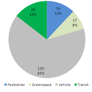
And here’s a pie chart of how many feet (the total width is 200 feet) are used for each use:

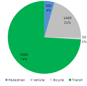
About two thirds of the street is taken up by traffic lanes, parking or medians which separate traffic lanes and parking (and provide no refuge to pedestrians and no landscaping). But of people traveling along Comm Av, fewer than two thirds are traveling by car. Many fewer. According to the study, there are, at the peak PM rush hour between 5 and 6 p.m., 1343 vehicles traveling along Commonwealth or turning on to or off of Harvard. Of these, 785 go through, and the rest turn. Counting each turner as half a trip, there are 1064 road users along this stretch of Commonwealth Avenue. Assuming some carpooling, this probably equates to about 1400 people per hour.

There was no count for cyclists. This is a frequented stretch of road by bikes, but it is certainly not bike-friendly. I’d guess that there are 50 bikes per hour in total at rush hour. (There are no marked lanes for cyclists and they have to choose between the trafficked main travel lanes or the carriage/parking lanes which have parked car hazards and more stop signs. Most choose the former.)

For pedestrians the counting is easier: there are about 300 walkers per hour.

As for transit users: the T maintains a six-minute headway along this stretch of street during rush hours. In recent years, they’ve moved from two-car trains to three-car trains, and about half the rush-hour consists along this line have three cars. That’s 25 vehicles per hour in each direction. In the peak direction, the T operates at or near crush capacity in this section, with 150 to 200 passengers per car (specs here). The non-peak direction probably operates at about one third that capacity, with 50 passengers per car (around all-seated capacity). This estimate gives us, conservatively, 5000 people per hour.

So, compare the chart above to this one:

The vehicle right-of-way, which uses the lion’s share of the street’s real estate, sees fewer than a quarter of the street’s users. Transit, with less than a sixth of the street width, carries more than triple that number. Per linear foot, the roadway and the sidewalk come out about the same. By passengers per foot of right-of-way per hour (ppfph) the numbers break down as:

  • Vehicle ROW: 11.1
  • Sidewalk: 12.5
  • Transit: 172.0

Note where the decimal is for the transit. It’s 15 times more efficient for each unit of real estate.

This can be documented for many other streets. Take the main cross street here, Harvard Street. It sees about 900 cars (1200 passengers) at peak hour, 350 pedestrians and (I’m guessing here) 60 cyclists (it was not counted in the bike count database since 1976). The street right-of-way is 78 feet wide, with 22 feet of sidewalk, 10 of bike lane and 46 for vehicles (travel and parking). Of course, the MBTA’s route 66 bus runs every 9 minutes at crush capacity (60 passengers per bus) in both directions, carrying about 800 passengers.

On Harvard, the sidewalks carry 15.9 pedestrians per foot per hour, the bike lanes 6 and the vehicle lanes 43.5. (Not terribly surprisingly, Harvard Street is usually gridlocked between 5 and 6 p.m.) This neglects to account for the efficiency of the buses. Buses demand some real estate, namely a 10-foot-by-50-foot bus stop every 1000 feet or so. That breaks down to one half of one linear foot, but for good measure we’ll assume the buses use that much street real estate during travel, and assign two of the vehicle feet to the buses. That changes the numbers:

  • Vehicle ROW: 27.3
  • Bike lanes: 6.0
  • Sidewalk: 15.9
  • Transit: 400
Does that mean that the 66 bus is more efficient than the Green Line? Certainly not. With 800 passengers per hour, the 66 is stretched to capacity: it gets bogged down in traffic, it frequently runs late or in bunches, and it crawls along its route. To add many more passengers, it would need its own lane. Even still, if, as a bus rapid transit, it took over the parking lanes (note: this won’t happen any time soon) and doubled its ridership (likely, considering how many people take it even despite its slothly pace, it would still be more efficient than the adjacent roadway.
(And one more note: we’ll look at the Red Line on the Longfellow Bridge soon, but the back of the envelope calculation is 15 trains each way carrying an average of 750 passengers each per hour in 30 feet of right of way, giving a ppfph of 750. A New York Subway line running every three minutes with 1000 passengers per train would yield a ppfph of 1333. A highway at peak capacity might be able to attain 2700 passengers per lane per mile—or a bit more with a lot of buses—for a ppfph of 225, but adding any more vehicles quickly decreases the speed and capacity.)

Naming housing developments

I have an interest in the names that developers give to houses, especially in cities. For instance, older apartment buildings along Beacon Street in Brookline are often named (here’s one: the Metropole) as are newer developments. I plan to explore these further.

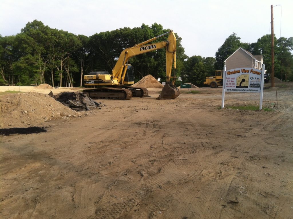
But I was biking in Woburn, not way out in the suburbs, but out there, and had to stop and take a picture of a new subdivision going in:

Meadow View Farms. That’s interesting, because as far as I can tell, there is no meadow, there is no view, and there is certainly not a farm. And the web address (the site shows a flowing field of wheat—which we don’t even have in the northeast!) includes estates—there aren’t any of those either. Just McMansions.

Not the worst kind of development in Allston

The Boston Globe ran a piece recently about a “green” development in Brighton Allston. The part of Allston it’s in, near the base of Corey Hill, is generally thought of as the epicenter of cheap student housing in Boston: glorified (or not-that-glorified) tenements for $500 a room. A big developer got some nice press for their green housing development, and I began to cringe when I thought of the green-washing possibilities: the token solar panels and patch of grass on the roof paired with a guarantee of free parking with every unit! The thrown-together rain garden to drain the massive surface parking out back. The eminent-domained two family houses razed for a new building with a lower overall FAR and units per acre.

So I was pleasantly surprised when I found out that the development was, overall, not an overall detriment to the area. It’s scale is fitting with the neighborhood—four stories is de rigeur for that area. It has parking, but the variance is stepped down and spaces cost $165 to $200 per month, market rate for the area and 10% or more of the building’s rent (and they’re not bundled). This is my biggest peeve with so-called green projects: they are frequently either built in areas without transportation choices (this one is in a walkable, bikeable and transit-able neighborhood, even if it is on the B line) or, if they are, they either choose or are forced by their lenders to overbuild parking, which they then give away. Even at one space per unit, I think parking is overbuilt in this case. But at least in the case of “The Edge” (warning: big PDF) some of it is outside, and if it doesn’t sell it could be surreptitiously converted to open space.

Here’s the Globe’s map of the development. And a block-scale greening might just be a good investment for the developer, too.

There are other decent green features, at The Element (yes, these are stupid names, and yes there is a blog post about building names to be written), for instance. Like individual water meters: no more long hot showers for your $500 a month. (Can I complain? No, the landlord in my 1885-era house pays to water our garden.) And white roof and rooftop vegetable garden (a great amenity!). And a bunch of other garden variety green cues.

What is this housing replacing? Garages, abandoned light industry and parking. While losing the industrial buildings is sort of a shame, this neighborhood will probably never again have small-scale manufacturing. The project will build or rehab several hundred apartments for a price tag of $125 million, not a bad shot in the arm for the local economy. And since it’s on a streetcar line and a stone’s throw from Harvard Street, it’s a perfectly good place for even higher-density residential.

The site for the Edge is about 200′ by 175′, or about 4/5 acres, with 79 units—about 100 units per acre. With 1.75 people per unit, this is more than 100,000 people per square mile (more than the actual density, since it doesn’t account for nearby infrastructure). It’s not as dense as the grove of three-deckers I lived in on Harvard Ave in Brookline (almost double the density), but it’s not bad. These Allston census tracts clock in at 40,000 to 50,000 people per square mile—some of the densest in Boston (12,000 overall) and nearly as dense as Manhattan (66,000), so it’s about right for the neighborhood.

One qualm I have with most of this new development is that it lacks character, and from the pictures, this seems to be the case. Apparently everyone wants a sleek, modern granite kitchen and bare, white walls. I still think there’s a market for new 1920s-style apartments with accents like built-in pantries and wooden molding, but maybe I’m a crotchety old man who needs his scotch. Who know, maybe people love having everything sleek and white—I understand the ethic but think that it is overused.

And yes, it’s expensive. But every new unit of housing on the market should, if economics tells us anything, bring down prices for everyone (or allow more people to access the market). Economics—supply and demand—tells us that; prices are high in walkable neighborhoods because there is more demand than supply. There’s an ongoing, and well-founded, worry that new development will continue to marginalize low income populations. However, I think that it is more problematic when NIMBYs strike down denser housing because it is “out of character”, constricting supply and driving prices higher. Next: we need sustainable housing for low income residents.