Bus yards vs TOD: where is the best place to store buses?

Boston has a bus problem. Beyond narrow, congested roads and
routes which traverse several jurisdictions—in some cases half a dozen in the
span of a single mile—there are simply not
enough buses to go around
. At rush hour, some MBTA bus routes only have
service every 20 to 30 minutes, despite crush-capacity loads on the vehicles
serving them. To add significantly more service would require the MBTA to add
additional buses to the fleet, but procurement of new vehicles is not the rate-limiting
factor. The larger issue is that the MBTA’s bus storage facilities are
undersized and oversubscribed, so adding new buses would require adding
additional storage capacity to the system, a high marginal capital cost for any
increase in service.

Before doing this, the MBTA may be able to squeeze some
marginal efficiency from the system. All-door boarding would reduce dwell
times, speeding buses along the routes. Cities and towns are working with the agency to
add queue jumps, bus lanes and signal priority, steps which will allow the
current fleet to make more trips over the course of the day. Running more
overnight service would mean that some number of buses would be on the road at
all times of the day and night, reducing the need to store those buses during
those times (although they might need to be serviced during peak hours, and may
not be available for peak service). Still, all of this amounts to nibbling
around the edges. Improving bus service may result in increased patronage, and
any additional capacity wrung out of the system could easily be overrun by new
passengers. The MBTA’s bus system is, in essence, a zero-sum game: to add any
significant capacity, the system has to move resources from one route to
another: to rob Peter to pay Paul.

Furthermore, Boston’s bus garages are
antiquated. In the Twin Cities—a cold-weather city where a similarly-sized bus
fleet provides half as many trips as Boston (although about the same number of
passenger miles)—nearly every bus garage is fully-enclosed, so buses don’t sit
outside during cold snaps and blizzards as they do in Boston. Every facility
there has been built since 1980, while several of the MBTA’s bus yards date to
the 1930s; some were originally built for streetcars. Boston
desperately needs expanded bus facilities, but it also needs new bus garages:
the facilities in Lynn, Fellsway and Quincy are in poor condition, and the
Arborway yard is a temporary facility with very little enclosed area.

However, what Boston’s bus yards lack in size or youth they
make up for in location. The MBTA bus system is unique in the country in that there is no bus service through downtown: nearly every trip to the city requires a transfer from a
surface line to a rapid transit line. In the past, elaborate transfer stations
were built to facilitate these transfers, with streetcar and bus ramps above
and below street level (a few vestiges of this system are still in use, most
notably the bus tunnel at Harvard), with bus routes radiating out from these
transfer stations. When the Boston Elevated Railway, the predecessor to
the MBTA, needed to build a streetcar yard, they generally built it adjacent to
a transfer station, and thus adjacent to as many bus routes as possible. Many
of these have become today’s bus yards, and the MBTA has some of the lowest
deadhead (out of revenue service) mileage to and from the starts of its routes.

From a purely operational standpoint, this makes sense: the
buses are stored close to where they are needed. But from an economic
standpoint, it means that the T’s buses occupy prime real estate. Unlike rail
yards, which need to be located adjacent to the lines they serve, bus yards can
be located further away. While this introduces increased deadhead costs to get
the buses from the yard to the route, it frees up valuable land for different
uses. In recent decades, the T has sold off some of its bus garages, most
notably the Bartlett Yard near Dudley and the Bennett Yard near Harvard Square,
which now houses the Kennedy School. The downside is that the T currently has
no spare capacity at its current yards, and needs to rebuild or replace its
oldest facilities.

While the agency has no concrete plans, current ideas
circulate around using park-and-ride lots adjacent to rail stations for bus
storage, including at sites
adjacent to the Riverside and Wellington stations. The agency owns these
parcels, and the parking can easily be accommodated in a nearby garage. The
issue: these parcels are prime real estate for transit oriented development,
and putting bus garages next to transit stations is not the best use of the
land. Riverside
has plans in place, and Wellington’s parking lot sits across Station Landing, which has
hundreds of transit-accessible apartments.

In addition to what is, in a sense, a housing
problem for buses, the Boston area has an acute housing problem for people. The
region’s largest bus yards are adjacent to Forest Hills, Broadway and Sullivan
Square: three transit stations with easy downtown connections. These issues are
not unrelated: there are few large parcels available for housing or transit
storage (or, really, for any other use). If the region devotes land to housing,
it may not have the ability to accommodate the transit vehicles needed to serve
the housing (without devolving the region in to further gridlock). If it uses
transit-accessible land for storing buses, it gives up land which could be used
for dense, transit-accessible housing. What the transit agency needs are sites
suitable for building bus depots, on publicly-owned land, and which would not
otherwise have a high-level use for housing.

Consider a bus maintenance facility: it is really something
no one wants in their back yard. And unlike normal NIMBYism, there actually
some good reasons for this: bus yards are noisy, have light pollution, and
operate at all times of day, but are especially busy for early morning
operations. An optimal site for a bus yard would be away from residences, near
highways (so the buses can quickly get to their routes), preferably near the
outer ends of many routes, and not on land which could otherwise be used for
transit-oriented development. It would also avoid greenfield sites, and
preferably avoid sites which are very near sea level, although if necessary
buses can be stored elsewhere during predicted seawater flood events.

The MBTA is in luck. An accident of history may provide
Boston with several locations desirable for bus garages, and little else. While
most sites near highways don’t have enough space for bus yards, when the regional
highway system was canceled
in the early 1970s, several interchanges had
been partially constructed, but were no longer needed. While portions of the
neighborhoods cleared for highways have been, or could be, repurposed in to
developable land, the “infields” of highway ramps is not generally ripe for
development. Yet they’re owned by the state, currently unused, convenient to highways
and unlikely to be used for any other purpose. For many bus routes, moving to
these locations would have a minimal effect on operation costs—deadhead pull-in
and pull-out time—and the land will otherwise go unused. Land near transit
stations is valuable. Land near highways is not.

Building bus yards in these locations would allow the T to
add vehicles to the fleet while potentially closing some of its oldest,
least-efficient bus yards, replacing them with modern facilities. They wouldn’t
serve all routes, since many routes would still be optimally served by
closer-in yards with shorter deadhead movements to get the buses to the start
of the route. (To take this to an extreme: it would be very cheap to build a
bus yard at, say, the former Fort Devens site, but any savings would be gobbled
up by increased overhead getting the buses 35 miles to Boston.) Highway ramps
are optimal because it allows buses to quickly access the start and end of
routes, many of which, by history and happenstance, are near the highways
anyway.

Most importantly: moving buses to these locations would enhance
opportunities for additional housing, not preclude it. Building thousands of
new housing units adjacent to transit stations pays dividends several times
over. It increases local tax revenues and also creates new, fare-paying transit
riders without the need to build any new transit infrastructure. Finally, by
allowing more people to use transit for their commutes, it reduces the growth
of congestion, allowing people driving—and people riding transit—to move more
efficiently.

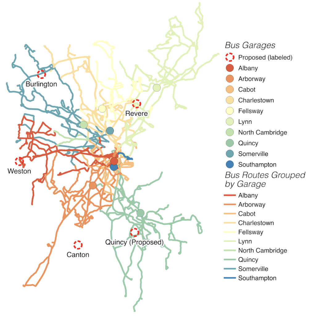
Specifically, there are five highway sites in the region
which could be repurposed for bus fleet facilities:

  • Quincy, in between the legs of the
    Braintree Split
  • Canton, on the aborted ramps of
    the Southwest Expressway
  • Weston, where the new all-electric
    tolling has allowed for streamlined land use
  • Burlington, in the land originally
    planned for the Route 3 cloverleaf
  • Revere, in the circle where the
    Northeast Expressway was originally planned to branch off of Route 1 through
    the Rumney Marshes.

In more detail, with buses counts from the MBTA’s 2014
Blue Book
. These are in-service buses required, so the total number of buses
at each location, accounting for spares, would be 15 to 20 percent higher. The
system currently maintains approximately
1000 buses
.

Quincy (67 buses)

All 200-series Quincy Routes

The current Quincy garage serves the
200-series routes, with a peak demand for 67 vehicles. The current garage is in
need of replacement. The current yard takes up 120,000 square feet on Hancock
Street, half a mile from Quincy Center station. This could easily be
accommodated within or adjacent to the Braintree Split, with minimal changes to
pull-out routes. Serving additional routes would be difficult, since the
nearest routes run out of Ashmont, and pull-out buses would encounter rush hour
traffic, creating a longer trip than from the current Cabot yard.

Canton (35
buses)

Routes
24, 32, 33, 34, 34E, 35, 36, 37, 40

This would be a smaller yard and would
probably only operate during weekdays with minimal heavy maintenance
facilities, but would reduce the overall number of buses requiring storage
elsewhere.

Weston (71 buses)

Routes 52, 57, 59, 60, 64, 70/70A, all
500-series express bus routes.

With the recent conversion to all-electronic
tolling on the Turnpike and different ramp layout, the land is newly-freed,
plentiful, and many buses serving this area have long pull-out routes from
Boston. The portion between the two branches of the Turnpike and east of the
128-to-Turnpike ramp is 500,000 square feet, the same size as the Arborway
Yard, and there’s additional room within the rest of the interchange. Without a
bus yard west of Boston, any route extending west or northwest would benefit
from this yard.

Burlington (50 buses)

Routes 62, 67, 76, 77, 78, 79, 134, 350, 351,
352, 354

These routes utilize serve the northwest
suburbs, but most are served by the Charleston and Bennett divisions in
Somerville. Most routes would have significantly shorter pull-outs.

Revere (157 buses)

The two oldest bus garages north of Boston are
Lynn and Fellsway, which account for a total of 125 buses and about 200,000
square feet. They are both centrally-located to the bus network, so moving
buses to the 128 corridor would result in longer pull-outs, except for a few
routes noted above. However, the circle where Route 1 turns northeast and the
Northeast Expressway was originally planned and graded towards Lynn across
Rumney Marshes has 750,000 square feet, and the extension towards the marshes
more. The fill is far enough above sea level to not worry about flooding, and
grade separation allows easy exit and entry on to Route 1. Some buses may make
sense to base at the Route 3 site, particularly the 130-series buses. In
addition to the Lynn and Fellsway buses, this site could take over for many
routes currently operating out of the Charlestown yard, freeing up capacity
there for other uses.

Other routes served by the Charlestown yards
would face somewhat longer pull-out times from Revere, but given the development
potential in Sullivan Square, the T could consider downsizing the yard facility
there and moving operations to a less valuable site. This site, at more than
one million square feet, could likely replace the Charlestown bus facility
entirely.

The mystery of the 600 feet between the Red and Blue lines

Last month, the MBTA presented its “Focus40” list of items it wants to complete by 2040. The Commonwealth Magazine article noted that the report states that the Blue and Red lines are only 600 feet apart, and connecting them would provide a two-minute walk in lieu of the Red-Blue connector at Charles. This sounds good. The only problem with this is that the Red and Blue lines are more than 600 feet apart. Quite a bit more. In fact, the walk from a Red Line train to a Blue Line train is more than three times as long. Where did the 600 foot figure come from? Let’s find out, with old-timey maps!

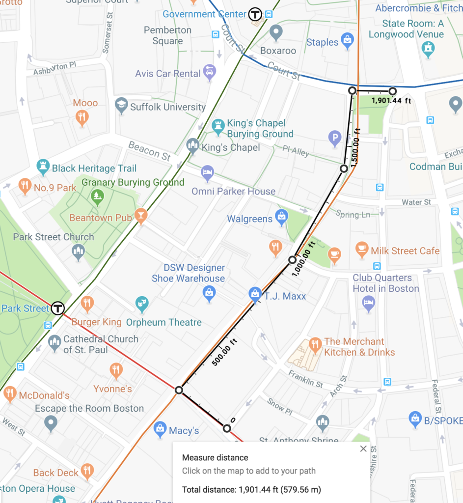
The Red Line runs beneath Winter and Summer streets. The Blue Line runs under State Street. These streets are, according to Google Maps (and, I assume, in real life), more than 1500 feet apart. But it turns out, that’s not even the real distance you’d have to walk between the subway lines. Boston’s subways were not built in a particularly coordinated fashion (although, unlike New York, which had two competing subway companies, the Boston Elevated Railway, or BERy, was the only game in town). The Green Line tunnel was built first, the Blue Line second (and, thus, below the Green Line) and the Orange Line tunnel third below the Blue (the Orange Line running through downtown predates the Blue Line, but for 7 years it ran on the Green Line’s tracks). Each newer tunnel went under the others, which is why the Green Line runs above. The Red Line wasn’t built until several years later, running below both the Green and Orange lines.

All of the lines were built within the confines of Boston’s notoriously old and narrow street grid, which was nearly three centuries in the making even then. So to fit stations in, and stairs between subway lines, both the Red and Blue Line stations are offset east of the Orange Line, and the Orange Line platforms are offset on separate sides of the subway to fit within the width of Washington Street.

Up until the 1960s, in fact, platforms were referred to as separate stations by the street they intersected, rather than station names. So the Downtown Crossing complex was referred to as Winter for the Forest Hills-bound platform, Summer for the Oak Grove-bound platform (then the Everett-bound platform) and Washington for the Red Line platforms. (It doesn’t help matters that most road names in Boston change at Washington Street.) Similarly, State was Milk-State on the Orange Line and Devonshire on the Blue Line. This seems nonsensical, until you think about it: to get to the Milk Station, you entered on Milk Street. To get to the State station, you entered on State Street. There are more examples; as this page posted long ago.

In any case, the Blue Line platform extends east from Devonshire Street, hence the name. The Red Line platform has entrances on Washington Street, but the actual platform begins around Hawley Street. To walk from Hawley to Devonshire via Washington? That turns out to be a walk of 1900 feet, up (or down) two stairs (since the Orange Line is built under the Blue Line, and the Red Line is under the Orange Line).

So where does this 600 foot figure come from? I’m actually not quite sure. What I think the number is indicating is the distance which would have to be dug between the two Orange Line platforms to provide a pedestrian connection between the Red and Blue lines. To make sense of this, we’re going to have to think in three dimensions (at least). Lucky for us, the Boston Transit Commission issued yearly reports during the construction of the subways in the early 1900s, and Ward Maps has them on their website (and has provided me with some high-resolution copies for this article, so shout out to Ward Maps for being excellent).

Remember that the Orange Line platforms are offset laterally. At Downtown Crossing, for instance, the northbound platform extends from Summer Street 350 feet north to Franklin Street, and the southbound platform south to Temple Place. In fact, the MBTA has been experimenting with new GTFS features to show the layout of Downtown Crossing, which you can view here. (Note, on the right side, the multiple levels; click B1 and B2 to toggle between.)

For the Milk-State platforms, this gets a bit more complicated. Washington Street is narrow enough at Winter/Summer: about 60 feet between buildings, but by the time you get to Milk Street, it’s narrower: only about 40 feet. Some of Boston’s oldest buildings stand here—the Old South Meeting House and Old State House date to the early 1700s—and the subway had to be built between the foundations; in the case of the Old State House, a subway entrance was built right in to the basement. (There are also newer buildings and, because reasons, parking garages.) This is barely wide enough for two subway tracks and a platform. So what did they do? They offset the platforms vertically: in effect, they stacked the trains.

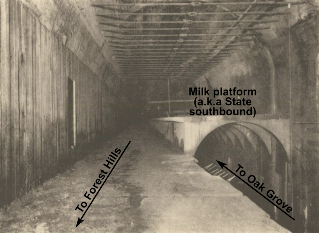
Here’s what the tunnel looked like just south of the Milk platform when it was under construction around 1906:

Original caption: Portion of platform of Milk St Station over the track for northbound cars. 
For orientation, the Old South Meeting House is approximately to your right (and above). Original file.

If you’re familiar with State station, this is the platform you exit off of coming on a train from Oak Grove. To get to the Blue Line, you walk along a corridor which is sort of an extension of the platform—dubbed, apparently, the speedway (from this detailed 1909 article on the tunnel), and now home to funky colors—and then the State platform, with trains to Oak Grove also to your left, and with escalators to the Blue Line to your right.

Here’s a map from 1913 showing the stations (and, yes, it’s the best map I can find of the actual locations of station concourses). I’ve shown current station names in all-caps, and former station names in lowercase; for DTX and State, I’ve outlined the platforms in their current colors and labeled the platforms with their original names. Note that while the Orange Line platforms were built 350 feet long, and only had to be lengthened minimally to accommodate six-car trains. (Original file from Ward Maps)

View the full-size version.
I think the idea to connect the Red and Blue line stations comes from the fact that the Milk platform (the southbound State platform) extends to Milk Street, and the Summer platform (the northbound Downtown Crossing platform) extends to Franklin Street, and those streets are only about 300 feet apart. I’m still not sure where the 600 comes from, but 300 is half of 600, so this should be twice as easy. Right?

Well, not quite. Look back up at the photograph above and imagine extending the Milk (Southbound State) platform shown 300 feet east (towards you) to meet the Summer (Downtown Crossing) platform. It would have to extend above the Oak Grove-bound Orange Line platform. When Oak Grove trains leave Downtown Crossing, then descend quickly to dive under the Milk Street platform pictured, descending at a 5.5% grade. So this would not be a level ramp by any means; in fact, a 5.5% grade exceeds the maximum allowed by ADA regulations, so it couldn’t even be built above the tracks with infinite space above. Which is kind of moot anyway, because it would also butt up in to the top of the tunnel pretty quickly. It would therefore have to jog south of Washington Street’s right-of-way, under the buildings there, which would add complexity to construction and yet more distance to the walk.

From 1906, here’s an elevation profile of the entirety of the Washington Street tunnel (now the Orange Line) connecting the elevateds north and south of the city (from 1901 to 1908, the elevated trains ran through what is now the Green Line, and the abandoned Pleasant Street Portal). I’ve added some annotation to it. The vertical orange lines show the ends of the platforms which would be used as the route for the pedestrian path. I’ve also shown the location of the Red Line (not built at this point) and the Blue Line (called then the East Boston Tunnel, or the E.B.T.). I’ve also superimposed the location of the other-direction Orange Line platforms on each drawing, and used black lines to superimpose other elements of the tunnel. I mainly want to draw attention to the fact that a passageway between the Summer and Milk platforms could not fit within the current envelope of the Orange Line, and would have to be built to the south, because to the north there are train tracks in the way, and to the south there is the minor issue of building foundations being in the way.

View the full-size version.

Again, this comes from Ward Maps, and the original file is here, and while the original has been sold (and, alas, not to me) you can get a reprint to hang on your wall (which I am considering).

So what are the takeaways from this little exercise?

  • While the Orange Line platforms and concourses would allow a connection to be made between the Red and Blue lines, it would amount to a walk of more than a third of a mile, up or down multiple staircases, and along already narrow and crowded subway platforms. That’s 8 minutes of walking, plus climbing some stairs, and that’s assuming you can walk at 3 mph down crowded platforms. At rush hour, it might take a good deal longer. It would probably be faster to just take the Green Line one stop from Park to Government Center, since the Green Line is directly above the Red and Blue lines.
  • The 300 feet which would be needed for an additional tunnel would have to go through and underneath the building foundations outside of the footprint of the street, because the Orange Line is already threaded under Washington Street, which is very narrow.
  • The entire utility of this connection could be realized by allowing an out-of-system transfer between Downtown Crossing and State, which will be possible with the new fare system currently being procured. It only adds one flight of stairs: two up from Red to street level, then one down to Blue.
  • This would do little to actually address the issue of core capacity, which is what the Red-Blue connector aims to address. Even if this was convenient for people to use, it wouldn’t result any less crowding on the Red Line, and the Orange Line and Blue Line platforms would actually become more crowded than they are today.
As the last point alludes to, the reason for building a Red-Blue connector—a real, actual Blue Line extension to Charles/MGH—is two-fold. One is to provide a good connection between the Blue Line and the Red Line. Perhaps as important, however, is to pull some of the demand out of the core stations of the subway. Rather than crowding trains and concourses at Park, Downtown Crossing, Government Center and State, riders between East Boston and Cambridge would be able to bypass the busy core of the system altogether. You get that if you actually build a Red-Blue connector tunnel. You get that only if you actually connect the two lines, not if you build a long, arduous pedestrian connection and sell it as an innovative piece of infrastructure.
And, alas, I still have no idea where the the 600 foot figure came from.

In the weeds: South Coast Rail

Sometimes I take some issue with CW’s headlines, but I like this piece overall. (I wrote it. Suggested headline was “to build SCR, look to the roads.”)

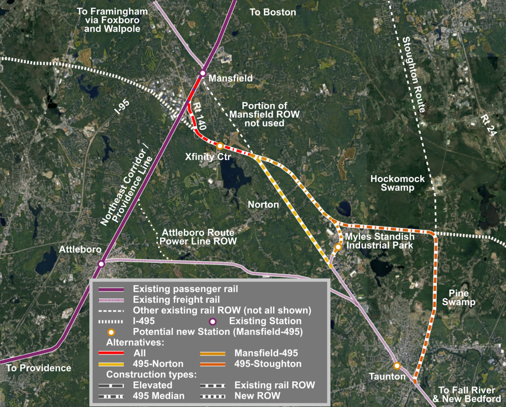
This image has an empty alt attribute; its file name is scr_alts-1024x823.png

A few in-the-weeds notes:

The route straight along the right-of way in Norton looks nice, but it has a few issues. It passes quite near to several homes, and would probably raise NIMBY issues. It is mostly owned by the town of Mansfield, which has a sewage treatment facility in Norton near the Taunton Line, and uses the ROW for a sewer pipe, which might have to be relocated within the right-of-way. There are some very low-angle grade crossings which would require extensive roadwork to make safe (or require grade separation). Extending down the 495 median to bypass this makes a lot of sense.

This post assumes electrification, although the original reason for the army corps to demand electrification was something about crossing the Hockomock Swamp. Still, electrification is the only way to allow high speed operations from Boston to Taunton, and between Taunton and Fall River and New Bedford. The maximum curvature on this portion of 495 is less than 1˚, which would allow 110 mph operation. Amtrak Regional trains reach Mansfield in 25 minutes from South Station, so even making stops at Mansfield and Myles Standish, an electrified Commuter Rail train could make Taunton in under 40 minutes.

Not only is the Taunton Station located closer to downtown using this route, it is also located adjacent to the main GATRA transfer point. Of course, fixing GATRA would help; Miles is not particularly enamored with their service. It would also be adjacent to some land which would be primed for TOD, and would likely increase in value if it were 40 minutes from Downtown Boston.

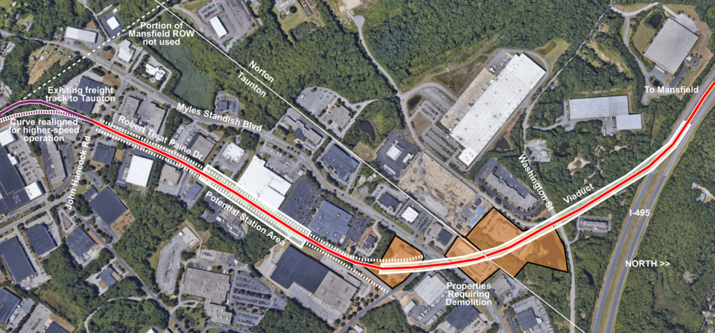
Myles Standish Industrial Park is sort of the wild card here. I am considering that having passenger rail access would be a net benefit, and that providing a right-of-way would not be particularly costly. The three buildings which would require takings would cost about $10 million; the additional land taking would add a bit more. I’d propose a viaduct to access the industrial park and cross the main roadway (Myles Standish Blvd)—which the current ground profile makes relatively easy—before running in the middle of Robert Treat Paine Drive, which could be relocated on to either side of the new rail right-of-way. It is at least 240 feet between any buildings in this corridor, the western portion of which has an overgrown and disused freight spur. A two-lane roadway could be built on either side with room to spare. The crossing of John Hancock would require an engineering decision of whether to build it at-grade or on a short overpass.

The map shows the path through Myles Standish, with the path of a new Robert Treat Paine Drive show in dashed lines on either side of the right-of-way.

The “station area” would allow access to most of the industrial park (although better bicycle/pedestrian access would help) and may allow zoning changes and higher density. There is no housing in the park itself, but some nearby. Here’s what a profile of the roadway might look like, and there is plenty of room for all of this. (And, no, I’m not sure you need an eight-foot-sidewalk plus a two-way cycletrack on each side of the roadway, nor two lanes of traffic and parking for a road which currently carries 1500 vehicles per day, but the room is there. Also, imagine the streetlights in the middle are catenary poles and wire.)

via Streetmix

There are two potential issues building in the 495 corridor. The first is environmental. 495 crosses through the Canoe River Area of Critical Environmental Concern (ACEC), a good map of which can be found here. This would raise some permitting issues, particularly since 495 crosses the Canoe River twice, to assure that steps were taken to mitigate any impact to the surrounding environment. The ACEC was designated in 1991, long after 495 had been laid out and built; it’s safe to say that if the highway were built today, it would be built with a smaller footprint which would preclude its easy use as a railroad right-of-way.

The second issue is that 495 has sloping concrete bridge abutments. This would require some construction to demolish portions of the concrete, shore up the remaining concrete, and provide a trackway for rail service. An example is here on the corridor, here is a situation in Maine where a slope was changed to a retaining wall to allow a highway widening. This would be a minor issue, although the rail bed might have to be undercut slightly lower than the highway to provide clearance for any freight and electrification. There are a total of five over grade bridges along the highway; the only new rail bridges required would be the two aforementioned crossings of the Canoe River.

Next, a proposal for the Mansfield Station. Mansfield is one of the busiest Commuter Rail stations, with more than 2000 daily passengers and some trains picking up or dropping off as many as 400 passengers. By boarding at fewer doors and forcing passengers to climb stairs, this adds several minutes to each train passing Mansfield Station, potentially adding 10 minutes to the run time from Providence to Boston for busy trains. The station is on the STRACNET—the military rail network—route to Otis AFB (or whatever it’s called now) and requires wider freight clearances at stations (you can find a map of STRACNET toggling around here) and that is cited as a reason high-level platforms can’t be provided.

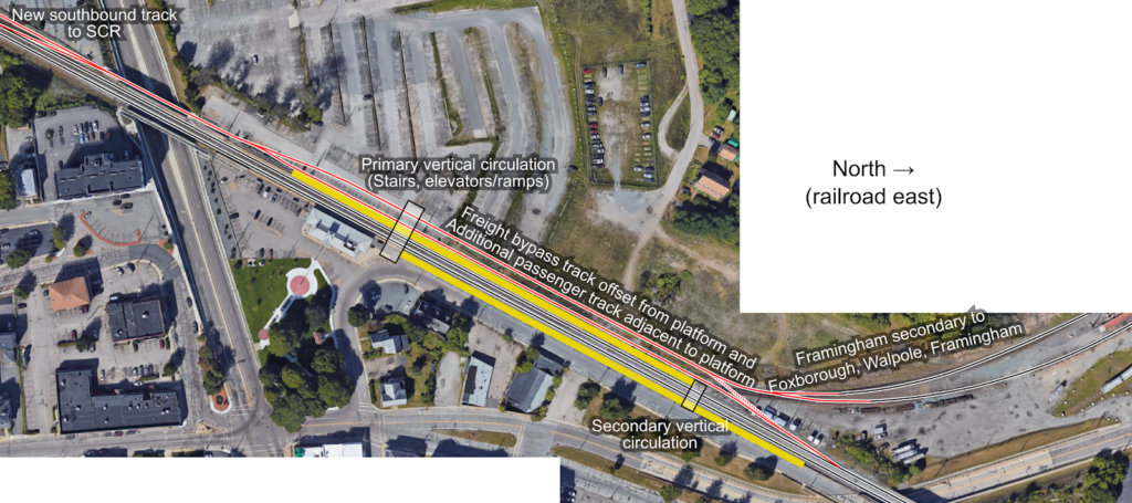
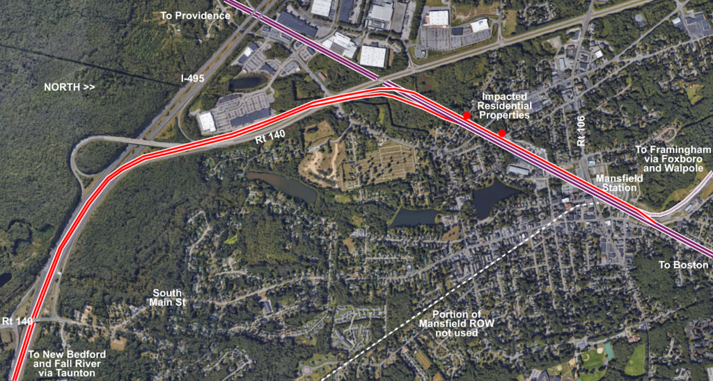
The idea would be to rebuild Mansfield Station as a three-track, two-platform station. The existing eastbound track (the number 2 track, “inbound” towards Boston) would remain in place, and a high-level platform would be built just east of the station house. The existing westbound track (the number 1 track, “outbound” towards Providence) would also remain in place, with a high-level platform built where the platform exits today. Two additional tracks would be added. The first would be a passenger track adjacent to the platform, branching off of the NEC east of the station. This would continue on as the southbound SCR track, eventually rising up and over the NEC to access 140 and then 495. (The northbound track would not have to cross the NEC and would merge in to the existing eastbound NEC track near West Street.) The second track would be a realignment of the Framingham Secondary, which would parallel the platform before merging in to the SCR and NEC west of the station, providing a wide freight route. An additional connection could be built between the NEC and the Framingham Secondary east of Mansfield if a wide route was needed there.

Sketch of the proposed layout of the Mansfield station, with red lines showing new track, and yellow showing platforms.
Sketch of route map showing the general track configuration from Mansfield to 495 (interlockings and small connections are omitted).

The original map (see the top of the page) proposes a station near the Xfinity Center. The concert venue is less-used than it once was (apparently at its peak, it hosted 80 shows annually, today it is more like 36) but it still causes traffic and today can only be reached by car (or, I guess, a cab or TNC from Mansfield). A park-and-ride station at Route 140 in Norton would provide a good park-and-ride location for people on 495 or who live in Norton and currently use the Mansfield P&R (with the additional benefit of reducing the number of people driving to downtown Mansfield just to park). The site there formerly contained an indoor soccer facility and has been vacant for years; there’s a plan to build a hotel there. MassDOT owns the three acres closest to the highway which could be used as a park-and-ride. As for the Xfinity Center, a train station would be about a 15 minute walk from the venue, mostly through the existing parking lots. Given the time to walk to a far-away car and get out is often longer than that, taking the train might be a good option for concert-goers.

Finally, another plug for a direct ferry connection in New Bedford with a station adjacent to downtown. Getting to the Vineyard today requires a drive to Woods Hole (or in some cases, New Bedford, Providence or elsewhere) but since the majority of travel is via Woods Hole, it requires crossing the Cape Cod Canal, in traffic, a two-hour drive from Boston or more at peak times. With parking, taking a shuttle to the ferry terminal and the ferry itself, travelers need to budget four hours to get to the Vineyard. With a 51 minute travel time to New Bedford from Boston and an hour-long ferry ride this trip could be turned on its head, with two-hour travel times from Downtown Boston. Considering that there are millions of ferry trips made each year, and that the majority of visitors to the islands don’t bring a car, this would provide a much more convenient trip to the island and would probably garner high ridership, while removing vehicles from the Cape Cod bridges at peak times.

Bus shuttle upsides: Finding opportunities from irregular operations

Starting next weekend, the Lowell Line will shut down on weekends for nearly six months, to allow the installation of Positive Train Control (PTC) and expedite track work for the Green Line extension. These are worthy and necessary projects. PTC will make the Commuter Rail system safer and more reliable, and GLX will bring better transit options to tens of thousands of daily riders.

No one likes a bus shuttle, but they do give us an opportunity to try new and innovative service patterns. Yet the T has taken the Lowell Line schedule and made it all but unusable, nearly tripling the duration of a trip from Lowell to Boston, while at the same time ignoring nearby resources—the 134 bus and the Haverhill Line—which would be duplicated by the Commuter Rail replacement service. TransitMatters recently wrote about how the MBTA could optimize Orange Line shuttles in Roxbury and Jamaica Plain using parallel Commuter Rail service, and this page has written about how the MBTA could optimize the Alewife-Harvard shuttle. This is a similar idea.

The Lowell Line dates to the 1830s—one of the first railroads in the world—when the Boston and Lowell Railroad was built as a freight line to serve the factories on the Merrimac. Its proponents underestimated the potential for passenger traffic and for the most part avoided existing town centers, yet the fast travel time—a stagecoach trip took most of a day, and even in 1835 the B&L made the trip in under an hour—attracted significant passenger traffic: an early lesson in the concept of “induced demand.” Two centuries later, the trip is still reasonably fast, direct and, because it was originally built to avoid town centers, hard to approximate with buses on nearby streets.

The railroad runs 25 miles from Boston to Lowell, while a bus zigzagging to serving each station runs 35, nearly all on narrow, local roadways. No wonder the schedule from Wellington to Lowell requires an hour and forty-five minutes. This is the reason that permanent replacement Commuter Rail service with buses on the weekend which is floated from time to time is a non-starter: buses are unable to efficiently make intermediate stops in town centers over a long distance. Rail service can, and, with the implementation of Regional Rail elements (i.e. level boarding platforms, faster-accelerating electric trains), could do so more quickly and efficiently than it does today.

As proposed, the Lowell Line bus replacement schedule makes use of Wellington’s proximity to I-93, and buses begin there, rather than downtown. This is similar to the busing taking place this summer on the Worcester Line, where buses have connected to the Green Line at Riverside. Yet for the Worcester Line, the T provides express service from Framingham to Riverside (which is significantly faster than the local route) and local service to serve stops in between. For the stations in Newton, no service is provided, but nearby bus routes, and the Green Line, provide service without slowing the trip from further out.

A similar concept could be applied to the Lowell Line. There is no redundant service for the outside portion of the route: a bus trip making each stop from Lowell to Anderson/Woburn is scheduled to take 45 minutes, as long as the full rail trip from Lowell to Boston. From there, rather than wending their way through Woburn, Winchester and Medford, replacement service could run express down I-93 to Wellington, reaching the Orange Line in an hour and, with a transfer, getting a traveler North Station in 1:15, not a particularly fast trip, but better than a two-hour crawl. For trips to and from Winchester and West Medford, no additional service would be required: it’s already there in the form of the 134 bus.

The 134 runs almost the exact same route as the proposed replacement shuttle. It passes through Winchester Center, within a stone’s throw of Wedgemere, and a half mile from West Medford (which is served directly by several other bus routes), from which it continues to Wellington. The service is provided hourly, which is more frequent than the Commuter Rail shuttles, so intermediate travelers from, say, Winchester to Lowell could ride into Wellington, and connect to a bus to Lowell. To provide the same span of service would require that a few buses—two on Sunday morning and two each evening—be extended by a few stops to Winchester (this might be something small enough that it could be done in the short term, without waiting for a new schedule). Most passengers would find taking the 134 as convenient, if not more so, than the replacement shuttles.

This idea would also save the T operating costs. The current Lowell Line shuttles are scheduled to take 1:45 from Lowell to Wellington, and 1:45 back. Running directly from Anderson/Woburn to Wellington would cut this to an hour, saving nearly 90 minutes of operating time for round each trip. With 16 round trips each weekend, this would save 22 hours of operation. Extending a few 134 trips to Winchester would claw back three or four additional hours of service, but it would still result in 18 hours of operating hours saved each weekend. Given that this project is slated to run from now until December, it will affect 20 weekends of service, and if a bus costs $125 per hour to operate, this would save the MBTA $45,000 in operating costs.

Another option, rather than running buses to Anderson/Woburn and on to Wellington, would be to skip the Anderson/Woburn stop—which is a large park-and-ride, so people using it could park at other, nearby stations—and run directly from Wilmington to Reading instead and connect to Haverhill Line service. This train runs parallel to the Lowell Line only a mile to the east, and Reading would be roughly a 40 minute ride from Lowell. The Haverhill Line weekend schedule would have to be increased slightly to provide the same level of service that the Lowell Line does: currently the Haverhill Line is served by only six trains on a weekend day, with three hours between trains. With the Lowell Line shut down, Keolis should have some additional staff available for these trains, since the net operation would still be less than the Lowell Line running. This would not only better-utilize existing resources and provide a better product to the traveling public on the Lowell and Haverhill lines (although the cost savings from less busing may be canceled out by running more trains), but it would draw in new riders to the Haverhill Line with more frequent service.

This table assumes a cost of $125 per hour for bus service, $750 per hour for rail service (estimated here), and that each train would only require a single bus.

Alternative Travel Time
Lowell↔Boston
Bus Hours Train Hours Cost:
per weekend | total
Local bus to Wellington 2:00 56 0 $7000 | $140,000
Express bus to Wellington 1:15 38 0 $4750 | $95,000
Bus to Haverhill Line 1:10 26 9 $10,000 | $200,000

Assuming you’d need two buses to handle any instances with more than 50 riders, the calculation would be:

Alternative Travel Time
Lowell↔Boston
Bus Hours Train Hours Cost:
per weekend | total
Local bus to Wellington 2:00 112 0 $14,000 | $280,000
Express bus to Wellington 1:15 76 0 $95,000 | $180,000
Bus to Haverhill Line 1:10 52 9 $13,250 | $265,000

While the Reading/Haverhill Line alternatives cost more (because they require more railroad operations) passengers would pay a Commuter Rail fare from Reading, nor does it take in to account additional Haverhill ridership, which would recoup some of this expense. Another alternative would be to have Amtrak’s Downeaster trains stop at Reading for bus passengers to Lowell, although capacity may be an issue. These estimates do not take a detailed look at how buses would be deployed, although the current schedule seems to show buses laying over at Wellington and Lowell for more than an hour, hardly an efficient use of resources. The Haverhill Line alternative, in particular, would allow a bus to make a round-trip in two hours, matching the frequency of improved train service there.

The installation of PTC gives us opportunities to experiment with different replacement service. Instead of simply drawing a line on a map, the T should be creative in leveraging existing infrastructure to provide the best possible product to the traveling public, while at the same time finding ways to reduce operating costs. These often go hand-in-hand, and the Lowell bus service is an example of how, with some small changes, the T could save time for its passengers and money for itself.