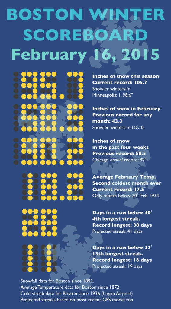
 |
| I’ll update this scorecard for the next few weeks. Follow @ofsevit on Twitter for the latest version |
A few weeks ago, I wrote about how unprecedented the weather has been in Boston, and how it affects the transportation system. How unprecedented is this February? It is the confluence of two 500-year events: temperature and precipitation have both experienced anomalies at least 3 standard deviations from the mean. It is without parallel.
We covered snowfall in the last post, here we’ll focus more on the cold temperatures.
There has been one month, in the recorded climatological history of Boston, where the average temperature was below 20 degrees. 1934. It was unprecedented cold: the all-time record-low was set in Boston at -18 (a temperature which, with the observation station being moved to Logan Airport in 1936, will likely never be matched; the airport has only recorded three days below -10, the most recent in 1957). The average temperature in February 1934 was 17.5˚. The next highest months were Januarys in the late 1800s when the temperature averaged 20.1 (records date to 1872). Winter temperature records are very nicely normally distributed (69/96/99.7; other months are similarly distributed but there is much less nominal variability in the summer), and there has only once been a a month more than 3 standard deviations from the mean out of more than 400 winter months. 1934.
It is quite likely that eight decades later, 2015 will be the second. The dreaded polar vortex last year gave us departures from the mean of 2 to 3 degrees. (To be fair, we were on the edge of the vortex last year, and the Upper Midwest had similarly anomalous weather.) This year, we’re likely to run more than 10 degrees below normal. The average high for mid-February is 40˚. We haven’t seen that temperature in nearly a month, one of the longest stretches on record.
 Thus far, temperatures in Boston have averaged 18.2 degrees, and if the forecast for the next week holds up, the average will actually fall below the 1934 record. With five days beyond then in the month, even if we revert to seasonal climatology normals (unlikely, given the current pattern and modeling), we’d set the second coldest month on record. If the weather stays cold, as is advertised, we’ll see the second winter month more than three standard deviations from the mean. And we might break the all time coldest monthly record. Which, given climate change (mean temperatures have risen 3-4 degrees since 1872), is particularly impressive.
Apparently it has snowed quite a bit as well. And, yes, the seven feet in three weeks has never happened before (and may well never happen again), and the past month has already outpaced any winter season in Chicago, New York or DC (and is one storm away from topping Minneapolis). But without the cold temperatures, it wouldn’t have had the same effect: some snow would have melted even with a few days over 40˚. In 1978, days in the 40s and 50s helped reduce the snowpack to 4″ before The Blizzard. In 2013, a week in the 40s reduced a major blizzard to a few inches of crust. This year, we haven’t seen 40˚ since MLK Day. The snow combined with the temperatures is really a double-whammy: two once-in-500-year events, at the same time.
 |
| From Sam Lillo @splillo |
It’s something no one could have planned for, and something we’ll never see again. And I do need to update one of the charts in that first post: the 28 day snowfall. The current chart is here. But it may increase.
Update: According to Sam Lillo, who has some great posts like this one, Boston has had more snow in the past month that Buffalo ever has. Will try to confirm (confirmed).
