This post was conceived of and co-written by an author who wishes to remain anonymous (I know who he/she is and fully support the content in the post).
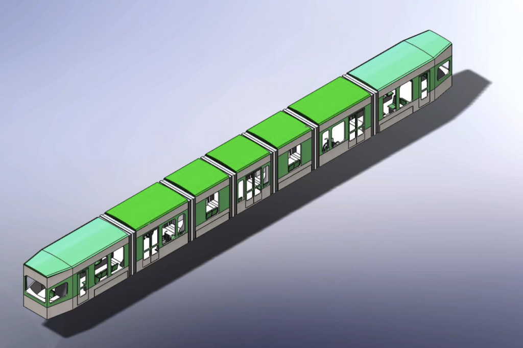 |
| The proposed design for the new MBTA vehicles. |
With the news that the MBTA Fiscal Management and Control Board is considering a massive revamp and modernization of the Green Line, including modern rolling stock, comes the necessity to consider the future of the E Branch. Additionally, the MBTA’s Focus40 plan for the next 20 years of the MBTA makes several recommendations for the E line, in particular, which we think could be implemented relatively easily and inexpensively, and would allow the T to provide better, more efficient service in the corridor.
However, the E branch, with its street-running segments in heavy traffic and simple loop terminal, poses a problem. Should the FMCB choose to modernize the system and acquire 100-foot-long cars, two-car trains of the new rolling stock will be unable to fit into the existing Heath Street Loop, one of the smallest on the system once the Lechmere Yard is decommissioned with the coming completion of the Green Line Extension project. This would limit the capacity of any trains serving the E Line, including in the Central Subway and the GLX.
In part as a result of the MBTA’s past lack of transparency about the Arborway line, the future of the E Branch is a touchy subject and a source of frustration for many. There are some in Jamaica Plain would obviously like to see the line extended back to the Arborway, but this is unlikely. This is due to the existing reliability issues on the mixed-traffic segment and the unlikelihood of gaining high-quality dedicated right-of-way on Centre Street (where the 39 bus suffers reliability issues) and which has a narrow cross-section which is, in certain points, just 40 feet wide (narrower than any existing streetcar line in the country with the exception of two blocks of the J-Church on 30th Street in San Francisco, where, it’s worth point out, it doesn’t snow), so a full-scale restoration still seems unlikely. Indeed, the E branch is the first line to be cut when the T runs short of vehicles; recently it has been relatively frequently terminated at Brigham Circle during the evening rush on some days, apparently due to a shortage of operable trolleys (or as the T’s Twitter called it: “disabled trains“). The T has been less than transparent about this, raising bad memories of the Arborway Line’s “temporarily suspended” days, which began in 1985 and lasted for decades (unlike the final 1985 shutdown, service has generally been restored in the evening).
Despite the state of the E Branch beyond Brigham Circle, and the challenges facing it in a modernized future, ideas for its improvement continue to pop up. The line is mostly constrained by a short section of street running near Brigham Circle, where the E Line shares right-of-way not only with the congested Huntington Avenue leading from Route 9 to the Longwood Medical area, but also the frequent 39 and 66 buses. Northeastern transportation professor Peter Furth and then-student Charlie Guo put together a proposal to create a dedicated transitway through this section, a corridor—and major bottleneck—identified by CTPS analysis as one where transit riders represent a high percentage of road users at peak hour. Meanwhile, the Go Boston 2030 plan suggests extending the branch, not all the way back to the Arborway, but to Hyde Square in the northern part of JP.
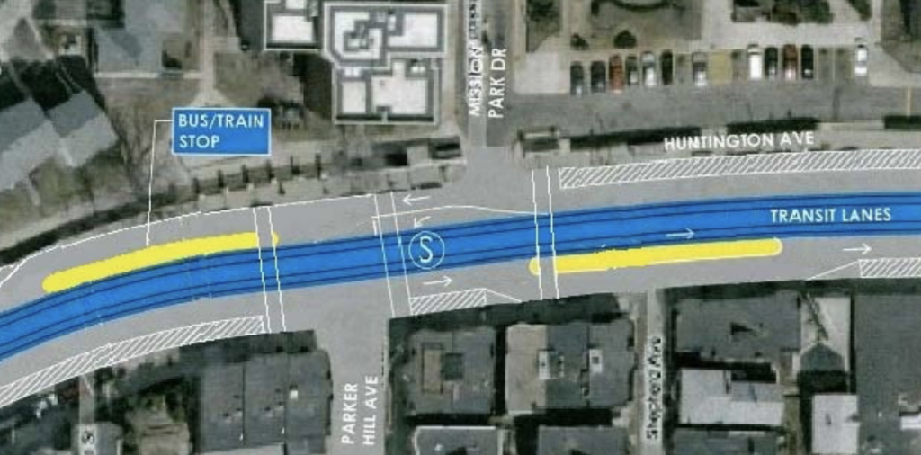 |
| The Furth-Guo proposal on Huntington Ave. |
Between the recent rush-hour cutbacks and the challenges that any proposed Green Line modernization would pose to Heath Loop, it is likely that if the E Branch is to survive beyond Brigham Circle, it is in need of a plan for modernization and improvement itself. Such a plan must satisfy several elements. It should:
- Preserve reliability for the entire E service. Unreliablity west of Brigham Circle can cause cascading delays down the line, which will become more problematic as the line is extended to West Medford.
- Be compatible with modern rolling stock
- Adequately serve, or even improve, the needs of current riders on the E Branch and the parallel 39 bus
- Increase overall capacity to meet the needs of the considerable development on the Huntington Avenue corridor
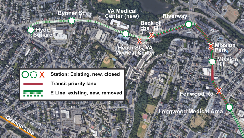
This post seeks to to combine the Furth-Guo proposal with additional dedicated right-of-way on South Huntington Avenue and follow the City of Boston’s proposal to extend the E to Hyde Square. Such an extension would likely involve some rearranging and consolidation of stations, not only in the section between Tremont and Riverway as in the Furth-Guo proposal, but additionally on South Huntington.
This Huntington Transitway would have several beneficial features. It would be designed to serve both trolleys and buses; since the E will likely never be restored beyond Hyde Square, there will always be a necessity for a frequent bus serving the Centre Street corridor. As such, while a center-running configuration is clearly preferable on the Tremont-Riverway section, a side-running configuration might be preferable on portions of South Huntington. This is particularly the case on South Huntington approaching the right turn on to Riverway, where the left lane, which is used by left-turning traffic and streetcars, is often congested, while the right lane flows freely. It would also allow an accessible, level-boarding station for trolleys and buses to be built integrated into the sidewalk.
While the right lane need not necessarily be an exclusive transit lane, moving the trolley cars from the left lane to the right—if geometry allows them to then swing into a center right-of-way on the leg of Huntington leading to Brigham Circle—would allow them to bypass this congestion. In the other direction, the right lane of Huntington Avenue westbound—the one which leads to the Jamaicway and Route 9—features far longer queues than the lane leading to a left turn onto South Huntington, so dedicating that left lane to transit should have minimal impact on queuing. Transit signal priority at this intersection would also allow transit vehicles to trigger favorable signals, rather than having to wait in queues.
In the Hyde Square area, finding an adequate terminal proves somewhat challenging. South Huntington is not quite wide enough for a multi-track terminal to be easily built (although it would probably be possible) and the most obvious off-street possibility, the parking lots on the Angell MSPCA property, are too far north of the main ridership generators further south in JP. One possibility would be to acquire the properties on the south side of Barbara Street, the acquisition of which would likely cost in the $2-$3 million (given their current assessment, and which could be partially recouped by allow development on part of the parcel or as air rights); these are currently single-story buildings housing small businesses, which could be offered assistance in relocation. This would allow for three tracks and two island platforms for the future 200-foot trains, which is similar to the Expo Line’s Santa Monica terminus in the Los Angeles area. Given the capacity constraints on the central subway, more-frequent service necessitating a larger terminal would likely not be necessary (and two tracks may be sufficient). This terminal would be well-located adjacent to a library and supermarket.
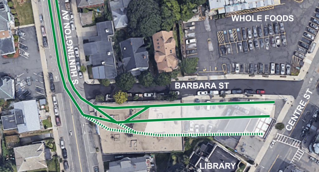 |
| A sketch of a terminal at Hyde Square south of Barbara St. The track shown as dashed may not be necessary. |
This extension would also allow a significant recalibration of bus service in the corridor, making the overall system more efficient. The current E Branch is the only branch of the Green Line which has peak demand in the reverse direction, with the dominant flow toward the Longwood Medical Area in the morning and away from it toward downtown in the evening. The parallel 39 bus has an opposite profile, inbound in the morning and outbound in the evening. This leads to inefficiency: there are often full 39 buses running parallel to empty E trains in one direction and empty buses passing by full E cars in the other. There are, in fact, four overlapping markets served along the Huntington Avenue-Centre Street corridor.
- JP Center/Forest Hills to Back Bay. While this is served by the 39 bus, most residents of this portion of JP are within an easy walk of the Orange Line, which is significantly faster.
- JP Center/Forest Hills to Longwood. This corridor not well-served by the Orange Line, but is served by the trunk of the 39 bus.
- Hyde Square to Longwood. This short trip is currently only served by the 39 bus, but if the E line were extended, it would provide redundant service along this corridor.
- Hyde Square to Back Bay. Hyde Square is the furthest point on the 39 bus from the Orange Line which is not also served by the Green Line. Thus, it is often faster to take the 39 bus downtown than to walk to the Orange Line, despite the congestion encountered by the 39 on South Huntington.
The Hyde Square E Line extension would allow simplification of this route structure. The 39 bus would still be required for the JP Center to Forest Hills trip. However, the two Hyde Square trips, which currently cause most of the crowding on the 39 bus, would instead be replaced by the E Line, which has plenty of room in this “reverse-peak” (as far as ridership is concerned) direction. Thus, the 39 bus could conceivably be truncated to the Longwood Medical Area, since the E Line would provide the necessary service from Hyde Square to Downtown and Back Bay (with service from JP Center to Downtown provided by the Orange Line, or by transferring). The current markets would be preserved, and the half-mile extension of the E Line would be balanced by truncating the 39 bus by three times that distance.
Stations would also be consolidated, to provide accessibility without too-close stop spacing. A single bus/rail station would take the place of Mission Park and Fenwood Road on Huntington Ave, serving the 39, 66 and E Line. The Riverway Station would remain, with the potential to build a level-boarding island for buses and trolley cars. The Back of the Hill and Heath Street stations would be consolidated up the hill and closer to the entrance to the VA. This would provide better access to the VA, the new apartments across the street, and place the station on a less-steep hill. A final station would be just south of Bynner Street (on a straight, flat area) before the terminal at Hyde Square. VA and Bynner could be designed as center platform stations for the E Line, and buses could stop in the travel lanes adjacent to them. This would minimize the need to remove parking spaces.
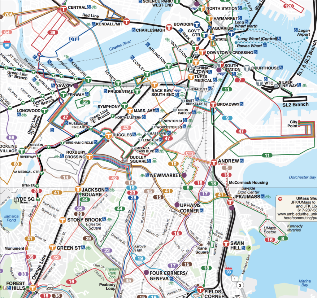 |
| A mock-up of an MBTA map showing the E Line to Hyde Square, the 39 Forest Hills-Central and the 47 LMA-City Point. |
- Be located in a corridor that is at or over capacity or will be in five years
- Increase capacity by 10%
- “not include project elements designated to maintain a state of good repair”

