
There’s an intersection in Boston, at the end of the Harvard Bridge, that I bike through all the time.
So do a lot of other people.
Today, one of those people didn’t make it.
|
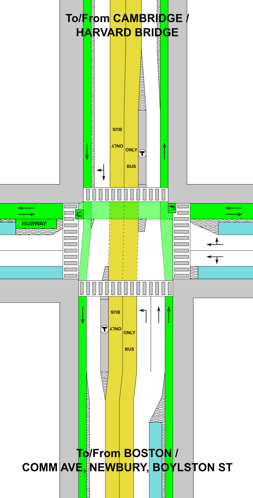
Legend:
White: Roadway
Yellow: Exclusive transit
Green: Bicycle
Gray: Pedestrian
Blue: Parking
“Wavy” = barrier or curb
|
The corner of Mass Ave and Beacon Street is dangerous. Like, really dangerous. It’s relatively narrow in both directions (i.e. not wide enough to easily separate uses), but still wide enough that cars can get up a decent amount of speed. It is heavily traveled by many modes, and has frequent buses and other large vehicles. Some of those things aren’t going away (no, we can’t kick the #1 bus out). We know it’s dangerous; we have for some time. Yet we’ve done nothing about it. Today, that has yielded tragic results.
But there are certainly things we could do. The intersection is dangerous for a variety of reasons:
- The bike lane disappears so that there can be three (3) lanes on the Boston-bound side.
- Buses pull in and out of the bike lane to make passenger stops.
- Bicyclists have no leading signal, so they have to go at the same time as cars.
- Cyclists accelerate down the grade off the bridge, quickly catching up on turning traffic.
- Trucks swing out to make wide right turns from the left lane, oblivious to bicycle traffic three, and cyclists don’t see the trucks turning right; trucks then turn across these lanes.
- There is frequently heavy traffic, so cyclists have to weave between stuck cars. When there’s less traffic, wide lanes allow cars to go fast.
- Beacon Street has three lanes of traffic east of Mass Ave, making it feel much more like a highway than a city street, despite traffic counts that would barely require two. (It has fewer cars than parallel Comm Ave, which has—wait for it—two lanes of traffic.)
- There are minimal bicycle facilities on Beacon Street, making cycling there especially dangerous.
- Put a bus lane on the Harvard Bridge, extending south along Mass Ave to Boylston Street (and perhaps beyond). Build a new station at Boylston in the center of the roadway (you’d need left-door buses for this, but these exist), safety-zone type stops like shown here but both adjacent to the Hynes station, or exclusive bus lanes on the sides with signals to allow the buses to move to the center of the roadway. (This could be extended further south as well, but traffic is usually not as bad south of Boylston.) At Beacon Street, install offset bus stations on either side of the street (there’s not room for a single station) with signal priority. Modal equity is a good thing. And despite my feelings about the ITDP’s bus study (this would hardly qualify as gold standard by their rankings with offset stations and lanes demarcated by paint and not concrete, but there’s not room for that), I think this is a great place for bus lanes! And by putting them in the center, you reduce any instances of buses having to cross and block the lanes to make passengers stops.
This will require removing only a couple of parking spaces on Mass Ave as the busway transitions in to the middle of the street to allow parking on one side. As far as I can tell, the businesses in the area have done fine without parking. Until Boylston, there are two ways of dealing with left turns. One would be to allow left turns from the bus lane, with a green light preceding any bus arrival to clear the lane. Even better would be to ban left turns all together, like San Francisco has on Market Street. This is safer for cyclists, pedestrians and vehicles, and addresses a major congestion issue (while allowing longer phases for straight movements). The few vehicles needing to go left could make a series of three rights (right on Comm/Newbury, right on Charlesgate, right on Marlborough/Comm) instead.
(Why not at Beacon, too? A northbound driver past Marlborough would have to go all the way to Cambridge to get back. So the left turn lane there fits and allows that movement, although it could be reassessed if it received very little use.)
- On Mass Ave, the southbound bike lane should be separated to the intersection. This is the most dangerous area, where cyclists are most likely to be right hooked as one was today. Bicyclists should have a separate phase to cross when there will be no other cross traffic allowed. At other times, cyclists could have a red signal for the straight or left (yes, left; more in a second) movement, but a green signal for a right turn on to Beacon Street. In addition, a curb or bollard south of the cycletrack on Beacon would require large trucks turning right to do so with much better visibility for cyclists, which could preclude the need to use specific bicycle signals to keep the users safe.
- South of Beacon, Mass Ave would be a bike lane without separation to fit in the bus station, but would transition to a parking-protected separated facility.
- Going northbound, the protected lane would similarly lose its protection at the stop. However, with no right turns possible, there would be no worry of a right hook. It would regain protection across the Harvard Bridge.
- The Harvard Bridge is currently two five-foot bike lanes and four 11-foot travel lanes. By reducing the travel lanes by one foot each, a two-foot buffer is easily attainable.
- Now, on to Beacon Street. Beacon Street is easy. It’s currently three 12-foot travel lanes and two six-foot parking lanes. There is no need for three lanes given traffic volumes on the street (just 7500 to 9500 per day!); two would suffice. If you pulled the width back to ten feet, you’d have 16 feet available to add two feet to each parking lane (8 feet instead of 6), a 2 foot buffer and a 10-foot-wide, two-way protected bike lane all the way to the Common. Which is why you’d need the aforementioned left turn from Mass Ave.
![]() Update 8/9: In the original diagram, I had near-side bus stops, but it is noted that
Update 8/9: In the original diagram, I had near-side bus stops, but it is noted that
far-side bus stops might work better from a transit signal priority point of view, and to allow for larger vehicles to make right turns. This turned out to be the case from a physical point of view as well inasmuch as it doesn’t require the busway to jog nearly as much if the parking moves from one side of Mass Ave to the other. The main issue is that cars would now be aiming right at the “safety zone” style bus stops and an errant car could drive in to a group of waiting passengers, but a protruding island could guide them towards the roadway. (By minimizing the amount of zigging and zagging, it would allow for more parking as well.) Another issue is that this would not accommodate the M2 Shuttle as well, as it turns right on to Beacon Street, but it could continue and go right on Mass Ave or have a separate stop further down Beacon Street. I’ve also added left turn boxes for cyclists. If you’re interested, the original design is shown to the left.
![]() I also have a design shown to the right which has much less transit priority but puts a two-way bikeway in the center of Mass Ave (with enough room for a jersey-style crash barrier on either side). While it would provide a quite-safe bicyclist experience for those going straight, there are a number of significant downsides:
I also have a design shown to the right which has much less transit priority but puts a two-way bikeway in the center of Mass Ave (with enough room for a jersey-style crash barrier on either side). While it would provide a quite-safe bicyclist experience for those going straight, there are a number of significant downsides:
- Bicyclists turning right would have to cross traffic at an intersection, and could not pull to the curb.
- It would be very difficult to design a means for cyclists to enter and exit this cycling facility from the Paul Dudley White bike path along the river.
- Turning movements for cyclists between Beacon and Mass Ave would also be difficult as there would be nowhere for cyclists to wait for a turning phase, which would be required for all turns.
- Where, inevitably, bike lanes move from the middle to the side it would be an awkward transition (as is the case with the Comm Ave bike lanes at Charlesgate).
- The potential for transit improvements are minimal. The main benefit is that there would be no need to transition transit from the middle to the center as would be the case in other scenarios, but buses can more easily signal across mixed traffic. However, transit would only share a lane with right-turning vehicles, and the only way to really improve bus speeds would be to somehow assure that drivers didn’t use the right turn lane to bypass traffic and then attempt to merge back in. Good luck with that.
Nitpick on the diagram: heading north you have two lanes for going straight into the intersection, but only one northbound lane leaving the intersection. I think you may have used the wrong arrow.
Yes, you're right. Why I called it off-the-cuff. Thanks. Fixed.
This would help and might stop a future tragedy like what happened today.
I do wonder about transit stops in the middle of the street. You might need more room and heavy fencing to help passengers waiting or just getting off of buses. I'd like the protection that passengers get here (Comm Ave Green line stop, Google Streetview)
That all said, Boston should be taking a serious and detailed look at this intersection and get to work on it fixing immediately. No one else should die there.
I'm not sure about it either. I've given it 5 feet, which could conceivably be expanded to six or seven—maybe—but cutting a foot or two out of travel lanes or in to the sidewalk. This is the width of the Harvard Ave B Line stop, so while not wide, wide enough. Putting the stop in the middle of the street means that buses don't have to cross the bike lanes to get to stops, which is safer for everyone.
Alternatively, you could have the island be between the (protected) bike lanes and the bus lanes, with the bus lanes on the outside. Curbside bus lanes are problematic for other reasons, but might be more convenient at Boylston St with the reopening of the pedestrian tunnel under Mass Ave.
easiest solution ,make bike riders take the bus
easierest solution… make drivers take the bus… saves way more space……
Your diagram seems to show near side bus stops. Aren't far side stops preferred with transit signal priority since dwell times are unpredictable, but with a bus approaching an intersection with a far side stop it is relatively easy to predict when the bus will reach and enter the intersection?
While the idea of separate phases for automobile right turns vs bikes going straight is appealing, I am skeptical that every cyclist will respect a long red. I wonder if putting the buses in the right lane, and having the southbound outside lane be shared between buses and right turns for 100'-200' to the north of the intersection might work well; that would allow right turns to get out of the way of automobiles going straight while bikes have a green for straight movements.
Also, the automobile right turn signal head could be set up with steady red, steady yellow, and instead of green, blinking yellow, although perhaps the blinking yellow would be imperfect in telling drivers that they specifically should be looking for bikes in the lane to their right, and bright green paint for the bike lane across the intersection might be good.
Is there any particular reason to prefer putting the Beacon St cycle track on the north side of the street? Some probably think having the contraflow bikes ride on the right may be less confusing to motorists at intersections.
Do any of the Beacon St buildings have driveways that would cross the cycle track?
If there needs to be an M2 bus stop on the right side of Beacon just west of Mass Ave, then moving the cycle track and hubway station to the south side of Beacon may also be helpful for making space for the M2 stop.
From the perspective of a bicyclist, is it better for the bus lane or the general travel lane to be immediately next to the bike lane on the bridge?
If the bus lane is next to the bike lane, the gap between buses may feel like an extra 10' buffer between the bike lane and general travel lane, and maybe the bus lane could be a bike passing lane in between buses.
The bus lanes you propose here also have the potential for helping with extending the route 28 bus further north; if you draw a straight line as the crow flies from Mattapan to Dudley, it continues almost directly through Kendall.
I always thought the travel lanes on the Mass Ave Bridge were 10'. Are you sure they are 11'?
You may be correct; I was looking at the portion crossing Storrow which is slightly wider. Still, they could probably go down to 9.5 and have a 1-foot buffer (grooved, perhaps, with bollards) or something of the sort. It also might lend more credence to having side-running bus lanes to act as buffers between traffic and cars; I guess the question is whether it's safer/more comfortable to have a bus pass close by every couple of minutes or cars more constantly. If and when the bridge is rebuilt (last reconditioned in 1989, before that in 1950, so probably within the next 20 years) a few extra feet of width would make a ton of difference.
You can't really run an 8.5 foot wide bus in a 9.5 foot wide lane though, not without it overhanging into the next lane at least occasionally. And if that next lane is a bike lane, that is a problem.
To make space for a bigger buffer next to the bike lane, we could also consider using a three lane configuration similar to the BU bridge, but perhaps where there are two lanes for one direction using one lane for buses and the other for other traffic, or if using the outside lane as the bus lane, maybe right lane for bus + right turns to Beacon / Memorial Drive (which might also encourage more single occupancy vehicles to turn off Mass Ave at these points, which might reduce demand for the single occupancy vehicle lanes on Mass Ave beyond those intersections).
If the traffic lights controlling traffic moving onto the bridge limit the green time appropriately, it should be possible to prevent the segments where the bridge lane is shared between buses and general traffic from accumulating a queue of stopped cars. (Having sensors to tell the signal controller how long the queue on the bridge is is key to making this work.)
I'm wondering if it would make sense for MIT to fund the reconfiguration of Mass Ave from Memorial Drive to Albany St to eliminate all of the on street parking, put protected bike lanes on the outside, then bus lanes, and one general travel lane in each direction at the center of the road (is that sufficient for traffic volumes?), letting general traffic into the right lane for right turns near intersections, and maybe also having some left turn lanes in appropriate places.
MIT probably could find space on its campus to build replacement parking spaces for what Mass Ave would lose; I seem to recall hearing that on campus parking is limited by road congestion and / or air quality concerns and not space / funding.
Google Maps and NextBus seem to not be in agreement about whether 1 stops at Vassar or Albany, but in any case, there don't seem to be any bus stops between Albany and Sidney, so having bus lanes at the center from about Albany to Sidney might work well to keep buses away from cars stopping to back into parking spaces.
I probably was confused by the CT2 stop on Vassar, and it looks like Google Maps may not be marking the northbound 1 stop at Albany at all.
But this leads to an annoying question about where the optimal place for 1 to stop is to facilitate transfers to both CT2 and EZRide.
Assuming that Mass Ave is 90' of ROW and Beacon is 70'.
http://streetmix.net/andr_w/10/mass-ave-at-beacon-facing-bridge
^^ Just did a check using streetmix on the north leg.
http://streetmix.net/andr_w/12/beacon-st-facing-kenmore
^^ Also the East Leg
As for the intersection design itself, I could definitely see the case for a more protected style intersection with the stop-bars stepped back by maybe a half-car length, this would necessarily push back the stops from the intersection too and perhaps also allow for a more secure barrier. And then providing for priority crossings at the crosswalk and crossbike/s