Cambridge is in the process of starting a citywide master plan (right now it’s in the naming phase). The major thoroughfare in Cambridge is Massachusetts Avenue (Mass Ave for short, of course), and it is pretty much the only street in Cambridge that is more than two lanes each way. Except for a couple of locations, north of Harvard Square Mass Ave is 72 feet wide, and it could be a great street.
Unfortunately, it’s not. It’s basically a highway.
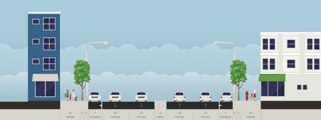 |
| Two wide lanes of traffic each way, parking and a median. Are we in Cambridge, or LA? All diagrams shown made in Streetmix, which is a fantastic tool for this sort of exercise. |
And that needs to change. The street currently serves two functions well: traffic and parking. There’s minimal traffic on Mass Ave because there is ample capacity (the bottlenecks are at either end of Cambridge). There is plenty of parking; nearly the entire stretch of the street has parking on both sides. And since the street is so wide, there is a median to help pedestrians cross, discourage left turns and make the traffic even faster. It is also a concrete waste of six perfectly usable feet.
The street does have 14 feet of pedestrian facilities on either side, but these are hardly enough for the various uses there, which include bus stops, bike racks, sidewalk cafes, building access, power and light poles, etc. And the current lane width is ridiculous. Each side of the street is 33 feet wide: a 7 foot parking lane and two 13 foot travel lanes. Considering that Interstate travel lanes are only 12 feet wide, and 10 foot lanes are used throughout much of Cambridge, this is far, far more width than necessary, meaning that with the median there are 18 wasted feet of space on Mass Ave. Wider lanes cause drivers to speed, which endangers other street users. As for transit, the 77 bus limps along Mass Ave, stuck in traffic and pulling to the curb at every stop, only to wind up stopped at a light behind the cars that passed it.
We need to re-plan Mass Ave, and we need to rethink our priorities. In the 1950s, when the removal of transit safety zones in Mass Ave sped traffic and the end of the streetcars (at the City’s behest, no less), the main priority was vehicular traffic, with no mind paid to cyclists, little to buses, and not much to pedestrians. This is nearly completely backwards. How we should plan is:
- Pedestrians. Every street user other than a pass-through driver is a pedestrian. We need to make sure crossings are manageable, sidewalks are wide enough, and traffic is slow enough to be safe.
- Transit. Right now there are four bus lines along Mass Ave, the 77, 83, 94 and 96, carrying 13,000 passengers daily (as opposed to 20,000 vehicles). In addition, the street serves as the pull-out route for the 71 and 73 buses, serving 10,000 more. At rush hour, there may be a bus every two or three minutes.
- Cyclists. Safe cycling infrastructure is imperative for Mass Ave, as it is the straightest line between Arlington and North Cambridge and Harvard Square and points south and east. It is also the main commercial street for the neighborhood, and safe cycling facilities will allow residents to access businesses without driving. Rather than shunt cyclists to roundabout side streets, we should give them a safe option on Mass Ave.
- Cars. Yes, we need to provide for vehicles. We need a lane in each direction, enough parking to serve businesses (likely on both sides) and turn lanes in a few selected locations. Do we need two lanes in both directions? Certainly not; there are plenty of one-lane roadways which accommodate as much traffic as Mass Ave. And if we build a road that’s better for pedestrians, cyclists and transit users, many of the current drivers will travel by foot, bicycle or bus instead. We also need parking, and there’s enough for parking on each side. It would be eliminated where there are bus stops, but with fewer overall stops there would be only a minor loss of spaces. And with better non-driving amenities, fewer people would drive, anyway.
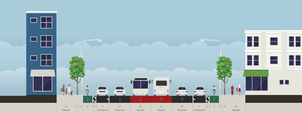
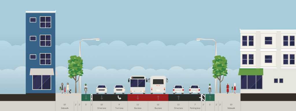
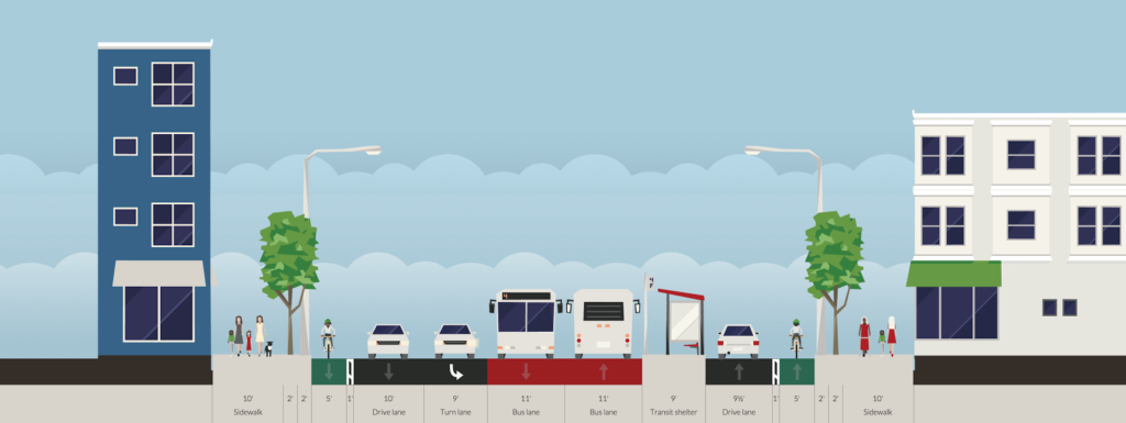
This is a typical section of street. The curbs and sidewalks are unchanged, but everything else is. Cars get one lane, plus parking. There are center bus lanes, which also allows cars to pass people parking, or a double-parked car, although this will require enforcement to keep drivers from using the bus lanes for travel or turns. Each lane is 11 feet wide, and emergency vehicles would also use the bus lanes to bypass traffic. On each side of the street, there is a 5 foot bike lane separated from parked cars by a 2 foot buffer (the bike lanes could either be at street or sidewalk level). This would be the baseline configuration of the street.
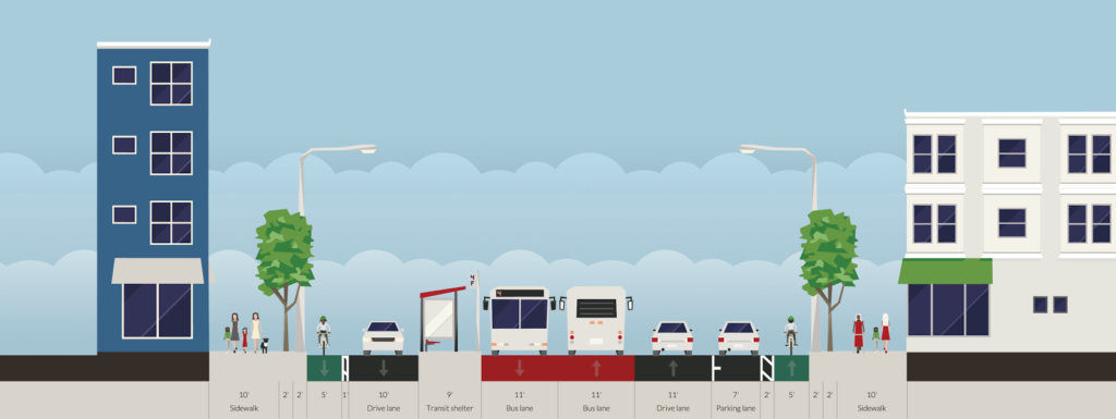
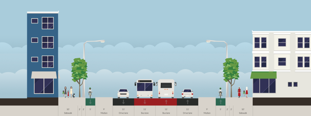
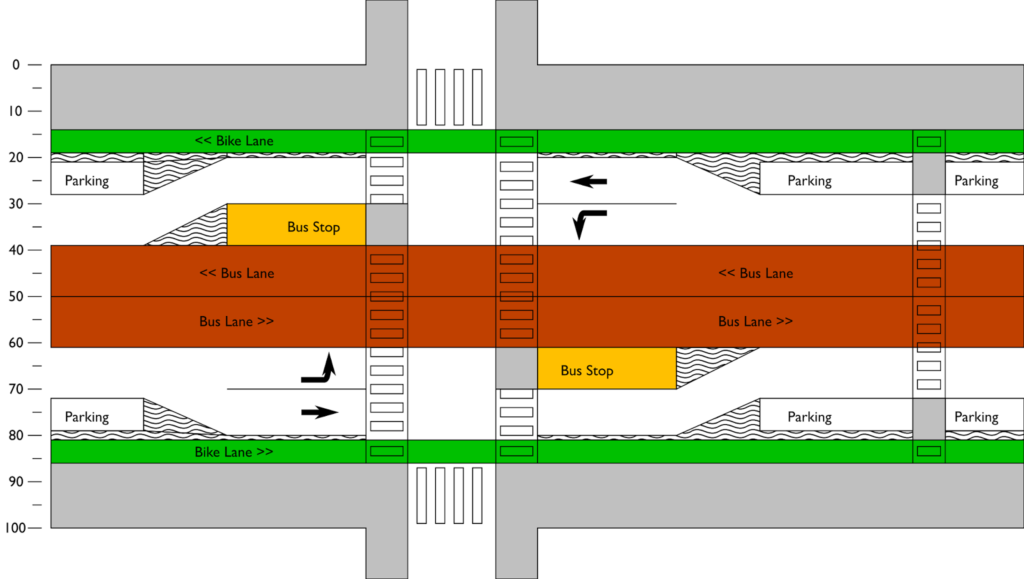
When a crossing of the roadway is desired away from a bus stop, the parking lanes would be replaced with curb bumpouts beyond the cycle track, meaning that pedestrians would only have to cross four lanes of traffic—44 feet—instead of the current 72. Crosswalk treatments would be included in the cycletrack to warn cyclists of the pedestrian crossing.
A turn lane could be accommodated by reducing parking in a manner similar to a bus stop. This would often be paired with a bus stop opposite the turn lane, with through traffic proceeding straight and the turn lane becoming the bus stop.
What would it look like from above? Something like this:
In the 1950s, we planned Mass Ave for cars. Cambridge can do better. In 2015, we were honored to have built what was described as the best new bicycling facility in the nation. It’s high time we remake Mass Ave, this time for everyone.

Is the median really 6' and travel lanes 13'? I haven't measured, but having driven it and walked across it I would have guessed smaller numbers for both. To me the lanes feel cramped, and when I've biked to Arlington during rush hour the road seems pretty full, not just at route 16. That said, as a city cyclist first, I do like road diets. I just wonder if we can actually keep things moving at rush hour with this configuration.
The roadway on each side is 33 feet, with 6 feet of median. use the Google Maps measure distance tool and zoom way in. It's apportioned more like 7' parking, 14' right lane, 12' left lane, but since when do people in Boston pay attention to lane markings?
The traffic counts for the road are about 20,000 per day, similar to Prospect Street and other similar streets. Narrowing the road to one lane would likely cause more traffic in the short term, but in the long term people would find other routes and modes. We shouldn't build our roads for the peak auto usage at the expense of everyone else.
I agree, and part of making this sort of change work would ideally be providing appealing alternatives. A bus-only lane would vastly improve the current bus line. But how do we make alternatives more attractive for people going to Kendall or Boston from the Lexington/Burlington area? These are people who (based on my experience at work) seem to prefer driving in and the alternatives I think aren't good enough. For instance, I'm surprised that I don't know anyone who drives and parks at Alewife to take the Red Line inbound. I know traffic there is a huge mess, but can it be worse than driving to Kendall and paying astronomical parking rates? Maybe that parking lot fills up? What other options are there? Driving down 95 to the Fitchburg line is not any better.
That parking lot fills up. A rational person would park somewhere near Fresh Pond/Alewife Brook Parkway and bike in to Kendall Square — parking, if you can find it, is cheaper, and at rush hour that distance is faster by bike (I do it every day, I pass a mess of cars, and I am far from the fastest person biking).
May we consider some broader scenarios? The average car spends 95% of its time sitting in place. What if Cambridge and metro Boston replaced most street parking with protected bikeways? What would be lost? What would be gained? http://www.motherjones.com/environment/2016/01/future-parking-self-driving-cars
Self-driving cars have been tested in places like Mountain View. When they can cope with a day like today in Boston (and Boston traffic, pedestrians, etc in general) let me know.
And you will still need places for cars to drop people off, to wait for people who are late, for vehicles to make deliveries, etc. You can't get rid of all street parking. This "self driving cars are the panacea for everything" is a myth. If self-driving cars are widespread in urban environments in the next decade, I'll be quite surprised.
First, Ari, self-driving taxi service is presently available in Singapore, Switzerland and other places. Don't be deceived by the media monopoly and Googlemania. This isn't sci-fi. They're here today, and they're much safer than human-driven vehicles.
Second, I never said that self-driving cars are a panacea. I did, however, suggest that Citywide Networks of Protected Bikeways might reduce traffic congestion, accidents, pollution and many other costs very dramatically (perhaps more than 50%) and make cities into the places they should have been during the last century and might become in the future:
http://www.peopleforbikes.org/blog/entry/calgarys-quick-build-protected-bike-lane-network-doubled-bike-counts-in-thr
Love this Ari. Would love to see a similar plan for Mass Ave from the Harvard Bridge through to BMC/Expressway Connector.
That's a lot harder. The street width is only 88 feet there.
Of course, it's totally doable. http://amateurplanner.blogspot.com/2015/08/its-time-to-radically-rethink-mass-ave.html
Wow this is an amazing plan especially the bus lane and stop system you present here it would be amazing how much more timely the bus routes on mass ave could be with this.
They absolutely could. In the long run, wires could be reextended to Arlington Heights and the 77 could be run under the wire (quieter, with better acceleration, and since the yard is half way to Arlington anyway, less deadheading).
It would also have benefits for Lexington/Burlington riders to answer Ryan's point above. The 62, 76 and/or 350, instead of going to Alewife, could extend to Kendall, replacing the 68 along Broadway (this might require some bus priority on Broadway from Kendall to Prospect Street, which regularly backs up at rush hours). This would enable a one-seat ride from Burlington, Lexington and Bedford to Kendall Square while bypassing the traffic on Mass Ave and still allowing for a Red Line transfer at Porter (or Kendall). Even the 94 and/pr 96 could be extended to Kendall for a Medford/Tufts/Kendall direct ride. All of this would take some pressure off the overextended Red Line, too.
I haven't used the Western Avenue Cycle Track but I regularly ride the separated cycle path parallel to Concord Avenue at Fresh Pond and it does not work. Pedestrians have absolutely no idea that it's supposed to be separate users on separate surfaces. Yes there are painted on symbols to instruct cyclists to use the asphalt portion and pedestrians to use the concrete portion but in reality people walk everywhere. Is it any better on Western Avenue? I can't imagine cycling the length of Mass Avenue from Porter to Arlington dodging strollers, Runners, pedestrians and iPhone distracted walkers. Maybe there's something unique about the Concord Avenue side path that makes it incomprehensible to pedestrians that would be different with this model, if there is please explain.
Concord Avenue was a much earlier version of the cycletrack in Cambridge. Western Ave works much better: it's separated from pedestrians by the street trees and pedestrians only cross it to get to the curb for parked cars, to cross the street, or to access the bus stops, which are located on the street-side of the cycletrack, so that riders don't have to walk across the bike path when a bus pulls up.
The Concord Ave cycletrack was a learning experience for the city; the new version on Western Ave is much, much better. It's not perfect, but it's much more comfortable than riding in mixed traffic or a bike lane butted up against parked cars. Try it out, you'll see it's far different than the cycletracks on Concord or Vassar (and similar to the new one on Binney).
This one would be similar inasmuch as cyclists would be between the cars and the street trees, not sharing a poorly demarcated sidewalk with pedestrians. And by moving bus stops to the middle of the street, the bus/bike issue would also be solved.
This is odd, because I don't see this, especially not from the problem with pedestrians. I also ride that cycle track, and I find the Fresh Pond side relatively pleasant. The other side is nuts, but not because of pedestrians, but because it is filled with dirt, is not a single level, the sidewalk next to it has lots of obstacles embedded in it, and there's quite a few streets and driveways cutting across it.
So how do we both see the same path so differently? Are you moving really fast? Am I moving really slow? (Summer time, I often hit 20mph on the first downhill part from Belmont). Do we have different attitudes towards what acceptable personal space? Or is it because I'm not that much bothered by who is where, as long as overall there's enough room?
Concord Ave isn't bad, but it's an earlier iteration. The westbound side does have some suboptimal stretches, and the Fresh Pond side could use better separation (it's more like a multiuse path next to a road). The non-Fresh Pond side, if built today, would probably be built with raised intersections and floating bus stops. It's not bad, but if we built it today, it would be better.
I'm a regular commuter, I ride faster than most commuters. Hard to say how fast as my commuting bike as no data. I certainly ride fast enough that I am uncomfortable riding narrow paths or narrow gaps between obstacles.
I commute on the portion of Concord Avenue that is also route 2 that is the section where the bike path is both directions on the same side of the road and with pedestrian road all side-by-side same level. That doesn't work. That is where I typically find pedestrians walking two or three abreast in the bicycle section. When I either say excuse me or ring my bicycle bell I get a look from the pedestrians that implies that I am being an ass hole. I don't like alienating pedestrians so it's kind of difficult. The other section of Concord Avenue west of Route 2 is slightly better but the fresh pond side is not a a reasonable analog for any place else in Cambridge. Because there are so few cross streets that any infrastructure would work. The other side north side is pretty awful, one cannot ride it quickly as it has many changes in grade. You also can't ride it on trash day because it is full of trash cans it is also used as the loading and unloading zone for UPS trucks etc. I think it is unlikely that snow will be kept off of bike paths that are separated from the road by parked cars. Where our trash cans going to be placed in the streetscape? I also foresee a problem with cars on cross streets. Drivers attempting to enter mass Avenue necessarily need to pull across the bike path in order to see the street well enough to enter traffic. While they are queued up waiting they are blocking through traffic for cyclists. Because cyclists are separated from mass Avenue by parked cars they are unable to shift left to avoid cross traffic cars. If the user base was only drivers and pedestrians your plan would work very well. It is unfortunate for your scheme that it excludes such an important user group. I recognize that planning infrastructure for cyclists is difficult.
Check out Western Ave. It works pretty well, and addresses most of the issues you cite here. And that section along Fresh Pond is awkward because of the double-crossing required to avoid the rotary. Luckily Mass Ave has less than half as much traffic as that area, so it would be much more manageable.
I find it funny hearing that concord ave was a learning process. It's not the first time I've heard it. These types of paths are pretty well established in Europe, why do we have to re-invent it?
@ Ryan: It is interesting, but the Concord Ave cycle track on both sides is very similar to then-current Copenhagen style infrastructure.
I think if the cycle track were at street level instead of sidewalk level it would keep most pedestrians off it. Western Ave is good but i still notice lots of pedestrians in the cycle track, especially when there are larger groups of pedestrians walking togother.
94 runs from Medford Sq to Davis Sq via West Medford station and never runs on Mass Ave.