At some point on the Internet, I’ve scoffed at the idea of extending the Blue Line across the Longfellow Bridge (somehow) and then run along Main Street to some superstation at Kendall (which there’s not room for) and then making a turn on the Grand Junction right-of-way (or something). I still do. You couldn’t reliably run the Blue Line and Red Line together on the Longfellow and they have separate loading gauges so would need different tracks at Kendall. To facilitate a Red-Blue Connector, it makes sense to stub-end the Blue Line at Charles Station and provide an easy answer to Kendall Square.
Or does it?
This would be a short and pointless blog post if the first paragraph was 100% true. Plus, I’ve written that blog post before. Twice.
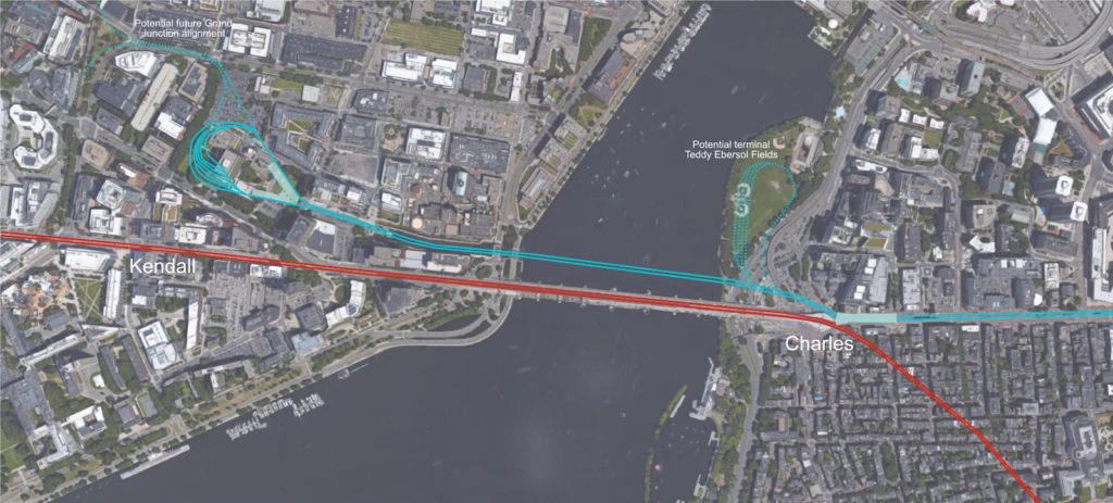
One of the trickiest things about the Red-Blue Connector is shoehorning a good, useful terminal in to the space under Charles Circle. It’s not easy. You’d have to dig a wide tunnel, or long tail tracks, or dig out pocket tracks or tail tracks under a busy roadway and the supports for the Red Line. It would be somewhat difficult to build any sort of functional terminal: there’s just not the space. You could put something under Storrow Drive (technically Embankment Road) and Ebersol fields, which would result in a decent terminal, but you’d have to dig up and rebuild the fields, and you’d be digging adjacent to the river. It would provide for good operations; you could stack in several tracks for layover, storage and recovery, rather than using crossovers and/or the Bowdoin Loop.
So Ebersol would work for operations, but you’re still pushing more people in to the Red Line and the already-overburdened Kendall and Charles stations, and forcing every Kendall-bound Blue Line passenger to transfer (albeit an easier transfer than exists today). There’s another potential terminal. It’s bigger than Ebersol, would allow increased capacity across the Charles, the potential for further expansion and, oh, yeah, it’s already somewhere where a huge hole is going to be built in the near term.
I’m speaking of the Volpe site recently bought by MIT. Since they’re going to be digging a big hole, it would make sense to put something useful in it, not just more parking. It is an extra 3000 feet to tunnel from Charles Circle to Volpe, but it’s mostly in a shallow river and free from utility considerations (as far a I can tell). In theory, this should be relatively cheap tunneling: it could be done in a similar manner to the Ted Williams Tunnel: building tubes off-site, digging a trench, and sinking the tubes in to place, except downscaled by a significant factor: the width of two Blue Line trains is narrower than two highway lanes. The river is 12 to 15 feet deep just downstream of the Longfellow, so it would need to be excavated down about that much to accommodate current depths. The TWT required digging through muck and in to bedrock at times to accommodate a shipping lane clearance at low tide, but the Charles has no such river traffic. The disposal and mitigation of the sludge on the river bottom may be the trickiest part, although it would be beneficial to start cleaning up the muck on the bottom of the Charles River.
Then there’s the Broad Canal. This should be easy. It’s 15 feet deep, doesn’t need clearance for anything more than kayaks (although the waste heat from the power plant would have to be accounted for), and could be easily coffer-dammed, dug out, cleaned up, and filled in with several feet of water sheet above. To make up for any displaced water volume (hello, Waters of the United States), the canal above could be extended, Lechmere-style, to a water feature figuring in prominently in the new Volpe development.
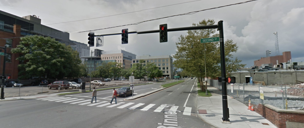
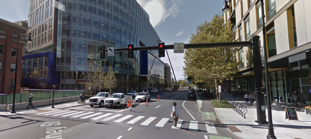
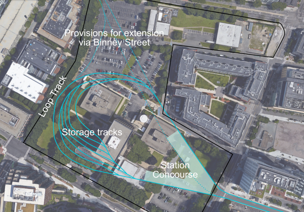
What does this get you? A lot, actually. First of all, designing a subway loop terminal in Volpe’s basement would add minimal marginal cost to the development and would make it extremely transit-oriented, and add value to the project: there’d be no need to trek through the Marriott to Kendall Square to the Red Line for trips downtown. (Do you need a loop? Probably not, but if you can get MIT to dig the hole, you might as well put a good terminal down there, although if you wanted to run trains through to Binney and beyond in the future, you could build a simpler island platform with tail and storage tracks beyond.) This north/east side of Kendall is booming. In the past 10 years, several blocks have been rebuilt from gravel lots to job sites and residential developments: below is the same corner in 2011 and 2017, for instance. It would also bring transit a bit closer to the no-man’s-land in the mile between Kendall and Lechmere. With Volpe as the linchpin of several thousand more jobs and residents, expanding transit should be a priority in Kendall.
 |
| 2011 |
 |
| 2017 |
This plan would also give the Kendall area a direct connection to more of Downtown Boston, East Boston, the HYM Suffolk Downs site Boston is proposing for Amazon (but will be developed no matter where Amazon goes), and, most importantly, the airport (this could—maybe—provide the impetus to build a better connection to the airport from the Blue Line). It would provide more capacity across the Charles—although the north-of-Boston portion Red Line is most full from Central to Kendall—and more importantly would take some traffic out of the Kendall Station, which was never really designed for the number of people using it today.
Further down the road? The Volpe site hemmed in by Biogen to the west, but a right-of-way could be preserved over to Binney Street where a further extension could easily reach the Grand Junction. From there, much is possible. A line to Sullivan Square and Assembly via the Grand Junction. A line in the other direction linking Kendall to Allston, and then further west. Once GLX is complete, the Blue Line will be the only transit line which terminates in Downtown Boston, which is operationally inefficient. This would give it a terminal at both ends to improve operations.
I’m not sure how much this costs; I haven’t been able to find a good breakdown of the order-of-magnitude for the costs for the TWT. (I did speak to Fred Salvucci about it, and he said it was the cheapest and easiest part of the Big Dig to build, although that’s a pretty low bar.) I also can’t find information about the specific cost of the “Haymarket North Extension” tunnel costs, but that project seemed not to have broken the bank (as far as I can tell, the below-ground portion of that line did not use boring machines). Searching the Globe archives, the entire Haymarket North project cost $180 million at the time, equivalent to $750 million today. That number includes: the five miles of the line to Oak Grove, some tricky engineering building between buildings from Haymarket to the river, and the B&M holding up the state for $18 million ($95 million today) to build the line through Charlestown (This is more than half, considering 1970s inflation, of what the state would pay a couple years later to buy the entirety of the Boston and Maine lines in Massachusetts east of Fitchburg: $39.5 million, $170 million today). For this proposal, the state would only have to negotiate over a small portion of Broad Canal Way, and its owner—an REIT—would stand to benefit from better transit to the airport so might be willing to make the price right.
In any case, if Charles Station was built as a through station and not a terminal, it would reduce construction costs there (where they’re expensive) and improve operations. The station could even be built with side platforms to keep the width of the subway narrower. The Volpe terminal could be built basically for free if it was integrated in to the overall Volpe development. The question comes down to the cost of the underwater tunnel. If it’s reasonable—and it seems that it would be—this would make a lot of sense. What about transfers from further north on the Red Line? This would preserve the full functionality of the Red-Blue connector, except it would work even better. And if the North South Rail Link ever obviated the need for the Grand Junction to function as a freight corridor, the Blue Line could easily be extended west or north.


What city are you talking about? There is no introduction or context. Only several paragraphs down was the city mentioned.
Have you considered proposals to extend the Blue Line along the Esplanade to Kenmore (and maybe to Brookline Village along the old D right of way if D-to-E were to happen?)
The Riverbank Subway would have a lopsided demand problem. There's not all that much other than residential around it, and that residential is well served by the Green Line all things being even. On the other hand, it would provide a faster trip from the Financial District to Kenmore, which is a bus hub and will get much busier outside of Sox games once Fenway Center is built, and would rebalance the Green Line by taking the CBD-bound 1 and Kenmore bus riders off.
There's only one realistic scenario where "Riverbank Subway Redux" comes into play:
IF Greater Boston comes to a consensus on tearing down Storrow Drive on the fully Pike-redundant segment between Kenmore and Charles Circle, there will most likely be expectations of a mandatory transit trade-in for sealing the deal to do away with the highway. We're clearly not ready as a region as of 2018 to make THAT big an urban highway teardown decision, seeing as how we just dipped our toes in the water at tearing down Casey Overpass and are still chomping at the bit to get the Bowker Ramps and McGrath Highway grounded. But if you envision the whole Storrow debate reaching some sort of critical mass by 2030 or so then…yes…the Riverbank Subway is one of the considerations for the transit trade-in mandate that would get substantial talk. Your guess as good as anyone's what its real-world prospects would be, as 2 decades starts getting beyond prediction for transit attitudes, funding environments, and so on. But since Blue is already planned for Charles it makes banging the left under Embankment Rd. and recycling one of the vacated Storrow roadbeds for a shallow box tunnel (i.e. flush with the surface like the Shawmut Tunnel on the Ashmont Branch rather than a true 50+ ft. deep under-street cut-and-cover) immediately clock in as a Top 3 Alternative for screening.
RE: demand…the high-capacity HRT spine to Kenmore also becomes more attractive in a universe where the Urban Ring north and south halves (whether BRT or LRT) converge on Kenmore as a superstation transfer. That lumped on top of all the TOD going up around Fenway is going to make managing loads at that superstation extra-hairy in the future for the standard Green Line. There could be a pressing need to better-dilineate the role the Green plays vs. other modes, especially if any light rail segments of the Urban Ring (such as LRT over the Grand Junction in Cambridge or on the UR's planned Harvard spur through Allston) direct-interface with the GL. In that case there'd potentially be great benefit in having a "crowd-swallower" fast spine for those plowing to/from the big downtown transfers to Kenmore superstation, while Green west of Copley gets emptied out of lots of that downtown demand to load back up on more crosstown'er transfer-oriented traffic. Shotgunned with the whole whither-Storrow trade-in debate, you might end up with a situationally-specific critical mass for fast-tracking such a Kenmore build…where in any other set of purely neutral (i.e. no highway teardown mandate for building another transit line westbound through Back Bay) circumstances that may not rank as someone's idea of a #1 top priority build.
Food for thought, because the Storrow transit trade-in politics are a potential game-changer in the medium-term future.
You're on to something. A blue routing Gov Center – North Station – Kendall would be even better.
It'd be way too much zig-zagging. The lack of an NS-Kendall one-seat is frustrating, but the answer there is to get better connections at the outer points that NS serves: signal priority for the E-Z Ride, **something** Sullivan-Kendall, NSRL.
It would be 1.5mi, instead of 1.2 mi as proposed. And would avoid Charles Circle.
And would give you a red-NS that doesn't involve Park St. or DTX. As well as a Blue-CR that doesn't require a Central Station.
Anon…
Far easier way of linking Kendall-NS is taking the Grand Junction for light rail, per variation on the Urban Ring plan. It's not true at all that you have to build the North-South Rail Link FIRST in order to take the GJ off the RR network. Pan Am's Worcester-Ayer freight route, currently used as a backup for CSX freights and T/Amtrak swaps when the GJ is out-of-service, can suffice for all freight and equipment-swap needs if certain prerequisites are met:
— More equipment for southside CR so it’s less dependent on daily load-balancing from northside Boston Engine Terminal.
— Southside maintenance facility absorbing day-to-day fleet service to free up BET from most south duties (excepting extra-heavy repair jobs).
— Expanded southside terminal storage yards.
— Increases in the very thin CR work equipment fleet, with native southside work yard.
— ^^ALL OF THE ABOVE^^ fortifications are robust enough to reduce need for N-S equipment swaps from 2x/day every day to 2-3x/week total, so the extra running cost for Worcester swaps ends up a *rough* (or just tolerably increased) match for whole week's worth of GJ moves. Rest is just upgrading the deplorable-condition WOR-AY branch from 10 MPH to 35+ at a few-dozen $M's, which is needed ASAP anyway just to strengthen a lucrative freight franchise.
These aren’t big asks. Bullets #1-2 are achieved by electrifying the first batch of south schedules w/ EMU's, exactly per the TransitMatters plan. Providence (+ RIDOT intrastate to Westerly), Fairmount, and Worcester running on EMU’s with perennial schedule gimp Needham swallowed to rapid transit by Orange & Green Line halves takes >60% of south's vehicle requirements off BET's plate by plunking those EMU's at a new service facility out in Readville (where there’s also room for a work yard). If Readville also has lifts for day-to-day coach servicing on the remaining 40% of schedules not yet electrified so only locomotives have to rotate north to BET for service/inspection, you've successfully knocked down the swap schedule to more or less break-even via Worcester.
#3 is achievable at no loss of developable real estate if they can acquire the 'bowl' in Widett Circle, then use the ground-level transit easement to underwrite decking costs for future air rights redev (addressing the big cost killer that scared away Olympics investors at the site). Also: if NSRL is built and ultimately reduces (note: …but it won’t 100% eliminate) the need for downtown train storage, there are 3 adjacent bus garages on developable parcels that could be consolidated underneath the deck instead…making the Widett land grab fungible for ultra- long-term transit and real estate needs.
Do that and you can—at reasonable cost—take the GJ off the RR network tomorrow. Hook it into a duck-under split off GLX Union Branch on one end. Then cut-and-cover extend the subway from Blandford St. portal to BU Bridge with new underground split past "BU Central Under" for a Grand Junction portal on the BU Bridge hillside and a new B portal around Pleasant St. With the GJ portal potentially having dual use as hook-in for the Ring’s proposed Harvard-Allston spur, either/or routed from Kenmore or MIT schedules.
Light rail may actually be the only way to usefully use the GJ, because a crippling height restriction under Memorial Dr. prevents electrifying it at all for Purple Line; 25 kV wire won’t clear a standard bi-level car, and bridge height isn’t raiseable. Also, all of the line west of Main St. is on 1910 tidal landfill. Major waterproofing cost incursions for any tunneling to 100% eliminate all grade crossings for heavy rail (i.e. Blue). Especially at Main St. where MIT air rights already prevent bridging above-street, and where ducking under Main & the Red Line tunnel in a deeper bore incurs severe risk of the “storm drain effect” from Charles Basin breaching an otherwise high-and-dry Red level. LRT can easily accommodate crossings like Main that are otherwise too difficult to practically zap.
Couple major points…
— The terminal yards proposed are extreme overkill on size; that problem doesn’t loom nearly as large as you might assume. Definitely don't need so much real estate for layup tracks when Orient Heights Yard is under-capacity with min. 70,000 sq. ft. of expansion space available inside its loop for increasing car supply to increase frequencies commensurate with the other lines. Red Line attains the highest frequencies of the 3 HRT lines–with further headway enhancements planned for the new car order–while reversing direction on-platform all day at Alewife with no loop. The small 3-track yard there is only functionally used for on/off-peak shift changes, pulling trains out-of-service, and overnight storage to stock first runs of the day. It's inconceivable that new demand + frequencies would stress Blue to point where the Charles end would need to sustain GREATER than what Red manages to/from Alewife. Also no no speed-restricted Harvard curve in-play on Blue, since Bowdoin Loop is supposed to be partially demolished by Red-Blue to carve a straighter path onto the current Joy St. tail tracks for the new Charles mainline. Charles is 4.2 mi. straight shot from Orient Heights vs. 8.5 mi. + reverse move over 1 mi. of yard leads on Red to get cars from Cabot to Alewife Yards, vs. 8.5 mi. straight on Orange from Wellington Yard to Forest Hills.
Further, if the Lynn extension ever happens it’ll have its own medium-small yard (think bit larger than Forest Hills, bit smaller than Braintree) because new end-of-track will be 6.2 mi. and 6-8 stops from Orient Heights. OH's pure car-supply functions would then tilt more heavily to the Charles end, meaning storage @ Charles has no Lynn future-proofing coattails to consider.
Obviously if tweaking the Red-Blue *construction methods* to save costs you will do due-diligence reevaluation of tail-track capacity @ Charles for any shifts in traffic modeling. But conceivable changes in that re-eval from the official T plan would be minute: the difference between yes/no on extending the Embankment Rd. tail tracks by +1-2 trainsets of cushion, not a stratospheric reboot w/ loops & yards. If R-B was good enough out-of-box to natively handle same turn frequency as Red-Alewife, there's no radical reimagining required for any tweaked plan. Nor for any plan shooting across the river to Kendall as that's only +4500 more ft. at +1 more stops. Same tail config as Charles + hedging on the extra 1-2 trainsets of cushion fully suffices for same upper-bound frequencies.
— Big problem w/ path to Kendall: it follows the full former length of Broad Canal to its old terminus at 1 Kendall Sq. (i.e Hampshire @ Broadway). Landfilling of the Canal was done on-the-cheap between 1968-71 with loose fill, which is why most of the former footprint is now greenspace and parking garages with subsequent building foundations largely straddling over it instead of anchored upon it. Water table through that loose fill is still heavily influenced by the former canal, so tunneling will be problematic to keep within standard costs because of the extra waterproofing and soil stabilization required. That fill is especially vulnerable to sea level rise’s effects on controlling water levels in Charles Basin, as a frequently high Basin water affects saturation levels throughout the Canal fill. See it in stark relief on the official flood maps: https://goo.gl/jpqWCN.
Unfortunately, shifting few feet either direction off the fill onto real paleo- terra firma runs smack into heavy development all around, so becomes a damned-if-do/don't choice on likely cost bloat. Probably punishes Blue-Kendall’s chances on any practical value-for-money scoring. However, since all that expansive yard space is not ops-necessary for Red-like frequencies, you could re-factor the increased mainline tunneling costs through the ex- Canal vs. cost subtractions from unneeded yard/loop real estate to see what shakes out. Not real optimistic it'll score a winner, but play around to give it a shot.
Saying that "designing a subway loop terminal in Volpe's basement would add minimal marginal cost to the development" is a MASSIVE understatement, especially considering the plans for phased development at the site (likely stretching over longer than a decade) and the security requirements being imposed for the new DOT building. This plan would, essentially, take up the entire subterranean area of the entire Volpe site. That comes at a significant cost, both in the opportunity cost of losing the ability to put that underground level to other uses (yes, including parking) and in significant design and build costs. Whatever the bigger picture implications of building more parking may be, there's a reason why it's become standard operating procedure to build parking garages underneath new commercial developments. Replacing this with a massive train yard instead, as well as keeping open additional rights of way underneath federal buildings constructed years in advance, would come at far from "minimal marginal cost," if for no reason other than the significant uncertainty (read: cost) it would introduce to the entire process.
A couple comments:
* I've update the text to point out you don't need a huge loop, but it would be nice.
* MIT is shoving Volpe off in a corner. Most of the site won't have security worries. And DC Metro manages to build stations under federal buildings. Oh, also the Red Line goes basically under the Fed in Boston.
* The Tufts Medical Center station was built nearly two decades before it was served by the Orange Line. No issue building stations under buildings before they're served.
* Broad Canal used to run all the way through the Volpe site and in to where Biogen is now (and further). I'm not a tunnel expert but scooping out the Broad Canal fill probably gives you a pretty decent trench to put a waterproofed tunnel (probably a concrete box) in. Just don't put too much sand in the concrete like the Silver Line. I assume MIT would be digging out whatever fill and sludge and all is in there for the Volpe redevelopment anyway.
This blog is really helpful regarding all educational knowledge I earned. It covered a great area of subject which can assist a lot of needy people. Everything mentioned here is clear and very useful.
a level
I had proposed the Blue Line goto the corner of Vassar and Main Streets because it would tie in with the Urban Ring. NOW you'd not only have the entire North Shore opened up to Cambridge's bio pharm industry, but you'd have the Urban Ring Route towards Allston, Watertown, Waltham (basically the Route 128 basin) areas opened up to the Blue Line link, and on the opposite end of the Urban Ring you'd have Union Sq. Somerville/Assembly Row etc.
Also no. Not using the R-O-W on the bridge because the bridge always backs up and trains always stop on the bridge for 10 minutes etc. when Red Line traffic is heavy. I proposed just dropping some pre-fabricated tunnel sections into the mud of the Charles River.