
I’ve gone to my fair share of meetings and written quite a bit about the Allston viaduct project.
The long and short of it: $250 million for a replacement viaduct basically replicating the old one, and maybe some transit, walking and biking improvements if they can “find” the money. Everyone agrees the project has to happen: the viaduct is falling down. There are preliminary plans, and arguments over how big and wide of a viaduct to build.
But what if you didn’t build a big, wide viaduct at all? If you think outside the box (as this page has before), there’s the potential to save money. Considering how much cheaper it is to build other roads at grade, potentially lot of money. $50 million. Maybe more. The resulting highway would be safer, have better grades and sight lines, and integrate better in to potential development in Allston. It just requires a slightly change of the state of mind.
I won’t blame anyone for not realizing this earlier. I’ve been writing about this for years and it took a prompt to see if everything would fit at grade to figure it out. (The answer is you’d be about 30 feet short of lateral space to put everything at grade, and you still need to cross the Turnpike and Grand Junction.) But once you change you frame of reference, elevating the Grand Junction over the Turnpike, instead of the other way round, makes a whole lot of sense.
$250 million is a lot to spend for a mile of roadway; much of that cost is in building a high-and-wide viaduct, supports and steel and drainage, and said viaduct then costs more to maintain. This project has a lot of moving parts (bike/ped paths, Soldiers Field Road, Mass Pike, four railroad tracks going to two separate destinations) in a narrow corridor, including one (the Grand Junction branch) which has to cross another (the highway). But what if you could do it all without a hulking, expensive highway viaduct? An at-grade highway would save a lot of money. It would cost less to maintain. And it would remove the Great Wall of Allston between the river and the neighborhood.
With the state budget deficit and without increased gas taxes for infrastructure spending, we need to fully analyze projects so they are as fiscally responsible as possible. In this case, the project is necessary—the viaduct is the same age as the crumbling nearby Commonwealth Avenue bridge—but replacing a viaduct with another viaduct is far more costly than moving as much of the project as possible to grade. There is a way to do this—to build much less elevated structure—which would likely save tens of millions of dollars. We need to seriously consider it, although so far any project which does not include a large, wide road viaduct has been dismissed out of hand. That must change.
I think it comes down to priorities. With so many moving parts, there needs to be some back and forth. Certain things are immutable: you can’t get rid of the Turnpike, or the railroad. Others—what goes where, construction impacts, and the like—can be changed. So here is a rundown of priorities, roughly ranked:
- Retain Turnpike capacity at completion.
- Retain Worcester Commuter Rail at completion.
- Retain two-track right-of-way for Grand Junction at completion.
- Retain Paul Dudley White path along river.
- Provide connectivity for a future West Station
- Minimize cost.
- Maximize economic development opportunities by minimizing above-grade land use for transportation infrastructure in the Beacon Park Yards area.
- Minimize disruption to rail and road traffic during construction.
- Improve quality of life for surrounding neighborhoods.
- Add width to highway to improve emergency lanes and sight lines.
- Build a “People’s Pike” connecting the river to Allston and Boston University
- Improve parkland along the Charles River.
The first four items are the immutable ones. A project which fails to address them is dead on arrival; Turnpike is not going to become an Arborway-like boulevard with crosswalks and bike lanes (at least not in the next 50 years). But beyond that, it gets more interesting. The most complicated piece of the puzzle is getting the Grand Junction rail line from the south side of the Turnpike to the north side. Since 1962, it has gone underneath the roadway, and perhaps because “we’ve always done it that way,” all the plans for the future have the same scenario. Yet this requires a large, wide viaduct, and those don’t come cheap. And even setting cost aside, it turns out that it might not even be the best way to build the project anyway.
If you take a few steps back, the highway viaduct just doesn’t make sense. The Grand Junction is two railroad tracks wide, or 30 feet. The Turnpike is, at a minimum, 110 feet wide. Why not put the turnpike at ground level, and build a viaduct that is one quarter the width ? Does it make sense to put the wider, higher, larger structure above the lower, narrower one? No. Elevating the Grand Junction would be far less expensive.
What’s more, on the eastern end of the project area, the Turnpike passes underneath Commonwealth Avenue, while the Grand Junction passes over Soldiers Field Road. 1000 feet out from the narrowest part of the corridor, where one has to pass over the other, the Grand Junction line is 16 feet higher than the Turnpike. Yet the railroad slopes down and the Turnpike ramps up, as they zigzag in vertical space to attain the necessary grade separation. From a terrain standpoint, putting the Turnpike at ground level just makes sense.
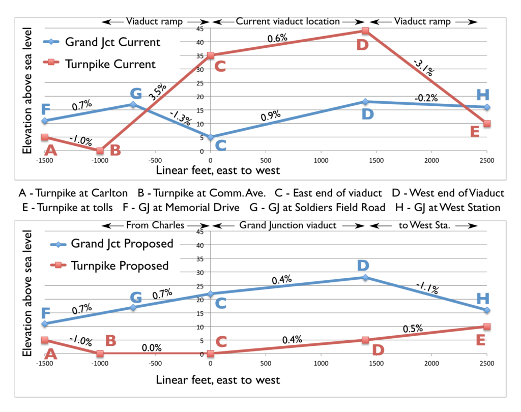
In the current setup, coming from Cambridge, the Grand Junction ascends to cross Soldier’s Field Road, and then descends sharply at a 1.3% grade to move under the viaduct. The roadway, on the other hand, ascends at a 3.5% grade to the viaduct, and then nearly as sharply at the other end to reach the toll plaza. This results in limited sight lines on the Turnpike. In the proposed Grand Junction viaduct, the ruling grade of both the road and the rail line is reduced; the rail line requires a 1.1% grade towards West Station (although this could be mitigated by slightly raising the elevation of the Worcester Line tracks), still better than the current 1.3%. And the highway has no grade steeper than 0.5% west of Comm Ave, where before it was seven times as steep, improving sight lines and safety.
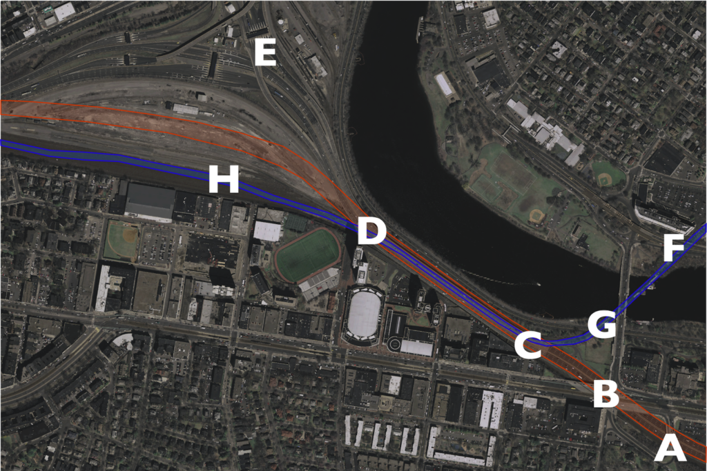
The charts below show the gradients for the current and proposed scenarios. The map below corresponds which each of the letters shown on the charts (data from MassGIS LiDAR data). Note how the Turnpike starts and ends at a lower elevation than the railroad. It makes no sense to have it resemble a rollercoaster.
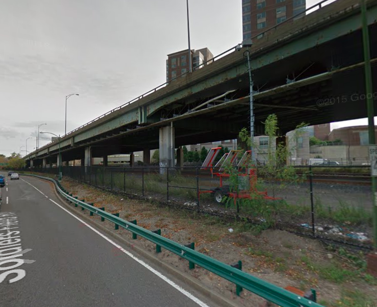
What we have right now is a half-mile-long, eight-lane-wide viaduct to cross a double-track railroad right of way. It’s as if a highway were tunneled under a small stream instead of going over it on a small bridge. For whatever reason, a highway viaduct may have made sense in 1962. It doesn’t today.
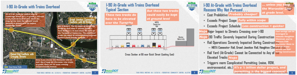
MassDOT “considered” elevating the railroad, but they dismissed it as infeasible. Why? Because they assumed that all four tracks of the railroad would have to be elevated. I don’t think it’s nefarious; I think everyone’s mindset is that the highway has to go over the railroad, because that’s how it’s always been. But the Worcester tracks stay on the same side of the highway as the whole way: they can stay at ground level; there’s no need for grade separation. The Grand Junction is much easier to elevate, and requires a much narrower structure, too. Here are three slides (from here) dismissing the overhead rail line as impossible, and my annotation on each as to why it is not the case. (Click here for full size.)
One issue is that MassDOT “requires” 135 feet of highway width for full-width shoulders. While this is “Interstate standard,” waivers can be granted for constrained areas, and much of the Turnpike (including the existing viaduct) doesn’t have any such lanes. If the highway is kept at grade, it will have much gentler grades and better sight lines. This added safety will mitigate the narrow width—and such a compromise would allow for better use of the corridor as a whole.
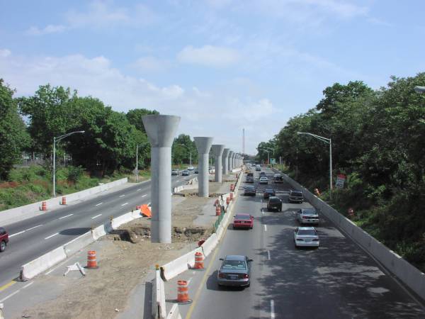
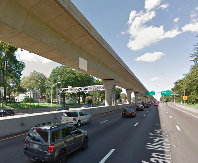
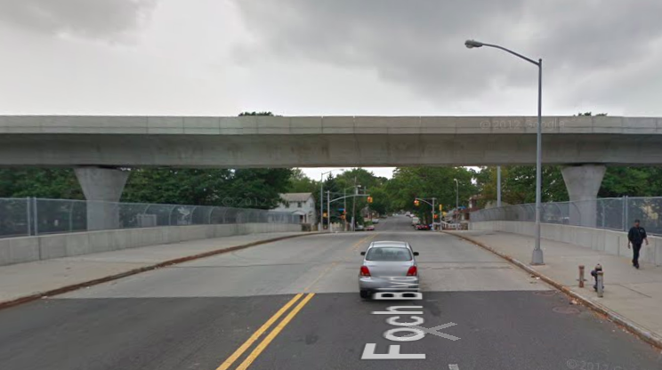
So you should kee the Grand Junction line high, and the highway low. Westbound drivers would cross under Commonwealth Avenue and then stay level. From their right, the Grand Junction line would ascend slightly—about 5 feet at a 1˚ grade—and pass on to pedestals over the center of the highway. It would continue down the center until it curved off to the left towards West Station and descended to grade. This is not a novel concept: the JFK AirTrain in New York operates in a similar manner in median of the Van Wyck Expressway. And since initial foundation work could be completed under the existing overpass early in the project, the bottoms of the pedestals and median could be pre-built with minimal impacts to traffic; less of an impact than shown here. One note: the AirTrain uses lighter vehicles than the Grand Junction, so it may require more closely-spaced supports and a somewhat thicker deck akin to what is used for other “modern” T bridges like the Eastern Route crossing of the Mystic River. (The photo on the right is of construction of the Van Wyck AirTrain, from this site.)
Which of the following is more inviting?
Since the AirTrain is elevated above cross streets as well, it’s quite a bit higher than a viaduct would be in Allston, what a cross-section would look like from the Paul Dudley White Bike Path is similar to what it looks like when it crosses a cross street. That’s a bit less obtrusive than this. Or see below:
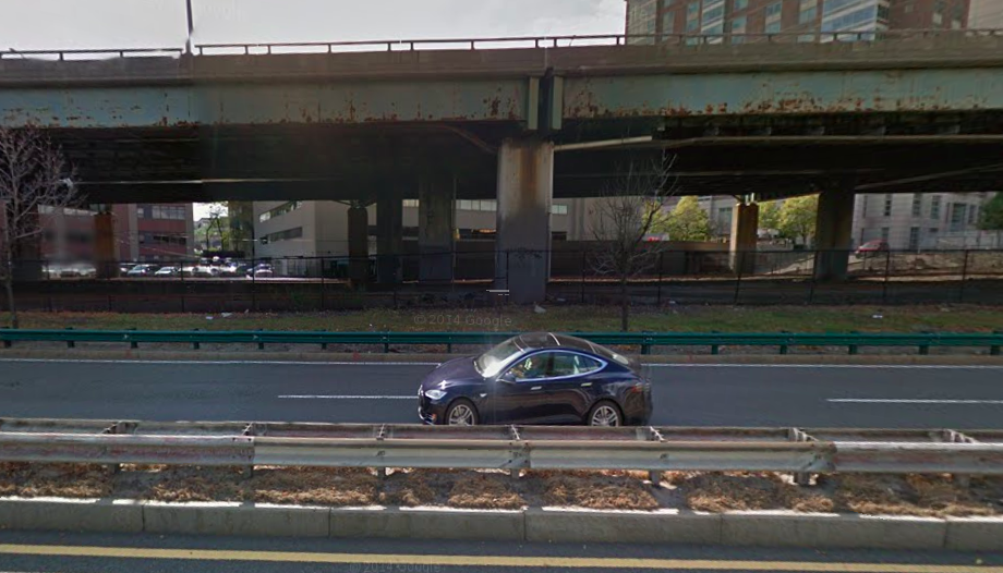
The photos above are actually taken from approximately the same distance away. Note how much more of the sky you can see above the Van Wyck. Wouldn’t you rather have something like the image on the right?
Not only is it one third the width, but it appears (and, in fact, is) lower for two reasons. In the nearby Prudential Tunnel, roads require about 14’3″ feet of clearance, trains 16’9″, so a road viaduct over a rail line is higher than the other way around. Second, trains don’t require guard rails. Put together, these add up to the top of the structure being six or seven feet lower for a rail structure. Much like how the Somerville Community Path is being built as part of the Green Line Extension, the “People’s Pike” path, it could cantilevered off the side of the Grand Junction viaduct (with additional support extending to the higher ground in—and connections to—Allston, if necessary). For an observer standing on the Paul Dudley White bike path, a rail viaduct in the median of the highway would be visible up to 6˚ in the sky, and 15˚ when a train passed over. By matching the initial grades, the highway can be lower than the Grand Junction since they don’t have to swap positions. The nearer and higher highway alternative would be visible in 20˚ of the sky, and 25˚—nearly a third of the way to vertical—when traffic is taken in to account. The smaller rail viaduct would cast many fewer shadows across the bike path and river as well.
Here is a cross section of my plans and the viaduct plan. Colors denote uses, and are scaled to the height of the users/vehicles. Scale in feet:
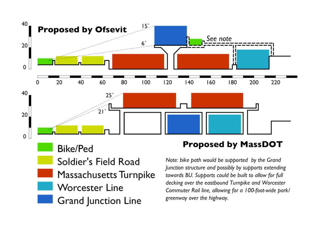
By elevating the Grand Junction, there is enough room for the rest of the uses:
- 14 feet for the Paul Dudley White path (an increase from 8 to 10 feet now, narrower in places)
- 24 feet for each side of Soldier’s Field Road, with a two foot median and two feet separating the bike path. This is the current width, and the road would need little modification overall.
- A four-foot barrier between Soldier’s Field Road and the Turnpike.
- 54 feet of travel space for each side of the Turnpike, enough for four twelve-foot lanes, a two foot left shoulder and a four foot right shoulder, with a six foot median where the supports for the rail line sit. Including barriers, this is 11 feet more than the current 107-foot-wide viaduct, although it is not as wide as the proposed MassDOT viaduct with full shoulders. However, by mitigating the steep grades and sight line issues, the road could be designed in this section with these narrower shoulders. With 11 foot lanes, an 8 foot shoulder could be accommodated.
- Six feet for the concrete pedestal supports for the box-girder structure for the Grand Junction rail line, which is 30 feet wide.
- 30 feet for the Worcester Line right of way, which would be relocated only slightly once the viaduct abutments are removed.
From above, it would look something like this (with just a sketch of ramps and street grid in Allston, which would built above grade):
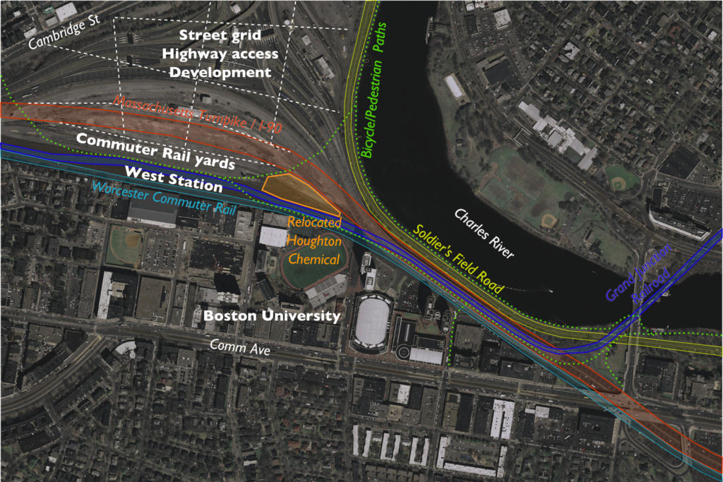
And a focus in on the narrow viaduct area:

It would also have benefits in the Allston area. In current plans, the Turnpike viaduct has to slope gradually down through the Beacon Park Yard area. If it were at grade, it could be easily decked over, and ramps could go up to a street grid on that deck. The Grand Junction would have to descend towards West Station, but it has a much smaller footprint and would start its descent from a lower elevation, thus it would much more easily integrate in to the surrounding area.
Construction would also be much simpler, because instead of a multi-stage process where the viaduct was unbuilt and rebuilt at the same time, it would simply be unbuilt in stages, with the new roadway built on the ground below. The current staging plans call for a new, wider viaduct to be built in stages, two lanes at a time, while the old bridge is being torn down, including many temporary supports and other engineering issues. By putting roadways at the surface, you could accomplish the entire task without building any new bridging, in fewer stages (dismantling four lanes at a time instead of two), and only shoring up a few supports temporarily. It’s even possible that pedestals for the Grand Junction—which would likely be built under the current viaduct before other construction—could be used during construction to shore up the viaduct as it is dismantled.
As for the final product, rather than a 110-foot-wide, 30-foot-high viaduct, you’d have a 30-foot-wide, 24-foot-high one. The rail structure would have just 22% of the mass of the road viaduct. Road noise would be lower to the ground (with the potential for an overbuild park to cap noise all together), and the viaduct would be further from the river and from buildings at BU. And ongoing maintenance costs would be far lower. The main loss is the inability to tuck some of Soldier’s Field Road under the viaduct and create slightly more parkland in the vicinity of the viaduct. But for a cheaper project, you get a much smaller viaduct which casts fewer shadows over this area, so the bike path is a more pleasant experience.
The only major issue would be a relatively long-term closure of the Grand Junction branch, so MBTA operations and a small amount of Everett-bound freight would have to move via Ayer and Worcester. This happened recently when the Grand Junction bridge was undergoing emergency rehabilitation for several months; the biggest issue was the 10 mph speed limit on Pan Am trackage between Ayer and Worcester. (The railroad out to Worcester is Class 3 and permits 60 mph speeds, the rebuilt railroad inbound from Ayer will mostly be Class 4 with speeds of 80 mph.) With a small portion of the money saved from not building a road viaduct, that track could be upgraded to Class 2 (30 mph) trackage to save considerable time with equipment swaps and improve a freight rail trunk line as well. It would also be an opportunity to fully rebuild the Grand Junction bridge, and other portions of the corridor to Kendall Square and beyond. (One other minor issue is serving Houghton Chemical, which could be accomplished, by relocating Houghton Chemical to the other side of the highway as depicted above. In the “armpit” of the Turnpike and railroad, it would be a perfectly good site for such a use, sustain a family business in the area, and free up developable land near the river.)
Once you take a step back from the current situation and think about this, it’s obvious. It makes no sense to build a wider, higher viaduct for a roadway when you can build a narrower and lower one for the railroad. All it requires is some grading underneath the viaduct, construction that is certainly no more complex that what is being proposed. A surface roadway has a much longer lifespan and lower maintenance costs than an elevated one, and it provides a much less obtrusive—and more future-proof, as it fits in better with potential development in Allston—structure as well. It’s a better project. Best of all, given the cost differentials for projects like the Casey Overpass elimination (and McGrath and Bowker), it could probably be built for $50 to $100 million less than the viaduct, with future savings from lower maintenance costs.
That money would go a long way towards full completion of this project, mitigation steps, and ensuring the safety of other roads and bridges across the Commonwealth.
This arrangement also has potential benefits for railroad operations, if the Grand Junction tracks can fly over the outbound Worcester Line track and end up in the middle between the two Worcester line tracks at West Station. Then the latter can be build either with three tracks and two island platforms so that you can have a cross-platform transfer from both directions to Grand Junction shuttles, or with four tracks and through-running from the west to the Grand Junction.
Yes and no. You'd have to depress one of the Worcester Line tracks significantly in order to fit it under the Grand Junction. Which is doable, of course.
I'm sold. Git 'er done!
Are E&H swapped on the map?
Uhm, yes. Good catch. Will fix.
Wow this is awesome. MassDOT should seriously consider it. The width of their proposed rebuilt viaduct is absurd. First of all, it should be designed for 55 or even 45 mph like the other sections of the Mass Pike in the area. Second of all, it doesn't need full breakdown lanes, because unless the rest of it through downtown gets a lane diet, that part won't either (there are some pull-offs though.) Their inability to design a highway for an URBAN setting is really quite disappointing. It's the same thing they did when they studied new ramps to/from Back Bay. They tried to jam long wide suburban-style ramps into an urban setting, and guess what? They don't fit! So frustrating…
I think some of their concern regarding breakdown lanes is the godawful sight lines along their alignment. At the Comm Ave end of the viaduct, you have a 3.5% grade, which is steeper than anything else on the extension. With no view lines, you have an issue where if someone breaks down another car could be on top of it with little warning, hence breakdown lanes. Build a flatter, straighter road, and you have better sight lines and less of an argument for breakdown lanes.
Schuylkill Banks seems to have put parts of their bike path on a bridge where waterfront land was unavailable.
Would moving the Charles River bike path onto a bridge over the river to free up land to be reallocated to meet the full Interstate Highway standards be worth considering here if MassDOT doesn't think an 8 foot outside shoulder with 11 foot lanes is good enough? (And what exactly is the major concern with 8' shoulder and 11' lanes?)
What are the concerns with landfill to narrow the Charles River by 10' to 50' to create more parkland and more land for the bike path, which seems like it might be the obvious approach if it doesn't have unacceptable environmental impacts?
Does the Grand Junction bridge really need to be built wide enough for two tracks in its initial iteration? Would there be any downside to building a smaller bridge for one track that could be widened for a second track later if there's ever a need for the second track?
That's certainly an option. If you depressed Soldier's Field Road, which only needs 10' or so of clearance, you could ramp up the path on top of it in the narrowest section without having to have it go up more than 8 feet or so. You still do need to cross the Grand Junction over the turnpike. Moving the path in to the river (or putting in fill) leads to a lot more environmental permitting issues (I believe the Army Corps of Engineers might even be involved); it's not like the '40s when they just built the lagoon islands to "compensate" for Storrow construction.
Why does the Turnpike needs 12 foot lanes and full shoulders? Hard to say. A waiver could certainly be obtained. This seems to be MassHighway nonsense. Given that you can have shoulders all through the toll plaza area, you can get away with no shoulders for a third of a miles.
As for the Grand Junction, yes, it does need to be built for two tracks. Otherwise you are building it for obsolescence. As I've written before, the Grand Junction is a fantastic link between North Station, Assembly Square, Sullivan Square, Kendall, MIT and Allston, linking together several Commuter Rail lines with the potential to provide massive last mile connections which don't exist today. (For example: currently it takes 1:04 to travel from Framingham to Kendall by transit, about as long as it takes to drive in rush hour traffic. A direct train via the Grand Junction would take about 35 minutes; even with a transfer it would only take about 40 minutes, saving those commuters an hour of travel a day and attracting many new commuters from the western suburbs away from their cars.) Building anything less than a full two-track right-of-way would lack the necessary scalability for the future that needs to be built to ensure that Allston and Kendall can be linked as necessary.
Splitting Worcester Line frequency with some trains going to South Station and others going to Kendall seems suboptimal if doing so makes achieving frequent service more difficult.
Why not have a frequent bus that originates at Forest Hills, mirrors 39 along South St, Centre St, S Huntington, then continues along Brookline Ave including a stop at Yawkee and another at Kenmore, then makes its way across the Harvard Bridge to Kendall? (I'm wondering if offering multiple routes with multiple destinations along the southern part of 39 would reduce the effect of everyone crowding into the first bus that comes.)
Or, maybe an organization with experience running shuttle bus service from a major commuter rail station to Kendall area office buildings could add service to Yawkee.
I think the key is not to split, but to have a transfer at West Station. Splitting would work with increased frequencies, which the line could probably support (especially if Cambridge—Kendall and Harvard—were more easily in the commute shed). Local and express trains could meet there and passengers could transfer to different locations, a very downscaled version of, say, how Jamaica works in Queens where people transfer between Atlantic Terminal, Long Island City and Penn Station.
That bus route makes empirical sense, but you have to get it across the river somehow, and the BU Bridge and rotary just don't work for that, especially in the evening when rotary traffic can cause 20 minute delays. Plus you have to get in and out of Yawkey Station, which is not really located in a straight line, so you wind up with a zigzagging bus. This might work in the less-trafficky morning, but bus operations with unreliable traffic become very difficult, especially if they are trying to meet train schedules. Add to the fact that buses don't work well for high-density, last mile links (they don't have the capacity to easily absorb 100-200 people). The Grand Junction railroad bridge is untapped capacity across the river. Even a DMU shuttle would serve this purpose well.
But rerouting the 39: this makes sense. I have a blog post simmering somewhere about this, but the basic idea is to do something with the 39 and 47 akin to what was done with the 63, 64, 66 and 86 in the late '80s. The 39 has two overlapping peak loads: one from downtown to Mission Hill/Hyde Square and another from the LMA to central and south JP. (Downtown to JP commuters are likely to use the Orange Line.) If the Hyde Square streetcar is built, this addresses the downtown-to-Hyde Square portion of the demand. The 41 could be extended to Forest Hills, and the 39 could run through JP to the LMA, and the across the bridge to Cambridge.
The 47 is a similarly cobbled-together line; no one really rides it through the LMA. The 39 could run through the LMA and take over the LMA-Cambridge portion of the 47. The Broadway-LMA portion of the 47 could be routed along Broadway in South Boston to provide a direct link from South Boston to the LMA. There's still the issue of traffic, but breaking long routes in to shorter segments makes sense.
If West Station were a transfer point with (from the AM peak perspective) an express train arriving at one side of an island platform and a local train arriving simultaneously at the other side of that platform, and they then would exchange passengers and one would continue to Yawkee / Back Bay / South Station and the other to Kendall, I suspect the dwell time with bi-level cars would be longer than is desired, which makes me wonder if I shouldn't have been so concerned with frequency. Also, IIRC one of Cambridge's concerns with Grand Junction revenue service was how fast and often trains would go through grade crossings; a plan with a limited number of trips through Cambridge might be politically advantageous among proposals for revenue service on the Grand Junction.
I'm wondering if building a side platform between Main St and Mass Ave, installing quad gates at Mass Ave and then operating revenue trains no faster than 10 MPH across Mass Ave would be a feasible approach to a minimal level of service.
Perhaps the first inbound train to Kendall of the morning, after dropping off passengers at Kendall, could head back across the Charles and take over train 507's slot (maybe the trainset at South Station which would otherwise use that slot could deadhead to the yard at Readville or something), and then the second inbound train of the morning, after dropping off passengers at Kendall, could slowly deadhead through the northern five Grand Junction crossings to spend the mid-day at Boston Engine Terminal.
http://amateurplanner.blogspot.com/2014/08/no-need-to-duplicate-transit-on-comm-ave.html?m=1 has a comment from Matthew claiming that, as of about a year ago, MassDOT was planning to rework the intersection at the southern end of the BU bridge; and it appears that construction at the northern end of the BU bridge is ongoing. Do we have any reliable data on whether or not traffic will be functional in this area when all of the construction is done?
Once West Station exists, a shuttle could serve it instead of Yawkee, but I'm not sure if any timeline exists for West Station construction.
You can perfectly well put 200 people into a pair of 60' buses if you know you need to have that pair of buses waiting empty when the train arrives. But when EZ-Ride has been running 35' buses on 8 minute headways at North Station, it's not obvious to me why the Worcester Line would be expected to require any more than that.
Potential routes on southern part of 39 corridor:
39 status quo
frequent, reliable service on the part of 41 to the west of the Orange Line
43, operated with battery powered buses, reverted back to the Pleasant St Incline with Park St as northern terminus, extended along 66 from Ruggles to Huntington, then mirror 39 the rest of the way to Forest Hills
to Kendall
to Central
to Harvard via Coolidge Corner and possibly Babcock St and West Station
Another possible variation:
At grade, from south to north:
30' Worcester Line to Back Bay Station
68' I-90 eastbound (2 x 10' shoulders, 4 x 12' lanes)
92' I-90 + Soldiers Field Road westbound, as a single 6 lane road with I-90 on the left four lanes and Soldiers Field Road on the right two lanes (2 x 10' shoulders, 6 x 12' lanes)
parkland + bike path
Then, build a viaduct above the full width of I-90 eastbound, and use the northern part of the top of the viaduct for Soldiers Field Road eastbound, the part next to that for the Grand Junction Railroad, and possibly include a bike path on the southern part of the top of the viaduct.
The 24' freed up by removing one direction of Soldiers Field Road from the at grade section doesn't quite provide the 2 x 14' I'm trying to include to get the full 10' shoulders on each side that Interstate standards want for three or more lanes in each direction, but it may be possible to squeeze that extra four feet out of narrower barriers between sections or the bike path.
(I'm not entirely clear on whether it really makes sense to have one bike path along the river and another on the viaduct; it seems like a bridge at the western end of the constrained section to connect the river bike path to West Station might go a long way towards meeting at least some of the goals of the bike path on the viaduct.)
The four feet isn't so much of a problem when you notice that two barriers vanish from the at grade section, saving 4' or 6', when you elevate one side of SFR and integrate the other with the Pike.
Houghton Chemical could be served by constructing a track that would pass under the Pike if you want to avoid the potential challenges of relocating the business.
If we assume a relocated SFR, eastbound I-90 could have an exit to the right which would duck under the Pike to connect to SFR northbound, and a freight spur could be constructed to duck under the Pike next to the exit ramp. Presumably space would need to be reserved for that extra track between the four platform tracks and the highway so that the freight spur would have space to descend adequately.
To clarify, when thinking of a relocated SFR, I'm thinking of
http://amateurplanner.blogspot.com/2013/11/allston-brighton-toll-straightening.html?m=1 and not MassDOT's proposal to relocate the road 20'.
Also, it turns out MassDOT is planning to put a rail yard between the platform tracks and highway, so the real key to making the grades work for a freight spur under the highway would likely be lowering the rail yard.
An alternative also worth exploring would be to design one of the MBTA's yard tracks so that it could store a commuter train at the mid day, and late at night it could unload tank cars into a pipeline that would run from the yard to Houghton Chemical; if that would meet Houghton's requirements, the relatively small diameter of one or more pipes may be cheaper to deal with than constructing an underpass large enough for a railcar.