
We recently wrote about the obscenely inflated cost of the Red-Blue Connector. And while the underground costs are certainly inflated, it still involves building a tunnel underground, in loose fill, under a busy street, and then building connections in to an existing station. It would still involve months- if not years-long lane closures, massive utility relocation, and underground station construction. It might be heretic to say so, after Boston has mostly removed above ground transit, but in this case, an elevated solution might be the best solution possible, and not just because it would be cheaper (which it would be).
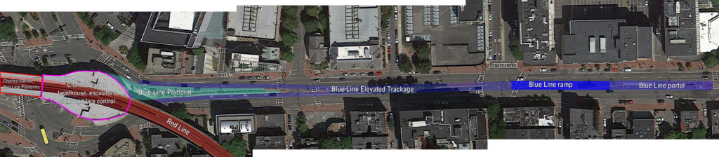
First, the logistics. The Blue Line tunnel currently ends several blocks east of Bowdoin Station. The original portal was between Joy and Russell Streets (at Nims Square, one of Boston’s lesser-known squares). Here’s an aerial photograph of the portal; you can see that it is several blocks east of the curve at Bowdoin Station. Most likely, the tracks were capped just east of Joy Street, and the portal filled with dirt and built over. Most likely, it still exists.
And most likely, it could be easily opened. The cheapest option would be to run the Blue Line straight down the center of Cambridge Street at grade, but for a litany of reasons that, uh, wouldn’t work. But instead of coming up from underground and flattening out, it could continue sloping upwards and, by Blossom Street, enter an elevated guideway above Cambridge Street. From there, it would continue a few hundred feet and terminate at a two-track station with a center platform above Cambridge Street, adjacent to the current Charles Station.
Click the diagram below to enlarge. All lines are to scale.
There are many, many advantages to an elevated solution. They include:
• The portal exists! There may be some utilities buried there, but not likely major infrastructure; it’s probably mostly just fill.
• The portal is built in to the side of Beacon Hill. As the tunnel rises to the surface, the surface falls away. This limits the space that a ramp takes up for the transition from underground to elevated. In addition, because the Blue Line does not require overhead wiring, the tunnel height is lower—and therefore the floor is higher—reducing the amount of climb necessary. A similar subway-to-elevated transition exists for Green Line trains between North Station and the Lechmere viaduct. The distance between the portal and where the viaduct passes over the ramps from the Leverett Circle is conveniently the exact same distance as from Joy Street to Blossom Street on Cambridge Street.
• Once above the street, the viaduct will be quite narrow. Since the East Boston tunnel was originally built for streetcars, Blue Line cars are narrower than, say, Red Line cars. The elevated portion of the Green Line between North Station and Lechmere—especially the new section east of Science Park—is a good guide to the width, although with no need for overhead wire, a Blue Line viaduct could actually be built narrower than the Green Line.
• Charles Station could be built to serve the Blue Line with no added mechanical equipment, and minimal changes to the station. There are already wide stairwells, escalators and elevators in Charles Station which bring passengers from street level to the Red Line. The Blue Line would simply be a platform accessible from the current outbound platform, and would not require any additional infrastructure. Unlike other transfer points in downtown Boston, Charles Station was recently rebuilt, and passages are wide enough for significant additional traffic. An underground station, with additional elevators and escalators
• An elevated Charles Station would require transferring passengers to climb and descend fewer stairs than an underground solution. Imagine a round trip from Cambridge to East Boston. For an underground station, passengers would arrive on the Red Line, descend to street level and then down to the underground, reversing the trip on the way back for a total of four flights of stairs. For an elevated solution, the morning would require two flights—down to street level to cross under the Red Line and then back up—but the evening would be a level transfer, halving the vertical distance each passenger would have to travel.
• While Cambridge Street abuts the historic Beacon Hill neighborhood, it is generally bordered by newer construction, and in many cases by parking lots. The street runs east-west, so most of the shadows cast by an elevated structure would fall on the north side of the street, which is mostly occupied by Massachusetts General Hospital, and in several cases by parking facilities. As a major beneficiary of the project, MGH would likely be willing to have some shadows cast in exchange for far better accessibility. In addition, Cambridge Street already has an elevated structure at Charles Circle, so it is not an entirely new concept to have overhead transit in the area.
• A fire station would likely have to be relocated from the south side of the street between Russell and Joy Streets as they would no longer be able to take left turns across the subway-elevated transition. However, it could be moved to parking facilities on the other side street near MGH, and integrated in to new construction. For instance, a fire house occupies the ground floor of a skyscraper in the Financial District.
• Elevated construction and stations are far less expensive to build than underground. And far less distuptive. While an underground structure would require years of lane closures on Cambridge Street, an elevated structure would require only supports to be built in ground—and those would be in the median. Most of this work—exploration, utility relocation and the pouring of the concrete—could take place outside of rush hours, and the actual viaduct could be built off-site and placed on the pedestals, with minimal interference with local traffic. If the area can survive a three-year closure of the Longfellow Bridge, it could deal with a few short-term lane restrictions.
At $100 million per mile, the elevated section would cost less than $50 million to build. Since the station would be little more than a concrete slab between two tracks—no need to install multiple elevators, escalators and fare control—it would not appreciably add to the cost. It’s entirely possible than an elevated solution could be built for under nine figures, far, far less than the state’s estimate for an underground connection.
• This project would require few—if any—property takings. The only street-level construction would be supports for the elevated, and these could be built in the existing median on Cambridge Street. Again, the supports for the Green Line connection between Science Park and North Station is a good case study; the base of the concrete pedestals are only five feet wide.
Building a Red-Blue connector is something which would dramatically enhance Boston’s transportation network. It would increase ridership, reduce congestion downtown, and provide better employment access for a large part of the area. It would also utilize the only portion of the downtown network which is under capacity—the Blue Line—and allow it to better serve the traveling public. And while the state may be set on inflating the price to high that it will never be built, a compromise solution using as much existing infrastructure as possible could be built more quickly and far less expensively. It is a solution the city and state—and stakeholders in the area—should seriously consider.
Interesting possibility but there's a few problems. Putting aside Boston's fear of El, the most striking issue I see here is the unavoidable stub-end terminal. This plan would preclude any extension of the Blue Line beyond Charles. And it would create permanent operational difficulties.
I think that in general it's best to avoid having a terminal station without tail tracks. The little escalator-climbing incident in Chicago is a good reminder. Also the tragic accident in Brazil last year. When the tracks end like that, the trains have to enter the station very slowly, creating a TPH bottleneck that in this case would be completely unfixable in the future. Maybe the Spanish or the Japanese could manage it safely and efficiently but I'd much rather we have tail tracks.
And then yes, no extension to the riverbank, or Kenmore, or anywhere else in the future. I know those are pie-in-the-sky but official plans did leave the possibilities open. Red/Blue alone isn't going to balance the Blue Line nor use up the downtown capacity.
A riverbank extension won't happen. Really ever. You'd have to dig up Storrow Drive, put in a tunnel, and then put Storrow back in on top (or get rid of it), you'd be tunneling in fill below the water line, so it would be costlier to maintain, and the riverfront is not where more transit is necessary. If you want to increase transit options west of the city, the two-track main line of the Worcester Line combined with the Grand Junction give you much higher capacity and serve more highly-populated areas. Plus, the cost of that would be pretty astronomical. If you are going to spend $3b on something, spend it somewhere else.
Hell, it would be a better plan to extend the Blue Line across the Longfellow and somehow have it share stations with the Red Line out to Harvard (and cheaper, too).
Are stub-end platforms perfect? No. But the underground plans would have been the same construction of a stub-end platform, so I can't see how that would have been any better safety-wise (and with proper design, a Chicago-style escalator climb shouldn't be a reason not to build infrastructure). As far as capacity, if there were issues during rush hours with trains operating at low headways, some Blue Line trains could use the existing Bowdoin loop to turn back, much like some Green Line cars are turned at Park Street when there is congestion ahead.
And, no, Red-Blue is not a panacea for all that ails the T. But it would dramatically increase the utility of the system and at the same time pull some of the transferring passengers out of the core, and all for a price tag far less than the state has said it would cost.
I shouldn't have mentioned riverbank. That's a distraction. Don't need an extension to justify tail tracks.
Fact is, the underground plans do include tail tracks, and it makes operating the line much easier and smoother for everyone. Being able to pull into the platform at full speed makes a big difference to connecting passengers.
A stub end design without tail tracks will limit capacity, reduce options in case of a failure, and result in more use of the Bowdoin loop, assuming that is maintained. That situation is far from ideal. Use of the Bowdoin loop undermines the whole reason for building Red/Blue.
Yes, operating a line without tail tracks does reduce capacity. For example, the Waterloo and City line in London can't really run more than 22 trains per hour due to the lack of tail tracks. For comparison, the Blue Line currently runs 14 trains per hour and uses a trainstop system almost identical to the one used in London for train protection. And in London, they're pretty cautious about trains not overrunning the end of the track after a rather bad crash at Moorgate in the 70s.
So while it would be nice to have tail tracks and an underground station, the Blue Line isn't that pressed for capacity, and I think the elevated option is still very workable if it really is that much cheaper. Because that means that it might get built 30 to 50 years earlier than it would otherwise.
I agree with arcady. Sure, a stub-end station is not perfect (a loop would be great, but we can't really build that out over the Charles) and tail tracks mainly only allow the trains to enter the station more quickly. As a coworker pointed out, it's a half mile trip from Government Center to Charles, give or take. If you keep the curves at Bowdoin, that means that you really only have a few hundred meters to get any kind of speed. Restricting the trains to 30 mph until the portal and 20 thereafter would add seconds to the trip, and a hard speed limit of 10 mph at the platform end would mean it would take 20 seconds to pull in to the station. So maybe you lose a total of one minute of running time overall. Considering the current trip with two transfers takes 15 minutes and this would take 5, it's still a major savings.
And, no there's not really that much of a capacity constraint. The Blue Line runs six car trains now, which is twice as long as a two car Green Line train (with level boarding to boot). The cars are certainly smaller than, say, the Red Line, but the line is not particularly capacity-constrained. Keeping the Bowdoin loop allows for some operational flexibility should something occur at Charles and, say, only one track be available (a disabled train, for instance). Some trains could be short-turned at the Bowdoin Loop, allowing service to be maintained along the main part of the line during times of frequent headways.
This is much like how Park Street is used during rush hour service. If an inspector finds that a train is running behind schedule, they'll shunt it on to the fence track and have it turn at Park. The passenger disruption is minimal other than crossing the platform and getting on a train a couple of minutes later. Turning the train means it is less likely that service gaps will form and trains will bunch and become overcrowded, in theory, at least. How this would play out on the Blue Line to Charles: let's say that due to dispatching or some delays, three trains (A, B and C) came in to Government center at 5:00, 5:03 and 5:05. If all continued to Charles, the last train would have to wait a couple of minutes for the first to reverse, and might interfere with the second train's departure, cascading delays further. So, train A continues to Charles. Train B terminates at Bowdoin and loops back for the outbound run. Train C picks up train B's passengers, who only have a two minute delay, and continues to Charles. Use of the Bowdoin Loop allows you to maintain good service on the rest of the line due to any constraints a stub-end platform may require.
Perhaps something like the electric trains that shuttle between North and South Terminal at London's Heathrow. That is, instead of using the regular Blue Line cars, use a light-weight two-train system that just shuttles between Charles and Government Center. Yes, people would have to depart at Government Center to connect with the real Blue Line, but electric shuttle trains of this sort don't need tail tracks, and can even be completely automated.
You've been playing too much Mini Metro? Any time you add shuttles, you're adding a ton of complexity. Where do you service these shuttles? Where do you store extra equipment? Etc.
How much would it harm the operating efficiency to make the elevated part a single track? My guess is, not much, and I suspect that would further shrink both the cost and the impact of the elevated line.
A lot. The Blue Line runs every 4.5 minutes or so right now. Given a travel time of one minute along the single track to and from the station, the margins start getting pretty tight, since you have 2.5 minutes of turnaround time at most, and it probably takes some 2 minutes to shut down the train, walk down its length to the other cab, and prepare to depart. If they use "stepping back", where the train gets picked up by the operator from the previous train, the margin is a little better, even giving a little bit of recovery time, but it would likely be the main constraint on Blue Line capacity at that point, unless you could turn half the trains around at Bowdoin.
And you're assuming a best-case scenario where trains on 4:30 headways actually come every four minutes and thirty seconds. Even minor bunching would result in several minute delays as the fastest turn-around you would have would be 3:30 or 4:00. Even two tracks is pushing it which is why I'd be a proponent of keeping the short turn at Bowdoin. One track may work at the ends of some light rail systems (Denver, Sacramento) but not in this case, especially at a transfer station.
I really like this idea, but I would tweak it just a bit, so that the tracks split approaching the station so that each stub end aligns next to the same directional track on the Red Line. This would allow for the opportunity of building a cross platform connection, but more importantly, it leaves an option for extension. By building flying junctions past the platform, the trains could then cross the Charles via shared Longfellow tracks. As the RL trains dip bellow, the BL trains would elevate above Main St., continuing a short distance to link up with the Grand Junction ROW. It could continue there on a viaduct abov the GJ tracks, for an eventual extension along the Worcester ROW.
You're assuming people would be fine with an elevated across the Longfellow (unlikely) and through Cambridge (also unlikely). Heck, Cambridge gets their panties in a knot when you propose more transit service on the Grand Junction. This will smell of inner belt and would never happen. I'm all for designing something in to this plan to allow for eventual extension of the Blue Line (where? not sure), but this would dramatically increase the cost. As for the cross-platform connection, it would require a higher and longer structure, which would cost more and piss off the neighbors more, neither of which will fly.
Don't run trains half a mile: build an enclosed, elevated moving walkway. Three, preferably, so that you can use 2:1 in rush hours or have one out for service. At 6 MPH you have a five minute journey, ADA compliant, no scheduling unpleasantness, less moving mass.
This is an interesting idea. You'd need vertical circulation out of Bowdoin, and then the walkway would have to descend a grade downwards. Although you could have a mid-block entrance. 6 mph seems mighty high, though; I'm not sure that's feasible. It certainly is somewhat less of a transfer penalty than a double-change, but 6-8 minutes with an elevator ride and a long walkway ride is quite long.
The concept of connecting the Red Line and Blue Line has always struck me as a great idea, but the cost and logistics of connecting the Blue Line's Bowdoin Street Station to the Red Line's Charles Street Station (whether by extending the Blue Line to Charles Street or using a pedestrian moving walkway – either above or below ground) seemed beyond reach financially for the City of Boston and the State. Since the initial idea was to have a connection between the Blue Line and Red Line, I was thinking that making an underground pedestrian passageway that directly connected the Governmnet Center Blue Line station and the Park Street Red Line station would also achieve the same objective, at far less cost and disruption. Such a connection would be similar to the already-existing underground walkway that now exists between Park Street and Downtown Crossing that allows for a direct pedestrian connection between the Green Line at Park Street and the Orange Line at Downtown Crosing. Ideally, a new underground pedestrian walkway between Park Street and Government Center could have moving sidewalks and skylights built into the overhgead pavemen and sidewalks – and could be easily built at a fraction of the cost of connecting the Bowdoin Street Station and the Charles Street Station. In addition, it would allow Park Street to become a "super station" with direct connections to all four transit lines (not counting the Silver bus line).
That's a great idea (I've thought of it myself). In the Paris Metro, stations that are close to one another but whose lines do not actually intersect, are in some cases connected by a moving sidewalk which get you there quickly and easily. If you don't like the moving sidewalk, you're free to walk on a parallel stationary walkway.
Google Maps seems to think the northern end of the northbound Downtown Crossing Orange Line platform is less than 200' from the southern end of the southbound Orange Line platform at State St, so that may be a cheaper place to build.
Today the state EPA is attempting to kill the requirement to build this extension. This connector was part of the Big Dig environmental mitigation. Please contact arnold.anne@epa.gov with your obejctions.
Good idea.
A thought: what if the ramp climbed enough that the Blue Line platform were built on top of the red line platform? This would make for a single stair climb to transfer in either direction (or even a wide ramp between levels, as in Grand Central), and would mean that it would not be impossible to extend the tracks beyond the station if desired.
****WARNING DO NOT ATTEMPT WHAT I DID IN 1982-1985. IT WAS DIFFERENT WORLD BACK THEN. THERE WEREN'T MANY "T" COPS AROUND THEN AND IF WE GOT CAUGHT THERE WAS A 99% CHANCE WE'D GET YELLED AT BY A "STARTER" OR INSPECTOR AND TOLD NOT TO GO DOWN THERE AGAIN. A LOT OF THE "T" EMPLOYEES ASKED US IF WE EVER CAME ACROSS ANYTHING GOOD OR INTERESTING. WE SHOWED THEM OUR SYSTEM MAPS PICKED UP AT THE TOKEN BOOTHS AND OUR HAND WRITTEN NOTES TO SHOW THEM OFF.
IF YOU WERE TO DO THIS TODAY POST 9-11, YOU WILL BE ARRESTED! THE AUTHORITIES WOULD DEFINITELY LOCK DOWN THE BLUE LINE AT THE LEAST, THE WHOLE SYSTEM AT THE MOST. YOU WILL BE TREATED AS A HOME GROWN TERRORIST AND BE ENDLESSLY INTERROGATED AND FINED BIG TIME. YOUR DEFENSE AS TO WHY YOU WERE DOWN THERE TO SEE HOW WORK WOULD BE NEEDED TO CONNECT BOWDOIN AND CHARLES/MGH WON'T WORK.
SO THERE, I GAVE MY WARNING, DON'T DO IT. THE THIRD RAIL IS ALIVE DOWN THERE AND THERE MUST BE CAMERA'S. YOU WILL ARRESTED BY MEN IN BIG BLACK SUITS AND KICK THE LIVING SHIT OUT OF YOU!!!!!
The tracks are already there. When I was a teen, a couple of friends and I took some flashlights, Orange Vests and Hardhats and explored many MBTA Subway Tunnel. The Boylston Loop, Old Court Street Station near GVT. CTR. (We found a entrance next to the old Boston School Committee Building.) Down at Bowdoin, we climbed down onto the tracks and walked the loop. Back in those days you could stay on the train when it did the turn around and that was when we saw the tracks. This was the early 1980's. We walked down the tracks. It seemed pretty long, we walked until we came to a wall. We Had no Idea where we were. There were 2 emergency exits, we went up one and listened. We heard street sounds and people. When we hit the crash bar to open the exit, we hoped we weren't in the middle of commercial street or someone was standing on it. We held on to the door so it would not fly open and found ourselves on the sidewalk near Joy Street. and reset the door and shut it. We were thought we were less than a 1/4 away from Charles/MGH. Perhaps 2/10ths of a mile.