Massachusetts has taken on a surprisingly progressive role in transportation policy in recent years, with the transportation secretary publicly stating that “we will build no more superhighways” and setting explicit goals for a shift away from single-occupancy driving. As part of this fix-what-we-have policy, the state is planning to convert the whole of the antiquated tolling system to open-road tolling, eliminating toll boots and charging vehicles based on transponders and license plates. This is a good step forward as it will not only reduce congestion at toll booths but also reduce the amount of land required by the serpentine ramps and plazas needing at Turnpike entrances and exits. While rural interchanges won’t be changed, it give the opportunity to rework a lot of urban land previously occupied by redundant roadways.
 |
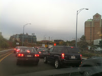
| Typical traffic. |
The Turnpike-Cambridge/River Street-Soldiers Field-Western Avenue interchange is a royal mess. It is so confusing that the state long ago stopped maintaining lane markings, and today it is a free-for-all as vehicles jockey for position as ramps funnel in to each other at a series of lights. For bicyclists and pedestrians? It’s a nightmare. Coming east on Cambridge Street is nearly impossible through the traffic chaos, and even crossing Western Avenue and Cambridge/River Street on the Paul Dudley White Bike Path is difficult, without a specific bike/ped cycle, crosswalks, curb cuts or even, at the southern bridge, a walk light!
A bit of a radical idea here that I’m proposing would be to move Soldiers Field Road away from the River. From Boston to Watertown, nearly the entirety of the Charles River is lined by highways. Yes, there is a bike path squeezed in between the riverbank and the roadway, but it is clear that cars are given the priority—we’ve turned our back on the river. The bike path is narrow, and when it intersects roadways crossing amidst the turning vehicles, it is perilous. It is a poor excuse for bicycle infrastructure, yet it is quite heavily used. Added to this, Soldiers Field Road doesn’t even follow a straight line but hugs the riverbank, adding distance (and pollution) for motor vehicles.
Here, then, is a conceptual plan to both improve the Turnpike interchange and the connection between the Turnpike, Soldiers Field Road, Western Avenue and River Street. Just doing the first part will still result in backups, congestion and pollution, and do nothing to improve the lot of pedestrians or cyclists. This plan would improve conditions for all users, and while it would require a major buy-in from Harvard University (which owns the land Soldiers Field Road would be rerouted across), they would be given a major incentive: an Allston campus connected directly to the river (in fact, some of their long-range plans have included decking over part of Soldiers Field Road). Depressing and covering the road would be simple compared to many similar projects (i.e. the Big Dig) as it runs almost entirely through post-industrial brownfields and athletic fields, no major property takings or utility work would be necessary, and much of the route would be closed to trucks, meaning the road clearance would only have to be big enough for emergency vehicles (and, perhaps, transit buses).
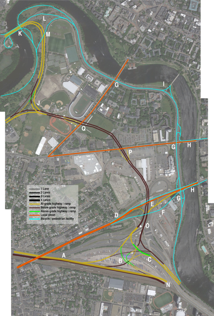
I’ve annotated the map, each letter corresponds to a comment below:
 |
| Click to make big! |
A: The eastbound Turnpike main trunk would be depressed below the westbound trunk, allowing ramps to overlay.
B: A single westbound ramp would allow access to Soldiers Field Road in both directions, as well as River Street in Cambridge. Western Avenue would be accessed via Soldiers Field Road. Note that if Soldiers Field eastbound were merged with the Turnpike (see below), these ramps would be mostly below-grade; it could be built to allow that sort of conversion at a later time.
C: Soldiers Field east mainline. These roadways, and the ramps on and off of them, would not require truck clearances (but would require clear “no trucks” signage).
D: Cambridge Street could be narrowed to 4 lanes, and narrower yet between ramps. Sidewalks and cycletracks could be elevated to avoid ramp entrances and exits. Traffic from Western Avenue to Cambridge Street via Memorial Drive.
E: Offramp to Cambridge Street would end at a traffic signal.
F: Elevated cycletrack / sidewalk allows cyclists to avoid traffic signal and on/off ramps.
G: River bike path built 12+ feet wide, utilizes one of the disused Soldiers Field underpasses to avoid grade crossings. This would allow a 8-mile traffic-free trip from the Charles River dam west to the Western Avenue Bridge in Brighton by foot or bicycle. The other side of these underpasses would be filled.
H: Separated cycletrack facilites on the Western and River/Cambridge bridges would connected with the grade-separated riverside bike path. The riverside path could be set back from the riverbank, which would be maintained for active and passive recreation.
I: Rebuild the Weeks Bridge with ADA accessibility, and connect to bike paths for a river crossing.
J: The connection between Soldiers Field Road and the Eliot Bridge would be grade-separated; the current connection has a three-phase light in the center. Another option would be a single-point light between the Soldiers Field East-Eliot Bridge and Eliot Bridge-to Soldiers Field East which would reduce grade separation.
K: The current underpasses under the Eliot Bridge for bicyclists and pedestrians would be retained. Sidewalks / paths on the bridge would be used for grade-separated access to south-side pathways.
L: Most of the intersection east of the Eliot Bridge would be rebuilt as a wide swath of parkland.
M: A bicycle bridge would be built across the Eliot Bridge connection, cutting some distance off this route. Grade-separation would be integrated with the Eliot Bridge, and the current Eliot Bridge underpass would be retained (K).
N: Ramps to the current elevated structure would be built not to preclude future grade separation eastbound.
O: Mixing zones on Soldiers Field Road would be three lanes wide, and long enough to allow traffic to merge across two lanes to access various routes (although engineering would be required to determine the optimal length here so as not to bottleneck).
P: Ramps to Western Avenue would be built to specifications for truck traffic; north of this it would be cars-only. Traffic destined to Harvard Square would be routed west on Western and then east on Harvard, or via Memorial Drive.
Q: Ramps at North Harvard Street would be offset to keep construction away from Harvard Stadium. The track would be reoriented after construction.
While adding Soldiers Field Road reconfigurations to the rebuilding of the Turnpike interchange, the project should still not be viewed in isolation but rather as part of the larger transportation network. A few things to consider:
- Allowances should be made for future fixed-guideway transit between BU and Harvard.
- The entirety of the Turnpike, the railroad tracks and as many ramps as possible could be buried to allow the street grid to be connected across the rail yard from the BU area towards the river.
- Instead continuing east along the river, Soldiers Field Road could merge in to the Turnpike. This would require a wider highway (perhaps five lanes in each direction) and require the highway to be rebuilt below-grade to allow for room for the rail line. It would probably also necessitate some sort of exit in the Charlesgate area. This would be moving towards Big Dig territory as far as complexity, although by moving all rail service to North Station via Cambridge on the Grand Junction, enough space could be freed up to phase construction along the Turnpike. It would, however, create a three-mile-long section of riverfront with no roadway between the city and the river. (Paul Levy made this point years ago.)
- The Grand Junction, if (3) were built, would have to be fully rebuilt, below grade and with a transfer station at Kendall Square, although this would be a dramatic transit enhancement for the region and worth the investment.
- If Soldiers Field Road and Storrow Drive beyond it were replaced, it would recreate the parkland which James and Helen Storrow originally intended along the river. A two-lane parkway-type road could be retained from Charlesgate (which would have the Bowker Overpass flyovers removed) eastward (although this, too, could be in a tunnel) with a wider roadway resuming only past the current tunnel near the Hatch Shell towards Leverett Circle.

Could there be a transitway median in the relocated SFR between N Harvard and West Station, with the transitway having an at grade intersection with N Harvard, and platforms at appropriate points along the way?