 |
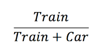
| In case of confusion: this is what I am calculating here. |
There seem to be misperceptions as to how many people Commuter Rail carries in Boston. So I decided to calculate how much of the capacity train lines carry compared to the total number of people traveling in the corridor (by rail and highway), to get a sense of how important the rail lines is to the overall transportation network. 33% would mean twice as many drivers as rail passengers, 50% would mean the same amount on the road versus the train. To put it another way: if everyone on the train drove, would traffic get a little worse (15%), or a whole lot worse (50%)? To put it another: if the trains were faster, more frequent and more time-competitive with driving, how much of a dent would it put in traffic, or, at least, how much increased capacity could it account for?
How did I do this? I took the CTPS train count data and calculated, for each line, the number of passengers arriving during the single peak hour of service (generally 7:30 to 8:30). For each highway or major road leading in to the city, I looked at MassDOT traffic data and calculated the number of cars coming in to the city for the same peak hour. The I grouped these together in to corridors and compared the results. (It turns out that Alon took a quite different methodology, and came up with similar results.)
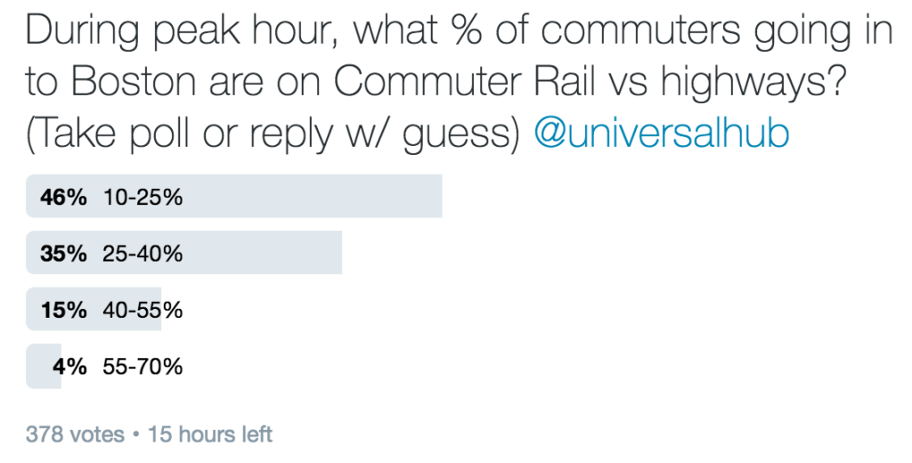
What are the results? Well, before I took the results, I took a poll on Twitter to see what people think the results would be. The poll is kind of braindead and only allowed for four options, so I put in a range from 10 to 70% in increments of 15% (the answer falls somewhere in this range). If you haven’t seen this poll already, go ahead and vote: [note 1]
During peak hour, what % of commuters going in to Boston are on Commuter Rail vs highways? (Take poll or reply w/ guess) @universalhub— Ari Ofsevit (@ofsevit) March 1, 2017
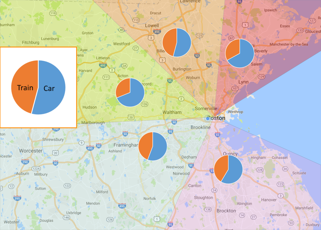
The correct answer? From my data, and supported by Alon’s, it’s about 42%. [note 2] So about 80% of people are underestimating it. I can see how this happens. Good infrastructure looks empty. The Providence Line north of Hyde Park may only have a train every nine minutes, yet it carries more people than a jam-packed, four-lane highway. [note 3] If you sit on the Turnpike in traffic for half an hour you may only see one train roll by (never mind the fact that train is carrying several miles worth of traffic [note 4]).
Now, 42% is low. Mode share is much higher in New York and Chicago. [note 5] This means that Boston’s lines have room to grow with better investment, which is why we need a long-term vision for the rail network and need to make sure that projects like Auburndale don’t go awry and permanently crimp capacity.
| Corridor | Road | Rail | Highways | CR Lines |
| Northeast | 5956 | 2936 | 1, 1A |
Newburyport, Rockport |
| North | 4647 | 3937 | 93 | Haverhill, Lowell |
| Northwest | 3966 | 1792 | 2 | Fitchburg |
| West | 8385 | 6646 | 90, 9, VFW |
Worcester, Needham, Franklin |
| South | 12025 | 8498 | 95, 28, 138, 3A, Granite Ave |
Providence/ Stoughton, Old Colony |
Or, graphically:
Note the dip after 7 a.m. As traffic increases and speeds decrease, both in this segment and downstream, congestion actually decreases the throughput of the roadway. There’s no more room to put cars. And this occurs on most major highways in the region. If we were to drop Commuter Rail passengers on to the highways, it would be cataclysmic. Maybe in 1969—when highway volumes were a third of what they are today—Commuter Rail seemed like an antiquated concept. Even with the old, tired infrastructure the MBTA operates, that’s not the case today.
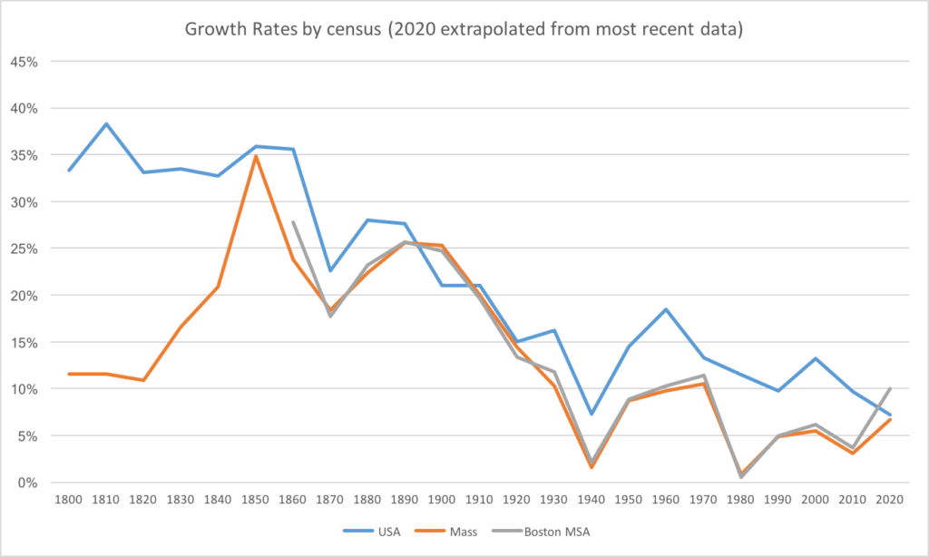
We’re not about to build wider highways (it’s expensive and doesn’t work anyway). But the region is growing: for the first time in a century the population of the Boston area is increasing at a rate faster than the country as a whole:
 |
| This chart is actually quite amazing. (no data before 1860 for the Boston MSA) |
The highways are full. The subway is close. The railroads have capacity, and they link downtown to many regional centers with more available housing. They’re over-utilized compared with our perceptions but under-utilized compared with their potential, and other Commuter Rail lines in other cities. From the lows of the 1970s, the lines were upgraded in the 1980s, and ridership responded. Since then both planning and ridership have stagnated. As the region grows we need a better plan for our rail assets now, and for the future.
Note:
General note on data: This is counting only people on highways and other major roads and Commuter Rail. Think of it as anyone coming from outside 128 (or outside the reach of the Rapid Transit system) to the Downtown area. There are certainly some people who take back roads that whole way, but they are probably a relatively small number in comparison. There are about 412,000 jobs based in Downtown Boston plus Seaport, Back Bay and Fenway, and maybe another 50,000 in Cambridge. This is only during peak hour; off-peak travel—when train schedules are limited and roads clearer—are likely much more car-dependent.
Note 1: As of the posting of this blog, the votes broke down as follows and have been stable in this range for several hours:
Note 2: This is a coarse, broad measurement. For certain towns with relatively good rail service and poor road connections—Attleboro/Mansfield/Sharon, Acton and Salem come to mind—the Commuter Rail mode share is likely much higher.
Note 3: Of course, the Metro-North Park Avenue viaduct carries 47 inbound trains between 7:30 and 8:30 a.m., probably carrying upwards of 40,000 passengers. You’d need half a dozen eight-lane highways to carry that many people. Some New York subway lines carry nearly double that, but over shorter distances.
Note 4: The heaviest train on the Worcester Line, train P508, carried 1179 passengers in 2012; reports are that it’s closer to 1500 today. A dense traffic jam may have one car every 30 feet, or 176 cars per lane per mile, or 528 cars on a three-lane highway, so two miles of traffic wouldn’t even cover all of P508. A well-patronized train, in other words, carries about as many people than a traffic jam from Newton Corner to Auburndale. Highway capacity is quite finite.
Note 5: In Chicago, for example—perhaps a better comparison since parking is cheaper than in Boston and freeways provide better downtown access than New York—Metra’s BNSF line carries 60,000 passengers per day. At rush hour, there are 15 trains carrying upwards of 11,000 passengers per hour, more than the parallel Eisenhower and Stevenson freeways combined (and another 6000 ride the UP-W line in the same catchment area). Metra’s busiest station, the gargantuan Route 59 park-and-ride, generates as many as 1000 people per train, and there’s a train every 20 minutes at peak rush express to and from the city. Note that unlike the MBTA, the park-and-ride is in addition to, not instead of, downtown stations in nearby Naperville and Aurora.


One thing I'm sure you know but which you didn't say explicitly is that the traffic congestion is non-linear, so that if 40%-plus is train capacity, that's way more than 40% of traffic congestion. I remember a recent state that Joe Cortright used that said that a 3% reduction in VMT in 2007 led to a 30% decline in traffic jams.
In addition to capacity increases, I also wonder what can be done to augment this by improving biking. I say biking rather than walking because these commuter stops are in suburban areas that aren't by nature terribly dense. They could become dense over time, but that requires the faith on the part of public officials that new development is likely. On the other hand, while we're waiting for areas to densify around these train stations, we could be making parts of the town out-of-range of walking (1-3 miles) more accessible to the stations, with pretty modest investments in protected bike lanes and bike paths. I think the feeder effect of increased access would also have a big influence on getting people to use the trains– much more than all the parking that's currently slated to many of these stops.
That's a good point. There are speed and volume numbers for a variety of locations on major highways around Boston and it would be worthwhile to look and see how minor changes in traffic change congestion. I think we're well beyond that 3% number now on 93 at least give how throughput decreases at peak hour, but 10% would make a difference. There's an argument there for a bus lane from at least 128 to Boston, but that's sorcery!
Access to Commuter Rail is an issue too. The T is in love with park-and-rides. Look at the Worcester Line: Westborough and Ashland could have been built in town centers and were instead built out in the hinterlands. Newburyport was built a mile from town (blame the town for that, mostly, but also the T for caving; they own the right-of-way and certainly could have built in to town). And don't get me started on Kingston/Plymouth. About 30% of Commuter Rail riders walk or bike to the train stations, and it should be more. In the long run, infill stations in town centers or walkable areas would make sense (Ashland, Westborough, West Acton, Montvale Ave, South Salem, Silver Lake come to mind) especially where nearby parking lots are full. Better bicycle infrastructure near stations would help too (it will be interesting to see how the Assabet River Rail Trail works at South Acton, and I'd love to hear how the Maynard-Acton shuttle works), as would the ability to take bikes on peak-hour trains which makes it easier to bike to your destination. But still, New England has a lot of compact, walkable towns, and better station siting and pedestrian connections may help more.
Many of these commuters would benefit from remote work arrangements, freeing up that commuting time, lessening the burden on infrustructure and creating a better work/life balance. Direction toward companies changing their attitudes of people working in offices instead of becoming virtual employees engaging in all the technological advances seems to make a heck of a lot more sense to me than trying to get the infrustructure bussled up to make more workers commute.
Hi ARi, is there data on bridge and tunnel traffic? Given how all vehicles coming from the North have to use a bridge or tunnel, it would seem like a better comparison for people who might be going down town (assuming some are through trips to the south of the City.