
This is mostly a crosspost from Reddit, with some additional links and information. Show up on Tuesday!
On January 6th, MassDOT and the DCR will (probably) propose the following options to for the Reid Overpass on the Cambridge side of the BU Bridge:
- Rebuilding the bridge
- Building an at-grade intersection
- Building a bike/ped bridge to prioritize people walking and biking
LOL JK, MassDOT will not propose the third one.
But they should.
(They’ll probably present half-baked iterations of what was proposed in 2019, see page 45.)
In general, bicycle-pedestrian overpasses are undesirable, because they introduce unnecessary changes in elevation for people walking and biking. But this intersection is a special case: nearly every bicycle and pedestrian user is already climbing or descending to cross the BU Bridge or the Grand Junction railroad to the east (or both), so a bike/ped bridge would not introduce new climb, but instead just move the existing climb.
A bike/ped bridge, coupled with an at-grade intersection, would be a win-win situation for all constituencies. Traffic between Boston and Cambridge is complicated because crossing the Charles requires navigating a natural bottleneck at one of the bridges between the two cities. The BU Bridge is one of the busiest of these bridges, and connects two intersections with suboptimal geometry on each end with little room in between. An at-grade intersection trying to serve all users would require multiple turn lanes, long signal cycles and long waits for bicycles and pedestrians (think the O’Brien Highway-Land Blvd intersection at the east end of Memorial Drive near Lechmere). A vehicle overpass prioritizes the throughput of vehicles and high turning movements mean there are still busy crossings for people walking and biking.
At peak hour, the intersection is used by approximately:
- 4000 vehicles of which
- 1500 cross the overpass
- Of the remaining 2500, more than 1000 turn left or right, most crossing the busy east-west bike/ped path at the foot of the BU Bridge
- 16 buses, carrying upwards of 500 people
- 400 people on bicycles
- 200+ people on foot
MassDOT’s plan will likely include no provisions to improve transit, and people walking and biking still have to contend with heavy traffic flows. The presence of several hundred bicyclists and pedestrians per hour complicates traffic, since frequent light cycles are required to allow relatively safe passage. Any of the state’s options will likely keep these conflicts in play.
Here’s why a bike/ped overpass would be preferable for each user group:
- Bicycle/pedestrians would be able to move through the intersection without having to cross multiple lanes of traffic, push buttons to request signals, or wait for lights.
- Motor vehicles traffic would benefit from reworked roadway geometry which would help to mitigate the narrow, short bridge bottleneck by adding vehicle queue space. Moving the signal at the bottom of the BU Bridge would provide a safer roadway geometry.
- Transit users on the 47 and CT2 buses would have signal priority allowing buses to bypass the main traffic light, making trips faster and more reliable.
- Cambridgeport residents would see fewer traffic jams backing up into the neighborhood.
- Green space would be improved by retaining the existing mature trees in the “oval” of the intersection and by adding trees, green space and stormwater retention in currently-paved areas.
- Taxpayers (that’s everyone—we should want more efficient projects!) will benefit from a much less expensive bridge.
Case study 1: Hovenring, Eindhoven, Netherlands
In 2012, a busy and complex traffic circle outside of Eindhoven was replaced with an at-grade intersection with bicycle and pedestrian traffic accommodated on a circular bridge overhead, simplifying traffic patterns and improving safety.
Case study 2: Frances Appleton Bridge, Storrow Drive, Boston
In 2018, the Frances Appleton bridge opened adjacent to the Longfellow Bridge, providing a new, wide, accessible overcrossing of Storrow Drive which integrates with the existing landscape and winds through the trees. A similar design could be used at the Reid Overpass area with the overpass winding through the tree canopy above the roadway.
Sketches here show a proposed layout. Here is the full site plan. The legend is as follows:
- Blue: bike/ped overpass
- Red: bus lanes
- Hollow green circles: existing trees
- Filled green circles: new trees
- Yellow: bus stops
- (S): on second view, signal locations
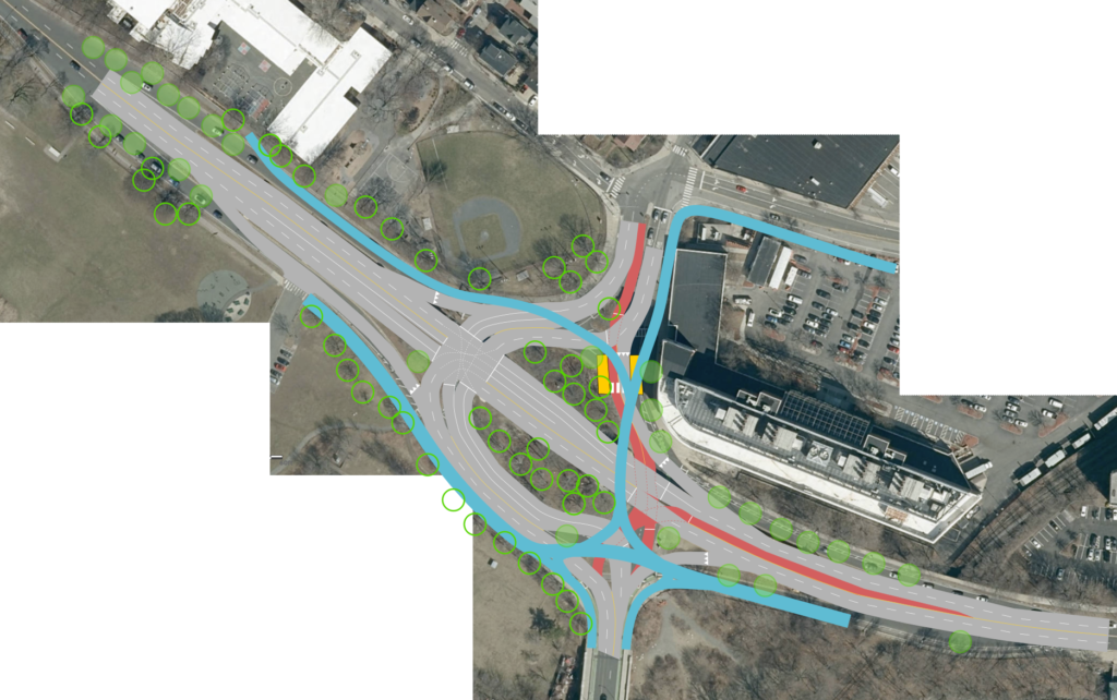
For east-west bike/ped users, the ramp would rise starting at the existing entrance to the Magazine Beach park, allow users to go to or from the BU Bridge, and then extend east at a level to reach the existing Grand Junction bridge. For north-south users, the route would loop onto the connector to near the 640 Memorial Drive building and have two downramp options, one to and from Waverly Street and the other to the existing Memorial Drive right-of-way, which would be narrowed considerably, and then extending towards Pearl Street. The only downside would be for direct access to Brookline Street, where users would have to make a U-turn on Waverly to access Brookline, as there is not enough room to run a ramp down to the Waverly-Brookline intersection. However, given the upslope of Brookline Street and the MIT-owned property to the east, it’s possible that a bike/ped connection to Brookline could extend north across Waverly and join Brookline at Henry Street (this is not shown).
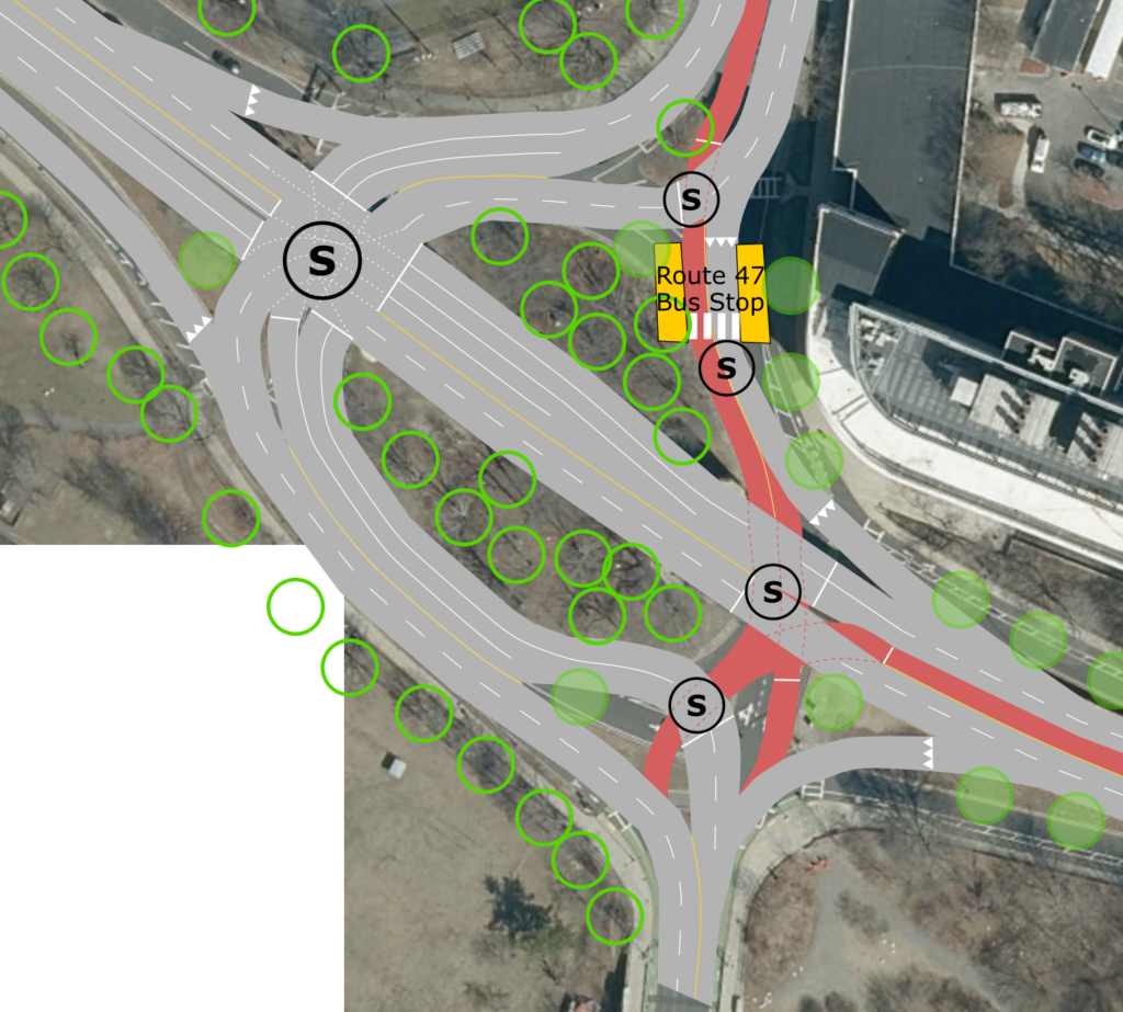
Removing the overpass, this sketch shows the proposed traffic slows. The four smaller (S) symbols on the right show signals which would only be used for transit operations (or the pedestrian crosswalk to a bus stop), and would let the main traffic flow about 90% of the time. The main signal would be to the northeast of the existing “oval.”
- From the BU Bridge traffic from the single lane from the south would filter either right onto Memorial Drive (this is a heavy traffic movement and would be unimpeded by signals or bike/ped traffic) or left around the oval, where it would have three lanes of queue space so that when the signal is active, it could utilize the full capacity of the roadway.
- On Memorial Drive in both directions, right turns would be filtered off, with two through lanes at the traffic light. Single left turn lanes would be provided except for a double-left for the heavy demand from Memorial Drive westbound to the BU Bridge south.
- From Cambridgeport traffic would follow its existing path around the oval, through the traffic light with a left turn lane, and then merge with the right-turning traffic from Memorial Drive to access two lanes on the BU Bridge itself. This would allow more efficient use of the southbound signal phase at the south end of the bridge, where there is currently a single lane—interrupted by frequent pedestrian crossings—feeding minimal queue space, which would alleviate traffic backups in the existing rotary.
- For Transit, the southbound 47 bus would use a left-side bus lane and cross Cambridgeport-bound traffic at a signal to access a bus stop accessible from 64 Memorial Drive. This could replace the existing bus stop on Granite Street, allowing a left-side bus-and-left-turn only lane to bypass additional queues. Buses would then proceed though two transit signals to allow them to merge into BU bridge traffic going south. The northbound 47 would use one of these transit signals to access a mixed-traffic lane from Memorial Drive west to Cambridgeport (a low-volume movement) and a bus stop there. The northbound CT2 would use the general traffic lane, while the southbound CT2 would use a bus lane to bypass the main traffic signal.
Show up on January 6 (next Tuesday) and tell MassDOT that you demand a plan which puts the safety of bicycles and pedestrians first, and that a bridge should be built, but not for cars. And if someone has spiked the bubbles at 10 Park Plaza (or, more likely, their consultant) and DOT shows up with a bike/ped-first plan, make sure they know that the community demands it.