
Or: why it matters where you draw boundaries. (Or, more specifically, the modifiable aerial unit problem. Thanks, Twitter.)
If you go to the wonderful density.website and find the census tract with, in 2016, as close to 100,000 people per square mile as you can, you’ll wind up in Los Angeles (believe it or not). If you then click the “up” arrow, you can cycle through denser and denser census tracts, and you’ll see a lot of New York City (sometimes the map in the UI doesn’t even reload, but just recenters to a nearby tract). There are a couple of tracts in San Francisco in the 100,000 to 200,000 range, and eventually you’ll get to Le Frak City (click the link to save the trouble of clicking through) which, at 250,000 people per square mile, is the densest tract in New York (about 14,000 people living in about 1/20th of a square mile, give or take).
But go ahead and click the arrow once again.
The page will reload and you’ll be transported not to Brooklyn or Manhattan or the Bronx, but to Chicago. The tract in question has about 1600 people living in 0.003 square miles: two residential towers in Edgewater, on Lake Shore Drive, several miles from the Loop. It’s a bizarrely-drawn tract almost entirely surrounded by a much larger tract, and if the two were combined the resulting tract would be home to about 35,000 people per square mile, on par for the surrounding neighborhood but nowhere near as dense as much of New York City. (The second-densest current tract in Chicago is also made up of North Side high rises at about 90,000 per square mile, but the Robert Taylor Homes, which once housed 27,000 people on 95 acres, was in the neighborhood of 180,000. Cabrini-Green may have been denser still.)
In fact, New York isn’t even the densest city in the country, with several small cities across the river in New Jersey (and one Hasidic village in Rockland County) higher. Manhattan (New York County) is the most densely-populated county in the country at 70,000 people per square mile (although at its peak population in the early 1900s, it was over 100,000; on par with Manila). Two, three and four? Kings (Brooklyn), Bronx and Queens. Of course, New York State is the 8th most densely populated state, and that’s not counting DC, Puerto Rico, Guam, the Virgin Islands and American Samoa. It all depends on where you draw the line.
Which brings us to a New York Times article about downtown areas and their post-covid resilience. They use downtown areas, as defined by CoStar here (the website is a time capsule from the mid-2000s). The issue: there is huge variation between the size of the defined “downtown” areas: in some cases they carefully clip out non-housing areas, in others, they just draw a box around the downtown. The thesis of the article is:
What remain[s] at the heart of many cities in the 20th century [are] blocks and blocks of office buildings filled perhaps 10 hours a day, five days a week — a precarious urban monoculture. […] That means there are few residents to support restaurants at night or to keep lunch counters open if office workers stay away, and few reasons for visitors to spend time or money there on the weekend.
Here is how the story shows the downtowns for Austin and Boston, with the black bar showing a quarter mile. They appear to be similar in size, however, Boston is about 0.37 square miles, while Austin is 1.7 square miles. Not only is that a nearly 5-fold difference, but the Boston metro area is more than twice the size of Austin, so we’d expect a more agglomerated Downtown area with more office space.
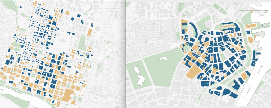
The real kicker is that Boston’s Downtown, as defined by CoStar, is surrounded by residential neighborhoods, none more than a 10 minute walk away. Except for the area in the direction of Back Bay, the gray areas surrounding Downtown Boston include Beacon Hill, the West End, the North End, Chinatown and Bay Village, all residential areas. If you take the neighborhoods on the Shawmut peninsula and Beacon Hill, it adds up to about to about 1.5 square miles, with about 41,000 people. Slightly-larger Downtown Austin? It’s grown significantly in recent years, but still is home to only about 12,000 people.
In the article the CBD sizes range from Boston at 0.37 miles to New York, where the CBD is defined as “everything south of 59th Street” which encompasses 9 square miles (New York’s MSA is 5 times the size of Boston’s, but the “downtown” is 24 times larger). Minneapolis is 4 square miles, Saint Paul 0.67. In many cases, the “downtown” area is defined by the highways around it. Other cities, like San Francisco, have several defined districts defined as the “CBD”; San Francisco’s “Financial District” would probably rate similarly to Boston’s in the proportion of office space, and certainly as less office-dense than their Grand Central-defined parcel in New York.
So it’s true that in the Financial District of Boston itself there aren’t many residents. Yet a similarly-drawn box carved into Austin, or most any other city noted in the article, would find the same thing. Taken to a logical extreme, a small box around a single office building would be 100% office use. Or a single tract: there’s one in Midtown Manhattan with a population density less than 1000. There are just 44 residents in the tract bounded by 5th and Park avenues, and 42nd and 49th streets. Of course, just to the east, Murray Hill and Midtown East have 100,000 people per square mile. It turns out that aggregations of this size and variability are not appropriate for this sort of analysis.
Commuting and office use patterns will certainly change post-pandemic. 9-to-5 office districts may be less valuable, and some real estate may be converted to other uses: the article notes an evolution away from single-purpose downtowns. There may be a better metric of office density, perhaps using a certain land area based on the size of the city. But comparing wildly differently-sized “downtown” areas is like saying that, because the densest census tract in the country is in Chicago, Chicago must be the most densely-populated city in the country.