When the whole melee about Cobb County Braves broke last month it got me thinking about a long-thought project of mine: calculating travel mode share to baseball parks. Ballparks see the most visits of any sport (a multipurpose arena with hockey and basketball only has as many home games as a baseball team, with half the capacity), and ballparks are often (although not in the case of the Braves) seen as means to revitalize downtown areas.
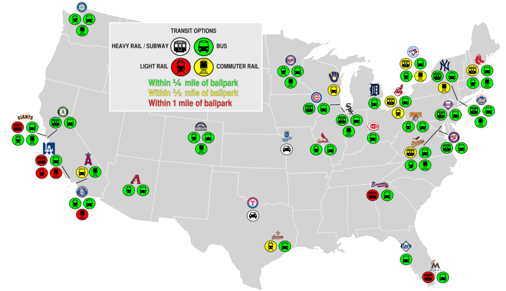
So, I created a chart of each stadium, and how far it was from various transit modes. And then I mapped it out:
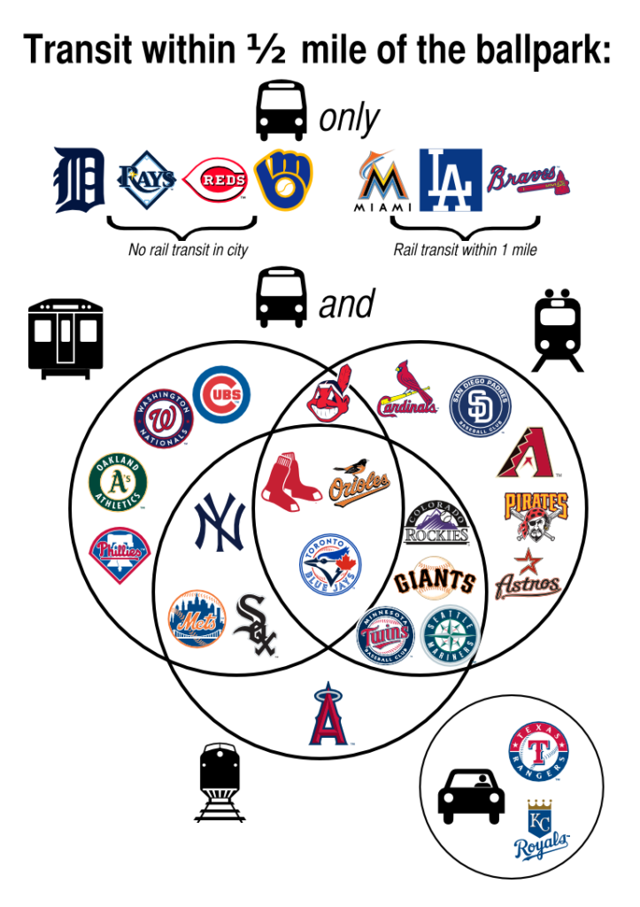
Green shows transit options within ¼ mile, or a five minute walk. Yellow is within ½ mile (10 minutes) and red within a mile (20 minutes). Note that bus stops more than half a mile form the stadium are not shown. Here is a Venn-ish diagram of the same data:
- 28 ballparks lie within half a mile of some transit option. (The exceptions: Arlington, Texas—which doesn’t even have transit within the city limits!—and Kansas City, have bus stops less than a mile away.)
- 3 cities have no rail transit but do have bus service. Miller Park, built with huge parking lots for tailgaiting Wisconsinites, is the only one of these ballparks more than a quarter mile from the nearest bus stop.
- Boston, Baltimore and Toronto have all four transit options within half a mile of the stadium. (In Boston, the Green Line, despite carrying more passengers than several subway systems, is classified as light rail; the Orange Line, half a mile away, is the heavy rail option.)
- Denver is opening a multi-modal station near the current ballpark, this reflects the projected opening next year.
- The Braves new ballpark will be nearly a mile from the nearest bus stop, putting it in the company of Texas and Kansas City.
- Historically, ballparks were often further from the city center, and served mainly by streetcars, even in cities with subways. Braves Field, Shibe Park, Ebbets Field and the Polo Grounds were all closer to streetcars than to subways. (And note that Fenway Park, Yankee Stadium, and both ballparks in Chicago are not in the downtown core.)


Ballparks were low-value, sprawly uses of land, so naturally they were placed on what was the edges of the urbanized area at the time, wherever was cheap. The city grew up around them, often displacing the park eventually.
Nice post though! I've been thinking about doing something related for a while: comparing the walkability of various ballpark neighborhoods. For example, Fenway, while surrounded by garages, comes out much more favorably than say, Dodger Stadium, which looks like it was built in a lunar crater.
Very true re: the land value of ballparks. There are sort of four eras of ballparks. The first was pre-bandbox, when parks sat 12k or so in wooden stands. The second were the bandboxes. Built out at the same time as residential neighborhoods along streetcar (or sometimes subway) lines and in many cases built right in the middle of residential neighborhoods (e.g. Shibe, Sportsman's, Ebbets, Tiger). Then there were the cookie cutter era, although some of these were set down in downtowns. And since then, the retro movement, especially with downtown ballparks.
What's interesting about Fenway is that the garages are going the way of the Dodo. I was always intrigued growing up by the myriad garages and parking lots around Fenway—within a mile of the Prudential and Longwood. For a while, I think that there was more value in these lots as low-rise parking facilities or lots, especially given that supply and demand would allow for high amounts of cash per year. However, it seems that as housing prices have risen, the price of these parcels as residential properties (certainly a "better and higher use") has changed the equation and much of the area is being redeveloped. This is certainly a good thing, although it might squeeze parking rates higher at existing lots.
A final note: Fenway didn't have below-grade transit nearby until 1932, when the subway was extended beyond Kenmore to the Beacon and Commonwealth portals.